Scientific Investigations Report 2010–5065
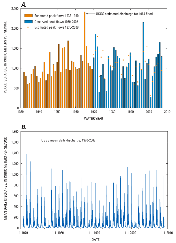
Figure 2. Flow records for USGS streamflow-gaging station 14400000, Chetco River near Brookings, Oregon. (A) Estimated and observed annual peak flows for water years 1932–2008. (B) Mean daily discharge for water years 1970–2008. Annual peak flows measured for water years 1971–2008, estimated for 1964 on basis of high water mark and extension of rating curve, and estimated for all other years using data from Smith River USGS streamflow-gaging station (11532500) in northern California. Estimates from Smith River record were determined by regression of log-transformed values from period of overlap for which log Chetco River Qpeak = 0.6337 × (log Smith River Qpeak) + 1.4708 (r = 0.83). |
First posted May 26, 2010 For additional information contact: Part or all of this report is presented in Portable Document Format (PDF); the latest version of Adobe Reader or similar software is required to view it. Download the latest version of Adobe Reader, free of charge. |

![]() U.S. Department of the Interior | U.S. Geological Survey
U.S. Department of the Interior | U.S. Geological Survey
URL: http://
pubsdata.usgs.gov
/pubs/sir/2010/5065/figure2.html
Page Contact Information: Contact USGS
Page Last Modified:
Thursday, 10-Jan-2013 19:10:47 EST
