 Abstract
The National Water-Quality Assessment Program (NAWQA) of the U.S. Geological Survey began a series of groundwater studies in 2001 in representative aquifers across the Nation in order to increase understanding of the factors that affect transport of anthropogenic and natural contaminants (TANC) to public-supply wells. One of 10 regional-scale TANC studies was conducted in the Middle Rio Grande Basin (MRGB) in New Mexico, where a more detailed local-scale study subsequently investigated the hydrogeology, water chemistry, and factors affecting the transport of contaminants in the zone of contribution of one 363-meter (m) deep public-supply well in Albuquerque. During 2007 through 2009, samples were collected for the local-scale study from 22 monitoring wells and 3 public-supply (supply) wells for analysis of major and trace elements, arsenic speciation, nutrients, dissolved organic carbon, volatile organic compounds (VOCs), dissolved gases, stable isotopes, and tracers of young and old water. To study groundwater chemistry and ages at various depths within the aquifer, the monitoring wells were divided into three categories: (1) each shallow well was screened across the water table or had a screen midpoint within 18.3 m of the water level in the well; (2) each intermediate well had a screen midpoint between about 27.1 and 79.6 m below the water level in the well; and (3) each deep well had a screen midpoint about 185 m or more below the water level in the well.
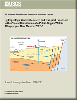
The 24-square-kilometer study area surrounding the “studied supply well” (SSW), one of the three supply wells, consists of primarily urban land within the MRGB, a deep alluvial basin with an aquifer composed of unconsolidated to moderately consolidated deposits of sand, gravel, silt, and clay. Conditions generally are unconfined, but are semiconfined at depth. Groundwater withdrawals for public supply have substantially changed the primary direction of flow from northeast to southwest under predevelopment conditions, to west to east under modern conditions.
Analysis of age tracers indicates that groundwater from most sampled wells is dominated by old (pre-1950) water, ranging in mean age from about 4,000 years to more than 22,000 years, but includes a fraction of young (post-1950) recharge. Patterns in chemical and isotopic data are consistent with the conclusions that shallow groundwater in the area typically includes a fraction that evaporated prior to recharge and (or) flushed accumulated solutes out of the unsaturated zone during recharge, and that shallow groundwater has mixed to deeper parts of the aquifer, which receives recharge mainly by seepage from the Rio Grande.
Among shallow and intermediate wells that produced water with a fraction of young recharge, that fraction ranged between 1.5 and 46 percent. Samples from the two deep wells had groundwater ages exceeding 18,000 years, with no fraction of young recharge. Two supply wells (including the SSW) had a fraction of young recharge, which ranged between about 3 and 11 percent, despite mean groundwater ages exceeding 10,000 years. The fraction of young recharge to the SSW varied seasonally, probably because seasonal pumping patterns affected local hydraulic gradients and (or) because of flow through the well bore when the SSW is not pumping. Well-bore flow data collected during winter (low-pumping season) indicated that about 61 percent of the water pumped from the SSW entered the well from the intermediate part of the aquifer, and that the remaining 39 percent entered from the deep part of the aquifer.
Volatile organic compounds (VOCs) were detected in samples from most shallow and intermediate monitoring wells and from two of three supply wells, including the SSW. Detected VOCs were primarily chlorinated solvents or their degradation products. Many of the wells in which most of these VOCs were detected are located near known sites of solvent contamination that were targeted for sampling because trichloroethylene (TCE) and cis-1,2-dichloroethylene had been detected in the SSW, and several of these wells may have become contaminated at least partly because of enhanced vertical migration associated with the pumping of and (or) direct migration down deep well bores. Except for TCE in the sample from a shallow monitoring well, all detections of VOCs were at concentrations below Maximum Contaminant Levels (MCLs) set by the U.S. Environmental Protection Agency. Concentrations of all VOCs detected in the supply wells were less than one-tenth of the corresponding MCLs. However, the presence of VOCs in all but deep groundwater, including the detection of chloroform (a chlorination byproduct) in several shallow wells, indicates that groundwater in the study area commonly is affected by human activities, even to substantial depths.
The only natural contaminant detected at concentrations near or above its MCL was arsenic, which has been detected at elevated concentrations across broad areas of the MRGB. Concentrations of arsenic, present primarily as arsenate, exceeded the MCL of 10 micrograms per liter (μg/L) in water from the two deep wells (one of which had the highest concentration, 35 μg/L), from one intermediate well, and from two supply wells, including the SSW. Water-quality and solid-phase data from this study are consistent with elevated arsenic concentrations in groundwater being related to pH-dependent desorption of arsenic from ferric oxyhydroxides in sediments in deep parts of the aquifer.
Concentrations of nitrate ranged between 1.3 and 5.4 milligrams per liter (mg/L) in water from shallow wells screened across the water table, but were less than 0.9 mg/L in water from all but one deeper well. Nitrogen isotopes and chloride/bromide ratios for shallow wells were consistent with natural soil nitrogen. Nitrate concentrations and nitrogen isotopes indicated that denitrification is occurring at intermediate aquifer depths, and that the progress of the denitrification reaction typically is greatest for wells that include a fraction of groundwater associated with particular recharge sources or with known sites of contamination contributing organic compounds that can provide a carbon source for microbial respiration.
Overall, hydrologic and chemical data from the study area indicate that young recharge is reaching the aquifer across broad areas and is migrating from shallow to intermediate depths of the aquifer as a result of mixing that is associated with human development of groundwater. Consequently, groundwater that human activities in the urban study area have affected is present at depths that are within the screened intervals of public-supply wells, resulting in detections of VOCs and implying greater vulnerability to anthropogenic contamination than might be assumed based on the dominantly old age of the regional groundwater. However, the fractions of old groundwater that public-supply wells produce substantially dilute the anthropogenic contaminants, while contributing natural contaminants (primarily arsenic) to the wells. Based on data from the SSW, vulnerability of public-supply wells to natural and anthropogenic contaminants in the area changes through time, including with seasonal changes in pumping stresses that alter the fractions of young and old water being contributed to wells.

