Scientific Investigations Report 2012–5002
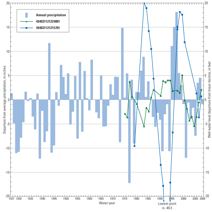
Figure 19. Decadal response of water levels in Mosier, Oregon, study area wells to precipitation‑driven recharge (precipitation measured at nearby Hood River, Oregon). Water levels in a shallow basalt well (454031121215701) show a definite response to wet and dry periods, but most Oregon Water Resources Department administrative area wells (typified by the proximal well 454031121224001) are deeper, showing a lagged, attenuated response. Data for both wells have been de-trended by removing a linear 3.9-foot-per-year decline, and by using water levels representative of late winter to remove seasonal variation. |
First posted March 1, 2012
For additional information contact: Part or all of this report is presented in Portable Document Format (PDF); the latest version of Adobe Reader or similar software is required to view it. Download the latest version of Adobe Reader, free of charge. |

![]() U.S. Department of the Interior |
U.S. Geological Survey
U.S. Department of the Interior |
U.S. Geological Survey
URL: http://pubsdata.usgs.gov/pubs/sir/2012/5002/figure19.html
Page Contact Information: GS Pubs Web Contact
Page Last Modified: Thursday, 10-Jan-2013 19:48:23 EST
