Scientific Investigations Report 2012–5017
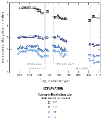
Figure 14. Trends in stage of water-surface elevation at the U.S. Geological Survey streamflow-gaging station 14200000, Molalla River near Canby, Oregon. (Stage was determined for the 5-year recurrence-interval peak [570 m3/s, or 20,100 ft3/s], the 5 percent exceedance value [110 m3/s, or 3,800 ft3/s], the median discharge [19 m3/s, or 670 ft3/s], and the 95 percent exceedance value [1.7 m3/s, or 60 ft3/s]. Gaging station moves and datum shifts are shown on the graph as is the peak of record on December 22, 1964.) |
First posted February 29, 2012 For additional information contact: Part or all of this report is presented in Portable Document Format (PDF); the latest version of Adobe Reader or similar software is required to view it. Download the latest version of Adobe Reader, free of charge. |

![]() U.S. Department of the Interior |
U.S. Geological Survey
U.S. Department of the Interior |
U.S. Geological Survey
URL: http://pubsdata.usgs.gov/pubs/sir/2012/5017/figure14.html
Page Contact Information: GS Pubs Web Contact
Page Last Modified: Thursday, 10-Jan-2013 19:47:07 EST
