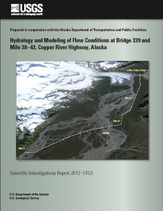
Scientific Investigations Report 2012–5153
|
First posted August 14, 2012 For additional information contact: Part or all of this report is presented in Portable Document Format (PDF); the latest version of Adobe Reader or similar software is required to view it. Download the latest version of Adobe Reader, free of charge. |
Brabets, T.P., 2012, Hydrology and modeling of flow conditions at Bridge 339 and Mile 38–43, Copper River Highway, Alaska: U.S. Geological Survey Scientific Investigations Report 2012–5153, 26 p.
Abstract
Introduction
Hydrology at Bridge 339
FaSTMECH Modeling System
Summary and Conclusions
Acknowledgments
References Cited

![]() U.S. Department of the Interior |
U.S. Geological Survey
U.S. Department of the Interior |
U.S. Geological Survey
URL: http://pubsdata.usgs.gov/pubs/sir/2012/5153/index.html
Page Contact Information: GS Pubs Web Contact
Page Last Modified: Thursday, 10-Jan-2013 19:58:23 EST