 Abstract Abstract
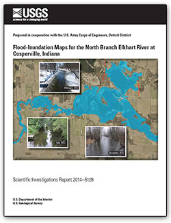
Digital flood-inundation maps for a reach of the North Branch Elkhart River at Cosperville, Indiana (Ind.), were created by the U.S. Geological Survey (USGS) in cooperation with the U.S. Army Corps of Engineers, Detroit District. The inundation maps, which can be accessed through the USGS Flood Inundation Mapping Science Web site at http://water.usgs.gov/osw/flood_inundation/ depict estimates of the areal extent and depth of flooding corresponding to selected water levels (stages) at USGS streamgage 04100222, North Branch Elkhart River at Cosperville, Ind. Current conditions for estimating near-real-time areas of inundation using USGS streamgage information may be obtained on the Internet at http://waterdata.usgs.gov/in/nwis/uv?site_no=04100222. In addition, information has been provided to the National Weather Service (NWS) for incorporation into their Advanced Hydrologic Prediction Service (AHPS) flood warning system (http:/water.weather.gov/ahps/). The NWS AHPS forecasts flood hydrographs at many places that are often colocated with USGS streamgages, including the North Branch Elkhart River at Cosperville, Ind. NWS AHPS-forecast peak-stage information may be used in conjunction with the maps developed in this study to show predicted areas of flood inundation.
For this study, flood profiles were computed for the North Branch Elkhart River reach by means of a one-dimensional step-backwater model. The hydraulic model was calibrated by using the most current stage-discharge relations at USGS streamgage 04100222, North Branch Elkhart River at Cosperville, Ind., and preliminary high-water marks from the flood of March 1982. The calibrated hydraulic model was then used to determine four water-surface profiles for flood stages at 1-foot intervals referenced to the streamgage datum and ranging from bankfull to the highest stage of the current stage-discharge rating curve. The simulated water-surface profiles were then combined with a geographic information system (GIS) digital elevation model (DEM, derived from Light Detection and Ranging [LiDAR]) in order to delineate the area flooded at each water level.
The availability of these maps, along with Internet information regarding current stage from the USGS streamgage 04100222, North Branch Elkhart River at Cosperville, Ind., and forecast stream stages from the NWS AHPS, provides emergency management personnel and residents with information that is critical for flood response activities such as evacuations and road closures, as well as for post-flood recovery efforts.
|
First posted July 24, 2014
Part or all of this report is presented in Portable Document Format (PDF). For best results viewing and printing PDF documents, it is recommended that you download the documents to your computer and open them with Adobe Reader. PDF documents opened from your browser may not display or print as intended. Download the latest version of Adobe Reader, free of charge. More information about viewing, downloading, and printing report files can be found here.
|

