Water Data Report 1997
					Wyandot County

				405009083172600. LOCAL NUMBER, WY-1

LOCATION.--Lat 40050'09", long 83017'26", Hydrologic Unit 04100011, State Rt 199, Upper Sandusky.
   Owner: Karg Supply Co.
AQUIFER.--Limestone of Silurian Age.
WELL CHARACTERISTICS.--Drilled unused artesian well, diameter 5 in, depth 90 ft, cased.
INSTRUMENTATION.--Digital recorder--60-minute punch.
DATUM.--Elevation of land-surface datum is 850 ft above sea level, from topographic map.
   Measuring point: Floor of instrument shelter 3.00 ft above land-surface datum.
REMARKS.--Station operated by Ohio Department of Natural Resources, Division of Water.
PERIOD OF RECORD.--September 1951 to current year.
EXTREMES FOR PERIOD OF RECORD.--Maximum daily low, 40.90 ft below land-surface datum, July 12, 15, 17, 21,
   Aug. 26, 1961; minimum daily low, 25.65 ft below land-surface datum, June 5, 1997.


			DEPTH BELOW LAND SURFACE (WATER LEVEL) (FEET), WATER YEAR OCTOBER 1996 TO SEPTEMBER 1997
							DAILY MAXIMUM VALUES

 DAY       OCT      NOV      DEC      JAN      FEB      MAR      APR      MAY      JUN      JUL      AUG      SEP

   1     27.93    27.97    28.11    27.09    26.98    26.56    26.39    26.31    26.20    27.23    27.25    27.73
   2     28.02    28.18    27.91    27.06    26.92    26.24    26.30    26.36    25.86    27.15    27.41    27.75
   3     27.92    28.40    27.67    26.74    27.07    26.32    26.20    26.38    25.84    27.13    27.52    27.62
   4     27.89    28.27    27.76    26.48    27.08    26.58    26.45    26.45    25.71    27.08    27.52    27.32
   5     27.96    27.90    27.84    26.55    27.03    26.59    26.46    26.44    25.65    27.07    27.29    27.26

   6     27.93    27.75    27.84    27.08    27.13    26.65    26.13    26.44    25.98    27.18    27.09    27.55
   7     28.00    27.71    27.80    27.19    27.20    26.72    26.28    26.46    26.05    27.20    27.07    27.82
   8     27.93    27.65    27.81    27.36    27.22    26.71    26.46    26.38    26.12    27.35    27.37    27.84
   9     27.84    27.62    27.94    27.40    27.32    26.66    26.71    26.53    26.21    27.36    27.60    27.81
  10     27.89    27.73    27.98    27.37    27.15    26.43    26.68    26.58    26.40    27.02    27.56    27.25

  11     27.91    28.07    27.75    27.80    27.06    26.28    26.52    26.53    26.46    27.17    27.59    27.22
  12     27.87    28.36    27.53    28.07    27.14    26.40    26.34    26.39    26.46    27.28    27.55    27.33
  13     28.13    28.52    27.38    28.13    27.33    26.48    26.08    26.39    26.54    27.29    27.66    27.56
  14     28.27    28.53    27.66    28.02    27.31    26.39    26.16    26.59    26.55    27.39    27.58    27.58
  15     28.04    28.55    27.58    27.94    27.24    26.37    26.19    26.52    26.48    27.45    27.59    27.57

  16     27.79    28.48    27.48    27.78    27.23    26.40    26.16    26.34    26.54    27.47    27.96    27.58
  17     27.72    28.41    27.40    27.94    27.24    26.37    26.22    26.52    26.57    27.47    27.96    27.55
  18     27.72    28.22    27.37    27.97    27.23    26.18    26.22    26.68    26.68    27.47    27.90    27.54
  19     27.57    28.12    27.72    28.00    26.98    26.08    26.03    26.68    26.70    27.50    27.48    27.74
  20     27.57    27.96    27.98    27.99    26.95    26.06    25.98    26.49    26.89    27.48    27.23    27.76

  21     27.57    28.12    28.00    27.85    26.79    25.95    25.95    26.41    27.16    27.43    27.13    27.63
  22     27.50    28.37    27.82    27.74    26.57    25.71    25.88    26.42    27.32    27.44    27.15    27.51
  23     27.56    28.39    27.55    27.25    26.74    26.08    25.98    26.34    27.35    27.41    27.28    27.38
  24     27.69    28.34    27.33    27.20    27.10    26.26    26.19    26.68    27.28    27.26    27.29    27.34
  25     27.75    28.25    27.61    27.44    27.14    26.23    26.27    26.69    27.38    27.43    27.25    27.25

  26     28.00    28.28    27.65    27.64    27.02    26.17    26.40    26.48    27.38    27.55    27.27    27.27
  27     28.03    28.31    27.68    27.38    26.72    26.22    26.40    26.44    27.23    27.63    27.36    27.41
  28     27.89    28.35    27.46    27.31    26.58    26.06    26.32    26.19    27.28    27.63    27.39    27.44
  29     27.73    28.32    27.00    27.42      ---    25.99    26.29    26.17    27.29    27.53    27.40    27.45
  30     27.62    28.29    26.91    27.40      ---    26.00    26.30    26.30    27.28    27.17    27.53    27.25
  31     27.96      ---    27.07    27.23      ---    26.24      ---    26.30      ---    27.02    27.58      ---

 MAX     28.27    28.55    28.11    28.13    27.33    26.72    26.71    26.69    27.38    27.63    27.96    27.84

 CAL YR 1996   LOW 28.80
 WTR YR 1997   LOW 28.55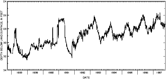

![]() U.S. Department of the Interior |
U.S. Geological Survey
U.S. Department of the Interior |
U.S. Geological Survey
URL: http://pubsdata.usgs.gov/pubs/wdr/1997/oh-97-2/sw97/405009083172600.html
Page Contact Information: GS Pubs Web Contact
Page Last Modified: Thursday, 25-Oct-2018 15:18:09 EDT
