Water Data Report 1997
						Van Wert County

					405215084335400. LOCAL NUMBER, VW-1

LOCATION.--Lat 40052'15", long 84033'54", Hydrologic Unit 04100007, Ridge Road near Van Wert.
   Owner: Marsh Foundation.
AQUIFER.--Limestone of Silurian Age.
WELL CHARACTERISTICS.--Drilled unused artesian well, diameter 8 in., depth 340 ft, cased.
INSTRUMENTATION.--Type F continuous recorder.
DATUM.--Elevation of land-surface datum is 790.37 ft above sea level.
   Measuring point: Floor of instrument shelter 6.15 ft above land-surface datum.
REMARKS.--Station operated by Ohio Department of Natural Resources, Division of Water.
PERIOD OF RECORD.--August 1957 to current year.
EXTREMES FOR PERIOD OF RECORD.--Maximum daily low 33.20 ft below land-surface datum, Dec. 20-21, 1991;
   minimum daily low, 18.85 ft below land-surface datum, Mar. 6, 1959.


			DEPTH BELOW LAND SURFACE (WATER LEVEL) (FEET), WATER YEAR OCTOBER 1996 TO SEPTEMBER 1997
							DAILY MAXIMUM VALUES

 DAY       OCT      NOV      DEC      JAN      FEB      MAR      APR      MAY      JUN      JUL      AUG      SEP

   1     26.95    26.65    26.45    26.60    26.10    25.65    25.90    25.75    25.55    26.00    25.90    26.05
   2     26.95    26.90    26.65    26.20    26.25    25.90    25.90    25.75    25.35    25.60    25.85    26.15
   3     27.05    26.90    26.75    26.10    26.35    25.90    25.85    25.70    25.50    25.60    25.95    26.15
   4     27.10    27.00    26.95    26.10    26.25    25.90    25.70    25.85    25.55    25.70    26.00    26.10
   5     27.00    26.95    26.90    26.00    26.30    25.90    25.60    25.90    25.50    25.80    26.20    26.20

   6     26.90    26.90    26.50    26.30    26.30    26.10    25.45    25.90    25.45    25.80    26.30    26.30
   7     26.70    26.75    26.45    26.40    26.30    26.15    25.75    26.00    25.55    25.85    26.35    26.30
   8     26.60    26.60    26.50    26.55    26.35    26.15    25.90    25.85    25.55    25.75    26.35    26.20
   9     26.75    26.65      ---    26.45    26.40    26.20    25.95    25.75    25.65    25.75    26.25    26.10
  10     27.15    26.80      ---    25.80    26.30    25.90    25.95    25.85    25.70    25.80    26.30    26.10

  11     27.25    27.10      ---    26.20    26.20    25.95    25.85    25.80    25.65    25.80    26.45    26.15
  12     27.20    27.25      ---    26.50    26.40    26.05    25.60    25.50    25.50    25.80    26.50    26.15
  13     27.10    27.30      ---    26.70    26.45    26.05    25.70    25.55    25.30    25.65    26.45    26.10
  14     27.05    27.30      ---    26.70    26.10    25.85    25.85    25.55    25.55    25.45    26.45    26.05
  15     27.05    27.35      ---    26.65    26.35    25.95    25.90    25.75    25.65    25.65    26.35    25.95

  16     26.85    27.20      ---    26.05    26.50    26.05    25.80    25.85    25.60    25.90    26.10    25.80
  17     26.75    27.05      ---    26.30    26.50    26.00    25.70    25.65    25.55    25.90    26.15    25.90
  18     26.70    26.95      ---    26.30    26.30    25.95    25.65    25.65    25.55    25.90    26.25    25.80
  19     26.75    26.80      ---    26.35    26.30    25.95    25.50    25.65    25.65    26.00    26.25    25.80
  20     26.70    26.85      ---    26.20    26.30    25.80    25.55    25.85    25.70    26.10    26.15    26.00

  21     26.75    26.95      ---    26.40    25.95    25.60    25.50    26.10    25.70    26.05    25.90    25.95
  22     26.65    27.05      ---    26.30    26.20    25.65    25.50    26.20    25.90    25.95    25.85    25.80
  23     26.50    26.95      ---    26.30    26.35    25.75    25.50    26.20    25.95    25.85    25.95    25.80
  24     26.75    26.90      ---    26.35    26.45    26.00    25.60    26.05    26.05    25.80    25.95    25.70
  25     26.80    26.90      ---    26.10    26.40    26.00    25.90    25.85    26.00    25.80    25.85    25.65

  26     26.90    27.10    26.55      ---    26.10    25.75    25.95    25.80    26.05    25.65    25.80    25.70
  27     26.95    27.20    26.55      ---    25.70    25.80    25.85    25.90    26.20    25.60    25.85    25.70
  28     26.85    27.15    26.35    26.65    25.85    25.60    25.60    25.95    26.20    25.65    25.70    25.50
  29     26.80    26.95    26.50    26.50      ---    25.40    25.65    25.90    26.10    25.80    25.65    25.30
  30     26.65    26.70    26.60    26.35      ---    25.60    25.55    25.80    26.05    25.90    25.70    25.55
  31     26.75      ---    26.60    26.00      ---    25.80      ---    25.75      ---    26.00    25.65      ---

 MAX     27.25    27.35    26.95    26.70    26.50    26.20    25.95    26.20    26.20    26.10    26.50    26.30

 CAL YR 1996   LOW 28.30
 WTR YR 1997   LOW 27.35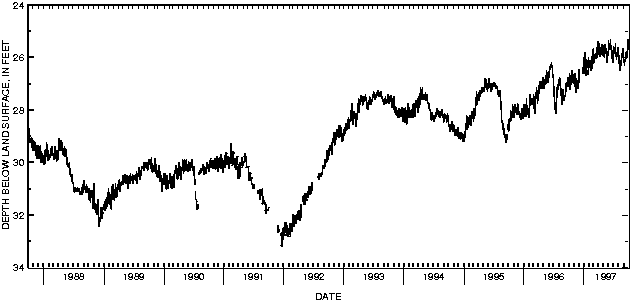

![]() U.S. Department of the Interior |
U.S. Geological Survey
U.S. Department of the Interior |
U.S. Geological Survey
URL: http://pubsdata.usgs.gov/pubs/wdr/1997/oh-97-2/sw97/405215084335400.html
Page Contact Information: GS Pubs Web Contact
Page Last Modified: Thursday, 25-Oct-2018 15:07:47 EDT
