Water Data Report 1997
							Medina County

						410142082005900. LOCAL NUMBER, MD-1
LOCATION.--Lat 41001'42", long 82000'59", Hydrologic Unit 04110001, at waterworks plant at Lodi.
   Owner: Lodi Water Dept.
AQUIFER.--Sand and gravel of Pleistocene Age.
WELL CHARACTERISTICS.--Drilled unused water-table well, diameter 6 in., depth 65 ft, cased.
INSTRUMENTATION.--Digital recorder--60-minute punch.
DATUM.--Elevation of land-surface datum is 910 ft above sea level, from topographic map.
   Measuring point: Floor of instrument shelter 1.90 ft above land-surface datum.
REMARKS.--Station operated by Ohio Department of Natural Resources, Division of Water.
PERIOD OF RECORD.--September 1946 to current year.
EXTREMES FOR PERIOD OF RECORD.--Maximum daily low, 45.21 ft below land-surface datum, July 8, 1988;
   minimum daily low, 7.60 ft below land-surface datum, July 6, 1969.


			DEPTH BELOW LAND SURFACE (WATER LEVEL) (FEET), WATER YEAR OCTOBER 1996 TO SEPTEMBER 1997
							DAILY MAXIMUM VALUES

 DAY       OCT      NOV      DEC      JAN      FEB      MAR      APR      MAY      JUN      JUL      AUG      SEP

   1     27.11    30.79    28.90    20.53    25.73    24.11    31.04    25.34    24.69    27.20      ---      ---
   2     25.33    26.44    24.37    23.61    25.51    24.13    30.09    27.50    27.30    25.86      ---      ---
   3     26.95    25.86    29.25    22.21    26.36    24.45    34.07    25.48    24.72    27.98      ---      ---
   4     26.00    27.05    25.88    21.11    25.97    26.13    26.25    23.62    25.53    25.16      ---      ---
   5     24.62    31.08    23.91    20.47    25.30    27.30    24.70    27.84    25.55    24.60      ---      ---

   6     22.66    34.74    25.62    23.04    26.05    25.88    23.08    26.26    26.87    24.93      ---      ---
   7     26.01    25.89    22.31    22.27    25.73    23.78    26.84    28.34    23.98    26.59      ---      ---
   8     25.94    25.49    21.07    22.93    26.01    23.41    24.52    28.89    23.24    27.51      ---      ---
   9     26.63    23.08    27.47    25.26    23.79    22.13    26.03    27.61    27.67    28.13      ---      ---
  10     24.35    22.71    26.71    23.30    25.46    26.37    25.72    26.57    25.56    29.74      ---      ---

  11     25.90    23.41    24.82    21.27    26.07    24.65    27.11    24.46    27.43    27.98      ---      ---
  12     27.21    26.52    23.17    22.58    26.53    23.85    24.39    25.92    27.00    26.45      ---      ---
  13     22.33    23.95    23.31    24.01    25.96    24.31    24.42    26.26    27.45    25.64      ---      ---
  14     25.95    22.93    21.39    22.76    27.04    25.38    24.87    27.17    25.53    30.35      ---      ---
  15     28.94    25.48    20.72    25.22    24.02    23.49    25.20    25.74    26.16    29.07      ---      ---

  16     29.44    23.11    22.59    24.06    24.41    21.61    25.36    27.07    26.63    29.00      ---      ---
  17     28.53    21.94    21.38    23.95    26.74    23.95    26.35    25.94    26.26    26.74      ---      ---
  18     26.29    24.15    23.05    23.93    25.90    23.83    24.84    24.55    27.47    28.04      ---      ---
  19     23.24    26.48    22.91    22.86    26.64    24.41    24.59    27.13    26.35    27.44      ---      ---
  20     27.79    23.46    22.33    26.54    24.29    26.40    23.59    27.93    26.93    26.10      ---      ---

  21     25.24    24.31    22.99    24.84    25.93    25.89    26.99    25.91    26.86    27.48      ---      ---
  22     23.61    25.89    23.45    25.68    24.57    23.31    26.30    28.33    25.15    27.02      ---      ---
  23     27.80    26.20    26.45    23.98    22.44    22.11    26.84    26.06    27.24    26.86      ---      ---
  24     25.69    23.67    23.11    23.46    28.33    25.87    28.39    25.37    27.55    28.46      ---      ---
  25     26.78    25.94    21.75    23.73    27.89    24.62    26.29    24.60    27.39    29.24      ---      ---

  26     25.57    25.06    22.92    23.28    27.63    23.72    25.46    25.91    31.15    26.78      ---      ---
  27     23.89    24.42    23.88    25.55    24.48    23.93    22.74    26.99    27.50    27.07      ---      ---
  28     27.03    21.85    22.41    24.59    24.94    23.76    26.63    30.88    26.63    28.05      ---      ---
  29     26.98    22.48    21.86    24.18      ---    23.04    26.82    27.24    25.42      ---      ---      ---
  30     27.27    24.25    23.31    23.91      ---    21.62    28.18    27.63    26.65      ---      ---      ---
  31     28.93      ---    23.21    26.18      ---    24.80      ---    25.18      ---      ---      ---      ---

 MAX     29.44    34.74    29.25    26.54    28.33    27.30    34.07    30.88    31.15    30.35      ---      ---

 CAL YR 1996   LOW 34.74
 WTR YR 1997   LOW 34.74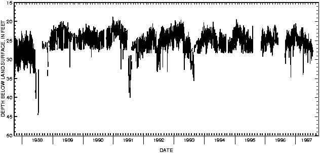

![]() U.S. Department of the Interior |
U.S. Geological Survey
U.S. Department of the Interior |
U.S. Geological Survey
URL: http://pubsdata.usgs.gov/pubs/wdr/1997/oh-97-2/sw97/410142082005900.html
Page Contact Information: GS Pubs Web Contact
Page Last Modified: Thursday, 25-Oct-2018 14:16:44 EDT
