Water Data Report 1997
							  Summit County

						410330081282000. LOCAL NUMBER, SU-6
LOCATION.--Lat 41003'30", long 81028'20", Hydrologic Unit 04110002, Seiberling St, Akron.
   Owner: Goodyear Tire and Rubber Co.
AQUIFER.--Sand and gravel of Pleistocene Age.
WELL CHARACTERISTICS.--Drilled unused artesian well, diameter 24 in., depth 89 ft, cased.
INSTRUMENTATION.--Digital recorder--60-minute punch.
DATUM.--Elevation of land-surface datum is 1000 ft above sea level from topographic map.
   Measuring point: Floor of instrument shelter 2.63 ft above land-surface datum.
REMARKS.--Station operated by Ohio Department of Natural Resources, Division of Water.
PERIOD OF RECORD.--March 1944 to current year. Records for May 14-Sept. 30, 1980, published in USGS-WDR-OH-80-1,
   are unreliable and should not be used.
EXTREMES FOR PERIOD OF RECORD.--Maximum daily low, 59.47 ft below land-surface datum, Oct. 18, 1947;
   minimum daily low, 10.19 ft below land-surface datum, May 12, 1996.


 			DEPTH BELOW LAND SURFACE (WATER LEVEL) (FEET), WATER YEAR OCTOBER 1996 TO SEPTEMBER 1997
							DAILY MAXIMUM VALUES

 DAY       OCT      NOV      DEC      JAN      FEB      MAR      APR      MAY      JUN      JUL      AUG      SEP

   1     13.78    13.25    12.43      ---    12.27    12.01    12.35    12.20    12.61    16.66    18.40    19.24
   2     13.81    13.24    12.49      ---    12.26    11.94    12.37    12.21    12.33    16.76    18.43    19.31
   3     13.84    13.23    12.52      ---    12.24    11.90    12.39    12.13    12.40    16.85    18.43    19.37
   4     13.84    13.20    12.54      ---    12.21    11.99    12.42    12.12    12.45    16.94    18.51    19.41
   5     13.83    13.19    12.40      ---    12.09    12.00    12.43    12.14    12.51    16.99    18.51    19.44

   6     13.82    13.19    12.39      ---    12.09    11.87    12.39    12.24    12.58    17.03    18.79    19.49
   7     13.78    13.15    12.35      ---    12.09    11.91    12.42    12.29    12.62    17.12    19.02    19.55
   8     13.80    13.11    12.28      ---    12.10    11.98    12.45    12.28    12.63    17.20    19.13    19.58
   9     13.83    13.11    12.36      ---    12.12    11.98    12.49    12.25    12.66    17.25    19.19    19.62
  10     13.85    13.04    12.42      ---    12.13    11.84    12.51    12.26    12.71    17.34    19.24    19.63

  11     13.87    13.01    12.43      ---    12.15    11.90    12.51    12.25    12.56    17.40    19.30    19.66
  12     13.85    12.86    12.33      ---    12.21    11.93    12.38    12.23    12.52    17.45    19.39    19.71
  13     13.82    12.83    12.36    12.36    12.22    11.94    12.11    12.25    12.53    17.54    19.41    19.75
  14     13.82    12.89    12.37    12.38    12.15    11.90    12.16    12.26    12.59    17.59    18.38    19.76
  15     13.84    12.98    12.34    12.36    12.19    11.95    12.16    12.30    12.61    17.64    18.00    19.80

  16     13.84    13.02      ---    12.33    12.21    11.98    12.13    12.34    12.62    17.70    17.99    19.83
  17     13.85    13.01      ---    12.35    12.24    11.96    12.07    12.35    12.64    17.77    17.87    19.85
  18     13.84    13.02      ---    12.38    12.19    11.99    12.08    12.44    12.65    17.82    17.82    19.88
  19     13.72    13.04      ---    12.38    12.16    11.99    12.09    12.66    12.68    17.84    17.91    19.88
  20     13.66    13.02      ---    12.36    12.16    12.02    12.09    12.74    12.72    17.86    17.94    19.87

  21     13.49    12.95      ---    12.39    12.11    12.02    12.07    12.81    12.72    17.94    17.95    19.69
  22     13.39    12.96      ---    12.36    12.19    12.06    12.11    12.86    12.72    18.00    18.25    19.88
  23     13.33    12.92      ---    12.42    12.19    12.10    12.13    12.89    12.72    18.15    18.42    19.98
  24     13.32    12.89      ---    12.42    12.18    12.13    12.15    12.89    12.75    18.16    18.45    20.23
  25     13.32    12.86      ---    12.36    12.17    12.09    12.20    12.84    14.93    18.07    18.43    20.41

  26     13.32    12.87      ---    12.37    12.14    12.11    12.21    12.53    15.73    18.08    18.45    20.49
  27     13.23    12.87      ---    12.32    12.09    12.13    12.18    12.65    16.04    18.09    18.68    20.56
  28     13.19    12.86      ---    12.28    12.04    12.19    12.14    12.73    16.30    18.14    18.82    20.56
  29     13.21    12.86      ---    12.35      ---    12.24    12.17    12.77    16.48    18.21    19.04    20.59
  30     13.23    12.83      ---    12.31      ---    12.24    12.17    12.82    16.59    18.26    19.16    20.63
  31     13.25      ---      ---    12.25      ---    12.28      ---    12.83      ---    18.35    19.20      ---

 MAX     13.87    13.25    12.54    12.42    12.27    12.28    12.51    12.89    16.59    18.35    19.41    20.63

 CAL YR 1996   LOW 15.96
 WTR YR 1997   LOW 20.63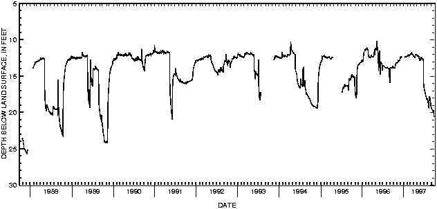

![]() U.S. Department of the Interior |
U.S. Geological Survey
U.S. Department of the Interior |
U.S. Geological Survey
URL: http://pubsdata.usgs.gov/pubs/wdr/1997/oh-97-2/sw97/410330081282000.html
Page Contact Information: GS Pubs Web Contact
Page Last Modified: Thursday, 25-Oct-2018 15:07:24 EDT
