Water Data Report 1997
						  Geauga County

					412518081221500. LOCAL NUMBER, GE-3A

LOCATION.--Lat 41025'18", long 81022'15", Hydrologic Unit 04110003, 1.2 miles southeast of Chagrin Falls.
   Owner: City of Chagrin Falls
AQUIFER.--Sandstone of Pennsylvanian Age.
WELL CHARACTERISTICS.--Drilled unused artesian well, diameter 6 in., depth drilled 120 ft, present depth 89 ft, cased.
INSTRUMENTATION.--Digital recorder--60 minute punch.
DATUM.--Elevation of land-surface datum is 1130 ft above sea level.
   Measuring point: Floor of instrument shelter 3.50 ft above sea level, from topographic map. Measuring point: Floor
of instrument shelter 3.0 ft above land-surface datum.
REMARKS.--Station operated by Ohio Department of Natural Resources, Division of Water. Water level affected by pumping
wells nearby for Chagrin Falls municipal supply.
PERIOD OF RECORD.--September 1951 to September 1991 continuous. Discontinued October 1991 to March 1996. Periodic
measurements April 1996 to September 1997. Continuous September 1997 to current year.
EXTREMES FOR PERIOD OF RECORD.--Maximum daily low, 52.85 ft below land-surface datum, Oct. 2, 1965;
   minimum daily low, 7.57 ft below land-surface datum, Apr. 22, 1991.


		DEPTH BELOW LAND SURFACE (WATER LEVEL) (FEET), WATER YEAR OCTOBER 1996 TO SEPTEMBER 1997
						DAILY MAXIMUM VALUES

 DAY       OCT      NOV      DEC      JAN      FEB      MAR      APR      MAY      JUN      JUL      AUG      SEP

   1       ---      ---      ---      ---      ---      ---      ---      ---      ---      ---      ---      ---
   2       ---      ---      ---      ---      ---      ---      ---      ---      ---      ---      ---      ---
   3       ---      ---      ---      ---      ---      ---      ---      ---      ---      ---      ---      ---
   4       ---      ---      ---      ---      ---      ---      ---      ---      ---      ---      ---      ---
   5       ---      ---      ---      ---      ---      ---      ---      ---      ---      ---      ---      ---

   6       ---      ---      ---      ---      ---      ---      ---      ---      ---      ---      ---      ---
   7       ---      ---      ---      ---      ---      ---      ---      ---      ---      ---      ---      ---
   8       ---      ---      ---      ---      ---      ---      ---      ---      ---      ---      ---      ---
   9       ---      ---      ---      ---      ---      ---      ---      ---      ---      ---      ---      ---
  10       ---      ---      ---      ---      ---      ---      ---      ---      ---      ---      ---      ---

  11       ---      ---      ---      ---      ---      ---      ---      ---      ---      ---      ---      ---
  12       ---      ---      ---      ---      ---      ---      ---      ---      ---      ---      ---      ---
  13       ---      ---      ---      ---      ---      ---      ---      ---      ---      ---      ---      ---
  14       ---      ---      ---      ---      ---      ---      ---      ---      ---      ---      ---      ---
  15       ---      ---      ---      ---      ---      ---      ---      ---      ---      ---      ---      ---

  16       ---      ---      ---      ---      ---      ---      ---      ---      ---      ---      ---      ---
  17       ---      ---      ---      ---      ---      ---      ---      ---      ---      ---      ---      ---
  18       ---      ---      ---      ---      ---      ---      ---      ---      ---      ---      ---      ---
  19       ---      ---      ---      ---      ---      ---      ---      ---      ---      ---      ---      ---
  20       ---      ---      ---      ---      ---      ---      ---      ---      ---      ---      ---      ---

  21       ---      ---      ---      ---      ---      ---      ---      ---      ---      ---      ---      ---
  22       ---      ---      ---      ---      ---      ---      ---      ---      ---      ---      ---      ---
  23       ---      ---      ---      ---      ---      ---      ---      ---      ---      ---      ---     8.52
  24       ---      ---      ---      ---      ---      ---      ---      ---      ---      ---      ---     8.54
  25       ---      ---      ---      ---      ---      ---      ---      ---      ---      ---      ---     8.16

  26       ---      ---      ---      ---      ---      ---      ---      ---      ---      ---      ---     8.43
  27       ---      ---      ---      ---      ---      ---      ---      ---      ---      ---      ---     8.43
  28       ---      ---      ---      ---      ---      ---      ---      ---      ---      ---      ---     8.24
  29       ---      ---      ---      ---      ---      ---      ---      ---      ---      ---      ---     7.90
  30       ---      ---      ---      ---      ---      ---      ---      ---      ---      ---      ---     8.18
  31       ---      ---      ---      ---      ---      ---      ---      ---      ---      ---      ---      ---

 MAX       ---      ---      ---      ---      ---      ---      ---      ---      ---      ---      ---     8.54

 WTR YR 1997   LOW 8.54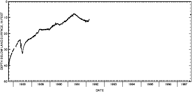

![]() U.S. Department of the Interior |
U.S. Geological Survey
U.S. Department of the Interior |
U.S. Geological Survey
URL: http://pubsdata.usgs.gov/pubs/wdr/1997/oh-97-2/sw97/412518081221500.html
Page Contact Information: GS Pubs Web Contact
Page Last Modified: Thursday, 25-Oct-2018 11:52:09 EDT
