Water Data Report 1997
					413704083362200. LOCAL NUMBER, LU-1


LOCATION.--Lat 41037'04", long 83036'22", Hydrologic Unit 04100001, at Toledo State Hospital.
   Owner: State of Ohio.
AQUIFER.--Limestone of Silurian Age.
WELL CHARACTERISTICS.--Drilled unused artesian well, diameter 12 in., depth drilled 525 ft, present depth 523.0 ft,
cased to 93 ft.
INSTRUMENTATION.--Type F continuous recorder.
DATUM.--Elevation of land-surface datum is 624 ft above sea level, from topographic map.
   Measuring point: Floor of instrument shelter 2.98 ft above land-surface datum (Revised from 1978 and 1979).
REMARKS.--Station operated by Ohio Department of Natural Resources, Division of Water. Prior to Aug. 23, 1978,
   measuring point was 3.10 ft above land-surface datum. Reported in 1979 as 3.00 ft above land-surface datum.
PERIOD OF RECORD.--March 1946 to September 1982 continuous, October 1983 to January 1985 periodic, continuous
   thereafter.
EXTREMES FOR PERIOD OF RECORD.--Maximum daily low, 117.25 ft below land-surface datum, Sept. 18, 1957;
   minimum daily low, 56.87 ft below land-surface datum, Apr. 16, 1987.


		DEPTH BELOW LAND SURFACE (WATER LEVEL) (FEET), WATER YEAR OCTOBER 1996 TO SEPTEMBER 1997
						DAILY MAXIMUM VALUES

 DAY       OCT      NOV      DEC      JAN      FEB      MAR      APR      MAY      JUN      JUL      AUG      SEP

   1     66.50    64.33    63.29    63.19    62.47    61.86    61.61    60.74    61.02    64.28    63.73    63.14
   2     66.33    64.44    63.55    62.69    62.59    61.97    61.61    60.77    61.30    64.28    63.71    63.21
   3     66.44    64.59    63.62    62.66    62.77    61.96    61.43    60.65    61.36    64.35    63.94    63.73
   4     66.42    64.59    63.85    62.66    62.67    61.84    61.29    60.84    61.53    64.54    64.02    63.98
   5     66.27    64.43    63.74    62.51    62.61    61.87    61.17    60.85    61.51    64.73    64.04    64.00

   6     66.04    64.39    63.26    62.86    62.61    62.07    60.94    60.88    61.34    64.83    64.04    63.73
   7     65.72    64.13    63.18    63.12    62.60    62.16    61.24    61.02    61.31    65.06    64.13    63.54
   8     65.50    64.02    63.20    63.14    62.63    62.19    61.43    60.85    61.29    65.00    63.99    63.40
   9     65.29    64.05    63.49    62.84    62.66    62.18    61.50    60.66    61.29    64.79    63.77    63.30
  10     65.56    64.18    63.43    62.29    62.55    61.75    61.51    60.75    61.26    64.87    63.59    63.68

  11     65.66    64.45    63.23    62.75    62.43    61.89    61.36    60.73    61.22    64.78    63.54    64.03
  12     65.51    64.65    63.29    63.10    62.67    62.04    61.04    60.36    61.41    64.45    63.73    64.10
  13     65.35    64.68    63.55    63.16    62.73    62.04    61.10    60.36    61.82    64.07    63.66    64.09
  14     65.33    64.71    63.64    63.15    62.25    61.54    61.25    60.36    62.36    63.72    63.86    63.90
  15     65.33    64.74    63.64    63.01    62.50    61.92    61.27    60.49    62.51    63.57    63.74    63.72

  16     65.02    64.51    63.34    62.63    62.68    62.03    61.11    60.65    62.45    63.75    63.56    63.54
  17     64.93    64.33    63.10    62.71    62.70    61.78    60.99    60.44    62.81    63.69    63.58    63.28
  18     64.76    64.14    63.21    62.79    62.32    61.88    60.94    60.45    62.75    63.50    63.57    63.30
  19     64.87    63.98    63.21    62.80    62.39    61.84    60.76    60.47    62.76    63.55    63.48    63.15
  20     64.76    63.95    63.49    62.83    62.42    61.42    60.78    60.64    62.90    63.46    63.25    63.26

  21     64.76    64.00    63.49    62.91    61.88    61.31    60.72    60.79    63.09    63.22    63.10    63.37
  22     64.74    64.11    63.28    62.51    62.24    61.43    60.69    60.85    63.48    63.09    63.09    63.26
  23     64.40    64.04    63.17    62.91    62.43    61.71    60.65    60.80    63.66    62.93    63.19    63.09
  24     64.65    63.94    63.21    62.88    62.52    61.82    60.81    60.63    63.64    62.91    63.13    63.11
  25     64.74    63.94    63.35    62.79    62.48    61.51    61.10    60.39    63.78    63.02    63.00    62.67

  26     64.87    64.13    63.38    62.99    62.01    61.43    61.19    60.62    63.99    62.85    62.94    62.86
  27     64.85    64.30    63.23    62.85    61.95    61.24    61.06    60.74    64.14    62.78    62.79    62.85
  28     64.68    64.18    62.93    62.98    62.09    61.16    60.70    60.74    64.18    62.96    62.77    62.59
  29     64.60    64.00    63.14    63.12      ---    61.17    60.73    60.61    64.20    63.33    63.12    62.33
  30     64.33    63.68    63.21    62.86      ---    61.20    60.62    60.47    64.30    63.59    63.14    62.54
  31     64.38      ---    63.29    62.35      ---    61.47      ---    60.74      ---    63.80    63.06      ---

 MAX     66.50    64.74    63.85    63.19    62.77    62.19    61.61    61.02    64.30    65.06    64.13    64.10

 CAL YR 1996   LOW 67.96
 WTR YR 1997   LOW 66.50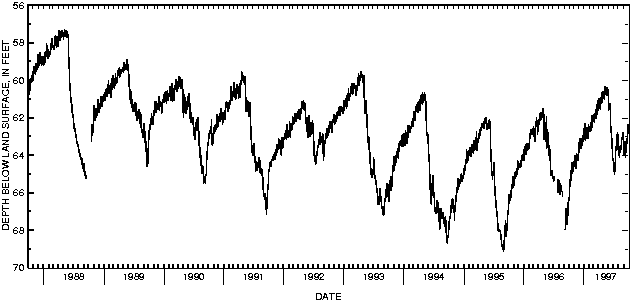

![]() U.S. Department of the Interior |
U.S. Geological Survey
U.S. Department of the Interior |
U.S. Geological Survey
URL: http://pubsdata.usgs.gov/pubs/wdr/1997/oh-97-2/sw97/413704083362200.html
Page Contact Information: GS Pubs Web Contact
Page Last Modified: Thursday, 25-Oct-2018 14:16:35 EDT
