Water Data Report 1997
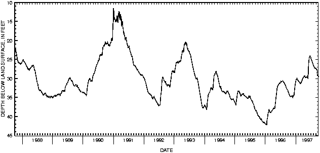
405303082170700 LOCAL NUMBER AS-2
LOCATION.--Lat 40053'03", long 82017'07", Hydrologic Unit 05040002, Jerome Fork well field 2 mi northeast of Ashland.
Owner: Ashland Water Department.
AQUIFER.--Sand and gravel of Pleistocene Age.
WELL CHARACTERISTICS.--Drilled test water table well, diameter 6 in., depth 64 ft, cased.
INSTRUMENTATION.--Digital recorder--60 minute punch.
DATUM.--Elevation of land-surface datum is 980 ft above sea level, from topographic map.
Measuring point: Floor of instrument shelter 2.00 ft above land-surface datum.
REMARKS.--Station operated by Ohio Department of Natural Resources, Division of Water.
PERIOD OF RECORD.--March 1964 to current year.
EXTREMES FOR PERIOD OF RECORD.--Maximum daily low, 42.25 ft below land-surface datum, Jan. 17-18, 1996;
minimum daily low, 11.56 ft below land-surface datum, Jan. 1, 1991.
DEPTH BELOW LAND SURFACE (WATER LEVEL) (FEET), WATER YEAR OCTOBER 1996 TO SEPTEMBER 1997
DAILY MAXIMUM VALUES
DAY OCT NOV DEC JAN FEB MAR APR MAY JUN JUL AUG SEP
1 33.37 34.79 34.67 30.77 30.61 31.17 29.79 29.79 28.54 24.51 26.58 27.32
2 33.50 34.82 34.67 30.64 30.67 31.19 29.77 29.79 27.53 24.57 26.64 27.32
3 33.56 34.84 34.62 30.53 30.72 31.15 29.73 29.68 26.96 24.70 26.67 27.34
4 33.64 34.83 34.64 30.47 30.72 31.13 29.68 29.68 26.58 24.83 26.69 27.37
5 33.65 34.79 34.52 30.32 30.76 31.12 29.62 29.62 26.22 24.90 26.70 27.39
6 33.67 34.79 34.49 30.30 30.79 31.08 29.56 29.58 25.93 24.95 26.74 27.42
7 33.72 34.75 34.44 30.25 30.82 31.09 29.56 29.61 25.70 25.06 26.79 27.46
8 33.77 34.74 34.39 30.24 30.87 31.00 29.51 29.58 25.43 25.09 26.83 27.55
9 33.86 34.69 34.44 30.14 30.88 30.97 29.49 29.62 25.17 25.13 26.87 27.63
10 33.94 34.69 34.40 30.14 30.89 30.88 29.45 29.66 24.95 25.16 26.92 27.79
11 34.00 34.69 34.34 30.15 30.87 30.83 29.40 29.65 24.73 25.17 26.98 27.91
12 34.06 34.69 34.26 30.14 30.91 30.81 29.33 29.55 24.58 25.18 26.99 28.06
13 34.09 34.68 33.97 30.09 30.91 30.76 29.34 29.55 24.42 25.25 27.06 28.17
14 34.16 34.63 33.72 30.06 30.86 30.69 29.35 29.52 24.34 25.33 27.08 28.30
15 34.19 34.64 33.58 30.00 30.97 30.70 29.33 29.53 24.28 25.43 27.13 28.44
16 34.24 34.61 33.38 30.07 31.04 30.64 29.28 29.57 24.15 25.46 27.23 28.54
17 34.28 34.59 33.17 30.07 31.04 30.56 29.28 29.52 24.16 25.47 27.22 28.67
18 34.34 34.56 33.04 30.09 31.08 30.52 29.28 29.52 24.09 25.56 27.30 28.80
19 34.35 34.68 32.71 30.08 31.20 30.44 29.33 29.65 24.08 25.64 27.34 28.93
20 34.41 34.77 32.50 30.20 31.19 30.31 29.42 29.67 24.04 25.69 27.36 29.10
21 34.49 34.85 32.34 30.22 31.19 30.25 29.49 29.74 24.02 25.76 27.36 29.19
22 34.51 34.87 32.13 30.26 31.34 30.29 29.56 29.83 24.05 25.83 27.38 29.27
23 34.58 34.87 31.97 30.35 31.32 30.24 29.62 29.90 24.10 25.89 27.39 29.33
24 34.62 34.89 31.73 30.34 31.35 30.21 29.71 29.95 24.14 25.98 27.39 29.37
25 34.67 34.95 31.68 30.42 31.34 30.08 29.78 29.96 24.17 26.05 27.37 29.40
26 34.70 35.00 31.48 30.44 31.25 30.03 29.81 29.69 24.18 26.15 27.37 29.45
27 34.72 34.92 31.29 30.42 31.27 29.95 29.81 29.22 24.26 26.23 27.33 29.44
28 34.74 34.74 31.13 30.50 31.28 29.89 29.86 29.13 24.36 26.32 27.29 29.41
29 34.74 34.75 31.05 30.51 --- 29.80 29.86 29.05 24.40 26.41 27.30 29.40
30 34.79 34.71 30.99 30.43 --- 29.77 29.81 29.00 24.46 26.49 27.29 29.48
31 34.79 --- 30.85 30.50 --- 29.78 --- 28.84 --- 26.54 27.31 ---
MAX 34.79 35.00 34.67 30.77 31.35 31.19 29.86 29.96 28.54 26.54 27.39 29.48
CAL YR 1996 LOW 42.25
WTR YR 1997 LOW 35.00
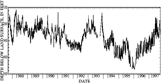
 405425082173000 Local number AS-3
LOCATION.--Lat 40054'25", long 82017'30", Hydrologic Unit 05040002, Ashland Bates well field along Jerome Fork
near Ashland.
Owner: Ashland Water Department.
AQUIFER.--Sand and gravel of Pleistocene Age.
WELL CHARACTERISTICS.--Drilled unused artesian well, diameter 8 in., depth 78 ft, cased.
INSTRUMENTATION.--Digital recorder--60-minute punch.
DATUM.--Elevation of land-surface datum is 990 ft above sea level, from topographic map.
Measuring point: Floor of instrument shelter 5.00 ft above land-surface datum.
REMARKS.--Station operated by Ohio Department of Natural Resources, Division of Water.
PERIOD OF RECORD.--August 1974 to current year.
EXTREMES FOR PERIOD OF RECORD.--Maximum daily low, 47.29 ft below land-surface datum, Jan. 17, 1996;
minimum daily low, 3.10 ft, above land-surface, Feb. 23, 1978.
DEPTH BELOW LAND SURFACE (WATER LEVEL) (FEET), WATER YEAR OCTOBER 1996 TO SEPTEMBER 1997
DAILY MAXIMUM VALUES
DAY OCT NOV DEC JAN FEB MAR APR MAY JUN JUL AUG SEP
1 33.23 29.26 31.36 28.85 37.00 35.30 25.46 29.78 18.67 24.48 21.70 22.63
2 33.88 29.11 31.44 28.41 37.16 30.26 25.09 30.24 16.76 24.73 21.83 22.30
3 34.38 29.01 31.42 27.99 37.16 28.65 30.32 31.08 16.37 18.99 21.70 22.41
4 34.80 28.87 31.37 27.66 37.02 27.64 31.07 31.75 16.06 17.66 21.45 22.33
5 35.16 33.34 35.32 30.67 34.89 26.89 31.56 32.03 15.64 16.86 26.07 22.15
6 35.41 34.33 34.36 26.67 33.84 26.24 31.98 32.53 15.50 16.13 26.42 21.75
7 35.64 34.94 31.71 30.22 29.95 28.09 32.52 32.70 23.90 16.68 26.27 21.19
8 35.85 35.44 31.65 30.52 33.04 24.83 33.06 32.79 25.70 17.51 26.67 20.67
9 36.17 36.07 31.59 26.63 32.97 24.67 33.37 27.20 26.14 18.32 27.03 20.10
10 36.30 36.66 31.24 30.55 33.18 29.05 31.83 26.38 26.25 18.84 27.32 19.50
11 36.50 37.13 30.96 26.75 33.19 30.31 26.81 25.86 18.98 19.24 27.63 19.16
12 36.77 37.53 30.63 31.97 32.86 30.82 25.86 25.41 16.91 24.18 27.74 18.77
13 36.99 37.80 30.40 32.78 32.68 31.00 25.10 25.02 16.44 25.74 27.65 18.44
14 37.14 33.84 34.00 31.55 28.86 31.44 24.76 24.72 16.48 26.17 27.59 18.04
15 37.28 34.29 33.68 31.17 32.57 31.70 24.44 24.46 16.46 26.18 27.66 17.61
16 37.35 31.96 29.45 31.14 32.63 25.86 24.18 24.51 23.18 24.82 27.95 17.95
17 31.90 31.51 29.29 27.58 32.56 29.90 23.97 24.72 24.63 26.09 28.05 22.78
18 31.04 31.07 33.47 27.80 28.56 30.54 23.75 24.76 26.00 26.77 28.32 23.56
19 30.86 30.83 31.16 31.49 32.06 30.82 23.54 24.56 26.78 27.36 28.46 23.76
20 30.83 30.81 34.61 27.60 33.11 31.07 23.42 24.16 27.37 27.65 28.51 24.17
21 30.86 31.36 35.30 31.45 34.01 31.19 23.24 23.63 27.93 23.24 24.92 24.32
22 30.87 34.55 35.63 27.38 34.57 31.60 23.11 23.18 28.52 26.88 27.07 24.53
23 36.06 31.50 36.02 33.33 34.82 31.80 23.06 22.80 28.82 27.11 27.65 25.10
24 37.06 31.31 36.40 34.07 34.91 31.92 23.01 22.26 23.10 26.05 27.72 25.46
25 37.38 31.39 36.43 34.65 35.00 32.21 22.98 21.76 22.07 26.68 27.77 25.91
26 35.65 31.58 31.97 34.83 35.07 32.62 22.92 19.90 21.21 26.75 27.77 26.14
27 31.52 35.35 30.56 35.27 35.33 33.04 22.79 19.99 20.19 22.75 27.73 22.91
28 30.54 31.40 30.01 35.70 35.30 33.16 27.46 26.04 19.19 22.20 27.72 22.30
29 29.95 31.39 29.67 36.01 --- 27.24 28.59 26.75 18.26 21.93 27.72 21.94
30 29.54 31.19 29.57 36.32 --- 26.63 29.20 20.34 23.03 21.94 23.92 21.44
31 29.44 --- 29.19 36.68 --- 26.02 --- 19.54 --- 21.57 23.16 ---
MAX 37.38 37.80 36.43 36.68 37.16 35.30 33.37 32.79 28.82 27.65 28.51 26.14
CAL YR 1996 LOW 47.29
WTR YR 1997 LOW 37.80
405425082173000 Local number AS-3
LOCATION.--Lat 40054'25", long 82017'30", Hydrologic Unit 05040002, Ashland Bates well field along Jerome Fork
near Ashland.
Owner: Ashland Water Department.
AQUIFER.--Sand and gravel of Pleistocene Age.
WELL CHARACTERISTICS.--Drilled unused artesian well, diameter 8 in., depth 78 ft, cased.
INSTRUMENTATION.--Digital recorder--60-minute punch.
DATUM.--Elevation of land-surface datum is 990 ft above sea level, from topographic map.
Measuring point: Floor of instrument shelter 5.00 ft above land-surface datum.
REMARKS.--Station operated by Ohio Department of Natural Resources, Division of Water.
PERIOD OF RECORD.--August 1974 to current year.
EXTREMES FOR PERIOD OF RECORD.--Maximum daily low, 47.29 ft below land-surface datum, Jan. 17, 1996;
minimum daily low, 3.10 ft, above land-surface, Feb. 23, 1978.
DEPTH BELOW LAND SURFACE (WATER LEVEL) (FEET), WATER YEAR OCTOBER 1996 TO SEPTEMBER 1997
DAILY MAXIMUM VALUES
DAY OCT NOV DEC JAN FEB MAR APR MAY JUN JUL AUG SEP
1 33.23 29.26 31.36 28.85 37.00 35.30 25.46 29.78 18.67 24.48 21.70 22.63
2 33.88 29.11 31.44 28.41 37.16 30.26 25.09 30.24 16.76 24.73 21.83 22.30
3 34.38 29.01 31.42 27.99 37.16 28.65 30.32 31.08 16.37 18.99 21.70 22.41
4 34.80 28.87 31.37 27.66 37.02 27.64 31.07 31.75 16.06 17.66 21.45 22.33
5 35.16 33.34 35.32 30.67 34.89 26.89 31.56 32.03 15.64 16.86 26.07 22.15
6 35.41 34.33 34.36 26.67 33.84 26.24 31.98 32.53 15.50 16.13 26.42 21.75
7 35.64 34.94 31.71 30.22 29.95 28.09 32.52 32.70 23.90 16.68 26.27 21.19
8 35.85 35.44 31.65 30.52 33.04 24.83 33.06 32.79 25.70 17.51 26.67 20.67
9 36.17 36.07 31.59 26.63 32.97 24.67 33.37 27.20 26.14 18.32 27.03 20.10
10 36.30 36.66 31.24 30.55 33.18 29.05 31.83 26.38 26.25 18.84 27.32 19.50
11 36.50 37.13 30.96 26.75 33.19 30.31 26.81 25.86 18.98 19.24 27.63 19.16
12 36.77 37.53 30.63 31.97 32.86 30.82 25.86 25.41 16.91 24.18 27.74 18.77
13 36.99 37.80 30.40 32.78 32.68 31.00 25.10 25.02 16.44 25.74 27.65 18.44
14 37.14 33.84 34.00 31.55 28.86 31.44 24.76 24.72 16.48 26.17 27.59 18.04
15 37.28 34.29 33.68 31.17 32.57 31.70 24.44 24.46 16.46 26.18 27.66 17.61
16 37.35 31.96 29.45 31.14 32.63 25.86 24.18 24.51 23.18 24.82 27.95 17.95
17 31.90 31.51 29.29 27.58 32.56 29.90 23.97 24.72 24.63 26.09 28.05 22.78
18 31.04 31.07 33.47 27.80 28.56 30.54 23.75 24.76 26.00 26.77 28.32 23.56
19 30.86 30.83 31.16 31.49 32.06 30.82 23.54 24.56 26.78 27.36 28.46 23.76
20 30.83 30.81 34.61 27.60 33.11 31.07 23.42 24.16 27.37 27.65 28.51 24.17
21 30.86 31.36 35.30 31.45 34.01 31.19 23.24 23.63 27.93 23.24 24.92 24.32
22 30.87 34.55 35.63 27.38 34.57 31.60 23.11 23.18 28.52 26.88 27.07 24.53
23 36.06 31.50 36.02 33.33 34.82 31.80 23.06 22.80 28.82 27.11 27.65 25.10
24 37.06 31.31 36.40 34.07 34.91 31.92 23.01 22.26 23.10 26.05 27.72 25.46
25 37.38 31.39 36.43 34.65 35.00 32.21 22.98 21.76 22.07 26.68 27.77 25.91
26 35.65 31.58 31.97 34.83 35.07 32.62 22.92 19.90 21.21 26.75 27.77 26.14
27 31.52 35.35 30.56 35.27 35.33 33.04 22.79 19.99 20.19 22.75 27.73 22.91
28 30.54 31.40 30.01 35.70 35.30 33.16 27.46 26.04 19.19 22.20 27.72 22.30
29 29.95 31.39 29.67 36.01 --- 27.24 28.59 26.75 18.26 21.93 27.72 21.94
30 29.54 31.19 29.57 36.32 --- 26.63 29.20 20.34 23.03 21.94 23.92 21.44
31 29.44 --- 29.19 36.68 --- 26.02 --- 19.54 --- 21.57 23.16 ---
MAX 37.38 37.80 36.43 36.68 37.16 35.30 33.37 32.79 28.82 27.65 28.51 26.14
CAL YR 1996 LOW 47.29
WTR YR 1997 LOW 37.80

![]() U.S. Department of the Interior |
U.S. Geological Survey
U.S. Department of the Interior |
U.S. Geological Survey
URL: http://pubsdata.usgs.gov/pubs/wdr/1997/oh-97-2/sw97/ashland.html
Page Contact Information: GS Pubs Web Contact
Page Last Modified: Friday, 09-Nov-2018 10:25:34 EST
