Water Data Report 1997
				385932083412400. LOCAL NUMBER, BR-20


LOCATION.--Lat 38059'32", long 83041'24", Hydrologic Unit 05090201, near Fincastle.
   Owner: Davon Inc.
AQUIFER.--Limestone of Silurian Age.
WELL CHARACTERISTICS.--Drilled observation well, diameter 6 in., depth 40 ft, cased to 25 ft.
INSTRUMENTATION.--Digital recorder--60-minute punch.
DATUM.--Elevation of land-surface datum is 1,026.27 ft above sea level.
   Measuring point: Floor of instrument shelter, 3.00 ft above land-surface datum.
REMARKS.--Station operated by Ohio Department of Natural Resources, Division of Water.
PERIOD OF RECORD.--March 1993 to current year.
EXTREMES FOR PERIOD OF RECORD.--Maximum daily low, 24.73 ft below land-surface datum, July 24-31, 1996;
   minimum daily low, 22.00 ft below land-surface datum, Aug. 29, 1997.


	DEPTH BELOW LAND SURFACE (WATER LEVEL) (FEET), WATER YEAR OCTOBER 1996 TO SEPTEMBER 1997
					DAILY MAXIMUM VALUES

 DAY       OCT      NOV      DEC      JAN      FEB      MAR      APR      MAY      JUN      JUL      AUG      SEP

   1     24.14    23.64    23.60    23.54    23.72    23.75    23.74    23.94    23.89    23.74    22.56    22.03
   2     24.12    23.64    23.58    23.54    23.72    23.71    23.78    23.95    23.87    23.73    22.50    22.04
   3     24.08    23.64    23.57    23.54    23.73    23.69    23.79    23.95    23.85    23.73    22.44    22.04
   4     24.06    23.64    23.56    23.54    23.72    23.67    23.79    23.95    23.83    23.72    22.38    22.05
   5     24.04    23.64    23.56    23.54    23.71    23.66    23.80    23.95    23.83    23.72    22.32    22.06

   6     24.02    23.65    23.56    23.54    23.71    23.65    23.80    23.95    23.82    23.72    22.28    22.06
   7     23.99    23.65    23.55    23.54    23.70    23.64    23.81    23.95    23.81    23.72    22.27    22.06
   8     23.97    23.64    23.55    23.54    23.70    23.64    23.82    23.95    23.81    23.71    22.27    22.06
   9     23.94    23.64    23.54    23.54    23.70    23.64    23.83    23.95    23.80    23.70    22.26    22.06
  10     23.92    23.63    23.54    23.54    23.70    23.64    23.84    23.95    23.80    23.68    22.25    22.05

  11     23.90    23.62    23.54    23.54    23.70    23.64    23.85    23.94    23.80    23.66    22.24    22.04
  12     23.89    23.63    23.54    23.55    23.70    23.65    23.86    23.94    23.80    23.64    22.23    22.06
  13     23.88    23.63    23.54    23.57    23.70    23.65    23.86    23.93    23.79    23.62    22.22    22.07
  14     23.86    23.63    23.54    23.58    23.70    23.65    23.88    23.93    23.78      ---    22.19    22.09
  15     23.85    23.64    23.55    23.58    23.71    23.65    23.89    23.93    23.78      ---    22.16    22.10

  16     23.84    23.64    23.55    23.59    23.71    23.65    23.89    23.93    23.78      ---    22.13    22.11
  17     23.82    23.64    23.55    23.62    23.72    23.66    23.90    23.93    23.78      ---    22.11    22.11
  18     23.81    23.64    23.54    23.63    23.72    23.66    23.91    23.93    23.77      ---    22.10    22.13
  19     23.79    23.64    23.53    23.65    23.73    23.66    23.91    23.93    23.76      ---    22.09    22.14
  20     23.78    23.63    23.53    23.67    23.73    23.66    23.92    23.93    23.75      ---    22.08    22.14

  21     23.76    23.63    23.53    23.68    23.73    23.66    23.92    23.92    23.75      ---    22.04    22.17
  22     23.75    23.63    23.53    23.69    23.73    23.66    23.92    23.92    23.74      ---    22.02    22.18
  23     23.74    23.63    23.53    23.70    23.74    23.67    23.92    23.92    23.74      ---    22.02    22.20
  24     23.72    23.63    23.53    23.70    23.75    23.68    23.92    23.92    23.74      ---    22.03    22.21
  25     23.71    23.63    23.53    23.71    23.75    23.69    23.93    23.92    23.74      ---    22.03    22.21

  26     23.70    23.62    23.53    23.71    23.75    23.69    23.94    23.92    23.74    23.54    22.02    22.21
  27     23.70    23.62    23.53    23.71    23.75    23.69    23.94    23.91    23.74    23.25    22.02    22.22
  28     23.69    23.62    23.53    23.72    23.76    23.70    23.94    23.91    23.74    23.01    22.01    22.22
  29     23.67    23.62    23.53    23.72      ---    23.70    23.94    23.91    23.74    22.82    22.00    22.22
  30     23.66    23.61    23.54    23.72      ---    23.71    23.94    23.90    23.74    22.70    22.01    22.21
  31     23.65      ---    23.54    23.72      ---    23.72      ---    23.90      ---    22.62    22.01      ---

 MAX     24.14    23.65    23.60    23.72    23.76    23.75    23.94    23.95    23.89    23.74    22.56    22.22

 CAL YR 1996   LOW 24.73
 WTR YR 1997   LOW 24.14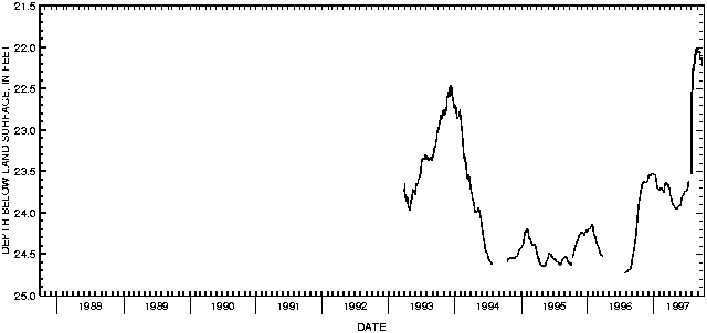

![]() U.S. Department of the Interior |
U.S. Geological Survey
U.S. Department of the Interior |
U.S. Geological Survey
URL: http://pubsdata.usgs.gov/pubs/wdr/1997/oh-97-2/sw97/brown.html
Page Contact Information: GS Pubs Web Contact
Page Last Modified: Friday, 09-Nov-2018 10:25:33 EST
