Water Data Report 1997
394956083002700. LOCAL NUMBER, FR-18 LOCATION.--Lat 39049'56", long 83000'27", Hydrologic Unit 05060001, south of State Rt. 665 at Shadeville. Owner: City of Columbus. AQUIFER.--Sand and gravel of Pleistocene Age. WELL CHARACTERISTICS.--Drilled test water table well, diameter 6 in., depth 86.4 ft, cased. INSTRUMENTATION.--Type F continuous recorder. DATUM.--Elevation of land-surface datum is 690 ft above sea level, from topographic map. Measuring point: Floor of instrument shelter 3.80 ft above land-surface datum. REMARKS.--Station operated by Ohio Department of Natural Resources, Division of Water. PERIOD OF RECORD.--November 22, 1985, to March 26, 1986, periodic, continuous thereafter. EXTREMES FOR PERIOD OF RECORD.--Maximum daily low, 33.15 ft below land-surface datum, Feb. 19-22, 1992; minimum daily low, 6.74 ft below land-surface datum, June 4, 1997. DEPTH BELOW LAND SURFACE (WATER LEVEL) (FEET), WATER YEAR OCTOBER 1996 TO SEPTEMBER 1997 DAILY MAXIMUM VALUES DAY OCT NOV DEC JAN FEB MAR APR MAY JUN JUL AUG SEP 1 20.21 20.60 19.25 15.17 16.33 16.42 15.11 16.96 17.09 15.17 18.58 19.92 2 20.22 20.64 18.78 15.23 16.37 16.35 15.22 17.00 13.40 15.26 18.69 20.03 3 20.22 20.67 18.15 15.29 16.41 15.15 15.32 16.93 7.00 15.38 18.79 20.13 4 20.23 20.70 18.08 15.37 16.43 14.60 15.41 16.70 6.74 15.51 18.82 20.23 5 20.25 20.73 18.07 15.38 16.30 14.63 15.49 16.72 7.21 15.65 18.86 20.33 6 20.26 20.76 18.05 15.45 15.65 14.65 15.58 16.72 7.88 15.77 18.95 20.43 7 20.28 20.77 18.10 15.52 14.95 14.65 15.68 16.73 8.47 15.92 19.04 20.52 8 20.29 20.69 18.17 15.58 14.60 14.25 15.77 16.75 8.95 16.06 19.14 20.60 9 20.30 20.66 18.25 15.63 14.57 13.78 15.88 16.65 9.45 16.17 19.26 20.68 10 20.30 20.66 18.32 15.71 14.65 13.64 15.97 16.68 9.90 16.31 19.36 20.75 11 20.32 20.68 18.38 15.80 14.75 13.53 16.05 16.73 10.32 16.44 19.45 20.83 12 20.33 20.71 18.41 15.90 14.85 13.50 16.10 16.78 10.80 16.58 19.53 20.91 13 20.36 20.75 18.41 16.00 14.98 13.57 16.09 16.84 11.25 16.70 19.47 20.99 14 20.38 20.79 18.41 16.11 15.10 13.60 16.16 16.89 11.75 16.83 19.41 21.06 15 20.40 20.83 17.90 16.20 15.23 13.60 16.22 16.94 12.25 16.96 19.45 21.14 16 20.42 20.87 17.51 16.28 15.36 13.65 16.28 17.01 12.72 17.08 19.44 21.21 17 20.44 20.90 17.35 16.38 15.49 13.70 16.33 17.08 12.77 17.20 19.44 21.29 18 20.46 20.90 16.85 16.48 15.62 13.74 16.38 17.16 12.86 17.31 18.80 21.37 19 20.41 20.92 15.78 16.56 15.76 13.74 16.44 17.24 12.75 17.43 18.67 21.44 20 20.42 20.95 15.18 16.65 15.90 13.84 16.50 17.30 12.99 17.55 18.68 21.50 21 20.44 20.98 15.02 16.73 16.00 13.96 16.57 17.36 13.27 17.69 18.43 21.58 22 20.46 21.02 15.07 16.75 16.08 14.10 16.64 17.42 13.53 17.81 18.49 21.66 23 20.47 21.05 15.10 16.79 16.14 14.24 16.72 17.46 13.79 17.87 18.62 21.73 24 20.48 21.08 14.98 16.80 16.20 14.37 16.78 17.53 14.03 17.97 18.78 21.79 25 20.50 21.10 14.94 16.59 16.26 14.45 16.85 17.55 14.26 18.08 18.94 21.85 26 20.52 20.88 14.95 16.61 16.32 14.53 16.92 17.41 14.49 18.18 19.11 21.91 27 20.52 20.76 14.97 16.62 16.38 14.66 16.97 17.44 14.68 18.17 19.27 21.96 28 20.53 20.15 14.99 16.29 16.41 14.77 16.90 17.44 14.87 18.19 19.42 22.01 29 20.54 19.68 15.03 16.29 --- 14.85 16.90 17.44 15.05 18.27 19.54 22.07 30 20.57 19.49 15.07 16.29 --- 14.95 16.95 17.30 15.17 18.35 19.67 22.11 31 20.58 --- 15.12 16.30 --- 15.02 --- 17.31 --- 18.50 19.80 --- MAX 20.58 21.10 19.25 16.80 16.43 16.42 16.97 17.55 17.09 18.50 19.80 22.11 CAL YR 1996 LOW 26.45 WTR YR 1997 LOW 22.11395118082573300. LOCAL NUMBER, FR-3 LOCATION.--Lat 39051'14", long 82057'32", Hydrologic Unit 05060001, 0.7 mi southwest of Rees. Owner: R. Hann. AQUIFER.--Sand and gravel of Pleistocene Age. CHARACTERISTICS.--Drilled test water table well, diameter 12 in., depth drilled 60 ft, present depth 53 ft, cased. INSTRUMENTATION.--Type F continuous recorder. DATUM.--Elevation of land-surface datum is 712.94 ft above sea level. Measuring point: Floor of instrument shelter 3.43 ft above land-surface datum. REMARKS.--Station operated by Ohio Department of Natural Resources, Division of Water. PERIOD OF RECORD.--April 1946 to September 1982 continuous, periodic October 1982 to September 1989, continuous thereafter. EXTREMES FOR PERIOD OF RECORD.--Maximum daily low, 20.75 ft below land-surface datum, July 7, 1966; minimum daily low, 0.0 ft below land-surface datum, Jan. 22, 1959. DEPTH BELOW LAND SURFACE (WATER LEVEL) (FEET), WATER YEAR OCTOBER 1996 TO SEPTEMBER 1997 DAILY MAXIMUM VALUES DAY OCT NOV DEC JAN FEB MAR APR MAY JUN JUL AUG SEP 1 11.66 12.04 11.60 11.13 11.20 11.12 --- 12.05 11.70 11.14 11.74 11.64 2 11.82 12.08 10.75 11.17 11.37 11.00 --- 12.05 6.65 10.94 11.80 11.68 3 11.96 12.12 10.88 11.38 11.49 9.10 --- 12.05 5.70 10.96 11.87 11.75 4 12.05 12.13 11.01 11.52 11.49 9.80 --- 11.55 7.00 11.12 11.89 11.79 5 12.12 12.13 11.03 11.57 10.78 10.02 --- 11.53 9.05 11.25 11.64 11.83 6 12.16 12.13 11.08 11.53 9.61 10.14 --- 11.66 9.43 11.37 11.79 11.86 7 12.19 12.11 11.33 11.66 9.36 9.93 --- 11.78 9.37 11.48 11.89 11.89 8 12.22 --- 11.55 11.71 9.90 9.54 --- 11.85 9.42 11.54 11.96 11.93 9 12.26 --- 11.74 11.72 10.31 9.77 --- 11.80 9.53 11.58 12.02 11.95 10 12.27 --- 11.82 11.77 10.58 9.77 --- 11.75 9.61 11.57 12.06 11.95 11 12.28 --- 11.92 11.89 10.77 9.40 --- 11.83 9.89 11.63 12.07 11.94 12 12.32 --- 11.95 11.94 10.92 9.68 --- 11.91 10.20 11.68 12.06 11.79 13 12.35 --- 11.91 11.99 10.98 9.97 --- 11.97 10.35 11.76 12.07 11.87 14 12.37 --- 11.84 12.01 11.08 10.00 --- 12.00 10.04 11.82 11.72 11.94 15 12.39 --- 11.86 12.02 11.25 9.55 --- 12.00 10.55 11.87 11.81 11.98 16 12.26 --- 11.88 11.97 11.40 9.53 --- 11.92 10.89 11.92 11.74 12.00 17 12.26 --- 11.87 11.93 11.53 9.87 --- 12.01 10.80 11.97 11.68 12.04 18 12.27 --- 10.59 12.02 11.58 9.90 --- 12.05 9.35 12.00 10.25 12.08 19 12.27 --- 10.50 12.07 11.63 9.85 --- 12.05 8.50 11.98 9.87 12.08 20 12.09 --- 10.51 12.11 11.63 10.07 --- 12.01 9.12 11.94 10.07 12.09 21 12.17 --- 10.82 12.14 11.58 10.45 --- 12.07 9.80 12.00 9.95 12.05 22 12.19 --- 11.08 12.11 11.50 10.75 --- 12.12 10.25 12.01 10.00 12.10 23 12.17 --- 11.18 12.00 11.33 10.98 --- 12.17 10.53 11.89 10.36 12.13 24 12.10 --- 11.15 11.73 11.48 11.10 --- 12.20 10.80 11.65 10.62 12.15 25 12.06 --- 10.34 11.68 11.52 11.20 --- 12.21 11.02 11.74 10.84 12.13 26 12.09 --- 10.50 11.33 11.53 11.21 --- 12.05 11.14 11.85 10.99 12.17 27 12.10 11.55 10.52 11.45 11.52 11.24 --- 11.78 11.25 11.88 11.14 12.19 28 12.08 11.70 10.67 11.33 11.45 11.30 --- 11.78 11.38 11.00 11.27 12.20 29 12.08 11.80 10.87 10.52 --- 11.30 --- 11.92 11.47 11.24 11.44 12.20 30 12.08 11.82 11.00 10.60 --- 11.31 12.01 11.92 11.47 11.46 11.51 12.25 31 12.10 --- 11.10 10.97 --- 11.31 --- 11.96 --- 11.64 11.58 --- MAX 12.39 12.13 11.95 12.14 11.63 11.31 12.01 12.21 11.70 12.01 12.07 12.25 CAL YR 1996 LOW 12.47 WTR YR 1997 LOW 12.39
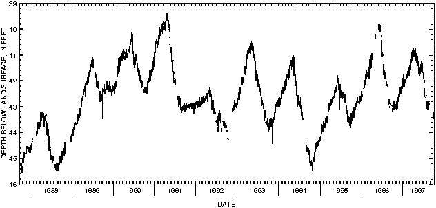
400101083021800. LOCAL NUMBER, FR-10 LOCATION.--Lat 40001'01", long 83002'18", Hydrologic Unit 05060001, Kenny and Ackerman Roads, Columbus. Owner: Ohio State University. AQUIFER.--Sand and gravel of Pleistocene Age. WELL CHARACTERISTICS.--Drilled test artesian well, diameter 4 in., depth 75 ft, cased. INSTRUMENTATION.--Type F continuous recorder. DATUM.--Elevation of land-surface datum is 775 ft above sea level, from topographic map. Measuring point: Floor of instrument shelter 4.00 ft above land-surface datum. REMARKS.--Station operated by Ohio Department of Natural Resources, Division of Water. PERIOD OF RECORD.--March 1944 to current year. EXTREMES FOR PERIOD OF RECORD.--Maximum daily low, 48.20 ft below land-surface datum, Oct. 7, 1954; minimum daily low, 37.76 ft below land-surface datum, Apr. 13, 1951. DEPTH BELOW LAND SURFACE (WATER LEVEL) (FEET), WATER YEAR OCTOBER 1996 TO SEPTEMBER 1997 DAILY MAXIMUM VALUES DAY OCT NOV DEC JAN FEB MAR APR MAY JUN JUL AUG SEP 1 43.03 42.90 42.38 42.13 41.75 41.49 41.06 40.93 41.47 41.90 42.87 --- 2 43.01 42.89 42.45 41.95 41.85 41.48 41.09 41.10 41.48 41.90 42.83 --- 3 43.20 43.06 42.62 41.89 41.90 41.45 41.04 40.96 41.50 41.83 43.07 --- 4 43.20 43.09 42.62 41.88 41.75 41.40 40.93 41.11 41.54 41.84 42.80 --- 5 43.15 43.03 42.48 41.89 41.87 41.40 40.88 41.15 41.57 --- 42.79 --- 6 43.10 42.93 42.28 42.05 41.86 41.47 40.75 41.19 41.55 41.93 42.87 --- 7 42.95 42.82 42.27 42.13 41.80 41.57 40.95 41.35 41.61 --- 42.92 --- 8 42.81 42.76 42.38 42.12 41.81 41.55 41.01 41.18 41.72 42.10 42.94 --- 9 42.78 42.87 42.43 41.72 41.82 41.55 41.06 41.08 41.55 41.96 42.92 --- 10 42.95 43.02 42.33 41.90 41.78 41.33 41.06 41.19 41.64 42.05 42.92 --- 11 42.95 43.10 42.30 42.10 41.73 41.29 41.00 41.22 41.57 --- 43.00 --- 12 42.95 43.10 42.40 42.19 41.81 41.39 40.79 41.07 41.37 42.29 43.10 --- 13 42.95 43.06 42.50 42.20 41.84 41.39 40.87 41.08 41.29 42.34 42.94 --- 14 43.06 43.03 --- 42.20 41.61 41.28 40.97 41.12 41.29 42.36 43.00 --- 15 43.11 43.03 42.50 42.00 41.76 --- 40.99 41.21 41.46 42.38 43.10 --- 16 43.00 42.99 42.37 41.97 41.83 --- 40.95 41.42 41.31 42.62 42.88 --- 17 43.02 42.90 42.25 42.00 41.84 41.32 40.82 41.23 41.31 --- 42.85 --- 18 42.85 42.80 42.28 41.98 41.79 41.17 40.80 41.32 41.24 42.57 42.90 --- 19 42.88 42.75 42.30 41.97 41.62 41.16 40.71 41.30 41.17 --- 42.86 --- 20 42.85 42.73 --- 42.00 41.71 41.12 40.75 41.48 41.26 --- 42.80 --- 21 42.95 42.72 --- --- 41.56 40.95 40.71 41.60 41.29 42.50 42.79 --- 22 42.88 42.78 --- 41.93 41.58 40.89 40.74 41.66 41.34 42.58 42.83 --- 23 42.80 42.78 42.29 42.00 41.71 41.02 40.82 41.72 41.54 42.58 --- --- 24 42.85 42.65 42.19 42.02 41.79 41.19 40.91 41.60 41.55 42.63 --- --- 25 --- 42.63 42.31 42.03 41.75 41.19 41.10 41.46 41.69 42.65 42.88 --- 26 --- 42.79 42.31 42.10 41.58 41.01 41.24 41.57 41.67 42.55 42.90 43.30 27 --- 42.82 42.20 42.03 41.47 41.00 41.15 41.75 --- --- 42.90 43.40 28 --- 42.82 42.18 42.05 41.56 40.94 40.92 41.78 --- 42.41 --- 43.47 29 --- 42.71 42.08 42.09 --- 40.80 41.00 41.75 --- 42.58 42.99 43.18 30 42.83 42.58 42.20 42.03 --- 40.86 41.01 41.67 41.65 42.74 --- 43.40 31 42.97 --- 42.17 41.73 --- 40.98 --- 41.67 --- 42.76 --- --- MAX 43.20 43.10 42.62 42.20 41.90 41.57 41.24 41.78 41.72 42.76 43.10 43.47 CAL YR 1996 LOW 43.20 WTR YR 1997 LOW 43.47

![]() U.S. Department of the Interior |
U.S. Geological Survey
U.S. Department of the Interior |
U.S. Geological Survey
URL: http://pubsdata.usgs.gov/pubs/wdr/1997/oh-97-2/sw97/franklin.html
Page Contact Information: GS Pubs Web Contact
Page Last Modified: Friday, 09-Nov-2018 14:54:44 EST
