Water Data Report 1997
				390359083015100. LOCAL NUMBER, PI-2


LOCATION.--Lat 39003'59", long 83001'51", Hydrologic Unit 05060002, 1 mi west of Piketon.
   Owner: Goodyear Atomic Corporation.
AQUIFER.--Sand and gravel of Quaternary Age.
WELL CHARACTERISTICS.--Drilled test water table well, diameter 6 in., depth 60 ft, cased.
INSTRUMENTATION.--Digital recorder--60-minute punch.
DATUM.--Elevation of land-surface datum is 550 ft above sea level, from topographic map.
   Measuring point: Floor of instrument shelter, 3.00 ft above land-surface datum.
PERIOD OF RECORD.--September 1969 to current year.
EXTREMES FOR PERIOD OF RECORD.--Maximum daily low, 27.46 ft below land-surface datum, Feb. 15, 1977;
   minimum daily low, 8.85 ft below land-surface datum, Mar. 6, 1997.


	DEPTH BELOW LAND SURFACE (WATER LEVEL) (FEET), WATER YEAR OCTOBER 1996 TO SEPTEMBER 1997
					DAILY MAXIMUM VALUES

 DAY       OCT      NOV      DEC      JAN      FEB      MAR      APR      MAY      JUN      JUL      AUG      SEP

   1     22.74    23.70    24.20      ---    22.43    21.49      ---      ---    19.33    18.42    19.43    20.82
   2     22.78    23.72    24.20      ---    22.42    21.45    13.28      ---    19.38    18.43    19.49    20.86
   3     22.81    23.74    24.19      ---    22.41    16.99    13.43      ---    19.42    18.44    19.54    20.89
   4     22.85    23.77    24.18      ---    22.40    10.40    13.58      ---    19.45    18.45    19.59    20.91
   5     22.88    23.79    24.17      ---    22.39     9.03    13.69      ---    19.46    18.45    19.65    20.94

   6     22.92    23.81    24.14      ---    22.36     8.85    13.82      ---    19.46    18.46    19.71    20.97
   7     22.95    23.83    24.12    22.58    22.34     8.89    13.93      ---    19.46    18.47    19.76    21.00
   8     22.98    23.85    24.09    22.56    22.30     8.97    13.94      ---    19.42    18.48    19.82    21.05
   9     23.01    23.87    24.05    22.53    22.25     9.09      ---      ---    19.35    18.49    19.87    21.08
  10     23.04    23.89    24.03    22.50    22.19     9.24      ---      ---    19.24    18.51    19.93    21.12

  11     23.07    23.92    24.00    22.48    22.12     9.48      ---      ---    19.12    18.52    19.99    21.15
  12     23.11    23.93      ---    22.46    22.05     9.71      ---      ---    19.00    18.55    20.05    21.19
  13     23.14    23.97      ---    22.44    22.00     9.94      ---      ---    18.88    18.57    20.10    21.23
  14     23.17    23.99      ---    22.43    21.91    10.16      ---      ---    18.77    18.60    20.16    21.27
  15     23.19    24.00      ---    22.42    21.81    10.41      ---      ---    18.68    18.63    20.22    21.31

  16     23.23    24.02      ---    22.42    21.77    10.59      ---      ---    18.61    18.66    20.27    21.34
  17     23.26    24.03      ---    22.41    21.72    10.79      ---      ---    18.55    18.69    20.33    21.38
  18     23.29    24.05      ---    22.41    21.67    11.10      ---      ---    18.51    18.73    20.38    21.43
  19     23.32    24.07      ---    22.41    21.63    11.23      ---    18.47    18.47    18.77    20.43    21.47
  20     23.36    24.08      ---    22.42    21.59      ---      ---    18.53    18.45    18.82    20.48    21.52

  21     23.39    24.10      ---    22.43    21.57      ---      ---    18.59    18.43    18.86    20.52    21.56
  22     23.42    24.11      ---    22.43    21.55      ---      ---    18.72    18.41    18.91    20.56    21.60
  23     23.45    24.14      ---    22.44    21.54      ---      ---    18.80    18.40    18.96    20.59    21.64
  24     23.47    24.15      ---    22.44    21.53      ---      ---    18.86    18.40    19.01    20.62    21.68
  25     23.50    24.17      ---    22.45    21.52      ---      ---    18.92    18.40    19.06    20.65    21.73

  26     23.53    24.18      ---    22.45    21.51      ---      ---    18.99    18.40    19.11    20.67    21.76
  27     23.56    24.19      ---    22.45    21.50      ---      ---    19.05    18.40    19.16    20.70    21.81
  28     23.58    24.19      ---    22.45    21.49      ---      ---    19.11    18.41    19.21    20.72    21.85
  29     23.61    24.20      ---    22.45      ---      ---      ---    19.17    18.42    19.27    20.74    21.90
  30     23.63    24.20      ---    22.45      ---      ---      ---    19.23    18.42    19.32    20.77    21.94
  31     23.67      ---      ---    22.44      ---      ---      ---    19.28      ---    19.38    20.81      ---

 MAX     23.67    24.20    24.20    22.58    22.43    21.49    13.94    19.28    19.46    19.38    20.81    21.94

 CAL YR 1996   LOW 24.71
 WTR YR 1997   LOW 24.20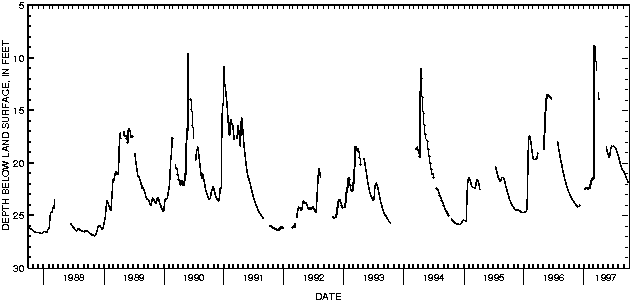

![]() U.S. Department of the Interior |
U.S. Geological Survey
U.S. Department of the Interior |
U.S. Geological Survey
URL: http://pubsdata.usgs.gov/pubs/wdr/1997/oh-97-2/sw97/pike.html
Page Contact Information: GS Pubs Web Contact
Page Last Modified: Friday, 09-Nov-2018 12:19:47 EST
