Water Data Report 1997
				411401081025000. LOCAL NUMBER, PO-1


LOCATION.--Lat 41014'01", long 81002'50" Hydrologic Unit 05030103. Bauer Street in Windham.
   Owner: Cristopher Minter.
AQUIFER.--Sandstone of Pennsylvanian Age.
WELL CHARACTERISTICS.--Drilled unused artesian well, diameter 6 in., depth 55 ft, cased.
INSTRUMENTATION.--Type F continuous recorder.
DATUM.--Elevation of land-surface datum is 980 ft above sea level, from topographic map.
   Measuring point: Floor of instrument shelter 0.60 ft above land-surface datum.
REMARKS.--Station operated by Ohio Department of Natural Resources, Division of Water.
PERIOD OF RECORD.--May 1946 to current year.
EXTREMES FOR PERIOD OF RECORD.--Maximum daily low, 23.32 ft below land-surface datum, Mar. 13, 1992;
   minimum daily low, 14.59 ft below land-surface datum, June 24, 1947.


	DEPTH BELOW LAND SURFACE (WATER LEVEL) (FEET), WATER YEAR OCTOBER 1996 TO SEPTEMBER 1997
					DAILY MAXIMUM VALUES

 DAY       OCT      NOV      DEC      JAN      FEB      MAR      APR      MAY      JUN      JUL      AUG      SEP

   1     20.20    20.16    19.90    19.37    19.22    18.82    18.10    17.85    17.56    17.75    18.92    19.52
   2     20.20    20.20    19.85    19.27    19.22    18.78    18.10    17.85    17.46    17.76    18.84    19.52
   3     20.24    20.23    19.77    19.28    19.28    18.78    18.03    17.79    17.46    17.80    18.83    19.55
   4     20.25    20.25    19.79    19.28    19.28    18.73    18.01    17.82    17.45    17.88    18.83    19.57
   5     20.25    20.24    19.77    19.25    19.16    18.72    18.01    17.82    17.42    17.93    18.89    19.57

   6     20.24    20.23    19.66    19.31    19.17    18.60    17.94    17.82    17.41    17.97    18.92    19.58
   7     20.20    20.23    19.65    19.33    19.17    18.68    18.01    17.85    17.41    18.02    18.95    19.58
   8     20.18    20.16    19.65    19.34    19.16    18.64    18.02    17.84    17.41    18.04    19.00    19.62
   9     20.15    20.11    19.71    19.32    19.16    18.65    18.05    17.73    17.42    18.05    19.00    19.64
  10     20.21    20.09    19.71    19.17    19.15    18.50    18.05    17.76    17.42    18.13    19.01    19.64

  11     20.30    20.10    19.63    19.28    19.14    18.49    18.04    17.76    17.40    18.15    19.05    19.65
  12     20.30    20.13    19.55    19.34    19.13    18.51    17.98    17.73    17.38    18.16    19.06    19.68
  13     20.29    20.15    19.57    19.36    19.19    18.51    17.89    17.70    17.33    18.16    19.06    19.72
  14     20.28    20.15    19.57    19.36    19.14    18.49    17.95    17.71    17.36    18.17    19.09    19.75
  15     20.29    20.13    19.57    19.35    19.12    18.38    17.95    17.71    17.40    18.19    19.17    19.77

  16     20.29    20.15    19.53    19.23    19.15    18.39    17.94    17.80    17.40    18.25    19.17    19.77
  17     20.26    20.13    19.49    19.28    19.17    18.39    17.86    17.80    17.35    18.27    19.16    19.78
  18     20.27    20.11    19.42    19.27    19.16    18.31    17.83    17.77    17.35    18.27    19.19    19.79
  19     20.23    20.07    19.43    19.31    19.08    18.31    17.79    17.75    17.42    18.32    19.20    19.83
  20     20.21    20.00    19.46    19.28    19.08    18.25    17.79    17.77    17.42    18.38    19.20    19.86

  21     20.18    19.97    19.47    19.37    19.05    18.20    17.79    17.80    17.42    18.39    19.20    19.86
  22     20.19    19.98    19.45    19.36    19.03    18.18    17.77    17.80    17.50    18.41    19.23    19.88
  23     20.19    20.00    19.44    19.33    19.07    18.20    17.77    17.80    17.55    18.44    19.29    19.90
  24     20.14    20.00    19.39    19.35    19.07    18.26    17.80    17.79    17.55    18.46    19.30    19.90
  25     20.19    19.98    19.41    19.27    19.07    18.23    17.87    17.71    17.57    18.50    19.30    19.91

  26     20.20    19.98    19.41    19.35    18.97    18.10    17.88    17.67    17.60    18.50    19.32    19.92
  27     20.20    19.96    19.38    19.35    18.87    18.10    17.86    17.73    17.68    18.52    19.32    19.90
  28     20.20    19.93    19.34    19.26    18.89    18.07    17.75    17.74    17.69    18.55    19.36    19.95
  29     20.16    19.95    19.34    19.30      ---    18.04    17.77    17.72    17.72    18.68    19.45    19.96
  30     20.16    19.92    19.35    19.28      ---    18.05    17.75    17.68    17.76    18.84    19.46    20.01
  31     20.17      ---    19.38    19.15      ---    18.08      ---    17.65      ---    18.92    19.48      ---

 MAX     20.30    20.25    19.90    19.37    19.28    18.82    18.10    17.85    17.76    18.92    19.48    20.01

 CAL YR 1996   LOW 21.17
 WTR YR 1997   LOW 20.30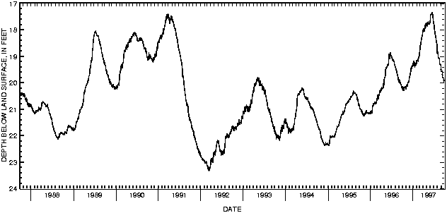

![]() U.S. Department of the Interior |
U.S. Geological Survey
U.S. Department of the Interior |
U.S. Geological Survey
URL: http://pubsdata.usgs.gov/pubs/wdr/1997/oh-97-2/sw97/portage.html
Page Contact Information: GS Pubs Web Contact
Page Last Modified: Friday, 09-Nov-2018 12:19:47 EST
