Water Data Report 1997
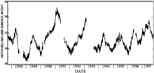
404625082305100. LOCAL NUMBER, R-4 LOCATION.--Lat 40046'25", long 82030'51", Hydrologic Unit 05040002, at Ohio Brass Plant in Mansfield. Owner: Ohio Brass Company AQUIFER.--Sand and gravel of Pleistocene Age. WELL CHARACTERISTICS.--Drilled unused artesian well, diameter 14 in., depth 127 ft, cased. INSTRUMENTATION.--Digital recorder--60-minute punch. DATUM.--Elevation of land-surface datum is 1150 ft above sea level, from topographic map. Measuring point: Top of platform 5.00 ft above land-surface datum. REMARKS.--Station operated by Ohio Department of Natural Resources, Division of Water. PERIOD OF RECORD.--May 1942 to current year. EXTREMES FOR PERIOD OF RECORD.--Maximum daily low, 60.10 ft below land-surface datum, Oct. 12, 13, 19, 20, 1962; minimum daily low, 3.61 ft below land-surface datum, June 15-20, 1997. DEPTH BELOW LAND SURFACE (WATER LEVEL) (FEET), WATER YEAR OCTOBER 1996 TO SEPTEMBER 1997 DAILY MAXIMUM VALUES DAY OCT NOV DEC JAN FEB MAR APR MAY JUN JUL AUG SEP 1 4.38 4.32 4.32 3.95 4.08 4.03 3.78 3.92 3.82 3.76 3.98 4.02 2 4.38 4.32 4.29 3.95 4.07 4.01 3.79 3.92 3.81 3.77 3.99 4.03 3 4.37 4.32 4.28 3.94 4.07 4.01 3.80 3.92 3.78 3.78 4.00 4.03 4 4.37 4.32 4.26 3.93 4.07 4.00 3.81 3.92 3.74 3.78 4.01 4.05 5 4.37 4.33 4.26 3.93 4.07 3.99 3.81 3.92 3.71 3.79 4.01 4.06 6 4.37 4.33 4.24 3.90 4.06 3.96 3.81 3.92 3.69 3.80 4.01 4.09 7 4.37 4.33 4.22 3.90 4.06 3.96 3.81 3.92 3.67 3.82 4.01 4.10 8 4.36 4.33 4.21 3.92 4.06 3.95 3.82 3.92 3.65 3.84 4.02 4.10 9 4.36 4.33 4.19 3.93 4.06 3.95 3.83 3.92 3.64 3.84 4.03 4.11 10 4.35 4.32 4.19 3.93 4.06 3.93 3.85 3.92 3.63 3.85 4.04 4.11 11 4.34 4.31 4.18 3.94 4.06 3.91 3.87 3.92 3.63 3.90 4.05 4.06 12 4.34 4.32 4.15 3.96 4.06 3.89 3.87 3.92 3.62 3.91 4.06 4.03 13 4.35 4.34 4.13 3.98 4.06 3.89 3.87 3.91 3.62 3.92 4.08 4.05 14 4.35 4.35 4.12 4.00 4.06 3.86 3.87 3.91 3.62 3.92 4.08 4.06 15 4.35 4.36 4.12 4.00 4.06 3.83 3.87 3.90 3.61 3.94 4.08 4.08 16 4.35 4.37 4.12 4.01 4.06 3.83 3.90 3.89 3.61 3.95 4.08 4.08 17 4.35 4.38 4.09 4.02 4.06 3.83 3.90 3.88 3.61 3.95 4.08 4.09 18 4.35 4.38 4.07 4.02 4.07 3.83 3.90 3.88 3.61 3.97 4.08 4.10 19 4.34 4.38 4.06 4.03 4.07 3.82 3.90 3.88 3.61 3.97 4.03 4.11 20 4.34 4.38 4.06 4.05 4.07 3.81 3.90 3.88 3.61 3.98 4.00 4.11 21 4.34 4.38 4.06 4.06 4.07 3.79 3.90 3.87 3.62 4.01 4.00 4.12 22 4.34 4.38 4.04 4.07 4.05 3.78 3.90 3.87 3.64 4.01 4.00 4.12 23 4.33 4.38 4.04 4.07 4.05 3.78 3.90 3.87 3.65 4.01 4.00 4.14 24 4.33 4.37 4.02 4.07 4.05 3.77 3.90 3.87 3.68 4.01 4.00 4.15 25 4.32 4.37 4.00 4.07 4.06 3.78 3.90 3.87 3.71 4.02 4.00 4.15 26 4.32 4.34 4.00 4.07 4.06 3.78 3.90 3.87 3.71 4.03 4.00 4.16 27 4.33 4.34 4.00 4.08 4.03 3.78 3.91 3.87 3.71 4.03 4.00 4.16 28 4.33 4.34 3.99 4.08 4.03 3.78 3.92 3.84 3.72 3.98 4.01 4.16 29 4.33 4.34 3.97 4.08 --- 3.78 3.92 3.83 3.74 3.97 4.01 4.16 30 4.33 4.34 3.96 4.08 --- 3.78 3.92 3.83 3.75 3.97 4.01 4.16 31 4.32 --- 3.95 4.08 --- 3.78 --- 3.83 --- 3.98 4.01 --- MAX 4.38 4.38 4.32 4.08 4.08 4.03 3.92 3.92 3.82 4.03 4.08 4.16 CAL YR 1996 LOW 4.92 WTR YR 1997 LOW 4.38405753082360800. LOCAL NUMBER, R-3 LOCATION.--Lat 40057'53", long 82036'08", Hydrologic Unit 05040002, Voisard plant in Shiloh. Owner: Voisard Corp. AQUIFER.--Sand and gravel of Pleistocene Age. WELL CHARACTERISTICS.--Drilled unused artesian well, diameter 8 in., depth 150 ft, cased. INSTRUMENTATION.--Digital recorder--60-minute punch. DATUM.--Elevation of land-surface datum is 1080 ft above sea level, from topographic map. Measuring point: Floor of instrument shelter 3.17 ft above land-surface datum. REMARKS.--Station operated by Ohio Department of Natural Resources, Division of Water. Published in WDR OH Vol. 2 prior to 1995 water year. PERIOD OF RECORD.--April 1946 to current year. EXTREMES FOR PERIOD OF RECORD.--Maximum daily low, 35.90 ft below land-surface datum, Feb. 12, 1981; minimum daily low, 23.68 ft below land-surface datum, June 15, 23, 1947. DEPTH BELOW LAND SURFACE (WATER LEVEL) (FEET), WATER YEAR OCTOBER 1996 TO SEPTEMBER 1997 DAILY MAXIMUM VALUES DAY OCT NOV DEC JAN FEB MAR APR MAY JUN JUL AUG SEP 1 33.34 32.92 32.60 32.08 31.85 31.89 31.34 31.22 30.84 30.76 31.92 32.44 2 33.28 33.08 32.79 31.65 31.98 31.93 31.34 31.23 30.82 30.72 31.71 32.46 3 33.41 33.21 32.82 31.60 32.18 31.88 31.15 31.16 30.87 30.78 31.66 32.54 4 33.48 33.22 33.03 31.61 31.80 31.81 31.09 31.33 30.87 30.90 31.67 32.53 5 33.39 33.09 32.91 31.57 32.04 31.81 31.00 31.33 30.78 31.02 31.82 32.49 6 33.21 33.07 32.54 31.86 32.07 31.96 30.87 31.45 30.73 31.06 31.91 32.29 7 33.02 32.88 32.48 32.04 32.07 32.03 31.19 31.51 30.73 31.20 31.96 32.33 8 32.84 32.71 32.48 32.04 32.18 32.05 31.32 31.36 30.73 31.20 31.92 32.31 9 32.89 32.81 32.84 31.71 32.20 32.02 31.36 31.22 30.80 31.23 31.83 32.29 10 33.20 33.00 32.73 31.39 32.11 31.64 31.37 31.31 30.82 31.31 31.85 32.22 11 33.31 33.31 32.59 31.84 32.03 31.72 31.26 31.30 30.70 31.30 31.96 32.38 12 33.18 33.44 32.69 32.18 32.32 31.83 30.91 31.04 30.51 31.22 31.96 32.50 13 33.09 33.43 32.89 32.25 32.34 31.82 31.17 31.04 30.39 31.12 31.82 32.52 14 33.15 33.48 32.92 32.23 31.87 31.37 31.34 31.04 30.59 31.13 31.81 32.52 15 33.14 33.48 32.88 32.01 32.22 31.70 31.33 31.18 30.59 31.30 31.79 32.52 16 32.93 33.29 32.56 31.81 32.35 31.80 31.09 31.28 30.42 31.34 31.85 32.52 17 32.94 33.13 32.37 31.89 32.38 31.53 31.03 31.17 30.48 31.32 31.89 32.47 18 32.87 32.98 32.41 31.97 32.09 31.49 31.01 31.16 30.51 31.28 32.05 32.57 19 32.90 32.80 32.38 31.93 32.37 31.46 30.93 31.26 30.56 31.49 32.06 32.50 20 32.92 32.84 32.59 32.13 32.39 31.09 30.96 31.39 30.56 31.48 31.92 32.70 21 32.98 32.95 32.56 32.20 31.96 30.99 30.92 31.49 30.56 31.55 31.89 32.79 22 32.98 33.12 32.36 31.81 32.31 31.13 30.91 31.54 30.75 31.55 32.07 32.71 23 32.85 33.02 32.23 32.17 32.44 31.40 30.90 31.53 30.83 31.53 32.21 32.68 24 33.06 32.91 32.34 32.07 32.46 31.46 31.15 31.36 30.84 31.64 32.22 32.69 25 33.20 32.93 32.39 32.11 32.38 31.21 31.39 31.13 30.79 31.64 32.20 32.40 26 33.28 33.29 32.43 32.25 31.98 31.13 31.44 31.35 30.84 31.58 32.20 32.57 27 33.23 33.40 32.23 32.11 32.03 31.01 31.34 31.45 30.91 31.57 32.12 32.55 28 33.06 33.26 31.95 32.29 32.10 30.91 31.04 31.44 30.88 31.73 32.15 32.38 29 33.00 33.07 32.16 32.32 --- 30.96 31.07 31.29 30.88 31.91 32.21 32.13 30 32.94 32.84 32.20 32.08 --- 30.96 31.02 31.15 30.81 31.96 32.18 32.48 31 32.98 --- 32.22 31.68 --- 31.21 --- 31.06 --- 31.94 32.32 --- MAX 33.48 33.48 33.03 32.32 32.46 32.05 31.44 31.54 30.91 31.96 32.32 32.79 CAL YR 1996 LOW 34.79 WTR YR 1997 LOW 33.48

![]() U.S. Department of the Interior |
U.S. Geological Survey
U.S. Department of the Interior |
U.S. Geological Survey
URL: http://pubsdata.usgs.gov/pubs/wdr/1997/oh-97-2/sw97/richland.html
Page Contact Information: GS Pubs Web Contact
Page Last Modified: Friday, 09-Nov-2018 12:19:45 EST
