Water Data Report 1997
				391341083172200. LOCAL NUMBER, RO-7


LOCATION.--Lat 39013'41", long 83017'22", Hydrologic Unit 05060003, Highland County well field, 1 mi west
   of Bainbridge.
   Owner: Highland County Water Company.
AQUIFER.--Sand and gravel of Quaternary Age.
WELL CHARACTERISTICS.--Drilled test water table well, diameter 6 in., depth 67 ft, cased.
INSTRUMENTATION.--Digital recorder--60-minute punch.
DATUM.--Elevation of land-surface datum is 740 ft above sea level, from topographic map.
   Measuring point: Floor of instrument shelter 3.00 ft above land-surface datum.
REMARKS.--Station operated by Ohio Department of Natural Resources, Division of Water.
PERIOD OF RECORD.--February 1971 to current year.
EXTREMES FOR PERIOD OF RECORD.--Maximum daily low, 45.88 ft below land-surface datum, Dec. 31, 1989;
   minimum daily low, 20.93 ft below land-surface datum, Feb. 28, 1971.


	DEPTH BELOW LAND SURFACE (WATER LEVEL) (FEET), WATER YEAR OCTOBER 1996 TO SEPTEMBER 1997
					DAILY MAXIMUM VALUES

 DAY       OCT      NOV      DEC      JAN      FEB      MAR      APR      MAY      JUN      JUL      AUG      SEP

   1     38.89    36.65    36.41    34.88    36.23    36.58    30.98    35.19    36.54    35.21    37.14    36.06
   2     38.85    36.87    36.81    35.29    35.98    36.34    31.01    35.21    36.45    34.88    37.09    36.39
   3     38.69    36.89    36.64    35.31    35.81    34.89    31.51    35.37    36.36    34.80    37.06    36.69
   4     37.82    36.06    36.32    35.22    35.59    33.68    31.89    35.09    36.33    34.55    37.08    36.34
   5     37.76    36.21    35.10    35.51    35.61    33.09    31.63    34.85    35.87    34.59    37.17    35.83

   6     36.75    35.38    35.23    35.36    35.60    32.25    31.93    35.12    35.95    34.11    37.45    35.15
   7     37.09    35.98    35.26    35.66    35.39    32.25    31.64    35.25    35.57    34.22    37.47    35.42
   8     36.85    36.28    34.77    35.22    35.27    31.87    31.86    35.58    35.38    34.24    37.84    35.37
   9     36.94    36.55    34.98    35.59    35.19    31.60    31.22    35.90    34.56    34.61    37.50    35.68
  10     36.24    36.71    34.99    35.26    35.14    30.85    31.18    35.97    34.67    34.67    37.92    35.00

  11     36.49    36.87    34.17    35.18    35.09    30.46    31.92    35.45    34.27    34.68    37.46    35.28
  12     35.80    37.01    34.60    34.93    35.08    30.17    32.38    35.88    34.27    34.63    37.70    35.85
  13     36.08    37.04    34.20    35.19    34.90    29.18    32.88    36.21    33.64    34.79    37.28    35.59
  14     35.80    35.96    34.62    35.25    35.10    29.47    33.10    36.46    33.83    34.91    37.30    36.05
  15     36.20    36.54    34.03    35.42    35.03    29.15    32.45    36.04    33.86    35.05    36.88    35.98

  16     35.96    36.97    34.50    35.67    35.28    29.09    32.97    35.96    34.02    35.11    36.45    36.36
  17     35.79    37.25    34.39    35.86    35.25    28.77    32.67    35.80    34.12    35.40    36.61    36.50
  18     36.25    37.41    34.52    36.01    35.49    28.86    33.16    35.91    33.84    35.68    36.03    36.75
  19     36.40    37.26    33.86    36.14    35.54    28.48    32.84    36.00    34.06    36.03    36.29    36.98
  20     35.49    37.42    33.90    36.28    35.65    29.05    33.47    36.23    34.17    36.23    35.43    37.16

  21     36.07    37.25    33.90    36.41    35.69    29.21    33.13    36.28    34.17    36.52    35.51    37.34
  22     36.21    37.31    33.26    36.46    35.78    28.77    33.76    35.46    33.90    36.79    35.31    37.46
  23     36.21    36.38    33.42    36.76    35.66    29.39    33.49    35.82    34.07    36.85    34.98    37.67
  24     35.89    36.77    33.63    36.76    35.82    29.49    33.02    36.01    34.20    37.04    35.17    37.79
  25     35.06    36.79    33.77    36.91    35.92    29.77    33.64    36.17    34.25    37.06    34.98    37.93

  26     35.45    35.49    33.87    36.61    35.99    29.80    34.04    36.27    34.41    37.29    35.22    38.04
  27     34.79    36.01    33.98    36.71    36.07    29.57    34.11    36.36    34.77    37.22    34.69    38.10
  28     35.24    36.05    33.16    36.35    36.14    29.59    34.01    36.40    34.79    37.37    35.17    38.21
  29     35.39    35.48    33.66    36.24      ---    30.00    34.38    36.45    35.09    37.25    35.23    38.28
  30     36.00    35.30    33.94    35.87      ---    30.00    34.76    36.49    34.96    37.37    35.36    38.43
  31     36.40      ---    34.20    35.81      ---    30.26      ---    36.07      ---    37.09    35.63      ---

 MAX     38.89    37.42    36.81    36.91    36.23    36.58    34.76    36.49    36.54    37.37    37.92    38.43

 CAL YR 1996   LOW 39.42
 WTR YR 1997   LOW 38.89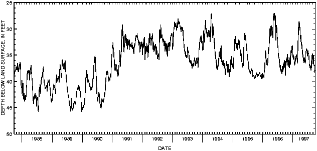

![]() U.S. Department of the Interior |
U.S. Geological Survey
U.S. Department of the Interior |
U.S. Geological Survey
URL: http://pubsdata.usgs.gov/pubs/wdr/1997/oh-97-2/sw97/ross.html
Page Contact Information: GS Pubs Web Contact
Page Last Modified: Friday, 09-Nov-2018 12:19:45 EST
