 |
 |
The Water Resources Division of the U.S. Geological Survey, in cooperation with many other agencies, obtains a large amount of data pertaining to the water resources of North Dakota each water year. These data, accumulated during many water years, constitute a valuable data base for developing an improved understanding of the water resources of the State. To make these data readily available to interested parties outside the U.S. Geological Survey, the data will be published annually in this report series entitled "Water Resources Data - North Dakota."
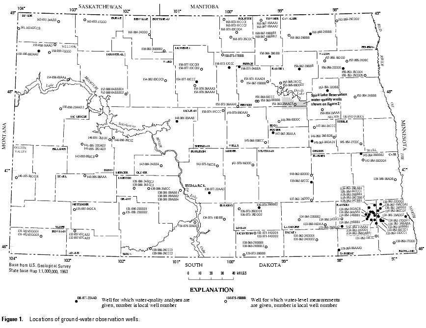
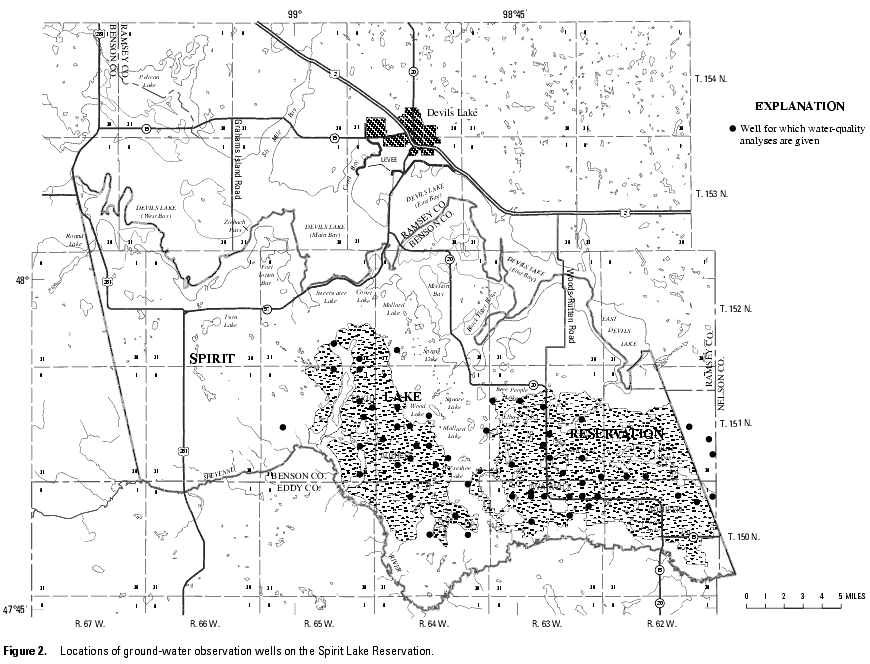
This report includes records on ground water in North Dakota. Specifically, it contains water-level records for 136 wells and water-quality records for 97 wells. Locations of the ground-water wells are shown in figures 1 and 2 . This report also includes ground-water levels for wells that were monitored as part of a cooperative study with the U.S. Fish and Wildlife Service during water year 2004. Additional ground-water information for North Dakota is contained in the files, data bases, and other published reports of the U.S. Geological Survey.
This series of annual reports for North Dakota began with the 1961 water year report that contained only data relating to the quantities of surface water. For the 1964 water year, a similar report was introduced that contained only data relating to water quality. For the 1975-95 water years, the report format was changed to present, in one volume, data on quantities of surface water, quality of surface and ground water, and ground-water levels. Beginning with the 1996 water year, ground-water levels and ground-water quality data will be published in a separate volume for North Dakota.
Prior to introduction of this series and for several water years concurrent with it, water resources data for North Dakota were published in U.S. Geological Survey Water-Supply Papers. Data on stream discharge and stage and on lake or reservoir contents and stage, through September 1960, were published annually under the title "Surface-Water Supply of the United States, Parts 5 and 6." For the 1961-70 water years, the data were published in two 5-year reports. Data on chemical quality, temperature, and suspended sediment for the 1941-70 water years were published annually under the title "Quality of Surface Waters of the United States," and ground-water levels for the 1935-74 water years were published under the title "Ground-Water Levels in the United States." The above mentioned Water-Supply Papers are in libraries of the principal cities of the United States and may be purchased from U.S. Geological Survey, Branch of Information Services, Box 25286, Denver, CO 80225-0286.
Publications similar to this report are published annually by the U.S. Geological Survey for all States. These official U.S. Geological Survey reports have an identification number consisting of the two-letter State abbreviation, the last two digits of the water year, and the volume number. For example, this volume is identified as "U.S. Geological Survey Water-Data Report ND-04-2." For archiving and general distribution, the reports for the 1971-74 water years also are identified as water-data reports. These water-data reports are for sale in paper copy or may be purchased on microfiche from the National Technical Information Service, U.S. Department of Commerce, Springfield, VA 22161.
Additional information, including the current prices, for ordering specific reports may be obtained from the District Chief at the address given on the back of the title page or by telephoning (701) 250-7406.
Organizations that assisted in the collection of ground-water data in this report through joint funding agreements with the U.S. Geological Survey are:
The geography and geology of North Dakota are sufficiently complex that a summary of ground-water conditions over the entire State is difficult. Descriptions of conditions in specific aquifers apply only to that geographic area and cannot be considered to be the same for other geographic areas.
Ground-water levels fluctuate in response to a variety of stresses and changes in stress. Short- and long-term climatic conditions can lead to changes in natural recharge and discharge. Superimposed on the natural fluctuations in water levels are changes caused by increasing or decreasing ground-water withdrawals and, in some areas, changes caused by recharge from surface irrigation.
The ground-water records published in this report are for the 2004 water year that began October 1, 2003, and ended September 30, 2004. A calendar of the water year is provided on the inside of the front cover. The records contain ground-water level and ground-water quality data. The following sections of the introductory text are presented to provide users with a more detailed explanation of how the hydrologic data published in this report were collected, analyzed, computed, and arranged for presentation.
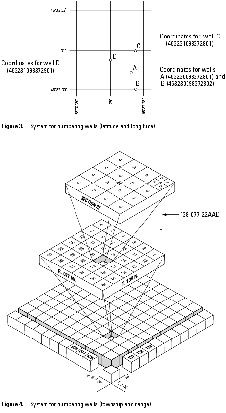
Each well is identified by means of (1) a 15-digit number that is based on latitude and longitude and (2) a local number that is produced for local needs.
The USGS well and miscellaneous site-numbering system is based on the grid system of latitude and longitude. The system provides the geographic location of the well or miscellaneous site and a unique number for each site. The number consists of 15 digits. The first 6 digits denote the degrees, minutes, and seconds of latitude, and the next 7 digits denote degrees, minutes, and seconds of longitude; the last 2 digits are a sequential number for wells within a 1-second grid. In the event that the latitude-longitude coordinates for a well and miscellaneous site are the same, a sequential number such as "01," "02," and so forth, would be assigned as one would for wells (see fig. 3). The 8-digit, downstream order station numbers are not assigned to wells and miscellaneous sites where only random water-quality samples or discharge measurements are taken. During water year 2003, the true latitude and longitude listed in the LOCATION paragraph was changed slightly at some locations. The change was made based on new information and does not signify a change in the gage location unless otherwise noted.
In addition to the well number that is based on the latitude and longitude for each well, another well number may be provided which in many states is based on the Public Land Survey System, a set of rectangular surveys that is used to identify land parcels. This well number is familiar to the water users of North Dakota and shows the location of the well by quadrant, township, range section, and position within the section (see fig. 4). The capital letter at the beginning of the location number indicates the quadrant in which the well is located. Four quadrants are formed by the intersection of the base line and the principal meridian-A indicates the northeast quadrant, B the northwest, C the southwest, and D the southeast. The first numeral indicates the township, the second the range, and the third the section in which the well is located. Lowercase letters following the section number locate the well within the section. The first letter denotes the quarter section, the second the quarter-quarter section, and the third the quarter-quarter-quarter section. The letters are assigned within the section in a counter-clockwise direction beginning with (a) in the northeast quarter of the section. Letters are assigned within each quarter section and quarter-quarter section in the same manner. Where two or more wells are located within the smallest subdivision, consecutive numbers beginning with 1 are added to the letters in the order in which the wells are inventoried. For example, site 138-077-22AAD is in the SE1/4NE1/4NE1/4 sec.22, T.138 N., R.077 W. Consecutive terminal numbers are added if more than one site is recorded within a 10-acre tract.
Measurements are made in many types of wells, under varying conditions of access and at different temperatures; hence, neither the method of measurement nor the equipment can be standardized. At each observation well, however, the equipment and techniques used are those that will ensure that measurements at each well are consistent.
Most methods for collecting and analyzing water samples are described in the Techniques of Water-Resources Investigations of the United States Geological Survey (TWRIs). In addition, TWRI Book 1, Chapter D2, describes guidelines for the collection and field analysis of ground-water samples for selected unstable constituents. Procedures for on-site measurements and for collecting, treating, and shipping samples are given in TWRIs Book 1, Chapter D2; Book 3, Chapters A1, A3, and A4; and Book 9, Chapters A1 through A9. The TWRI publications may be accessed from http://water.usgs.gov/pubs/twri/. The values in this report represent water-quality conditions at the time of sampling, as much as possible, and that are consistent with available sampling techniques and methods of analysis. These methods are consistent with ASTM standards and generally follow ISO standards. Trained personnel collected all samples. The wells sampled were pumped long enough to ensure that the water collected came directly from the aquifer and had not stood for a long time in the well casing where it would have been exposed to the atmosphere and to the material, possibly metal, comprising the casings.
Water-level measurements in this report are given in feet with reference to land-surface datum (lsd). Land-surface datum is a datum plane that is approximately at land surface at each well. If known, the elevation of the land-surface datum above sea level is given in the well description. The height of the measuring point (MP) above or below land-surface datum is given in each well description. Water levels in wells equipped with recording gages are reported for every fifth day and the end of each month (EOM).
Water levels are reported to as many significant figures as can be justified by the local conditions. For example, in a measurement of a depth of water of several hundred feet, the error in determining the absolute value of the total depth to water may be a few tenths of a foot, whereas the error in determining the net change of water level between successive measurements may be only a hundredth or a few hundredths of a foot. For lesser depths to water the accuracy is greater. Accordingly, most measurements are reported to a hundredth of a foot, but some are given only to a tenth of a foot or a larger unit.
Water-level data are presented in alphabetical order by county. The primary identification number for a given well is the 15-digit site identification number that appears in the upper left corner of the table. The secondary identification number is the local or county well number. Well locations are shown in figures 1 and 2; each well is identified on the map by its local well or county well number.
Each well record consists of three parts: the well description, the data table of water levels observed during the water year, and, for most wells, a hydrograph following the data table. Well descriptions are presented in the headings preceding the tabular data.
The following comments clarify information presented in these various headings.
LOCATION.-This paragraph follows the well-identification number and reports the hydrologic-unit number and a geographic point of reference. Latitudes and longitudes used in this report are reported as North American Datum of 1927 unless otherwise specified.
WELL CHARACTERISTICS.-This entry describes the well in terms of depth, casing diameter and depth or screened interval, method of construction, use, and changes since construction.
INSTRUMENTATION.-This paragraph provides information on both the frequency of measurement and the collection method used, allowing the user to better evaluate the reported water-level extremes by knowing whether they are based on continuous, monthly, or some other frequency of measurement.
DATUM.-This entry describes both the measuring point and the land-surface elevation at the well. The altitude of the land-surface datum is described in feet above the altitude datum; it is reported with a precision depending on the method of determination. The measuring point is described physically (such as top of casing, top of instrument shelf, and so forth), and in relation to land surface (such as 1.3 ft above land-surface datum). The elevation of the land-surface datum is described in feet above National Geodetic Vertical Datum of 1929 (NGVD 29); it is reported with a precision depending on the method of determination.
REMARKS.-This entry describes factors that may influence the water level in a well or the measurement of the water level, when various methods of measurement were begun, and the network (climatic, terrane, local, or areal effects) or the special project to which the well belongs.
PERIOD OF RECORD.-This entry indicates the time period for which records are published for the well, the month and year at the start of publication of water-level records by the USGS, and the words "to current year" if the records are to be continued into the following year. Time periods for which water-level records are available, but are not published by the USGS, may be noted.
EXTREMES FOR PERIOD OF RECORD.-This entry contains the highest and lowest instantaneously recorded or measured water levels of the period of published record, with respect to land-surface datum or sea level, and the dates of occurrence.
A table of water levels follows the well description for each well. Water-level measurements in this report are given in feet with reference to either sea level or land-surface datum (lsd). Missing records are indicated by dashes in place of the water-level value.
For wells not equipped with recorders, water-level measurements were obtained periodically by steel or electric tape. Tables of periodic water-level measurements in these wells show the date of measurement and the measured water-level value.
Hydrographs are a graphic display of water-level fluctuations over a period of time. In this report, current water year and, when appropriate, period-of-record hydrographs are shown. Hydrographs that display periodic water-level measurements show points that may be connected with a dashed line from one measurement to the next. Hydrographs that display recorder data show a solid line representing the mean water level recorded for each day. Missing data are indicated by a blank space or break in a hydrograph. Missing data may occur as a result of recorder malfunctions, battery failures, or mechanical problems related to the response of the recorder's float mechanism to water-level fluctuations in a well.
The ground-water-quality data in this report were obtained as a part of special studies in specific areas. Consequently, a number of chemical analyses are presented for some wells within a county but not for others. As a result, the records for this year, by themselves, do not provide a balanced view of ground-water quality Statewide.
Most of the methods used for collecting and analyzing water samples are described in the TWRIs, which may be accessed from http://water.usgs.gov/pubs/twri/. Procedures for on-site measurements and for collecting, treating, and shipping samples are given in TWRI, Book 1, Chapter D2; Book 5, Chapters A1, A3, and A4; and Book 9, Chapters A1-A6. Also, detailed information on collecting, treating, and shipping samples may be obtained from the USGS District office (see address shown on back of title page in this report).
Analysis for sulfide and measurement of alkalinity, pH, water temperature, specific conductance, and dissolved oxygen are performed on site. All other sample analyses are performed at the USGS laboratory in Lakewood, Colorado, unless otherwise noted. Methods used by the USGS laboratory are given in TWRI, Book 1, Chapter D2 and Book 5, Chapters A1, A3, and A4, which may be accessed from http://water.usgs.gov/pubs/twri/.
The following remark codes may appear with the water-quality data in this section:
quantified.Blank samples are collected and analyzed to ensure that environmental samples have not been contaminated in the overall data-collection process. The blank solution used to develop specific types of blank samples is a solution that is free of the analytes of interest. Any measured value signal in a blank sample for an analyte (a specific component measured in a chemical analysis) that was absent in the blank solution is believed to be due to contamination. Many types of blank samples are possible; each is designed to segregate a different part of the overall data-collection process. The types of blank samples collected in this district are:
Field blank-A blank solution that is subjected to all aspects of sample collection, field processing preservation, transportation, and laboratory handling as an environmental sample.
Trip blank-A blank solution that is put in the same type of bottle used for an environmental sample and kept with the set of sample bottles before and after sample collection.
Equipment blank-A blank solution that is processed through all equipment used for collecting and processing an environmental sample (similar to a field blank but normally done in the more controlled conditions of the office).
Sampler blank-A blank solution that is poured or pumped through the same field sampler used for collecting an environmental sample.
Filter blank-A blank solution that is filtered in the same manner and through the same filter apparatus used for an environmental sample.
Splitter blank-A blank solution that is mixed and separated using a field splitter in the same manner and through the same apparatus used for an environmental sample.
Preservation blank-A blank solution that is treated with the sampler preservatives used for an environmental sample.
Reference material is a solution or material prepared by a laboratory. The reference material composition is certified for one or more properties so that it can be used to assess a measurement method. Samples of reference material are submitted for analysis to ensure that an analytical method is accurate for the known properties of the reference material. Generally, the selected reference material properties are similar to the environmental sample properties.
Replicate samples are a set of environmental samples collected in a manner such that the samples are thought to be essentially identical in composition. Replicate is the general case for which a duplicate is the special case consisting of two samples. Replicate samples are collected and analyzed to establish the amount of variability in the data contributed by some part of the collection and analytical process. Many types of replicate samples are possible, each of which may yield slightly different results in a dynamic hydrologic setting, such as a flowing stream. The types of replicate samples collected in this district are:
Concurrent samples-A type of replicate sample in which the samples are collected simultaneously with two or more samplers or by using one sampler and alternating the collection of samples into two or more compositing containers.
Sequential samples-A type of replicate sample in which the samples are collected one after the other, typically over a short time.
Split sample-A type of replicate sample in which a sample is split into subsamples, each subsample contemporaneous in time and space.
Spike samples are samples to which known quantities of a solution with one or more well-established analyte concentrations have been added. These samples are analyzed to determine the extent of matrix interference or degradation on the analyte concentration during sample processing and analysis.
The USGS provides near real-time stage and discharge data for many of the gaging stations equipped with the necessary telemetry and historic daily-mean and peak-flow discharge data for most current or discontinued gaging stations through the World Wide Web (WWW). These data may be accessed from http://water.usgs.gov.
Terms related to water-quality, and other hydrologic data, as used in this report, are defined below. See also table for converting English units to International System (SI) Units on the inside of the back cover.
Aquifer is a geologic formation, group of formations, or part of a formation that contains sufficient saturated permeable material to yield significant quantities of water to wells and springs.
Dissolved refers to that material in a representative water sample which passes through a 0.45 micrometer membrane filter. This is a convenient operational definition used by Federal agencies that collect water data. Determination of "dissolved" constituents are made on subsamples of the filtrate.
Dissolved-solids concentration of water is determined either analytically by the "residue-on-evaporation" method, or mathematically by totaling the concentrations of individual constituents reported in a comprehensive chemical analysis. During the analytical determination of dissolved solids, the bicarbonate (generally a major dissolved component of water) is converted to carbonate. Therefore, in the mathematical calculation of dissolved-solids concentration, the bicarbonate value, in milligrams per liter, is multiplied by 0.493 to reflect the change.
Hardness of water is a physical-chemical characteristic that is commonly recognized by the increased quantity of soap required to produce lather. It is computed as the sum of equivalents of polyvalent cations and is expressed as the equivalent concentration of calcium carbonate (CaCO3).
Land-surface datum is a datum plane that is approximately at land surface at each ground-water observation well.
Micrograms per liter (UG/L, mg/L) is a unit expressing the concentration of chemical constituents in solution as mass (micrograms) of solute per unit volume (liter) of water. One thousand micrograms per liter is equivalent to one milligram per liter.
Microsiemens per centimeter at 25 degrees Celsius (US/CM, mS/cm) is a unit for reporting specific electrical conductance.
Milligrams per liter (MG/L, mg/L) is a unit for expressing the concentration of chemical constituents in solution. Milligrams per liter represents the mass of solute per unit volume (liter) of water. Concentration of suspended sediment also is expressed in mg/L and is based on the mass of dry sediment per liter of water-sediment mixture.
National Geodetic Vertical Datum of 1929 (NGVD of 1929) is a geodetic datum derived from a general adjustment of the first order level nets of both the United States and Canada. It was formerly called "Sea Level Datum of 1929" or "mean sea level" in this series of reports. Although the datum was derived from the average sea level over a period of many years at 26 tide stations along the Atlantic, Gulf of Mexico, and Pacific Coasts, it does not necessarily represent local mean sea level at any particular place.
Open or screened interval is the length of unscreened opening or of well screen through which water enters a well, in feet below land surface.
Parameter Code is a 5-digit number used in the U.S. Geological Survey's data system, National Water Information System (NWIS), to uniquely identify a specific constituent. The codes used in NWIS are the same as those used in the U.S. Environmental Protection Agency's data system, STORET. The Environmental Protection Agency assigns and approves all requests for new codes.
pH indicates the degree of acidity or alkalinity of water and is expressed in pH units. The pH value of a solution is the negative logarithm of the concentration of hydrogen ions, in moles per liter. A pH of 7.0 indicates that the water is neither acid nor alkaline. pH readings progressively less than 7.0 denote increasing acidity and those progressively greater than 7.0 denote increasingly alkalinity. The pH of most natural surface waters ranges between 6 and 8.
Sea level refers to the National Geodetic Vertical Datum of 1929--a geodetic datum derived from a general adjustment of the first-order level nets of the United States and Canada, formerly called Sea Level Datum of 1929.
Sodium-adsorption-ratio (SAR) is the expression of relative activity of sodium ions in exchange reactions within soil and is an index of sodium or alkali hazard to the soil. Waters range in respect to sodium hazard from those which can be used for irrigation on almost all soils to those which are generally unsatisfactory for irrigation.
Solute is any substance that is dissolved in water.
Specific conductance is a measure of the ability of a water to conduct an electrical current. It is expressed in microsiemens per centimeter at 25 degrees Celsius. Specific conductance is related to the type and concentration of ions in solution and can be used for approximating the dissolved-solids content of the water. Commonly, the concentration of dissolved solids (in milligrams per liter) is about 65 percent of the specific conductance (in microsiemens). This relation is not constant from well to well, and it may vary in the same source with changes in the composition of the water.
Total is the total amount of a given constituent in a representative water-suspended sediment sample, regardless of the constituent's physical or chemical form. This term is used only when the analytical procedure assures measurement of at least 95 percent of the constituent present in both the dissolved and suspended phases of the sample. A knowledge of the expected form of the constituent in the sample, as well as the analytical methodology used, is required to judge when the results should be reported as "total." (Note that the word "total" does double duty here, indicating both that the sample consists of a water-suspended sediment mixture and that the analytical method determined all of the constituent in the sample.)
Water year in Geological Survey reports dealing with surface- ground-water supply is the 12-month period October 1 through September 30. The water year is designated by the calendar year in which it ends and which includes 9 of the 12 months. Thus, the year ending September 30, 2004, is called "water year 2004."
Water-table aquifer is an unconfined aquifer within which is found the water table.
Well is an excavation (pit, hole, tunnel), generally cylindrical in form and often walled in, drilled, dug, driven, bored, or jetted into the ground to such a depth as to penetrate water-yielding geologic material and allow the water to flow or to be pumped to the surface.
|
U.S. Department of the Interior || U.S. Geological Survey Maintainer: Webmaster Privacy || Disclaimer|| Accessibility || FOIA |

|