 |
|
|
||||
| Alaska Annual Data Report 2005 |
MAIN LINKS IN REPORT
Main Report Page OTHER SITES
Alaska Science Center OTHER REPORTS
Water Related Reports OTHER INFORMATION |
|
EXPLANATION OF THE RECORDSThe surface-water and ground-water records published in this report are for the 2005 water year that began October 1, 2004, and ended September 30, 2005. The records contain streamflow data, stage and content data for lakes and reservoirs, water-quality data for surface and ground water, and ground-water-level data. The locations of the stations and wells where the data were collected are shown in the corresponding maps. The following sections of the introductory text are presented to provide users with a more detailed explanation of how the hydrologic data published in this report were collected, analyzed, computed, and arranged for presentation. Station Identification Numbers
Each data station, whether stream site, lake, reservoir, spring, or well, in this report is assigned a unique identification number. This number is unique in that it applies specifically to a given station and to no other. The number usually is assigned when a station is first established and is retained for that station indefinitely. The systems used by the U.S. Geological Survey to assign identification numbers for surface-water stations and for ground-water well sites differ, but both are based on geographic location. The “downstream order” system is used for regular surface-water stations and the “latitude-longitude” system is used for wells, lakes, reservoirs, springs, and for surface-water stations where only miscellaneous measurements and/or water-quality samples are collected. [ Back to Main Page ] [ Back to Top ] Downstream Order System
Since October 1, 1950, hydrologic-station records in USGS reports have been listed in order of downstream direction along the main stream. All stations on a tributary entering upstream from a main-stream station are listed before that station. A station on a tributary entering between two main-stream stations is listed between those stations. A similar order is followed in listing stations on first rank, second rank, and other ranks of tributaries. The rank of any tributary on which a station is located with respect to the stream to which it is immediately tributary is indicated by an indention in that list of stations in the front of this report. Each indentation represents one rank. This downstream order and system of indentation indicates which stations are on tributaries between any two stations and the rank of the tributary on which each station is located. Stations located on islands in Alaska are in downstream order starting at the most westerly point on the island and moving around the island in a counter-clockwise direction (stations on Kodiak Island start at the most northerly point). As an added means of identification, each hydrologic station and partial-record station has been assigned a station number. These station numbers are in the same downstream order used in this report. In assigning a station number, no distinction is made between partial-record stations and other stations; therefore, the station number for a partial-record station indicates downstream-order position in a list composed of both types of stations. Water-quality stations located at or near regular stations or partial-record stations have the same number as the regular or partial-record station. Gaps are left in the series of numbers to allow for new stations that may be established; hence, the numbers are not consecutive. The complete eight-digit number for each station, such as 15303600, which appears just to the left of the station name, includes the two-digit Part number “15” plus the six-digit downstream order number “303600.” The Part number designates the State of Alaska. Occasionally, the downstream order number consists of eight digits. [ Back to Main Page ] [ Back to Top ] Latitude-Longitude System
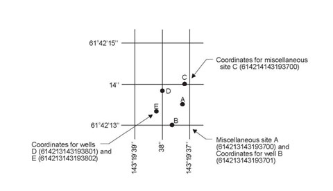
The identification numbers for miscellaneous surface-water sites, wells, springs, lakes, and reservoirs are assigned according to the grid system of latitude and longitude. The number consists of 15 digits. The first six digits denote the degrees, minutes, and seconds of latitude, the next seven digits denote degrees, minutes, and seconds of longitude, and the last two digits (assigned sequentially) identify the wells or other sites within a 1-second grid. This site-identification number, once assigned, is a pure number, and has no locational significance. In the rare instance where the initial determination of latitude and longitude are found to be in error, the station will retain its initial identification number; however, its true latitude and longitude will be listed in the LOCATION paragraph of the station description and also stored in the computerized data base files. See the accompanying diagram. [ Back to Main Page ] [ Back to Top ]
In addition to the well number that is based on the latitude and longitude for each well, another well number may be provided which in many States is based on the Public Land Survey System, a set of rectangular surveys that is used to identify land parcels. This well number is familiar to the water users of Alaska. The first two letters indicate the principal meridian and the quadrant formed by the intersection of the base line and the principal meridian. The first three digits indicate the township in which the well or spring is located, the next three digits the range, and the last two digits the section. The letters following the section number indicate the quarter section, the quarter-quarter section, and so forth to the fourth order subdivision. Each of these subdivisions is lettered counter-clockwise, from the northeast corner. Each site within the smallest order of subdivision is then given a sequential number. Finally, each well within a section is assigned a sequential map number indicated by the last three digits. Thus, SB00601115BCAD1 001 denotes the Seward meridian (S), the northwest quadrant (B), township 6 north, range 11 west, section 15; and the site is in the SE1/4 of NE1/4 of the SW1/4 of the NW1/4 (BCAD) of the section. It was the first site in the 2.5 acre “D” subdivision assigned a sequential number (1). The next space is left blank. The next three digits, 001, indicate the sequence in which a site was located on a map. Thus, 001 indicates the first site plotted in the one-square-mile section. The next space is left blank. The last five digits, such as 00114, are the Alaska (AK) register number. Therefore, the local number is SB00601115BCAD1 001 00114. The local number for springs is the same, except for the last three digits and the Alaska (AK) register number, as indicated by the following example: SB00601115BCAD1S 4065S. Note: Public-land surveys have not been completed for a large portion of Alaska, therefore, some “local numbers” reflect this in an abbreviated form, e.g., SB00601115. [ Back to Main Page ] [ Back to Top ] Records of Stage and Water Discharge
Records of stage and water discharge may be complete or partial. Complete records of discharge are those at which daily mean discharges can be computed or estimated with reasonable accuracy from the supporting data and information. Because the daily mean discharges commonly are published, the stations are referred to as “daily stations.” By contrast, partial records are obtained through discrete measurements and pertain only to a few flow characteristics, or perhaps only one. The nature of the partial record is indicated by table titles such as “Crest-stage partial records” or “Low-flow partial records.” Records of miscellaneous discharge measurements or from special studies, such as low-flow seepage studies, may be considered as partial records, but they are presented separately in this report. Periodic lake-level measurements are also presented separately. Locations of all complete-record and crest-stage partial record stations for which data are given in this report are shown in the corresponding maps. Locations of miscellaneous discharge measurements for which data are given in this report are also shown in the corresponding maps. |
| Accessibility FOIA Privacy Policies and Notices | |
 |
|