 |
|
|
||||
| Alaska Annual Data Report 2005 |
MAIN LINKS IN REPORT
Main Report Page OTHER SITES
Alaska Science Center OTHER REPORTS
Water Related Reports OTHER INFORMATION |
|
EXPLANATION OF SURFACE-WATER-QUALITY RECORDSRecords of surface-water quality ordinarily are obtained at or near stream-gaging stations because discharge data are useful in the interpretation of surface-water quality. Records of surface-water quality in this report involve a variety of types of data and measurement frequencies. Classification of Records
Water-quality data for surface-water sites are grouped into one of three classifications. A continuous-record station is a site where data are collected on a regularly scheduled basis. Frequency may be one or more times daily, weekly, monthly, or quarterly. A partial-record station is a site where limited water-quality data are collected systematically over a period of years. Frequency of sampling is usually less than quarterly. A miscellaneous sampling site is a location other than a continuous- or partial-record station, where samples are collected to give better areal coverage to define water-quality conditions in the river basin. A careful distinction needs to be made between continuous records as used in this report and continuous recordings that refer to a continuous graph or a series of discrete values recorded at short intervals. Some records of water quality, such as temperature and specific conductance, may be obtained through continuous recordings; however, because of costs, most data are obtained only monthly or less frequently. [ Back to Main Page ] [ Back to Top ] Accuracy of Records
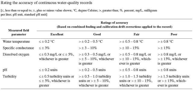
One of four accuracy classifications is applied for measured physical properties at continuous-record stations on a scale ranging from poor to excellent. The accuracy rating is based on data values recorded before any shifts or corrections are made. Additional consideration also is given to the amount of publishable record and to the amount of data that have been corrected or shifted.
[ Back to Main Page ] [ Back to Top ] Arrangement of Records
Water-quality records collected at a surface-water daily record station or a crest-stage partial-record station are published immediately following that record, regardless of the frequency of sample collection. Station number and name are the same for both records. Where a surface-water daily record station is not available or where the water quality differs significantly from that at the nearby surface-water station, the continuing water-quality record is published with its own station number and name in the regular downstream-order sequence. Water-quality data for miscellaneous sampling sites appear in separate tables following the table of discharge measurements at miscellaneous sites. Locations of miscellaneous water-qualitysampling sites for which data are given in this report are shown in the corresponding maps. [ Back to Main Page ] [ Back to Top ] Onsite Measurements and Sample Collection
In obtaining water-quality data, a major concern is assuring that the data obtained represent the naturally occurring quality of the water. To ensure this, certain measurements, such as water temperature, pH, and dissolved oxygen, must be made onsite when the samples are taken. To assure that measurements made in the laboratory also represent the naturally occurring water, carefully prescribed procedures must be followed in collecting the samples, in treating the samples to prevent changes in quality pending analysis, and in shipping the samples to the laboratory. Procedures for onsite measurements and for collecting, treating, and shipping samples are given in TWRIs Book 1, Chapter D2; Book 3, Chapters A1, A3, and A4; and Book 9, Chapters A1-A9. Most of the methods used for collecting and analyzing water samples are described in the TWRIs, which may be accessed from https://pubs.usgs.gov/twri/. Also, detailed information on collecting, treating, and shipping samples can be obtained from the USGS Water Science Center (see the address shown in the ACCESS section of this report). [ Back to Main Page ] [ Back to Top ] Water Temperature
Water temperatures are measured at most of the water-quality stations. In addition, water temperatures are taken at the time of discharge measurements for water-discharge stations. For stations where water temperatures are taken manually once or twice daily, the water temperatures are taken at about the same time each day. Large streams have a small diurnal temperature change; shallow streams may have a daily range of several degrees and may follow closely the changes in air temperature. Some streams may be affected by waste-heat discharges. At stations where recording instruments are used, either mean temperatures or maximum and minimum temperatures for each day are published. Water temperatures measured at the time of water-discharge measurements are on file in the USGS Water Science Center. [ Back to Main Page ] [ Back to Top ] Sediment
Suspended-sediment concentrations are determined from samples collected by using depth-integrating samplers. Samples usually are obtained at several verticals in the cross section, or a single sample may be obtained at a fixed point and a coefficient applied to determine the mean concentration in the cross section. During periods of rapidly changing flow or rapidly changing concentration, samples may be collected more frequently (twice daily or, in some instances, hourly). The published sediment discharges for days of rapidly changing flow or concentration are computed by the subdivided-day method (time-discharge weighted average). Therefore, for those days when the published sediment discharge value differs from the value computed as the product of discharge times mean concentration times 0.0027, the reader can assume that the sediment discharge for that day was computed by the subdivided-day method. For periods when no samples were collected, daily discharges of suspended sediment were estimated on the basis of water discharge, sediment concentrations observed immediately before and after the periods, and suspended-sediment loads for other periods of similar discharge. At other stations, suspended-sediment samples are collected periodically at many verticals in the stream cross section. Although data collected periodically may represent conditions only at the time of observation, such data are useful in establishing seasonal relations between quality and streamflow and in predicting long-term sediment-discharge characteristics of the stream. In addition to the records of suspended-sediment discharge, records of the periodic measurements of the particle-size distribution of the suspended sediment and bed material are included for some stations. [ Back to Main Page ] [ Back to Top ] Laboratory Measurements
Samples for biochemical oxygen demand (BOD) and indicator bacteria are analyzed locally. All other samples are analyzed in the USGS laboratory in Lakewood, Colorado, unless otherwise noted. Methods used in analyzing sediment samples and computing sediment records are given in TWRI, Book 5, Chapter C1. Methods used by the USGS laboratories are given in the TWRIs, Book 1, Chapter D2; Book 3, Chapter C2; and Book 5, Chapters A1, A3, and A4. The TWRI publications may be accessed from https://pubs.usgs.gov/twri/. These methods are consistent with ASTM standards and generally follow ISO standards. [ Back to Main Page ] [ Back to Top ] Data Presentation
For continuing-record stations, information pertinent to the history of station operation is provided in descriptive headings preceding the tabular data. These descriptive headings give details regarding location, drainage area, period of record, type of data available, instrumentation, general remarks, cooperation, and extremes for parameters currently measured daily. Tables of chemical, physical, biological, radiochemical data, and so forth, obtained at a frequency less than daily are presented first. Tables of “daily values” of specific conductance, pH, water temperature, dissolved oxygen, and suspended sediment then follow in sequence. In the descriptive headings, if the location is identical to that of the discharge gaging station, neither the LOCATION nor the DRAINAGE AREA statements are repeated. The following information is provided with each continuous-record station. Comments that follow clarify information presented under the various headings of the station description.
The surface-water-quality records for partial-record stations and miscellaneous sampling sites are published in separate tables following the table of discharge measurements at miscellaneous sites. No descriptive statements are given for these records. Each station is published with its own station number and name in the regular downstream-order sequence. [ Back to Main Page ] [ Back to Top ] Remark Codes
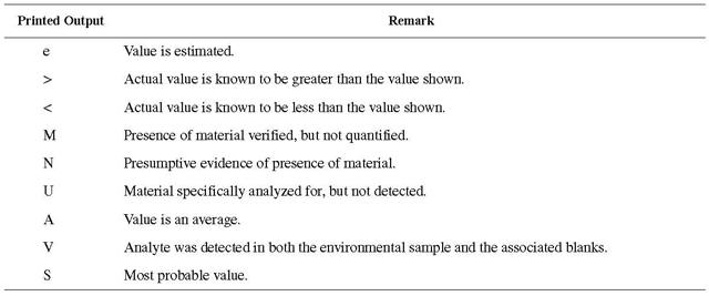
The following remark codes may appear with the water-quality data in this section:
[ Back to Main Page ] [ Back to Top ] Water-Quality Control Data
The USGS National Water Quality Laboratory collects quality-control data on a continuing basis to evaluate selected analytical methods to determine long-term method detection levels (LT-MDLs) and laboratory reporting levels (LRLs). These values are re-evaluated each year on the basis of the most recent quality-control data and, consequently, may change from year to year. This reporting procedure limits the occurrence of false positive error. Falsely reporting a concentration greater than the LT-MDL for a sample in which the analyte is not present is 1 percent or less. Application of the LRL limits the occurrence of false negative error. The chance of falsely reporting a nondetection for a sample in which the analyte is present at a concentration equal to or greater than the LRL is 1 percent or less. Accordingly, concentrations are reported as less than LRL for samples in which the analyte either was not detected or did not pass identification. Analytes detected at concentrations between the LT-MDL and the LRL and that pass identification criteria are estimated. Estimated concentrations will be noted with a remark code of “e.” These data should be used with the understanding that their uncertainty is greater than that of data reported without the “e” remark code. Data generated from quality-control (QC) samples are a requisite for evaluating the quality of the sampling and processing techniques as well as data from the actual samples themselves. Without QC data, environmental sample data cannot be adequately interpreted because the errors associated with the sample data are unknown. The various types of QC samples collected by a USGS Water Science Center are described in the following section. Procedures have been established for the storage of water-quality-control data within the USGS. These procedures allow for storage of all derived QC data and are identified so that they can be related to corresponding environmental samples. These data are not presented in this report but are available from the USGS Water Science Center. [ Back to Main Page ] [ Back to Top ] Blank Samples
Blank samples are collected and analyzed to ensure that environmental samples have not been contaminated in the overall data-collection process. The blank solution used to develop specific types of blank samples is a solution that is free of the analytes of interest. Any measured value signal in a blank sample for an analyte (a specific component measured in a chemical analysis) that was absent in the blank solution is believed to be due to contamination. Many types of blank samples are possible; each is designed to segregate a different part of the overall data-collection process. The types of blank samples collected in this district are:
[ Back to Main Page ] [ Back to Top ] Reference Samples
Reference material is a solution or material prepared by a laboratory. The reference material composition is certified for one or more properties so that it can be used to assess a measurement method. Samples of reference material are submitted for analysis to ensure that an analytical method is accurate for the known properties of the reference material. Generally, the selected reference material properties are similar to the environmental sample properties. [ Back to Main Page ] [ Back to Top ] Replicate Samples
Replicate samples are a set of environmental samples collected in a manner such that the samples are thought to be essentially identical in composition. Replicate is the general case for which a duplicate is the special case consisting of two samples. Replicate samples are collected and analyzed to establish the amount of variability in the data contributed by some part of the collection and analytical process. Many types of replicate samples are possible, each of which may yield slightly different results in a dynamic hydrologic setting, such as a flowing stream. The types of replicate samples collected in this district are:
[ Back to Main Page ] [ Back to Top ] Spike Samples
Spike samples are samples to which known quantities of a solution with one or more well-established analyte concentrations have been added. These samples are analyzed to determine the extent of matrix interference or degradation on the analyte concentration during sample processing and analysis. |
| Accessibility FOIA Privacy Policies and Notices | |
 |
|