PUEBLO COUNTY
382323104200701. SC01906221AAA Pueblo Drought Well
LOCATION.--Lat 38°23'23", long 104°20'09", in NE14NE14NE14 sec.21, T.19 S., R.62 W., Pueblo County, Hydrologic Unit 11020005, 0.1 mi east of DOT Road, 9.0 mi north of U.S. Highway 50, and 20 mi northeast of Pueblo.
AQUIFER.--Terrace deposits.
WELL CHARACTERISTICS.--Drilled, observation well, diameter 2 in., depth 90 ft.
INSTRUMENTATION.--Water-level recorder with satellite telemetry.
DATUM.--Elevation of land-surface datum is 4,843.25 ft above NAVD of 1988. Measuring point: top of 2.4 in. PVC pipe above well casing, 1.10 ft above land-surface datum.
REMARKS.--Daily data that are not published are either missing or of unacceptable quality.
PERIOD OF RECORD.--Daily record from April to September 2003. Intermittent measurements made prior to April 2003 not previously published. For a complete listing of historical data available for this site, see http://waterdata.usgs.gov/co/nwis/inventory/?site_no=382323104200701
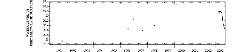
EXTREMES FOR PERIOD OF RECORD.--Highest water level, 19.77 ft below land-surface datum, May 5, 2003; lowest, 21.07 ft, Sep. 27, 1991, from manual measurement.
Depth to water level, feet below land surface
WATER YEAR OCTOBER 2002 TO SEPTEMBER 2003
|
|
|
|
|
|
|
|
|
|
|
|
|
|
|
|
---
|
---
|
---
|
---
|
---
|
---
|
---
|
19.82
|
19.82
|
19.91
|
20.31
|
20.50
|
|
|
---
|
---
|
---
|
---
|
---
|
---
|
---
|
19.81
|
19.82
|
19.92
|
20.31
|
20.50
|
|
|
---
|
---
|
---
|
---
|
---
|
---
|
---
|
19.81
|
19.83
|
19.93
|
20.33
|
20.50
|
|
|
---
|
---
|
---
|
---
|
---
|
---
|
---
|
19.81
|
19.83
|
19.95
|
20.34
|
20.50
|
|
|
---
|
---
|
---
|
---
|
---
|
---
|
---
|
19.80
|
19.83
|
19.95
|
20.34
|
20.51
|
|
|
---
|
---
|
---
|
---
|
---
|
---
|
---
|
19.80
|
19.83
|
19.96
|
20.35
|
20.52
|
|
|
---
|
---
|
---
|
---
|
---
|
---
|
---
|
19.81
|
19.83
|
19.98
|
20.36
|
20.52
|
|
|
---
|
---
|
---
|
---
|
---
|
---
|
---
|
19.80
|
19.83
|
20.00
|
20.36
|
20.52
|
|
|
---
|
---
|
---
|
---
|
---
|
---
|
---
|
19.80
|
19.84
|
20.02
|
20.37
|
20.53
|
|
|
---
|
---
|
---
|
---
|
---
|
---
|
---
|
19.81
|
19.84
|
20.03
|
20.38
|
20.53
|
|
|
---
|
---
|
---
|
---
|
---
|
---
|
---
|
19.81
|
19.84
|
20.05
|
20.39
|
20.53
|
|
|
---
|
---
|
---
|
---
|
---
|
---
|
---
|
19.80
|
19.85
|
20.06
|
20.39
|
20.53
|
|
|
---
|
---
|
---
|
---
|
---
|
---
|
---
|
19.81
|
19.85
|
20.08
|
20.40
|
20.54
|
|
|
---
|
---
|
---
|
---
|
---
|
---
|
19.88
|
19.81
|
19.85
|
20.10
|
20.40
|
20.54
|
|
|
---
|
---
|
---
|
---
|
---
|
---
|
19.87
|
19.80
|
19.86
|
20.12
|
20.41
|
20.54
|
|
|
---
|
---
|
---
|
---
|
---
|
---
|
19.88
|
19.81
|
19.86
|
20.13
|
20.41
|
20.54
|
|
|
---
|
---
|
---
|
---
|
---
|
---
|
19.87
|
19.81
|
19.87
|
20.15
|
20.42
|
20.54
|
|
|
---
|
---
|
---
|
---
|
---
|
---
|
19.87
|
19.80
|
19.87
|
20.17
|
20.43
|
20.54
|
|
|
---
|
---
|
---
|
---
|
---
|
---
|
19.85
|
19.81
|
19.86
|
20.19
|
20.43
|
20.54
|
|
|
---
|
---
|
---
|
---
|
---
|
---
|
19.85
|
19.81
|
19.85
|
20.20
|
20.44
|
20.55
|
|
|
---
|
---
|
---
|
---
|
---
|
---
|
19.85
|
19.81
|
19.85
|
20.21
|
20.45
|
20.55
|
|
|
---
|
---
|
---
|
---
|
---
|
---
|
19.84
|
19.81
|
19.85
|
20.22
|
20.45
|
20.55
|
|
|
---
|
---
|
---
|
---
|
---
|
---
|
19.83
|
19.81
|
19.85
|
20.23
|
20.46
|
20.55
|
|
|
---
|
---
|
---
|
---
|
---
|
---
|
19.83
|
19.81
|
19.86
|
20.24
|
20.46
|
20.56
|
|
|
---
|
---
|
---
|
---
|
---
|
---
|
19.84
|
19.81
|
19.87
|
20.25
|
20.47
|
20.56
|
|
|
---
|
---
|
---
|
---
|
---
|
---
|
19.83
|
19.81
|
19.87
|
20.26
|
20.47
|
20.56
|
|
|
---
|
---
|
---
|
---
|
---
|
---
|
19.83
|
19.82
|
19.87
|
20.27
|
20.48
|
20.56
|
|
|
---
|
---
|
---
|
---
|
---
|
---
|
19.82
|
19.82
|
19.88
|
20.28
|
20.48
|
20.57
|
|
|
---
|
---
|
---
|
---
|
---
|
---
|
19.82
|
19.82
|
19.90
|
20.28
|
20.49
|
20.57
|
|
|
---
|
---
|
---
|
---
|
---
|
---
|
19.82
|
19.82
|
19.90
|
20.29
|
20.49
|
20.59
|
|
|
---
|
---
|
---
|
---
|
---
|
---
|
---
|
19.82
|
---
|
20.30
|
20.49
|
---
|
|
|
---
|
---
|
---
|
---
|
---
|
---
|
---
|
19.81
|
19.85
|
20.12
|
20.41
|
20.54
|
|
|
---
|
---
|
---
|
---
|
---
|
---
|
---
|
19.82
|
19.90
|
20.30
|
20.49
|
20.59
|
|
|
---
|
---
|
---
|
---
|
---
|
---
|
---
|
19.80
|
19.82
|
19.91
|
20.31
|
20.50
|
|