![]()
![]()
By R.M. Crowfoot, R.W. Boulger, and G.B. O'Neill
The Water-Resources Division of the U.S. Geological Survey, in cooperation with State agencies, obtains a large amount of data pertaining to the water resources of Colorado each water year. These data, accumulated during many water years, constitute a valuable data base for developing an improved understanding of the water resources of the State. To make these data readily available to interested parties outside the Geological Survey, the data are published annually in the report series entitled "Water Resources Data - Colorado".
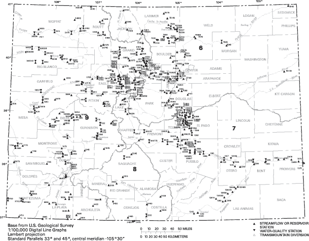
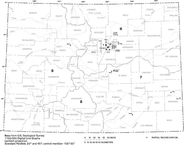
This report (Volume 2 of two volumes) includes records on both surface and ground water in the State, west of the Continental Divide. Specifically, it contains: (1) discharge records for 167 surface-water stations, and peak discharge data for 1 partial-record surface-water station and discharge-measurement data for 1 low-flow partial-record site; (2) stage and contents for 11 lakes and reservoirs; (3) surface-water-quality data for 73 surface-water stations, 4 reservoirs, 44 miscellaneous sites, and miscellaneous surface-water-quality data for 109 gaged sites; and (4) ground-water level records for 2 sites, and meteorological data for 10 sites. Locations of lake and surface-water-gaging stations and surface-water-quality stations are shown in figure 1, locations of crest-stage partial-record stations are shown in figure 2. The data in this report represent that part of the National Water Data System collected by the U.S. Geological Survey and cooperating State and Federal agencies in Colorado.
Prior to introduction of this series and for several water years concurrent with it, water-resources data for Colorado were published in U.S. Geological Survey Water-Supply Papers. Data on stream discharge and stage and on lake or reservoir contents and stage, through September 1960, were published annually under the title "Surface-water Supply of the United States," Parts 6B, 7, 8, and 9. For the 1961 through 1970 water years, the data were published in two 5-year reports. Data on chemical quality, temperature, and suspended sediment for the 1941 through 1970 water years were published annually under the title "Quality of Surface Waters of the United States." Data on ground-water levels for the 1935 through 1955 water years were published annually under the title "Water Levels and Artesian Pressures in Observation Wells in the United States." For the 1956 through 1974 water years the data were published in four 5-year reports under the title "Ground-Water Levels in the United States." Water-supply papers may be purchased from the U.S. Geological Survey, Books and Open-File Reports, Federal Center, Building 810, Box 25425, Denver, CO 80225.
For water years 1961 through 1970, streamflow data were released by the Survey in annual reports on a State-boundary basis. Water-quality records for water years 1964 through 1970 were similarly released either in separate reports or in conjunction with streamflow records.
Publications similar to this report are published annually by the Geological Survey for all States. These official Survey reports carry an identification number consisting of the two-letter State abbreviation, the last two digits of the water year, and the volume number. For example, this volume is identified as "U.S. Geological Survey Water-Data Report CO-03-2." For archiving and general distribution, the reports for 1971-74 water years also are identified as water-data reports. These water-data reports are for sale, in paper copy or in micro-fiche, by the National Technical Information Service, U.S. Department of Commerce, Springfield, VA 22161.
Additional information, including current prices, for ordering specific reports may be obtained from the District office at the address given on the back of the title page or by telephone (303) 236-4882.
 (Click image for larger view.) |
 (Click image for larger view.) |
| Figure 1.--Map showing locations of lake and surface-water stations and surface-water-quality stations in Colorado. | Figure 2.--Map showing locations of crest-stage partial-record stations in Colorado. |
The U.S. Geological Survey and organizations in the State of Colorado have had cooperative agreements for the systematic collection of surface-water records since 1895 and for water-quality records since 1941. Organizations that supported data-collection activities through cooperative agreements with the Survey during the 2003 water year are:
supported data-collection activities through cooperative agreements with the Survey during the 2003 water year are:
| Arapahoe County Water and Wastewater Authority. Arkansas River Compact Administration. Centennial Water and Sanitation District. Cherokee Metropolitan District. City and County of Denver, Board of Water Commissioners. City of Aurora. City of Black Hawk. City of Boulder. City of Brush. City and County of Broomfield. City of Colorado Springs. City of Craig. City of Englewood. City of Fort Collins. City of Fort Morgan. City of Glendale. City of Golden. City of Gunnison. City of Idaho Springs. City of Lakewood. City of Longmont. City of Louisville. City of Loveland. City of Pueblo. City of Steamboat Springs City of Westminster. Clear Creek Board of County Commissioners. Colorado Department of Public Health and Environment. Colorado Division of Parks and Outdoor Recreation. Colorado Division of Water Resources. Colorado Division of Wildlife. Colorado River Water Conservation District. Colorado Springs Utilities. Colorado Water Conservation Board. Crested Butte South Metropolitan District. Custer County. Delta County Board of County Commissioners. Dolores Water Conservancy District. Douglas County. Eagle County Board of Commissioners. Eagle River Water and Sanitation District. East Grand County Water-Quality Board. El Paso County. Evergreen Metropolitan District. |
Fountain Valley Authority. Gilpin County. Grand County. Jefferson County Board of County Commissioners. Lower Fountain Water-Quality Management Association. Meeker Sanitation District. Metro Wastewater Reclamation District. Mount Crested Butte Water and Sanitation District. North Front Range Water Quality Planning Association. Northern Colorado Water Conservancy District. Northwest Colorado Council of Governments. Park County. Plum Creek Wastewater Authority. Pueblo Board of Water Works. Pueblo County. Pueblo West Metropolitan District. Rio Blanco County Board of County Commissioners. Rio Grande Water Conservation District. Southeastern Colorado Water Conservancy District. Southern Ute Indian Tribe. Southwestern Colorado Water Conservation District. St. Charles Mesa Water District. Teller - Park Soil Conservation District. Town of Basalt. Town of Breckenridge. Town of Colbran. Town of Crested Butte. Town of Eagle. Town of Georgetown. Town of Gypsum. Town of Hotchkiss. Town of Meeker. Town of Paonia. Town of Rangely. Trinchera Water Conservancy District. Upper Arkansas River Water Conservancy District. Upper Eagle Regional Water Authority. Upper Gunnison River Water Conservancy District. Upper Yampa Water Conservancy District. Urban Drainage and Flood Control District. Western State College of Colorado. Wyoming State Engineer. Yellowjacket Water Conservancy District. |
Financial assistance was also provided by the U.S. Air Force Academy; U.S. Army, Corps of Engineers; U.S. Army; Bureau of Land Management; Bureau of Reclamation; National Park Service; U.S. Fish and Wildlife Service; and U.S. Forest Service. Organizations that supplied data are acknowledged in station descriptions.
Hydrologic Benchmark Network is a network of 61 sites in small drainage basins in 39 States that was established in 1963 to provide consistent streamflow data representative of undeveloped watersheds nationwide, and from which data could be analyzed on a continuing basis for use in comparison and contrast with conditions observed in basins more obviously affected by human activities. At selected sites, water-quality information is being gathered on major ions and nutrients, primarily to assess the effects of acid deposition on stream chemistry. Additional information on the Hydrologic Benchmark Program may be accessed from http://water.usgs.gov/hbn/.
National Stream-Quality Accounting Network (NASQAN) is a network of sites used to monitor the water quality of large rivers within the Nation's largest river basins. From 1995 through 1999, a network of approximately 40 stations was operated in the Mississippi, Columbia, Colorado, and Rio Grande River basins. For the period 2000 through 2004, sampling was reduced to a few index stations on the Colorado and Columbia Rivers so that a network of 5 stations could be implemented on the Yukon River. Samples are collected with sufficient frequency that the flux of a wide range of constituents can be estimated. The objective of NASQAN is to characterize the water quality of these large rivers by measuring concentration and mass transport of a wide range of dissolved and suspended constituents, including nutrients, major ions, dissolved and sediment-bound heavy metals, common pesticides, and inorganic and organic forms of carbon. This information will be used (1) to describe the long-term trends and changes in concentration and transport of these constituents; (2) to test findings of the National Water-Quality Assessment (NAWQA) Program; (3) to characterize processes unique to large-river systems such as storage and re-mobilization of sediments and associated contaminants; and (4) to refine existing estimates of off-continent transport of water, sediment, and chemicals for assessing human effects on the world's oceans and for determining global cycles of carbon, nutrients, and other chemicals. Additional information about the NASQAN Program may be accessed from http://water.usgs.gov/nasqan/.
The National Atmospheric Deposition Program/National Trends Network (NADP/NTN) is a network of monitoring sites that provide continuous measurement and assessment of the chemical constituents in precipitation throughout the United States. As the lead Federal agency, the USGS works together with over 100 organizations to provide a long-term, spatial and temporal record of atmospheric deposition generated from this network of 250 precipitation-chemistry monitoring sites. The USGS supports 74 of these 250 sites. This long-term, nationally consistent monitoring program, coupled with ecosystem research, provides critical information toward a national scorecard to evaluate the effectiveness of ongoing and future regulations intended to reduce atmospheric emissions and subsequent impacts to the Nation's land and water resources. Reports and other information on the NADP/NTN Program, as well as data from the individual sites, may be accessed from http://bqs.usgs.gov/acidrain/.
The USGS National Water-Quality Assessment (NAWQA) Program is a long-term program with goals to describe the status and trends of water-quality conditions for a large, representative part of the Nation's ground- and surface-water resources; to provide an improved understanding of the primary natural and human factors affecting these observed conditions and trends; and to provide information that supports development and evaluation of management, regulatory, and monitoring decisions by other agencies.
Assessment activities are being conducted in 42 study units (major watersheds and aquifer systems) that represent a wide range of environmental settings nationwide and that account for a large percentage of the Nation's water use. A wide array of chemical constituents is measured in ground water, surface water, streambed sediments, and fish tissues. The coordinated application of comparative hydrologic studies at a wide range of spatial and temporal scales will provide information for water-resources managers to use in making decisions and a foundation for aggregation and comparison of findings to address water-quality issues of regional and national interest.
Communication and coordination between USGS personnel and other local, State, and Federal interests are critical components of the NAWQA Program. Each study unit has a local liaison committee consisting of representatives from key Federal, State, and local water-resources agencies, Indian nations, and universities in the study unit. Liaison committees typically meet semiannually to discuss their information needs, monitoring plans and progress, desired information products, and opportunities to collaborate efforts among the agencies. Additional information about the NAWQA Program may be accessed from http://water.usgs.gov/nawqa/.
The USGS National Streamflow Information Program (NSIP) is a long-term program with goals to provide framework streamflow data across the Nation. Included in the program are creation of a permanent Federally funded streamflow network, research on the nature of streamflow, regional assessments of streamflow data and databases, and upgrades in the streamflow information delivery systems. Additional information about NSIP may be accessed from http://water.usgs.gov/nsip/.
The surface-water, ground-water, and precipitation records published in this report are for the 2003 water year that began on October 1, 2002, and ended September 30, 2003. A calendar of the water year is provided on the inside of the front cover. The records contain streamflow data, stage and content data for lakes and reservoirs, ground-water level data, water-quality data for surface and ground water, and precipitation data. The locations of the stations where the surface-water data were collected are shown in figures 1 and 2. The following sections of the introductory text are presented to provide users with a more detailed explanation of how the hydrologic data published in this report were collected, analyzed, computed, and arranged for presentation.
Each data station, whether streamsite or well, in this report is assigned a unique identification number. This number is unique in that it applies specifically to a given station and to no other. The number usually is assigned when a station is first established and is retained for that station indefinitely. The systems used by the U.S. Geological Survey to assign identification numbers for surface-water stations and for ground-water well sites differ, but both are based on geographic location. The "downstream order" system is used for regular surface-water stations and the "latitude-longitude" system is used for wells and, in Colorado, for surface-water stations where only infrequent measurements are made.
Since October 1, 1950, the order of listing hydrologic-station records in Survey reports is in a downstream direction along the main stream. All stations on a tributary entering upstream from a mainstream station are listed before that station. A station on a tributary that enters between two mainstream stations is listed between them. A similar order is followed in listing stations on first rank, second rank, and other ranks of tributaries. The rank of any tributary with respect to the stream to which it is immediately tributary is indicated by an indention in the "List of Stations" in the front of this report. Each indention represents one rank. This downstream order and system of indention show which stations are on tributaries between any two stations and the rank of the tributary on which each station is situated.
The station-identification number is assigned according to downstream order. In assigning station numbers, no distinction is made between partial-record stations and other stations; therefore, the station number for a partial-record station indicates downstream-order position in a list made up of both types of stations. Gaps are left in the series of numbers to allow for new stations that may be established; hence, the numbers are not consecutive. The complete eight-digit number for each station, such as 06614800, which appears just to the left of the station name, includes the two-digit Part number "06" plus the six-digit downstream-order number "614800." The Part number designates the major river basin; for example, Part "06" is the Missouri River basin.
The identification numbers for wells, springs, and miscellaneous surface-water sites are assigned according to the grid system of latitude and longitude. The number consists of 15 digits. The first six digits denote the degrees, minutes, and seconds of latitude, the next seven digits denote the degrees, minutes, and seconds of longitude, and the last two digits (assigned sequentially) identify the wells or other sites within a 1-second grid. This site-identification number, once assigned, is a pure number, and may have no locational significance. In the rare instance where the initial determination of latitude and longitude are found to be in error, the station will retain its initial identification number; however, its true latitude and longitude will be listed in the LOCATION paragraph of the station description.
System for numbering wells, springs, and miscellaneous sites.
The local well number locates a well within a 10-acre tract using the U.S. Bureau of Land Management system of land subdivision. The components of the local well number proceed from the largest to the smallest land subdivisions. This is in contrast to the legal description, which proceeds from the smallest to the largest land subdivision. The largest subdivision is the survey. Colorado is governed by three surveys: The Sixth Principal Meridian Survey (S), the New Mexico Survey (N), and the Ute Survey (U). Costilla County was not included in any of the above official surveys. This report follows the convention of the Costilla County Assessor in which the northern part of the county is governed by the Sixth Principal Meridian Survey and the southern part of the county is governed by a local system called the Costilla Survey (C). The first letter of the well location designates the survey.
A survey is subdivided into four quadrants formed by the intersection of the baseline and the principal meridian. The second letter of the well location designates the quadrant: A indicates the northeast quadrant, B the northwest, C the southwest, and D the southeast. A quadrant is subdivided in the north-south direction every 6 mi by townships and is divided in the east-west direction every 6 mi by ranges. The first number of the well location designates the township and the second number designates the range.
The 36-mi2 area described by the township and range designation is subdivided into 1-mi2 areas called sections. The sections are numbered sequentially. The third number of the well location designates the section. The section, which contains 640 acres, is subdivided into quarter sections. The 160-acre area is designated by the first letter following the section: A indicates the northeast quarter, B the northwest, C the southwest, and D the southeast. The quarter section is subdivided into quarter-quarter sections. The 40-acre area is designated in the same manner by the second letter following the section. The 10-acre area is designated in the same manner by the third letter following the section. If more than one well is located within the 10-acre tract, the wells are numbered sequentially in the order in which they were originally inventoried. If this number is necessary, it will follow the three-letter designation.
Records of stage and water discharge may be complete or partial. Complete records of discharge are those obtained using a continuous stage-recording device through which either instantaneous or mean daily discharges may be computed for any time, or any period of time, during the period of record. Complete records of lake or reservoir content, similarly, are those for which stage or content may be computed or estimated with reasonable accuracy for any time, or period of time. They may be obtained using a continuous stage-recording device, but need not be. Because daily mean discharges and end-of-day contents commonly are published for such stations, they are referred to as "daily stations."
By contrast, partial records are obtained through discrete measurements without using a continuous stage-recording device and pertain only to a few flow characteristics, or perhaps only one. The nature of the partial record is indicated by table titles. Records of miscellaneous discharge measurements or of measurements from special studies may be considered as partial records, but they are presented separately in this report. Location of all complete-record stations for which data are given in this report are shown in figure 1.
The data obtained at a complete-record gaging station on a stream or canal consist of a continuous record of stage, individual measurements of discharge throughout a range of stages, and notations regarding factors that may affect the relationships between stage and discharge. These data, together with supplemental information, such as weather records, are used to compute daily discharges. The data obtained at a complete-record gaging station on a lake or reservoir consist of a record of stage and of notations regarding factors that may affect the relationship between stage and lake content. These data are used with stage-area and stage-capacity curves or tables to compute water-surface areas and lake storage.
Continuous records of stage are obtained with analog recorders that trace continuous graphs of stage, with digital recorders that punch stage values on paper tapes at selected time intervals, with electronic recorders that store stage values on computer chips at selected time intervals, or with satellite data-collection platforms that transmit near real-time data at selected time intervals to office computers. Measurements of discharge are made with current meters using methods adapted by the Geological Survey as a result of experience accumulated since 1880. These methods are described in standard textbooks, in Water-Supply Paper 2175, and in U.S. Geological Survey Techniques of Water-Resources Investigations, Book 3, Chapter A6.
In computing discharge records, results of individual measurements are plotted against the corresponding stages, and stage-discharge relation curves are then constructed. From these curves, rating tables indicating the approximate discharge for any stage within the range of the measurements are prepared. If it is necessary to define extremes of discharge outside the range of the current-meter measurements, the curves are extended using: (1) logarithmic plotting; (2) velocity-area studies; (3) results of indirect measurements of peak discharge, such as slope-area or contracted-opening measurements, and computations of flow over dams or weirs; or (4) step-backwater techniques.
Daily mean discharges are computed by applying the daily mean stages (gage heights) to the stage-discharge curves or tables. If the stage-discharge relation is subject to change because of frequent or continual change in the physical features that form the control, the daily mean discharge is determined by the shifting-control method, in which correction factors based on the individual discharge measurements and notes of the personnel making the measurements are applied to the gage heights before the discharges are determined from the curves or tables. This shifting-control method also is used if the stage-discharge relation is changed temporarily because of aquatic growth or debris on the control. For some stations, formation of ice in the winter may obscure the stage-discharge relations that daily mean discharges must be estimated from other information such as temperature and precipitation records, notes of observations, and records for other stations in the same or nearby basins for comparable periods.
At some stream-gaging stations the stage-discharge relation is affected by the backwater from reservoirs, tributary streams, or other sources. This necessitates the use of the slope method in which the slope or fall in a reach of the stream is a factor in computing discharge. The slope or fall is obtained by means of an auxiliary gage set at some distance from the base gage. At some stations the stage-discharge relation is affected by changing stage; at these stations the rate of change in stage is used as a factor in computing discharge.
In computing records of lake or reservoir contents, it is necessary to have available from surveys, curves, or tables defining the relationship of stage and content. The application of stage to the stage-content curves or tables gives the contents from which daily, monthly, or yearly changes then are determined. If the stage-content relationship changes because of deposition of sediment in a lake or reservoir, periodic resurveys may be necessary to redefine the relationship. Even when this is done, the contents computed may become increasingly in error as time since the last survey increases. Discharges over lake or reservoir spillways are computed from stage-discharge relationships much as other stream discharges are computed.
For some gaging stations there are periods when no gage-height record is obtained, or the recorded gage height is so faulty that it cannot be used to compute daily discharge or contents. This happens when the recorder stops or otherwise fails to operate properly, intakes are plugged, the float is frozen in the well, or for various other reasons. For such periods, the daily discharges are estimated from the recorded range in stage, previous or following record, discharge measurements, weather records, and comparison with other station records from the same or nearby basins. Likewise, daily contents may be estimated from operator's logs, previous or following record, inflow-outflow studies, and other information. Information explaining how estimated daily-discharge values are identified in station records is included in the next two sections. "Data Presentation" (REMARKS paragraph) and "Identifying Estimated Daily Discharge."
Streamflow data in this report are presented in a new format that is considerably different from the format in data reports prior to the 1992 water year. The major changes are that statistical characteristics of discharge now appear in tabular summaries following the water-year data table and less information is provided in the text or station manuscript above the table. These changes represent the results of a pilot program to reformat the annual water-data report to meet current user needs and data preferences.
The records published for each continuous-record surface-water discharge station (gaging station) now consist of four parts, the manuscript or station description and the data table of daily mean values of discharge for the current water year with summary data; a tabular statistical summary of monthly mean flow data for a designated period, by water year; and a summary statistics table that includes statistical data of annual, daily, and instantaneous flow as well as data pertaining to annual runoff, 7-day low-flow minimums, and flow duration.
The manuscript provides, under various headings, descriptive information, such as station location; period of record; historical extremes outside the period of record; record accuracy; and other remarks pertinent to station operation and regulation. The following information, as appropriate, is provided with each continuous record of discharge or lake content. Comments to follow clarify information presented under the various headings of the station description.
LOCATION.--Information on locations is obtained from the most accurate maps available. The location of the gaging station with respect to the cultural and physical features in the vicinity and with respect to the reference place mentioned in the station name is given. River mileages, given for only a few stations, were determined by methods given in "River Mileage Measurement," Bulletin 14, Revision of October 1968, prepared by the Water Resources Council or were provided by the U.S. Army Corps of Engineers.
DRAINAGE AREA.--Drainage areas are measured using the most accurate maps available. Because the type of maps available varies from one drainage basin to another, the accuracy of drainage areas likewise varies. Drainage areas are updated as better maps become available.
PERIOD OF RECORD.--This indicates the period for which there are published records for the station or for an equivalent station. An equivalent station is one that was in operation at a time that the present station was not, and whose location was such that flow at it can reasonably be considered equivalent with records from the present station.
REVISED RECORDS.--Because of new information, published records occasionally are found to be incorrect, and revisions are printed in later reports. Listed under this heading are all the reports in which revisions have been published for the station and the water years to which the revisions apply. If a revision did not include daily, monthly, or annual figures of discharge, that fact is noted after the year dates as follows: "(M)" means that only the instantaneous maximum discharge was revised; "(m)" that only the instantaneous minimum was revised; and "(P)" that only peak discharges were revised. If the drainage area has been revised, the report in which the most recently revised figure was first published is given.
GAGE.--The type of gage in current use, the datum of the current gage referred to sea level (see glossary), and a condensed history of the types, locations, and datums of previous gages are given under this heading.
REMARKS.--All periods of estimated daily-discharge record will either be identified by date in this paragraph of the station description for water-discharge stations or flagged in the daily-discharge table. (See next section, "Identifying Estimated Daily Discharge.") If a REMARKS paragraph is used to identify estimated record, the paragraph will begin with this information presented as the first entry. The paragraph is also used to present information relative to the accuracy of the records, to special methods of computation, to conditions that affect natural flow at the station. In addition, information may be presented pertaining to average discharge data for the period of record; to extremes data for the period of record and the current year; and, possibly, to other pertinent items. For reservoir stations, information is given on the dam forming the reservoir, the capacity, outlet works and spillway, and purpose and use of the reservoir.
COOPERATION.--Records provided by a cooperating organization or obtained for the Geological Survey by a cooperating organization are identified here.
EXTREMES OUTSIDE PERIOD OF RECORD.--Included here is information concerning major floods or unusually low flows that occurred outside the stated period of record. The information may or may not have been obtained by the U.S. Geological Survey.
REVISIONS.--If a critical error in published records is discovered, a revision is included in the first report published following discovery of the error.
Although rare, occasionally the records of a discontinued gaging station may need revision. Because, for these stations, there would be no current or, possibly, future station manuscript published to document the revision in a "Revised Records" entry, users of data for these stations who obtained the record from previously published data reports may wish to contact the District office (address given on the back of the title page of this report) to determine if the published records were ever revised after the station was discontinued. Of course, if the data for a discontinued station were obtained by computer retrieval, the data would be current and there would be no need to check because any published revision of data is always accompanied by revision of the corresponding data in computer storage.
Manuscript information for lake or reservoir stations differs from that for stream stations in the nature of the "Remarks" and in the inclusion of a skeleton stage-capacity table when daily contents are given.
Headings for AVERAGE DISCHARGE, EXTREMES FOR PERIOD OF RECORD, AND EXTREMES FOR CURRENT YEAR have been deleted and the information contained in these paragraphs, except for the listing of secondary instantaneous peak discharges in the EXTREMES FOR CURRENT YEAR paragraph, is now presented in the tabular summaries following the discharge table or in the REMARKS paragraph, as appropriate. No changes have been made to the data presentations of lake contents.
The daily table of discharge records for stream-gaging stations gives mean discharge for each day of the water year. In the monthly summary below the daily table, the line headed "TOTAL" gives the sum of the daily figures for each month; the line headed "MEAN" gives the average flow in cubic feet per second during the month; and the lines headed "MAX" and "MIN" give the maximum and minimum daily mean discharges, respectively, for each month. Discharge for the month also is usually expressed in cubic feet per second per square mile (line headed "CFSM"), or in inches (line headed "IN"), or in acre-feet (line headed "AC-FT"). Figures for cubic feet per second per square mile and runoff in inches or in acre-feet may be omitted if there is extensive regulation or diversion or if the drainage area includes large noncontributing areas. In the yearly summary below the monthly summary, the figures shown are the appropriate discharges for the calendar and water years. At some stations monthly and (or) yearly observed discharges are adjusted for reservoir storage or diversion, or diversions or reservoir contents are given. These figures are identified by a symbol and corresponding footnote.
If applicable, data collected at partial-record stations follow the information for continuous-record sites. The tables of partial-record stations are followed by a listing of discharge measurements made at sites other than continuous-record or partial-record stations. These measurements are generally made in times of drought or flood to give better areal coverage to those events. Those measurements and others collected for some special reason are called measurements at miscellaneous sites.
A tabular summary of the mean (line headed "MEAN"), maximum (line headed "MAX"), and minimum (line headed "MIN") of monthly mean flows for each month for a designated period is provided below the mean values table. The water years of the first occurrence of the maximum and minimum monthly flows are provided immediately below those figures. The designated period will be expressed as "FOR WATER YEARS______-______, BY WATER YEAR (WY)," and will list the first and last water years of the range of years selected from the PERIOD OF RECORD paragraph in the station manuscript. It will consist of all of the station record within the specified water years, inclusive, including complete months of record for partial water years, if any, and may coincide with the period of record for the station. The water years for which the statistics are computed will be consecutive, unless a break in the station record is indicated in the manuscript.
A table titled "SUMMARY STATISTICS" follows the statistics of monthly mean data tabulation. This table consists of four columns, with the first column containing the line headings of the statistics being reported. The table provides a statistical summary of yearly, daily, and instantaneous flows, not only for the current water year but also for the previous calendar year and for a designated period, as appropriate. The designated period selected, "WATER YEARS______-______," will consist of all of the station record within the specified water years, inclusive, including complete months of record for partial water years, if any, and may coincide with the period of record for the station. The water years for which the statistics are computed will be consecutive, unless a break in the station record is indicated in the manuscript. All of the calculations for the statistical characteristics designated ANNUAL (see line headings below), except for the "ANNUAL 7-DAY MINIMUM" statistic, are calculated for the designated period using complete water years. The other statistical characteristics may be calculated using partial water years.
The date or water year, as appropriate, of the first occurrence of each statistic reporting extreme values of discharge is provided adjacent to the statistic. Repeated occurrences may be noted in the REMARKS paragraph of the manuscript or in footnotes. Because the designated period may not be the same as the station period record published in the manuscript, occasionally the dates of occurrence listed for the daily and instantaneous extremes in the designated-period column may not be within the selected water years listed in the heading. When this occurs, it will be noted in the REMARKS paragraph or in footnotes. Selected streamflow duration curve statistics and runoff data are also given. Runoff data may be omitted if there is extensive regulation or diversion of flow in the drainage basin.
The following summary statistics data, as appropriate, are provided with each continuous record of discharge. Comments to follow clarify information presented under the various line headings of the summary statistics table.
ANNUAL TOTAL.--The sum of the daily mean values of discharge for the year. At some stations the annual total discharge is adjusted for reservoir storage or diversion. The adjusted figures are identified by a symbol and corresponding footnotes.
ANNUAL MEAN.--The arithmetic mean of the individual daily mean discharges for the year noted or for the designated period. At some stations the yearly mean discharge is adjusted for reservoir storage or diversion. The adjusted figures are identified by a symbol and corresponding footnotes.
HIGHEST ANNUAL MEAN.--The maximum annual mean discharge occurring for the designated period.
LOWEST ANNUAL MEAN.--The minimum annual mean discharge occurring for the designated period.
HIGHEST DAILY MEAN.--The maximum daily mean discharge for the year or for the designated period.
LOWEST DAILY MEAN.--The minimum daily mean discharge for the year or for the designated period.
ANNUAL 7-DAY MINIMUM.--The lowest mean discharge for 7 consecutive days for a calendar year or a water year. Note that most low-flow frequency analyses of annual 7-day minimum flows use a climatic year (April 1-March 31). The date shown in the summary statistics table is the initial date of the 7-day period. (This value should not be confused with the 7-day 10-year low-flow statistic.)
MAXIMUM PEAK FLOW.-- The maximum instantaneous peak discharge occurring for the water year or designated period. Occasionally the maximum flow for a year may occur at midnight at the beginning or end of the year, on a recession from or rise toward a higher peak in the adjoining year. In this case, the maximum peak flow is given in the table and the maximum flow may be reported in a footnote or in the REMARKS paragraph in the manuscript.
MAXIMUM PEAK STAGE.-- The maximum instantaneous peak stage occurring for the water year or designated period. Occasionally the maximum stage for a year may occur at midnight at the beginning or end of the year, on a recession from or rise toward a higher peak in the adjoining year. In this case, the maximum peak stage is given in the table and the maximum stage may be reported in the REMARKS paragraph in the manuscript or in a footnote. If the dates of occurrence of the maximum peak stage and maximum peak flow are different, the REMARKS paragraph in the manuscript or a footnote may be used to provide further information.
INSTANTANEOUS LOW FLOW.--The minimum instantaneous discharge occurring for the water year or for the designated period.
ANNUAL RUNOFF.--Indicates the total quantity of water in runoff for a drainage area for the year. Data reports may use any of the following units of measurement in presenting annual runoff data:
10 PERCENT EXCEEDS.--The discharge that has been exceeded 10 percent of the time for the designated period.
50 PERCENT EXCEEDS.--The discharge that has been exceeded 50 percent of the time for the designated period.
90 PERCENT EXCEEDS.--The discharge that has been exceeded 90 percent of the time for the designated period.
Data collected at partial-record stations follow the information for continuous-record sites. Data for partial-record discharge stations are presented in two tables. The first is a table of annual maximum stage and discharge at crest-stage stations, and the second is a table of discharge measurements at low-flow partial-record stations. The tables of partial-record stations are followed by a listing of discharge measurements made at sites other than continuous-record or partial-record stations. These measurements are generally made in times of drought or flood to give better areal coverage to those events. Those measurements and others collected for some special reason are called measurements at miscellaneous sites.
Estimated daily-discharge values published in the water-discharge tables of annual State data reports are identified either by flagging individual daily values with the letter symbol "e" and printing a table footnote, "e Estimated," or by listing the dates of estimated record in the REMARKS paragraph of the station description.
The accuracy of streamflow records depends primarily on: (1) The stability of the stage-discharge relation or, if the control is unstable, the frequency of discharge measurements; and (2) the accuracy of measurements of stage, measurements of discharge, and interpretation of records.
The accuracy attributed to the records is indicated under "REMARKS." "Excellent" means that about 95 percent of the daily discharges are within 5 percent of their true value; "good," within 10 percent; and "fair," within 15 percent. Records that do not meet the criteria mentioned, are rated "poor." Different accuracies may be attributed to different parts of a given record.
Daily mean discharges in this report are given to the nearest hundredth of a cubic foot per second for daily values less than 1 ft3/s; to the nearest tenth between 1.0 and 10 ft3/s; to whole numbers between 10 and 1,000 ft3/s; and to 3 significant figures for more than 1,000 ft3/s. The number of significant figures used is based solely on the magnitude of the discharge value. The same rounding rules apply to discharges listed for partial-record stations and miscellaneous sites.
Discharge at many stations, as indicated by the monthly mean, may not reflect natural runoff due to the effects of diversion, consumption, regulation by storage, increase or decrease in evaporation due to artificial causes, or to other factors. Evaporation from a reservoir is not included in the adjustments for changes in reservoir contents, unless it is so stated. Even at those stations where adjustments are made, large errors in computed runoff may occur if adjustments or losses are large in comparison with the observed discharge.
The National Water Data Exchange (NAWDEX), U.S. Geological Survey, Reston, VA 22092, maintains an index of records of discharge collected by other agencies but not published by the Geological Survey. Information on records at specific sites can be obtained from that office upon request.
Information used in the preparation of the records in this publication, such as discharge-measurement notes, gage-height records, temperature measurements, and rating tables are on file in the Colorado District office. Information on the availability of the unpublished information or on the results of statistical analyses of the published records may be obtained from the District office.
Records of surface-water quality ordinarily are obtained at or near stream-gaging stations because interpretation of records of surface-water quality nearly always requires corresponding discharge data. Records of surface-water quality in this report may involve a variety of types of data and measurement frequencies.
In March 1989 the National Water-Quality Laboratory discovered a bias in the turbidimetric method for sulfate analysis, indicating that values below 75 mg/L have a median positive bias of 2 mg/L above the true value for the period between 1982 and 1989.
On October 1, 1995, the Colorado District adopted a new sampling and quality-assurance protocol for sampling of surface waters (Horowitz and others, 1994). This protocol was adopted as standard operating procedure for the collection and processing of all trace-element, major-ion, nutrient, and radiochemical species in filtered, surface-water samples.
One of four accuracy classifications is applied for measured physical properties at continuous-record stations on a scale ranging from poor to excellent. The accuracy rating is based on data values recorded before any shifts or corrections are made, as described by Wagner and others (2000). Additional consideration also is given to the amount of publishable record and to the amount of data that have been corrected or shifted.
Measured physical property |
Ratings |
|||
Excellent |
Good |
Fair |
Poor |
|
Water temperature |
£ ± 0.2 °C |
> ± 0.2 to 0.5 °C |
> ± 0.5 to 0.8 °C |
> ± 0.8 °C |
Specific conductance |
£ ± 3% |
> ± 3 to 10% |
> ± 10 to 15% |
> ± 15% |
Dissolved oxygen |
£ ± 0.3 mg/L |
> ± 0.3 to 0.5 mg/L |
> ± 0.5 to 0.8 mg/L |
> ± 0.8 mg/L |
pH |
£ ± 0.2 unit |
> ± 0.2× to 0.5 unit |
> ± 0.5 to 0.8 unit |
> ± 0.8 unit |
Turbidity |
£ ± 5% |
> ± 5 to 10% |
> ± 10 to 15% |
> ± 15% |
Water-quality data for surface-water sites are grouped into one of three classifications. A continuing-record station is a site where data are collected on a regularly scheduled basis. Frequency may be once or more times daily, weekly, monthly, or quarterly. A partial-record station is a site where limited water-quality data are collected systematically over a period of years. Frequency of sampling is usually less than quarterly. A miscellaneous sampling site is a location other than a continuing or partial-record station, where random samples are collected to give better areal coverage to define water-quality conditions in the river basin.
A careful distinction needs to be made between "continuing records" as used in this report and "continuous recordings," which refers to a continuous graph or a series of discrete values punched or recorded at short intervals on a paper tape, magnetic tape, computer chip, or some other medium. Some records of water quality, such as temperature and specific conductance, may be obtained through continuous recordings; however, because of costs, most data are obtained only monthly or less frequently. Locations of stations for which records on the quality of surface water appear in this report are shown in figure 1.
Water-quality records collected at a surface-water daily record station are published immediately following that record, regardless of the frequency of sample collection. Station number and name are the same for both records. Where a surface-water daily record station is not available or where the water quality differs significantly from that at the nearby surface-water station, the continuing water-quality record is published with its own number and name in the regular downstream-order sequence. Water-quality data for partial-record stations and for miscellaneous sampling sites appear in separate tables following the "Supplemental Water-Quality Data For Gaging Stations" Section.
In obtaining water-quality data, a major concern needs to be assuring that the data obtained represent the in situ quality of the water. To assure this, certain measurements, such as water temperature, pH, and dissolved oxygen, need to be made onsite when the samples are taken. To assure that measurements made in the laboratory also represent the in situ water, carefully prescribed procedures need to be followed in collecting the samples, in treating the samples to prevent changes in quality pending analysis, and in shipping the samples to the laboratory. Procedures for onsite measurements and for collecting, treating, and shipping samples are given in publications on "Techniques of Water-Resources Investigations," Book 1, Chap. D2; Book 3, Chap. C2; Book 5, Chap. A1, A3, and A4; Book 9, Chap. A1-A9. All of these references are listed on pages 30 and 31 of this report. Also, detailed information on collecting, treating, and shipping samples may be obtained from the Geological Survey District office.
One sample can define adequately the water quality at a given time if the mixture of solutes throughout the stream cross section is homogeneous. However, the concentration of solutes at different locations in the cross section may vary widely with different rates of water discharge, depending on the source of material and the turbulence and mixing of the stream. Some streams must be sampled through several vertical sections to obtain a representative sample needed for an accurate mean concentration and for use in calculating load. All samples obtained for the National Stream Quality Accounting Network (see definitions) are obtained from at least several verticals. Whether samples are obtained from the centroid of flow or from several verticals, depends on flow conditions and other factors which must be evaluated by the collector.
Chemical-quality data published in this report are considered to be the most representative values available for the stations listed. The values reported represent water-quality conditions at the time of sampling as much as possible, consistent with available sampling techniques and methods of analysis. In the rare case where an apparent inconsistency exists between a reported pH value and the relative abundance of carbon dioxide species (carbonate and bicarbonate), the inconsistency is the result of a slight uptake of carbon dioxide from the air by the sample between measurement of pH in the field and determination of carbonate and bicarbonate in the laboratory.
For chemical-quality stations equipped with digital monitors, the records consist of daily maximum, minimum, and mean values for each constituent measured and are based upon hourly punches beginning at 0100 hours and ending at 2400 hours for the day of record. More detailed records (hourly values) may be obtained from the U.S.G.S. District Office whose address is given on the back of the title page of this report.
Water temperatures are measured at most of the water-quality stations. In addition, water temperatures are taken at time of discharge measurements for water-discharge stations. For stations where water temperatures are taken manually once or twice daily, the water temperatures are taken at about the same time each day. Large streams have a small diurnal temperature change; shallow streams may have a daily range of several degrees and may follow closely the changes in air temperature. Some streams may be affected by waste-heat discharges.
At stations where recording instruments are used, either mean temperatures or maximum and minimum temperatures for each day are recorded to the nearest 0.1 degree Celsius. Water temperatures measured at the time of water-discharge measurements are published in this report as supplemental water-quality for gaging stations.
Suspended-sediment concentrations are determined from samples collected by using depth-integrating samplers. Samples usually are obtained at several verticals in the cross section, or a single sample may be obtained at a fixed point and a coefficient applied to determine the mean concentration in the cross sections.
During periods of rapidly changing flow or rapidly changing concentration, samples may have been collected more frequently (twice daily or, in some instances, hourly). The published sediment discharges for days of rapidly changing flow or concentration were computed by the subdivided-day method (time-discharge weighted average). Therefore, for those days when the published sediment discharge value differs from the value computed as the product of discharge times mean concentration times 0.0027, the reader can assume that the sediment discharge for that day was computed by the subdivided-day method. For periods when no samples were collected, daily discharges of suspended sediment were estimated on the basis of water discharge, sediment concentrations observed immediately before and after the periods, and suspended-sediment loads for other periods of similar discharge.
At other stations, suspended-sediment samples were collected periodically at many verticals in the stream cross section. Although data collected periodically may represent conditions only at the time of observations, such data are useful in establishing seasonal relations between quality and streamflow and in predicting long-term sediment discharge characteristics of the stream.
In addition to the records of suspended-sediment discharge, records of the periodic measurements of the particle-size distribution of the suspended sediment and bed material are included for some stations.
Miscellaneous water-quality data refers to measurements of water temperature and specific conductance that are made in streams concurrently with discharge measurements. Miscellaneous water-quality measurements typically are made at an individual point in a stream cross section. If the stream is well mixed and its chemistry is relatively uniform, a single point measurement may be sufficient to represent the stream cross section. Point measurements of water temperature and specific conductance in streams that are not well mixed may not be representative of the cross section.
Sediment samples, samples for biochemical-oxygen demand (BOD), samples for indicator bacteria, and daily samples for specific conductance are analyzed locally, most other samples are analyzed in the Geological Survey laboratories in Lakewood, CO. Methods used in analyzing sediment samples and computing sediment records are given in TWRI, Book 5, Chap. C1. Methods used by the Geological Survey laboratories are given in TWRI, Book 1, Chap. D2; Book 3, Chap. C2; Book 5, Chap. A1, A3, and A4.
Historical and current-year dissolved trace-element concentrations are reported herein for water that was collected, processed, and analyzed by using either ultraclean or other than ultraclean techniques. If ultraclean techniques were used, then those concentrations are reported in nanograms per liter. If other than ultraclean techniques were used, then those concentrations are reported in micrograms per liter and could reflect contamination introduced during some phase of the procedure.
The USGS National Water Quality Laboratory collects quality-control data on a continuing basis to evaluate selected analytical methods to determine long-term method detection levels (LT-MDL's) and laboratory reporting levels (LRL's). These values are re-evaluated each year on the basis of the most recent quality-control data and, consequently, may change from year to year.
This reporting procedure limits the occurrence of false positive error. The chance of falsely reporting a concentration greater than the LT-MDL for a sample in which the analyte is present is 1 percent or less. Application of the LRL limits the occurrrence of false negative error. The chance of falsely reporting a non-detection for a sample in which the analyte is present at a concentration equal to or greater than the LRL is 1 percent or less.
Accordingly, concentrations are reported as <LRL for samples in which the analyte was either not detected or did not pass identification. Analytes that are detected at concentrations between the LT-MDL and LRL and that pass identification criteria are estimated. Estimated concentrations will be noted with a remark code of "E". These data should be used with the understanding that their uncertainty is greater than that of data reported without the "E" remark code.
For continuing-record stations, information pertinent to the history of station operation is provided in descriptive headings preceding the tabular data. These descriptive headings give details regarding location, drainage area, period of record, type of data available, instrumentation, general remarks, cooperation, and extremes for parameters currently measured daily. Tables of chemical, physical, biological, radiochemical data, and so forth, obtained at a frequency less than daily are presented first. Tables of "daily values" of specific conductance, pH, water temperature, dissolved oxygen, and suspended sediment then follow in sequence.
In the descriptive headings, if the location is identical to that of the discharge gaging station, neither the LOCATION nor the DRAINAGE AREA statements are repeated. The following information, as appropriate, is provided with each continuous-record station. Comments that follow clarify information presented under the various headings of the station description.
LOCATION.--See Data Presentation under "Records of Stage and Water Discharge;" same comments apply.
DRAINAGE AREA.--See Data Presentation under "Records of Stage and Water Discharge;" same comments apply.
PERIOD OF RECORD.--This indicates the periods for which there are published water-quality records for the station. The periods are shown separately for records of parameters measured daily or continuously and those measured less than daily. For those measured daily or continuously, periods of record are given for the parameters individually.
INSTRUMENTATION.--Information on instrumentation is given only if a water-quality monitor temperature record, sediment pumping sampler, or other sampling device is in operation at a station.
REMARKS.--Remarks provide added information pertinent to the collection, analysis, or computation of the records.
COOPERATION.--Records provided by a cooperating organization or obtained for the Geological Survey by a cooperating organization are identified here.
EXTREMES.--Maximums and minimums are given only for parameters measured daily or more frequently. None are given for parameters measured weekly or less frequently, because the true maximums or minimums may not have been sampled. Extremes, when given, are provided for both the period of record and for the current water year.
REVISIONS.--If errors in published water-quality records are discovered after publication, appropriate updates are made in the U.S. Geological Survey's distributed data system, NWIS, and subsequently to its web-based National data system, NWISWeb [http://water.usgs.gov/nwis/nwis]. Because the usual volume of updates makes it impractical to document individual changes in the State data-report series or elsewhere, potential users of U.S. Geological Survey water-quality data are encouraged to obtain all required data from NWIS or NWISWeb to ensure the most recent updates. Updates to NWISWeb are currently made on an annual basis.
The surface-water-quality records for partial-record stations and miscellaneous sampling sites are published in separate tables following the table of discharge measurements at miscellaneous sites. No descriptive statements are given for these records. Each station is published with its own station number and name in the regular downstream-order sequence.
The following remark codes may appear with the water-quality data in this report:
PRINTED OUTPUT REMARK
E Estimated laboratory analysis value
e Estimated value
> Actual value is known to be greater than the value shown
< Actual value is known to be less than the value shown
K Based on non-ideal colony count
M Presence of material verified but not quantified
V Analyte was detected in both the environmental sample and the associated blanks
Records of ground-water quality in this report differ from other types of records in that for most sampling sites they consist of only one set of measurements for the water year. The quality of ground water ordinarily changes only slowly; therefore, for most general purposes one annual sampling, or only a few samples taken at infrequent intervals during the year, is sufficient. Frequent measurement of the same constituents is not necessary unless one is concerned with a particular problem, such as monitoring for trends in nitrate concentration. In the special cases where the quality of ground water may change more rapidly, more frequent measurements are made to identify the nature of the changes.
The records of ground-water quality in this report were obtained mostly as a part of special studies in specific areas. Consequently, a number of chemical analyses are presented for some counties but none are presented for others. As a result, the records for this year, by themselves, do not provide a balanced view of ground-water quality statewide. Such a view can be attained only by considering records for this year in context with similar records obtained for these and other counties in earlier years.
Most methods for collecting and analyzing water samples are described in the "U.S. Geological Survey Techniques of Water-Resources Investigations" manuals listed at the end of the introductory text. The values reported in this report represent water-quality conditions at the time of sampling as much as possible, consistent with available sampling techniques and methods of analysis. All samples were obtained by trained personnel. The wells sampled were pumped long enough to assure that the water collected came directly from the aquifer and had not stood for a long time in the well casing where it would have been exposed to the atmosphere and to the material, possibly metal, comprising the casings.
The records of ground-water quality are published in a section titled QUALITY OF GROUND WATER immediately following the ground-water-level records. Data for quality of ground water are listed alphabetically by County, and are identified by well number. The prime identification number for wells sampled is the 15-digit number derived from the latitude-longitude locations. No descriptive statements are given for ground-water-quality records; however, the well number, depth of well, date of sampling, and other pertinent data are given in the table containing the chemical analyses of the ground water. The REMARK codes listed for surface-water-quality records are also applicable to ground-water-quality records.
The USGS provides near real-time stage and discharge data for many of the gaging stations equipped with the necessary telemetry and historic daily-mean and peak-flow discharge data for most current or discontinued gaging stations through the World Wide Web (WWW). These data may be accessed at :
http://waterdata.usgs.gov/nwis National water data page
http://co.water.usgs.gov Colorado home page
Water-quality, ground-water, and meteorological data also are available through the WWW. In addition, data can be provided in various machine-readable formats on magnetic tape or 3.5 inch floppy diskette. Information about the availability of specific types of data or products, and user charges, can be obtained locally from each of the Water Resources Division District Offices (See address on the back of the title page).
Specialized technical terms related to streamflow, water-quality, and other hydrologic data, as used in this report, are defined below. Terms such as algae, water level, and precipitation are used in their common everyday meanings, definitions of which are given in standard dictionaries. Not all terms defined in this alphabetical list apply to every State. See also table for converting English units to International System (SI) Units. Other glossaries that also define water-related terms are accessible from http://water.usgs.gov/glossaries.html.
Acid neutralizing capacity (ANC) is the equivalent sum of all bases or base-producing materials, solutes plus particulates, in an aqueous system that can be titrated with acid to an equivalence point. This term designates titration of an "unfiltered" sample (formerly reported as alkalinity).
Acre-foot (AC-FT, acre-ft) is a unit of volume, commonly used to measure quantities of water used or stored, equivalent to the volume of water required to cover 1 acre to a depth of 1 foot and equivalent to 43,560 cubic feet, 325,851 gallons, or 1,233 cubic meters. (See also "Annual runoff")
Adenosine triphosphate (ATP) is an organic, phosphate-rich compound important in the transfer of energy in organisms. Its central role in living cells makes ATP an excellent indicator of the presence of living material in water. A measurement of ATP therefore provides a sensitive and rapid estimate of biomass. ATP is reported in micrograms per liter.
Adjusted discharge is discharge data that have been mathematically adjusted (for example, to remove the effects of a daily tide cycle or reservoir storage).
Algal growth potential (AGP) is the maximum algal dry weight biomass that can be produced in a natural water sample under standardized laboratory conditions. The growth potential is the algal biomass present at stationary phase and is expressed as milligrams dry weight of algae produced per liter of sample. (See also "Biomass" and "Dry weight")
Alkalinity is the capacity of solutes in an aqueous system to neutralize acid. This term designates titration of a "filtered" sample.
Annual runoff is the total quantity of water that is discharged ("runs off") from a drainage basin in a year. Data reports may present annual runoff data as volumes in acre-feet, as discharges per unit of drainage area in cubic feet per second per square mile, or as depths of water on the drainage basin in inches.
Annual 7-day minimum is the lowest mean value for any 7-consecutive-day period in a year. Annual 7-day minimum values are reported herein for the calendar year and the water year (October 1 through September 30). Most low-flow frequency analyses use a climatic year (April 1-March 31), which tends to prevent the low-flow period from being artificially split between adjacent years. The date shown in the summary statistics table is the initial date of the 7-day period. (This value should not be confused with the 7-day, 10-year low-flow statistic.)
Aroclor is the registered trademark for a group of poly-chlorinated biphenyls that were manufactured by the Monsanto Company prior to 1976. Aroclors are assigned specific 4-digit reference numbers dependent upon molecular type and degree of substitution of the biphenyl ring hydrogen atoms by chlorine atoms. The first two digits of a numbered aroclor represent the molecular type, and the last two digits represent the percentage weight of the hydrogen-substitued chlorine.
Artificial substrate is a device that purposely is placed in a stream or lake for colonization of organisms. The artificial substrate simplifies the community structure by standardizing the substrate from which each sample is collected. Examples of artificial substrates are basket samplers (made of wire cages filled with clean streamside rocks) and multiplate samplers (made of hardboard) for benthic organism collection, and plexiglass strips for periphyton collection. (See also "Substrate")
Ash mass is the mass or amount of residue present after the residue from a dry-mass determination has been ashed in a muffle furnace at a temperature of 500 °C for 1 hour. Ash mass of zooplankton and phytoplankton is expressed in grams per cubic meter (g/m3), and periphyton and benthic organisms in grams per square meter (g/m2). (See also "Biomass" and "Dry mass")
Aspect is the direction toward which a slope faces with respect to the compass.
Bacteria are microscopic unicellular organisms, typically spherical, rodlike, or spiral and threadlike in shape, often clumped into colonies. Some bacteria cause disease, whereas others perform an essential role in nature in the recycling of materials; for example, by decomposing organic matter into a form available for reuse by plants.
Bankfull stage, as used in this report, is the stage at which a stream first overflows its natural banks formed by floods with 1- to 3-year recurrence intervals.
Base discharge (for peak discharge) is a discharge value, determined for selected stations, above which peak discharge data are published. The base discharge at each station is selected so that an average of about three peak flows per year will be published. (See also "Peak flow")
Base flow is sustained flow of a stream in the absence of direct runoff. It includes natural and human-induced streamflows. Natural base flow is sustained largely by ground-water discharge.
Bed material is the sediment mixture of which a stream-bed, lake, pond, reservoir, or estuary bottom is composed. (See also "Bedload" and "Sediment")
Bedload is material in transport that primarily is supported by the streambed. In this report, bedload is considered to consist of particles in transit from the bed to the top of the bedload sampler nozzle (an elevation ranging from 0.25 to 0.5 foot). These particles are retained in the bedload sampler. A sample collected with a pressure-differential bedload sampler also may contain a component of the suspended load.
Bedload discharge (tons per day) is the rate of sediment moving as bedload, reported as dry weight, that passes through a cross section in a given time. NOTE: Bedload discharge values in this report may include a component of the suspended-sediment discharge. A correction may be necessary when computing the total sediment discharge by summing the bedload discharge and the suspended-sediment discharge. (See also "Bedload," "Dry weight," "Sediment," and "Suspended-sediment discharge")
Benthic organisms are the group of organisms inhabiting the bottom of an aquatic environment. They include a number of types of organisms, such as bacteria, fungi, insect larvae and nymphs, snails, clams, and crayfish. They are useful as indicators of water quality.
Biochemical oxygen demand (BOD) is a measure of the quantity of dissolved oxygen, in milligrams per liter, necessary for the decomposition of organic matter by microorganisms, such as bacteria.
Biomass is the amount of living matter present at any given time, expressed as mass per unit area or volume of habitat.
Biomass pigment ratio is an indicator of the total proportion of periphyton that are autotrophic (plants). This also is called the Autotrophic Index.
Blue-green algae (Cyanophyta) are a group of phytoplankton and periphyton organisms with a blue pigment in addition to a green pigment called chlorophyll. Blue-green algae can cause nuisance water-quality conditions in lakes and slow-flowing rivers; however, they are found commonly in streams throughout the year. The abundance of blue-green algae in phytoplankton samples is expressed as the number of cells per milliliter (cells/mL) or biovolume in cubic micrometers per milliliter (mm3/mL). The abundance of blue-green algae in periphyton samples is given in cells per square centimeter (cells/cm2) or biovolume per square centimeter (mm3/cm2). (See also "Phytoplankton"and "Periphyton")
Bottom material (See "Bed material")
Bulk electrical conductivity is the combined electrical conductivity of all material within a doughnut-shaped volume surrounding an induction probe. Bulk conductivity is affected by different physical and chemical properties of the material including the dissolved-solids content of the pore water, and the lithology and porosity of the rock.
Canadian Geodetic Vertical Datum 1928 is a geodetic datum derived from a general adjustment of Canada's first order level network in 1928.
Cell volume (biovolume) determination is one of several common methods used to estimate biomass of algae in aquatic systems. Cell members of algae are used frequently in aquatic surveys as an indicator of algal production. However, cell numbers alone cannot represent true biomass because of considerable cell-size variation among the algal species. Cell volume (mm3) is determined by obtaining critical cell measurements or cell dimensions (for example, length, width, height, or radius) for 20 to 50 cells of each important species to obtain an average biovolume per cell. Cells are categorized according to the correspondence of their cellular shape to the nearest geometric solid or combinations of simple solids (for example, spheres, cones, or cylinders). Representative formulae used to compute biovolume are as follows:
sphere 4/3 pr3 cone 1/3 pr2h cylinder pr2h.
pi (p) is the ratio of the circumference to the diameter of a circle; pi = 3.14159....
From cell volume, total algal biomass expressed as biovolume (mm3/mL) is thus determined by multiplying the number of cells of a given species by its average cell volume and then summing these volumes for all species.
Cells/volume refers to the number of cells of any organism that is counted by using a microscope and grid or counting cell. Many planktonic organisms are multicelled and are counted according to the number of contained cells per sample volume, and generally are reported as cells or units per milliliter (mL) or liter (L).
Cfs-day (See "Cubic foot per second-day")
Channel bars, as used in this report, are the lowest prominent geomorphic features higher than the channel bed.
Chemical oxygen demand (COD) is a measure of the chemically oxidizable material in the water and furnishes an approximation of the amount of organic and reducing material present. The determined value may correlate with BOD or with carbonaceous organic pollution from sewage or industrial wastes. [See also "Biochemical oxygen demand (BOD)"]
Clostridium perfringens (C. perfringens) is a spore-forming bacterium that is common in the feces of human and other warmblooded animals. Clostridial spores are being used experimentally as an indicator of past fecal contamination and the presence of microorganisms that are resistant to disinfection and environmental stresses. (See also "Bacteria")
Coliphages are viruses that infect and replicate in coliform bacteria. They are indicative of sewage contamination of water and of the survival and transport of viruses in the environment.
Color unit is produced by 1 milligram per liter of platinum in the form of the chloroplatinate ion. Color is expressed in units of the platinum-cobalt scale.
Confined aquifer is a term used to describe an aquifer containing water between two relatively impermeable boundaries. The water level in a well tapping a confined aquifer stands above the top of the confined aquifer and can be higher or lower than the water table that may be present in the material above it. In some cases, the water level can rise above the ground surface, yielding a flowing well.
Contents is the volume of water in a reservoir or lake. Unless otherwise indicated, volume is computed on the basis of a level pool and does not include bank storage.
Continuous-record station is a site where data are collected with sufficient frequency to define daily mean values and variations within a day.
Control designates a feature in the channel that physically affects the water-surface elevation and thereby determines the stage-discharge relation at the gage. This feature may be a constriction of the channel, a bedrock outcrop, a gravel bar, an artificial structure, or a uniform cross section over a long reach of the channel.
Control structure, as used in this report, is a structure on a stream or canal that is used to regulate the flow or stage of the stream or to prevent the intrusion of saltwater.
Cubic foot per second (CFS, ft3/s) is the rate of discharge representing a volume of 1 cubic foot passing a given point in 1 second. It is equivalent to approximately 7.48 gallons per second or approximately 449 gallons per minute, or 0.02832 cubic meters per second. The term "second-foot" sometimes is used synonymously with "cubic foot per second" but is now obsolete.
Cubic foot per second-day (CFS-DAY, Cfs-day, [(ft3/s)/d]) is the volume of water represented by a flow of 1 cubic foot per second for 24 hours. It is equivalent to 86,400 cubic feet, 1.98347 acre-feet, 646,317 gallons, or 2,446.6 cubic meters. The daily mean discharges reported in the daily value data tables numerically are equal to the daily volumes in cfs-days, and the totals also represent volumes in cfs-days.
Cubic foot per second per square mile [CFSM, (ft3/s)/mi2] is the average number of cubic feet of water flowing per second from each square mile of area drained, assuming the runoff is distributed uniformly in time and area. (See also "Annual runoff")
Daily mean suspended-sediment concentration is the time-weighted mean concentration of suspended sediment passing a stream cross section during a 24-hour day. (See also "Sediment" and "Suspended-sediment concentration")
Daily record station is a site where data are collected with sufficient frequency to develop a record of one or more data values per day. The frequency of data collection can range from continuous recording to data collection on a daily or near-daily basis.
Data collection platform (DCP) is an electronic instrument that collects, processes, and stores data from various sensors, and transmits the data by satellite data relay, line-of-sight radio, and/or landline telemetry.
Data logger is a microprocessor-based data acquisition system designed specifically to acquire, process, and store data. Data usually are downloaded from onsite data loggers for entry into office data systems.
Datum is a surface or point relative to which measurements of height and/or horizontal position are reported. A vertical datum is a horizontal surface used as the zero point for measurements of gage height, stage, or elevation; a horizontal datum is a reference for positions given in terms of latitude-longitude, State Plane coordinates, or Universal Transverse Mercator (UTM) coordinates. (See also "Gage datum," "Land-surface datum," "National Geodetic Vertical Datum of 1929," and "North American Vertical Datum of 1988")
Diatoms (Bacillariophyta) are unicellular or colonial algae with a siliceous cell wall. The abundance of diatoms in phytoplankton samples is expressed as the number of cells per milliliter (cells/mL) or biovolume in cubic micrometers per milliliter (mm3/mL). The abundance of diatoms in periphyton samples is given in cells per square centimeter (cells/cm2) or biovolume per square centimeter (mm3/cm2). (See also "Phytoplankton" and "Periphyton")
Diel is of or pertaining to a 24-hour period of time; a regular daily cycle.
Discharge, or flow, is the rate that matter passes through a cross section of a stream channel or other water body per unit of time. The term commonly refers to the volume of water (including, unless otherwise stated, any sediment or other constituents suspended or dissolved in the water) that passes a cross section in a stream channel, canal, pipeline, and so forth, within a given period of time (cubic feet per second). Discharge also can apply to the rate at which constituents, such as suspended sediment, bedload, and dissolved or suspended chemicals, pass through a cross section, in which cases the quantity is expressed as the mass of constituent that passes the cross section in a given period of time (tons per day).
Dissolved refers to that material in a representative water sample that passes through a 0.45-micrometer membrane filter. This is a convenient operational definition used by Federal and State agencies that collect water-quality data. Determinations of "dissolved" constituent concentrations are made on sample water that has been filtered.
Dissolved oxygen (DO) is the molecular oxygen (oxygen gas) dissolved in water. The concentration in water is a function of atmospheric pressure, temperature, and dissolved-solids concentration of the water. The ability of water to retain oxygen decreases with increasing temperature or dissolved-solids concentration. Photosynthesis and respiration by plants commonly cause diurnal variations in dissolved-oxygen concentration in water from some streams.
Dissolved solids concentration in water is the quantity of dissolved material in a sample of water. It is determined either analytically by the "residue-on-evaporation" method, or mathematically by totaling the concentrations of individual constituents reported in a comprehensive chemical analysis. During the analytical determination, the bicarbonate (generally a major dissolved component of water) is converted to carbonate. In the mathematical calculation, the bicarbonate value, in milligrams per liter, is multiplied by 0.4926 to convert it to carbonate. Alternatively, alkalinity concentration (as mg/L CaCO3) can be converted to carbonate concentration by multiplying by 0.60.
Diversity index (H) (Shannon index) is a numerical expression of evenness of distribution of aquatic organisms. The formula for diversity index is:
 ,
,
where ni is the number of individuals per taxon, n is the total number of individuals, and s is the total number of taxa in the sample of the community. Index values range from zero, when all the organisms in the sample are the same, to some positive number, when some or all of the organisms in the sample are different.
Drainage area of a stream at a specific location is that area upstream from the location, measured in a horizontal plane, that has a common outlet at the site for its surface runoff from precipitation that normally drains by gravity into a stream. Drainage areas given herein include all closed basins, or noncontributing areas, within the area unless otherwise specified.
Drainage basin is a part of the Earth's surface that contains a drainage system with a common outlet for its surface runoff. (See "Drainage area")
Dry mass refers to the mass of residue present after drying in an oven at 105 °C, until the mass remains unchanged. This mass represents the total organic matter, ash and sediment, in the sample. Dry-mass values are expressed in the same units as ash mass. (See also "Ash mass," "Biomass," and "Wet mass")
Dry weight refers to the weight of animal tissue after it has been dried in an oven at 65 °C until a constant weight is achieved. Dry weight represents total organic and inorganic matter in the tissue. (See also "Wet weight")
Embeddedness is the degree to which gravel-sized and larger particles are surrounded or enclosed by finer-sized particles. (See also "Substrate embeddedness class")
Enterococcus bacteria commonly are found in the feces of humans and other warmblooded animals. Although some strains are ubiquitous and not related to fecal pollution, the presence of enterococci in water is an indication of fecal pollution and the possible presence of enteric pathogens. Enterococcus bacteria are those bacteria that produce pink to red colonies with black or reddish-brown precipitate after incubation at 41 °C on mE agar (nutrient medium for bacterial growth) and subsequent transfer to EIA medium. Enterococci include Streptococcus feacalis, Streptococcus feacium, Streptococcus avium, and their variants. (See also "Bacteria")
EPT Index is the total number of distinct taxa within the insect orders Ephemeroptera, Plecoptera, and Trichoptera. This index summarizes the taxa richness within the aquatic insects that generally are considered pollution sensitive; the index usually decreases with pollution.
Escherichia coli (E. coli) are bacteria present in the intestine and feces of warmblooded animals. E. coli are a member species of the fecal coliform group of indicator bacteria. In the laboratory, they are defined as those bacteria that produce yellow or yellow-brown colonies on a filter pad saturated with urea substrate broth after primary culturing for 22 to 24 hours at 44.5 °C on mTEC medium (nutrient medium for bacterial growth). Their concentrations are expressed as number of colonies per 100 mL of sample. (See also "Bacteria")
Estimated (E) value of a concentration is reported when an analyte is detected and all criteria for a positive result are met. If the concentration is less than the method detection limit (MDL), an E code will be reported with the value. If the analyte is identified qualitatively as present, but the quantitative determination is substantially more uncertain, the National Water Quality Laboratory will identify the result with an E code even though the measured value is greater than the MDL. A value reported with an E code should be used with caution. When no analyte is detected in a sample, the default reporting value is the MDL preceded by a less than sign (<). For bacteriological data, concentrations are reported as estimated when results are based on non-ideal colony counts.
Euglenoids (Euglenophyta) are a group of algae that usually are free-swimming and rarely creeping. They have the ability to grow either photosynthetically in the light or heterotrophically in the dark. (See also "Phytoplankton")
Extractable organic halides (EOX) are organic compounds that contain halogen atoms such as chlorine. These organic compounds are semivolatile and extractable by ethyl acetate from air-dried streambed sediment. The ethyl acetate extract is combusted, and the concentration is determined by microcoulometric determination of the halides formed. The concentration is reported as micrograms of chlorine per gram of the dry weight of the streambed sediment.
Fecal coliform bacteria are present in the intestines or feces of warmblooded animals. They often are used as indicators of the sanitary quality of the water. In the laboratory, they are defined as all organisms that produce blue colonies within 24 hours when incubated at 44.5 °C plus or minus 0.2 °C on M-FC medium (nutrient medium for bacterial growth). Their concentrations are expressed as number of colonies per 100 mL of sample. (See also "Bacteria")
Fecal streptococcal bacteria are present in the intestines of warmblooded animals and are ubiquitous in the environment. They are characterized as gram-positive, cocci bacteria that are capable of growth in brain-heart infusion broth. In the laboratory, they are defined as all the organisms that produce red or pink colonies within 48 hours at 35 °C plus or minus 1.0 °C on KF-streptococcus medium (nutrient medium for bacterial growth). Their concentrations are expressed as number of colonies per 100 mL of sample. (See also "Bacteria")
Fire algae (Pyrrhophyta) are free-swimming unicells characterized by a red pigment spot. (See also "Phytoplankton")
Flow-duration percentiles are values on a scale of 100 that indicate the percentage of time for which a flow is not exceeded. For example, the 90th percentile of river flow is greater than or equal to 90 percent of all recorded flow rates.
Gage datum is a horizontal surface used as a zero point for measurement of stage or gage height. This surface usually is located slightly below the lowest point of the stream bottom such that the gage height is usually slightly greater than the maximum depth of water. Because the gage datum is not an actual physical object, the datum is usually defined by specifying the elevations of permanent reference marks such as bridge abutments and survey monuments, and the gage is set to agree with the reference marks. Gage datum is a local datum that is maintained independently of any national geodetic datum. However, if the elevation of the gage datum relative to the national datum (North American Vertical Datum of 1988 or National Geodetic Vertical Datum of 1929) has been determined, then the gage readings can be converted to elevations above the national datum by adding the elevation of the gage datum to the gage reading.
Gage height (G.H.) is the water-surface elevation, in feet above the gage datum. If the water surface is below the gage datum, the gage height is negative. Gage height often is used interchangeably with the more general term "stage," although gage height is more appropriate when used in reference to a reading on a gage.
Gage values are values that are recorded, transmitted, and/or computed from a gaging station. Gage values typically are collected at 5-, 15-, or 30-minute intervals.
Gaging station is a site on a stream, canal, lake, or reservoir where systematic observations of stage, discharge, or other hydrologic data are obtained.
Gas chromatography/flame ionization detector (GC/FID) is a laboratory analytical method used as a screening technique for semivolatile organic compounds that are extractable from water in methylene chloride.
Geomorphic channel units, as used in this report, are fluvial geomorphic descriptors of channel shape and stream velocity. Pools, riffles, and runs are types of geomorphic channel units considered for National Water-Quality Assessment (NAWQA) Program habitat sampling.
Green algae (Chlorophyta) are unicellular or colonial algae with chlorophyll pigments similar to those in terrestrial green plants. Some forms of green algae produce mats or floating "moss" in lakes. The abundance of green algae in phytoplankton samples is expressed as the number of cells per milliliter (cells/mL) or biovolume in cubic micrometers per milliliter (mm3/mL). The abundance of green algae in periphyton samples is given in cells per square centimeter (cells/cm2) or biovolume per square centimeter (mm3/cm2). (See also "Phytoplankton" and "Periphyton")
Habitat, as used in this report, includes all nonliving (physical) aspects of the aquatic ecosystem, although living components like aquatic macrophytes and riparian vegetation also are usually included. Measurements of habitat typically are made over a wider geographic scale than are measurements of species distribution.
Habitat quality index is the qualitative description (level 1) of instream habitat and riparian conditions surrounding the reach sampled. Scores range from 0 to 100 percent with higher scores indicative of desirable habitat conditions for aquatic life. Index only applicable to wadable streams.
Hardness of water is a physical-chemical characteristic that commonly is recognized by the increased quantity of soap required to produce lather. It is computed as the sum of equivalents of polyvalent cations (primarily calcium and magnesium) and is expressed as the equivalent concentration of calcium carbonate (CaCO3).
High tide is the maximum height reached by each rising tide. The high-high and low-high tides are the higher and lower of the two high tides, respectively, of each tidal day. See NOAA Web site: http://www.co-ops.nos.noaa.gov/tideglos.html
Hilsenhoff's Biotic Index (HBI) is an indicator of organic pollution that uses tolerance values to weight taxa abundances; usually increases with pollution. It is calculated as follows:
![]() ,
,
where n is the number of individuals of each taxon, a is the tolerance value of each taxon, and N is the total number of organisms in the sample.
Horizontal datum (See "Datum")
Hydrologic index stations referred to in this report are continuous-record gaging stations that have been selected as representative of streamflow patterns for their respective regions. Station locations are shown on index maps.
Hydrologic unit is a geographic area representing part or all of a surface drainage basin or distinct hydrologic feature as defined by the former Office of Water Data Coordination and delineated on the State Hydrologic Unit Maps by the USGS. Each hydrologic unit is identified by an 8-digit number.
Inch (IN., in.), in reference to streamflow, as used in this report, refers to the depth to which the drainage area would be covered with water if all of the runoff for a given time period were distributed uniformly on it. (See also "Annual runoff")
Instantaneous discharge is the discharge at a particular instant of time. (See also "Discharge")
International Boundary Commission Survey Datum refers to a geodetic datum established at numerous monuments along the United States-Canada boundary by the International Boundary Commission.
Island, as used in this report, is a mid-channel bar that has permanent woody vegetation, is flooded once a year, on average, and remains stable except during large flood events.
Laboratory reporting level (LRL) generally is equal to twice the yearly determined long-term method detection level (LT-MDL). The LRL controls false negative error. The probability of falsely reporting a nondetection for a sample that contained an analyte at a concentration equal to or greater than the LRL is predicted to be less than or equal to 1 percent. The value of the LRL will be reported with a "less than" (<) remark code for samples in which the analyte was not detected. The National Water Quality Laboratory (NWQL) collects quality-control data from selected analytical methods on a continuing basis to determine LT-MDLs and to establish LRLs. These values are reevaluated annually on the basis of the most current quality-control data and, therefore, may change. The LRL replaces the term `non-detection value' (NDV).
Land-surface datum (lsd) is a datum plane that is approximately at land surface at each ground-water observation well.
Latent heat flux (often used interchangeably with latent heat-flux density) is the amount of heat energy that converts water from liquid to vapor (evaporation) or from vapor to liquid (condensation) across a specified cross-sectional area per unit time. Usually expressed in watts per square meter.
Light-attenuation coefficient, also known as the extinction coefficient, is a measure of water clarity. Light is attenuated according to the Lambert-Beer equation:
![]() ,
,
where Io is the source light intensity, I is the light intensity at length L (in meters) from the source, l is the light-attenuation coefficient, and e is the base of the natural logarithm. The light-attenuation coefficient is defined as
![]() .
.
Lipid is any one of a family of compounds that are insoluble in water and that make up one of the principal components of living cells. Lipids include fats, oils, waxes, and steroids. Many environmental contaminants such as organochlorine pesticides are lipophilic.
Long-term method detection level (LT-MDL) is a detection level derived by determining the standard deviation of a minimum of 24 method detection limit (MDL) spike-sample measurements over an extended period of time. LT-MDL data are collected on a continuous basis to assess year-to-year variations in the LT-MDL. The LT-MDL controls false positive error. The chance of falsely reporting a concentration at or greater than the LT-MDL for a sample that did not contain the analyte is predicted to be less than or equal to 1 percent.
Low tide is the minimum height reached by each falling tide. The high-low and low-low tides are the higher and lower of the two low tides, respectively, of each tidal day. See NOAA Web site: http://www.co-ops.nos.noaa.gov/tideglos.html
Macrophytes are the macroscopic plants in the aquatic environment. The most common macrophytes are the rooted vascular plants that usually are arranged in zones in aquatic ecosystems and restricted in the area by the extent of illumination through the water and sediment deposition along the shoreline.
Mean concentration of suspended sediment (Daily mean suspended-sediment concentration) is the time-weighted concentration of suspended sediment passing a stream cross section during a given time period. (See also "Daily mean suspended-sediment concentration" and "Suspended-sediment concentration")
Mean discharge (MEAN) is the arithmetic mean of individual daily mean discharges during a specific period. (See also "Discharge")
Mean high or low tide is the average of all high or low tides, respectively, over a specific period.
Mean sea level is a local tidal datum. It is the arithmetic mean of hourly heights observed over the National Tidal Datum Epoch. Shorter series are specified in the name; for example, monthly mean sea level and yearly mean sea level. In order that they may be recovered when needed, such datums are referenced to fixed points known as benchmarks. (See also "Datum")
Measuring point (MP) is an arbitrary permanent reference point from which the distance to water surface in a well is measured to obtain water level.
Megahertz is a unit of frequency. One megahertz equals one million cycles per second.
Membrane filter is a thin microporous material of specific pore size used to filter bacteria, algae, and other very small particles from water.
Metamorphic stage refers to the stage of development that an organism exhibits during its transformation from an immature form to an adult form. This developmental process exists for most insects, and the degree of difference from the immature stage to the adult form varies from relatively slight to pronounced, with many intermediates. Examples of metamorphic stages of insects are egg-larva-adult or egg-nymph-adult.
Method detection limit (MDL) is the minimum concentration of a substance that can be measured and reported with 99-percent confidence that the analyte concentration is greater than zero. It is determined from the analysis of a sample in a given matrix containing the analyte. At the MDL concentration, the risk of a false positive is predicted to be less than or equal to 1 percent.
Method of Cubatures is a method of computing discharge in tidal estuaries based on the conservation of mass equation.
Methylene blue active substances (MBAS) indicate the presence of detergents (anionic surfactants). The determination depends on the formation of a blue color when methylene blue dye reacts with synthetic anionic detergent compounds.
Micrograms per gram (UG/G, mg/g) is a unit expressing the concentration of a chemical constituent as the mass (micrograms) of the element per unit mass (gram) of material analyzed.
Micrograms per kilogram (UG/KG, mg/kg) is a unit expressing the concentration of a chemical constituent as the mass (micrograms) of the constituent per unit mass (kilogram) of the material analyzed. One microgram per kilogram is equivalent to 1 part per billion.
Micrograms per liter (UG/L, mg/L) is a unit expressing the concentration of chemical constituents in water as mass (micrograms) of constituent per unit volume (liter) of water. One thousand micrograms per liter is equivalent to 1 milligram per liter. One microgram per liter is equivalent to 1 part per billion.
Microsiemens per centimeter (US/CM, mS/cm) is a unit expressing the amount of electrical conductivity of a solution as measured between opposite faces of a centimeter cube of solution at a specified temperature. Siemens is the International System of Units nomenclature. It is synonymous with mhos and is the reciprocal of resistance in ohms.
Milligrams per liter (MG/L, mg/L) is a unit for expressing the concentration of chemical constituents in water as the mass (milligrams) of constituent per unit volume (liter) of water. Concentration of suspended sediment also is expressed in milligrams per liter and is based on the mass of dry sediment per liter of water-sediment mixture.
Minimum reporting level (MRL) is the smallest measured concentration of a constituent that may be reliably reported by using a given analytical method.
Miscellaneous site, miscellaneous station, or miscellaneous sampling site is a site where streamflow, sediment, and/or water-quality data or water-quality or sediment samples are collected once, or more often on a random or discontinuous basis to provide better areal coverage for defining hydrologic and water-quality conditions over a broad area in a river basin.
Most probable number (MPN) is an index of the number of coliform bacteria that, more probably than any other number, would give the results shown by the laboratory examination; it is not an actual enumeration. MPN is determined from the distribution of gas-positive cultures among multiple inoculated tubes.
Multiple-plate samplers are artificial substrates of known surface area used for obtaining benthic invertebrate samples. They consist of a series of spaced, hardboard plates on an eyebolt.
Nanograms per liter (NG/L, ng/L) is a unit expressing the concentration of chemical constituents in solution as mass (nanograms) of solute per unit volume (liter) of water. One million nanograms per liter is equivalent to 1 milligram per liter.
National Geodetic Vertical Datum of 1929 (NGVD 29) is a fixed reference adopted as a standard geodetic datum for elevations determined by leveling. It formerly was called "Sea Level Datum of 1929" or "mean sea level." Although the datum was derived from the mean sea level at 26 tide stations, it does not necessarily represent local mean sea level at any particular place. See NOAA Web site: http://www.ngs.noaa.gov/faq.shtml#WhatVD29VD88 (See "North American Vertical Datum of 1988")
Natural substrate refers to any naturally occurring immersed or submersed solid surface, such as a rock or tree, upon which an organism lives. (See also "Substrate")
Nekton are the consumers in the aquatic environment and consist of large, free-swimming organisms that are capable of sustained, directed mobility.
Nephelometric turbidity unit (NTU) is the measurement for reporting turbidity that is based on use of a standard suspension of formazin. Turbidity measured in NTU uses nephelometric methods that depend on passing specific light of a specific wavelength through the sample.
North American Datum of 1927 (NAD 27) is the horizontal control datum for the United States that was defined by a location and azimuth on the Clarke spheroid of 1866.
North American Datum of 1983 (NAD 83) is the horizontal control datum for the United States, Canada, Mexico, and Central America that is based on the adjustment of 250,000 points including 600 satellite Doppler stations that constrain the system to a geocentric origin. NAD 83 has been officially adopted as the legal horizontal datum for the United States by the Federal government.
North American Vertical Datum of 1988 (NAVD 88) is a fixed reference adopted as the official civilian vertical datum for elevations determined by Federal surveying and mapping activities in the United States. This datum was established in 1991 by minimum-constraint adjustment of the Canadian, Mexican, and United States first-order terrestrial leveling networks.
Open or screened interval is the length of unscreened opening or of well screen through which water enters a well, in feet below land surface.
Organic carbon (OC) is a measure of organic matter present in aqueous solution, suspension, or bottom sediment. May be reported as dissolved organic carbon (DOC), particulate organic carbon (POC), or total organic carbon (TOC).
Organic mass or volatile mass of a living substance is the difference between the dry mass and ash mass and represents the actual mass of the living matter. Organic mass is expressed in the same units as for ash mass and dry mass. (See also "Ash mass," "Biomass," and "Dry mass")
Organism count/area refers to the number of organisms collected and enumerated in a sample and adjusted to the number per area habitat, usually square meter (m2), acre, or hectare. Periphyton, benthic organisms, and macrophytes are expressed in these terms.
Organism count/volume refers to the number of organisms collected and enumerated in a sample and adjusted to the number per sample volume, usually milliliter (mL) or liter (L). Numbers of planktonic organisms can be expressed in these terms.
Organochlorine compounds are any chemicals that contain carbon and chlorine. Organochlorine compounds that are important in investigations of water, sediment, and biological quality include certain pesticides and industrial compounds.
Parameter code is a 5-digit number used in the USGS computerized data system, National Water Information System (NWIS), to uniquely identify a specific constituent or property.
Partial-record station is a site where discrete measurements of one or more hydrologic parameters are obtained over a period of time without continuous data being recorded or computed. A common example is a crest-stage gage partial-record station at which only peak stages and flows are recorded.
Particle size is the diameter, in millimeters (mm), of a particle determined by sieve or sedimentation methods. The sedimentation method uses the principle of Stokes Law to calculate sediment particle sizes. Sedimentation methods (pipet, bottom-withdrawal tube, visual-accumulation tube, sedigraph) determine fall diameter of particles in either distilled water (chemically dispersed) or in native water (the river water at the time and point of sampling).
Particle-size classification, as used in this report, agrees with the recommendation made by the American Geophysical Union Subcommittee on Sediment Terminology. The classification is as follows:
Classification |
Size (mm) |
Method of analysis |
|---|---|---|
Clay |
>0.00024 - 0.004 |
Sedimentation |
Silt |
>0.004 - 0.062 |
Sedimentation |
Sand |
>0.062 - 2.0 |
Sedimentation/sieve |
Gravel |
>2.0 - 64.0 |
Sieve |
Cobble |
>64 - 256 |
Manual measurement |
Boulder |
>256 |
Manual measurement |
The particle-size distributions given in this report are not necessarily representative of all particles in transport in the stream. For the sedimentation method, most of the organic matter is removed, and the sample is subjected to mechanical and chemical dispersion before analysis in distilled water. Chemical dispersion is not used for native water analysis.
Peak flow (peak stage) is an instantaneous local maximum value in the continuous time series of streamflows or stages, preceded by a period of increasing values and followed by a period of decreasing values. Several peak values ordinarily occur in a year. The maximum peak value in a year is called the annual peak; peaks lower than the annual peak are called secondary peaks. Occasionally, the annual peak may not be the maximum value for the year; in such cases, the maximum value occurs at midnight at the beginning or end of the year, on the recession from or rise toward a higher peak in the adjoining year. If values are recorded at a discrete series of times, the peak recorded value may be taken as an approximation of the true peak, which may occur between the recording instants. If the values are recorded with finite precision, a sequence of equal recorded values may occur at the peak; in this case, the first value is taken as the peak.
Percent composition or percent of total is a unit for expressing the ratio of a particular part of a sample or population to the total sample or population, in terms of types, numbers, weight, mass, or volume.
Percent shading is a measure of the amount of sunlight potentially reaching the stream. A clinometer is used to measure left and right bank canopy angles. These values are added together, divided by 180, and multiplied by 100 to compute percentage of shade.
Periodic-record station is a site where stage, discharge, sediment, chemical, physical, or other hydrologic measurements are made one or more times during a year but at a frequency insufficient to develop a daily record.
Periphyton is the assemblage of microorganisms attached to and living upon submerged solid surfaces. Although primarily consisting of algae, they also include bacteria, fungi, protozoa, rotifers, and other small organisms. Periphyton are useful indicators of water quality.
Pesticides are chemical compounds used to control undesirable organisms. Major categories of pesticides include insecticides, miticides, fungicides, herbicides, and rodenticides.
pH of water is the negative logarithm of the hydrogen-ion activity. Solutions with pH less than 7.0 standard units are termed "acidic," and solutions with a pH greater than 7.0 are termed "basic." Solutions with a pH of 7.0 are neutral. The presence and concentration of many dissolved chemical constituents found in water are affected, in part, by the hydrogen-ion activity of water. Biological processes including growth, distribution of organisms, and toxicity of the water to organisms also are affected, in part, by the hydrogen-ion activity of water.
Phytoplankton is the plant part of the plankton. They usually are microscopic, and their movement is subject to the water currents. Phytoplankton growth is dependent upon solar radiation and nutrient substances. Because they are able to incorporate as well as release materials to the surrounding water, the phytoplankton have a profound effect upon the quality of the water. They are the primary food producers in the aquatic environment and commonly are known as algae. (See also "Plankton")
Picocurie (PC, pCi) is one-trillionth (1 x 10-12) of the amount of radioactive nuclide represented by a curie (Ci). A curie is the quantity of radioactive nuclide that yields 3.7 x 10¹⁰ radioactive disintegrations per second (dps). A picocurie yields 0.037 dps, or 2.22 dpm (disintegrations per minute).
Plankton is the community of suspended, floating, or weakly swimming organisms that live in the open water of lakes and rivers. Concentrations are expressed as a number of cells per milliliter (cells/mL) of sample.
Polychlorinated biphenyls (PCBs) are industrial chemicals that are mixtures of chlorinated biphenyl compounds having various percentages of chlorine. They are similar in structure to organochlorine insecticides.
Polychlorinated naphthalenes (PCNs) are industrial chemicals that are mixtures of chlorinated naphthalene compounds. They have properties and applications similar to polychlorinated biphenyls (PCBs) and have been identified in commercial PCB preparations.
Pool, as used in this report, is a small part of a stream reach with little velocity, commonly with water deeper than surrounding areas.
Primary productivity is a measure of the rate at which new organic matter is formed and accumulated through photo-synthetic and chemosynthetic activity of producer organisms (chiefly, green plants). The rate of primary production is estimated by measuring the amount of oxygen released (oxygen method) or the amount of carbon assimilated (carbon method) by the plants.
Primary productivity (carbon method) is expressed as milligrams of carbon per area per unit time [mg C/(m2/time)] for periphyton and macrophytes or per volume [mg C/(m3/time)] for phytoplankton. The carbon method defines the amount of carbon dioxide consumed as measured by radioactive carbon (carbon-14). The carbon-14 method is of greater sensitivity than the oxygen light- and dark-bottle method and is preferred for use with unenriched water samples. Unit time may be either the hour or day, depending on the incubation period. (See also "Primary productivity")
Primary productivity (oxygen method) is expressed as milligrams of oxygen per area per unit time [mg O/(m2/time)] for periphyton and macrophytes or per volume [mg O/(m3/time)] for phytoplankton. The oxygen method defines production and respiration rates as estimated from changes in the measured dissolved-oxygen concentration. The oxygen light- and dark-bottle method is preferred if the rate of primary production is sufficient for accurate measurements to be made within 24 hours. Unit time may be either the hour or day, depending on the incubation period. (See also "Primary productivity")
Radioisotopes are isotopic forms of elements that exhibit radioactivity. Isotopes are varieties of a chemical element that differ in atomic weight but are very nearly alike in chemical properties. The difference arises because the atoms of the isotopic forms of an element differ in the number of neutrons in the nucleus; for example, ordinary chlorine is a mixture of isotopes having atomic weights of 35 and 37, and the natural mixture has an atomic weight of about 35.453. Many of the elements similarly exist as mixtures of isotopes, and a great many new isotopes have been produced in the operation of nuclear devices such as the cyclotron. There are 275 isotopes of the 81 stable elements, in addition to more than 800 radioactive isotopes.
Reach, as used in this report, is a length of stream that is chosen to represent a uniform set of physical, chemical, and biological conditions within a segment. It is the principal sampling unit for collecting physical, chemical, and biological data.
Recoverable from bed (bottom) material is the amount of a given constituent that is in solution after a representative sample of bottom material has been digested by a method (usually using an acid or mixture of acids) that results in dissolution of readily soluble substances. Complete dissolution of all bottom material is not achieved by the digestion treatment and thus the determination represents less than the total amount (that is, less than 95 percent) of the constituent in the sample. To achieve comparability of analytical data, equivalent digestion procedures would be required of all laboratories performing such analyses because different digestion procedures are likely to produce different analytical results. (See also "Bed material")
Recurrence interval, also referred to as return period, is the average time, usually expressed in years, between occurrences of hydrologic events of a specified type (such as exceedances of a specified high flow or nonexceedance of a specified low flow). The terms "return period" and "recurrence interval" do not imply regular cyclic occurrence. The actual times between occurrences vary randomly, with most of the times being less than the average and a few being substantially greater than the average. For example, the 100-year flood is the flow rate that is exceeded by the annual maximum peak flow at intervals whose average length is 100 years (that is, once in 100 years, on average); almost two-thirds of all exceedances of the 100-year flood occur less than 100 years after the previous exceedance, half occur less than 70 years after the previous exceedance, and about one-eighth occur more than 200 years after the previous exceedance. Similarly, the 7-day, 10-year low flow (7Q10) is the flow rate below which the annual minimum 7-day-mean flow dips at intervals whose average length is 10 years (that is, once in 10 years, on average); almost two-thirds of the nonexceedances of the 7Q10 occur less than 10 years after the previous nonexceedance, half occur less than 7 years after, and about one-eighth occur more than 20 years after the previous nonexceedance. The recurrence interval for annual events is the reciprocal of the annual probability of occurrence. Thus, the 100-year flood has a 1-percent chance of being exceeded by the maximum peak flow in any year, and there is a 10-percent chance in any year that the annual minimum 7-day-mean flow will be less than the 7Q10.
Replicate samples are a group of samples collected in a manner such that the samples are thought to be essentially identical in composition.
Return period (See "Recurrence interval")
Riffle, as used in this report, is a shallow part of the stream where water flows swiftly over completely or partially submerged obstructions to produce surface agitation.
River mileage is the curvilinear distance, in miles, measured upstream from the mouth along the meandering path of a stream channel in accordance with Bulletin No. 14 (October 1968) of the Water Resources Council and typically is used to denote location along a river.
Run, as used in this report, is a relatively shallow part of a stream with moderate velocity and little or no surface turbulence.
Runoff is the quantity of water that is discharged ("runs off") from a drainage basin during a given time period. Runoff data may be presented as volumes in acre-feet, as mean discharges per unit of drainage area in cubic feet per second per square mile, or as depths of water on the drainage basin in inches. (See also "Annual runoff")
Sea level, as used in this report, refers to one of the two commonly used national vertical datums (NGVD 1929 or NAVD 1988). See separate entries for definitions of these datums.
Sediment is solid material that originates mostly from disintegrated rocks; when transported by, suspended in, or deposited from water, it is referred to as "fluvial sediment." Sediment includes chemical and biochemical precipitates and decomposed organic material, such as humus. The quantity, characteristics, and cause of the occurrence of sediment in streams are affected by environmental and land-use factors. Some major factors are topography, soil characteristics, land cover, and depth and intensity of precipitation.
Sensible heat flux (often used interchangeably with latent sensible heat-flux density) is the amount of heat energy that moves by turbulent transport through the air across a specified cross-sectional area per unit time and goes to heating (cooling) the air. Usually expressed in watts per square meter.
Seven-day, 10-year low flow (7Q10) is the discharge below which the annual 7-day minimum flow falls in 1 year out of 10 on the long-term average. The recurrence interval of the 7Q10 is 10 years; the chance that the annual 7-day minimum flow will be less than the 7Q10 is 10 percent in any given year. (See also "Annual 7-day minimum" and "Recurrence interval")
Shelves, as used in this report, are streambank features extending nearly horizontally from the flood plain to the lower limit of persistent woody vegetation.
Sodium adsorption ratio (SAR) is the expression of relative activity of sodium ions in exchange reactions within soil and is an index of sodium or alkali hazard to the soil. Sodium hazard in water is an index that can be used to evaluate the suitability of water for irrigating crops.
Soil heat flux (often used interchangeably with soil heat-flux density) is the amount of heat energy that moves by conduction across a specified cross-sectional area of soil per unit time and goes to heating (or cooling) the soil. Usually expressed in watts per square meter.
Soil-water content is the water lost from the soil upon drying to constant mass at 105 °C; expressed either as mass of water per unit mass of dry soil or as the volume of water per unit bulk volume of soil.
Specific electrical conductance (conductivity) is a measure of the capacity of water (or other media) to conduct an electrical current. It is expressed in microsiemens per centimeter at 25 °C. Specific electrical conductance is a function of the types and quantity of dissolved substances in water and can be used for approximating the dissolved-solids content of the water. Commonly, the concentration of dissolved solids (in milligrams per liter) is from 55 to 75 percent of the specific conductance (in microsiemens). This relation is not constant from stream to stream, and it may vary in the same source with changes in the composition of the water.
Stable isotope ratio (per MIL) is a unit expressing the ratio of the abundance of two radioactive isotopes. Isotope ratios are used in hydrologic studies to determine the age or source of specific water, to evaluate mixing of different water, as an aid in determining reaction rates, and other chemical or hydrologic processes.
Stage (See "Gage height")
Stage-discharge relation is the relation between the water-surface elevation, termed stage (gage height), and the volume of water flowing in a channel per unit time.
Streamflow is the discharge that occurs in a natural channel. Although the term "discharge" can be applied to the flow of a canal, the word "streamflow" uniquely describes the discharge in a surface stream course. The term "streamflow" is more general than "runoff" as streamflow may be applied to discharge whether or not it is affected by diversion or regulation.
Substrate is the physical surface upon which an organism lives.
Substrate embeddedness class is a visual estimate of riffle streambed substrate larger than gravel that is surrounded or covered by fine sediment (<2 mm, sand or finer). Below are the class categories expressed as the percentage covered by fine sediment:
0 |
no gravel or larger substrate |
3 |
26-50 percent |
1 |
> 75 percent |
4 |
5-25 percent |
2 |
51-75 percent |
5 |
< 5 percent |
Surface area of a lake is that area (acres) encompassed by the boundary of the lake as shown on USGS topographic maps, or other available maps or photographs. Because surface area changes with lake stage, surface areas listed in this report represent those determined for the stage at the time the maps or photographs were obtained.
Surficial bed material is the upper surface (0.1 to 0.2 foot) of the bed material that is sampled using U.S. Series Bed-Material Samplers.
Surrogate is an analyte that behaves similarly to a target analyte, but that is highly unlikely to occur in a sample. A surrogate is added to a sample in known amounts before extraction and is measured with the same laboratory procedures used to measure the target analyte. Its purpose is to monitor method performance for an individual sample.
Suspended (as used in tables of chemical analyses) refers to the amount (concentration) of undissolved material in a water-sediment mixture. It is defined operationally as the material retained on a 0.45-micrometer filter.
Suspended, recoverable is the amount of a given constituent that is in solution after the part of a representative suspended water-sediment sample that is retained on a 0.45-micrometer membrane filter has been digested by a method (usually using a dilute acid solution) that results in dissolution of only readily soluble substances. Complete dissolution of all the particulate matter is not achieved by the digestion treatment, and, thus, the determination represents something less than the "total" amount (that is, less than 95 percent) of the constituent present in the sample. To achieve comparability of analytical data, equivalent digestion procedures are required of all laboratories performing such analyses because different digestion procedures are likely to produce different analytical results. Determinations of "suspended, recoverable" constituents are made either by directly analyzing the suspended mate-rial collected on the filter or, more commonly, by difference, on the basis of determinations of (1) dissolved and (2) total recoverable concentrations of the constituent. (See also "Suspended")
Suspended sediment is the sediment maintained in suspension by the upward components of turbulent currents or that exists in suspension as a colloid. (See also "Sediment")
Suspended-sediment concentration is the velocity-weighted concentration of suspended sediment in the sampled zone (from the water surface to a point approximately 0.3 foot above the bed) expressed as milligrams of dry sediment per liter of water-sediment mixture (mg/L). The analytical technique uses the mass of all of the sediment and the net weight of the water-sediment mixture in a sample to compute the suspended-sediment concentration. (See also "Sediment" and "Suspended sediment")
Suspended-sediment discharge (tons/d) is the rate of sediment transport, as measured by dry mass or volume, that passes a cross section in a given time. It is calculated in units of tons per day as follows: concentration (mg/L) x discharge (ft3/s) x 0.0027. (See also "Sediment," "Suspended sediment," and "Suspended-sediment concentration")
Suspended-sediment load is a general term that refers to a given characteristic of the material in suspension that passes a point during a specified period of time. The term needs to be qualified, such as "annual suspended-sediment load" or "sand-size suspended-sediment load," and so on. It is not synonymous with either suspended-sediment discharge or concentration. (See also "Sediment")
Suspended solids, total residue at 105 °C concentration is the concentration of inorganic and organic material retained on a filter, expressed as milligrams of dry material per liter of water (mg/L). An aliquot of the sample is used for this analysis.
Suspended, total is the total amount of a given constituent in the part of a water-sediment sample that is retained on a 0.45-micrometer membrane filter. This term is used only when the analytical procedure assures measurement of at least 95 percent of the constituent determined. Knowledge of the expected form of the constituent in the sample, as well as the analytical methodology used, is required to determine when the results should be reported as "suspended, total." Determinations of "suspended, total" constituents are made either by directly analyzing portions of the suspended material collected on the filter or, more commonly, by difference, on the basis of determinations of (1) dissolved and (2) total concentrations of the constituent. (See also "Suspended")
Synoptic studies are short-term investigations of specific water-quality conditions during selected seasonal or hydro-logic periods to provide improved spatial resolution for critical water-quality conditions. For the period and conditions sampled, they assess the spatial distribution of selected water-quality conditions in relation to causative factors, such as land use and contaminant sources.
Taxa (Species) richness is the number of species (taxa) present in a defined area or sampling unit.
Taxonomy is the division of biology concerned with the classification and naming of organisms. The classification of organisms is based upon a hierarchial scheme beginning with Kingdom and ending with Species at the base. The higher the classification level, the fewer features the organisms have in common. For example, the taxonomy of a particular mayfly, Hexagenia limbata, is the following:
Kingdom: |
Animal |
Phylum: |
Arthropeda |
Class: |
Insecta |
Order: |
Ephemeroptera |
Family: |
Ephemeridae |
Genus: |
Hexagenia |
Species: |
Hexagenia limbata |
Thalweg is the line formed by connecting points of minimum streambed elevation (deepest part of the channel).
Thermograph is an instrument that continuously records variations of temperature on a chart. The more general term "temperature recorder" is used in the table descriptions and refers to any instrument that records temperature whether on a chart, a tape, or any other medium.
Time-weighted average is computed by multiplying the number of days in the sampling period by the concentrations of individual constituents for the corresponding period and dividing the sum of the products by the total number of days. A time-weighted average represents the composition of water resulting from the mixing of flow proportionally to the duration of the concentration.
Tons per acre-foot (T/acre-ft) is the dry mass (tons) of a constituent per unit volume (acre-foot) of water. It is computed by multiplying the concentration of the constituent, in milligrams per liter, by 0.00136.
Tons per day (T/DAY, tons/d) is a common chemical or sediment discharge unit. It is the quantity of a substance in solution, in suspension, or as bedload that passes a stream section during a 24-hour period. It is equivalent to 2,000 pounds per day, or 0.9072 metric ton per day.
Total is the amount of a given constituent in a representative whole-water (unfiltered) sample, regardless of the constituent's physical or chemical form. This term is used only when the analytical procedure assures measurement of at least 95 percent of the constituent present in both the dissolved and suspended phases of the sample. A knowledge of the expected form of the constituent in the sample, as well as the analytical methodology used, is required to judge when the results should be reported as "total." (Note that the word "total" does double duty here, indicating both that the sample consists of a water-suspended sediment mixture and that the analytical method determined at least 95 percent of the constituent in the sample.)
Total coliform bacteria are a particular group of bacteria that are used as indicators of possible sewage pollution. This group includes coliforms that inhabit the intestine of warmblooded animals and those that inhabit soils. They are characterized as aerobic or facultative anaerobic, gram-negative, nonspore-forming, rod-shaped bacteria that ferment lactose with gas formation within 48 hours at 35 °C. In the laboratory, these bacteria are defined as all the organisms that produce colonies with a golden-green metallic sheen within 24 hours when incubated at 35° C plus or minus 1.0 °C on M-Endo medium (nutrient medium for bacterial growth). Their concentrations are expressed as number of colonies per 100 milliliters of sample. (See also "Bacteria")
Total discharge is the quantity of a given constituent, measured as dry mass or volume, that passes a stream cross section per unit of time. When referring to constituents other than water, this term needs to be qualified, such as "total sediment discharge," "total chloride discharge," and so on.
Total in bottom material is the amount of a given constituent in a representative sample of bottom material. This term is used only when the analytical procedure assures measurement of at least 95 percent of the constituent determined. A knowledge of the expected form of the constituent in the sample, as well as the analytical methodology used, is required to judge when the results should be reported as "total in bottom material."
Total length (fish) is the straight-line distance from the anterior point of a fish specimen's snout, with the mouth closed, to the posterior end of the caudal (tail) fin, with the lobes of the caudal fin squeezed together.
Total load refers to all of a constituent in transport. When referring to sediment, it includes suspended load plus bed load.
Total organism count is the number of organisms collected and enumerated in any particular sample. (See also "Organism count/volume")
Total recoverable is the amount of a given constituent in a whole-water sample after a sample has been digested by a method (usually using a dilute acid solution) that results in dissolution of only readily soluble substances. Complete dissolution of all particulate matter is not achieved by the digestion treatment, and thus the determination represents something less than the "total" amount (that is, less than 95 percent) of the constituent present in the dissolved and suspended phases of the sample. To achieve comparability of analytical data for whole-water samples, equivalent digestion procedures are required of all laboratories performing such analyses because different digestion procedures may produce different analytical results.
Total sediment discharge is the mass of suspended-sediment plus bed-load transport, measured as dry weight, that passes a cross section in a given time. It is a rate and is reported as tons per day. (See also "Bedload," "Bedload discharge," "Sediment," "Suspended sediment," and "Suspended-sediment concentration")
Total sediment load or total load is the sediment in transport as bedload and suspended-sediment load. The term may be qualified, such as "annual suspended-sediment load" or "sand-size suspended-sediment load," and so on. It differs from total sediment discharge in that load refers to the material, whereas discharge refers to the quantity of material, expressed in units of mass per unit time. (See also "Sediment," "Suspended-sediment load," and "Total load")
Transect, as used in this report, is a line across a stream perpendicular to the flow and along which measurements are taken, so that morphological and flow characteristics along the line are described from bank to bank. Unlike a cross section, no attempt is made to determine known elevation points along the line.
Turbidity is the reduction in the transparency of a solution because of the presence of suspended and some dissolved substances. The measurement technique records the collective optical properties of the solution that cause light to be scattered and attenuated rather than transmitted in straight lines; the higher the intensity of scattered or attenuated light, the higher the value of the turbidity. Turbidity is expressed in nephelometric turbidity units (NTU). Depending on the method used, the turbidity units as NTU can be defined as the intensity of light of a specified wavelength scattered or attenuated by suspended particles or absorbed at a method specified angle, usually 90 degrees, from the path of the incident light. Currently approved methods for the measurement of turbidity in the USGS include those that conform to USEPA Method 180.1, ASTM D1889-00, and ISO 7027. Measurements of turbidity by these different methods and different instruments are unlikely to yield equivalent values.
Ultraviolet (UV) absorbance (absorption) at 254 or 280 nanometers is a measure of the aggregate concentration of the mixture of UV absorbing organic materials dissolved in the analyzed water, such as lignin, tannin, humic substances, and various aromatic compounds. UV absorbance (absorption) at 254 or 280 nanometers is measured in UV absorption units per centimeter of path length of UV light through a sample.
Unconfined aquifer is an aquifer whose upper surface is a water table free to fluctuate under atmospheric pressure. (See "Water-table aquifer")
Vertical datum (See "Datum")
Volatile organic compounds (VOCs) are organic compounds that can be isolated from the water phase of a sample by purging the water sample with inert gas, such as helium, and, subsequently, analyzed by gas chromatography. Many VOCs are human-made chemicals that are used and produced in the manufacture of paints, adhesives, petroleum products, pharmaceuticals, and refrigerants. They often are components of fuels, solvents, hydraulic fluids, paint thinners, and dry-cleaning agents commonly used in urban settings. VOC contamination of drinking-water supplies is a human-health concern because many are toxic and are known or suspected human carcinogens.
Water table is that surface in a ground-water body at which the water pressure is equal to the atmospheric pressure.
Water-table aquifer is an unconfined aquifer within which the water table is found.
Water year in USGS reports dealing with surface-water supply is the 12-month period October 1 through September 30. The water year is designated by the calendar year in which it ends and which includes 9 of the 12 months. Thus, the year ending September 30, 2002, is called the "2002 water year."
Watershed (See "Drainage basin")
WDR is used as an abbreviation for "Water-Data Report" in the REVISED RECORDS paragraph to refer to State annual hydrologic-data reports. (WRD was used as an abbreviation for "Water-Resources Data" in reports published prior to 1976.)
Weighted average is used in this report to indicate discharge-weighted average. It is computed by multiplying the discharge for a sampling period by the concentrations of individual constituents for the corresponding period and dividing the sum of the products by the sum of the discharges. A discharge-weighted average approximates the composition of water that would be found in a reservoir containing all the water passing a given location during the water year after thorough mixing in the reservoir.
Wet mass is the mass of living matter plus contained water. (See also "Biomass" and "Dry mass")
Wet weight refers to the weight of animal tissue or other substance including its contained water. (See also "Dry weight")
WSP is used as an acronym for "Water-Supply Paper" in reference to previously published reports.
Zooplankton is the animal part of the plankton. Zooplankton are capable of extensive movements within the water column and often are large enough to be seen with the unaided eye. Zooplankton are secondary consumers feeding upon bacteria, phytoplankton, and detritus. Because they are the grazers in the aquatic environment, the zooplankton are a vital part of the aquatic food web. The zooplankton community is dominated by small crustaceans and rotifers. (See also "Plankton")
The following publications are available for background information on the methods for collecting, analyzing, and evaluating the chemical and physical properties of surface and ground waters:
American Public Health Association, and others, 1980, Standard methods for the examination of water and waste water, 13th ed: American Public Health Assoc., New York, 1134 p.
Box, George E.P., Hunter, William G., and Hunter, J. Stuart, 1978, Statistics for Experimenters: New York, John Wiley, and Sons, 653 p.
Cain, D.L., 1984, Quality of the Arkansas River and irrigation-return flows in the lower Arkansas River Valley of Colorado: Water-Resources Investigation Report 84-4273, 91 p.
Carter, R.W., and Davidian, Jacob, 1968, General procedures for gaging streams: U.S. Geological Survey Techniques of Water-Resources Investigations, Book 3, Chapter A6, 13 p.
Clarke, F.W., 1924, The composition of the river and lake waters of the United States: U.S. Geological Survey Professional Paper 135, 199 p.
Colby, B.R., 1963, Fluvial sediments--a summary of source, transportation, deposition, and measurements of sediment discharge: U.S. Geological Survey Bulletin 1181-A, 47 p.
Colby, B.R., and Hembree, C.H., 1955, Computations of total sediment discharge, Niobrara River near Cody, Nebraska: U.S. Geological Survey Water-Supply Paper 1357, 187 p.
Colby, B.R., and Hubbell, D.W., 1961, Simplified methods for computing total sediment discharge with the modified Einstein procedure: U.S. Geological Survey Water-Supply Paper 1593, 17 p.
Collins, W.D., and Howard, C.S., 1928, Quality of water of Colorado River in 1925-26: U.S. Geological Survey Water-Supply Paper 596 B, p. 33-43.
Corbett, D.M., and others, 1942, Stream-gaging procedure, a manual describing methods and practices of the Geological Survey: U.S. Geological Survey Water-Supply Paper 888, 245 p.
Crouch, T.M., and others, 1984, Water-Resources Appraisal of the upper Arkansas River basin from Leadville to Pueblo, Colorado: Water-Resources Investigation Report 82-4114, 123 p.
Fishman, M.J., and Bradford, W.L., 1982, A supplement to methods for the determination of inorganic substances in water and fluvial sediments: U.S. Geological Survey Techniques of Water-Resources Investigations, Book 5, Laboratory Analysis, Chapter A1, open-file report 82-272, 136 p.
Goerlitz, D.F., and Brown, Eugene, 1972, Methods for analysis of organic substances in water: U.S. Geological Survey Techniques of Water-Resources Investigations, Book 5, Chapter A3, 40 p.
Gregg, D.O., and others, 1961, Public water supplies of Colorado (1959-60): Fort Collins, Colorado State University Agricultural Experiment Station, General Service 757, 128 p.
Guy, H.P., 1970, Fluvial sediment concepts: U.S. Geological Survey Techniques of Water-Resources Investigation, Book 3, Chapter C1, 55 p.
_____1969, Laboratory theory and methods for sediment analysis: U.S. Geological Survey Techniques of Water-Resources Investigations, Book 5, Chapter C1, 57 p.
Guy, H.P., and Norman, V.W., 1970, Field methods for measurement of fluvial sediment: U.S. Geological Survey Techniques of Water-Resources Investigations, Book 3, Chapter C2, 59 p.
Hawley, Gessner G., 1981, The condensed chemical dictionary; Van Nostrand-Reinhold Publication Corporation, New York, 10th edition, 1135 p.
Hem, John D., 1970, Study and interpretation of the chemical characteristics of natural water, 2d ed.: U.S. Geological Survey Water-Supply Paper 1473, 363 p.
Horowitz, A.J., and others, 1994, U.S. Geological Survey protocol for the collection and processing of surface-water samples for the subsequent determination of inorganic constituents in filtered water: U.S. Geological Survey open-file report 94-539, 57 p.
Howard, C.W., 1955, Quality of water of the Colorado River, 1925-40: U.S. Geological Survey open-file report, 103 p.
Iorns, W.V., and others, 1964, Water Resources of the Upper Colorado River basin--basic data: U.S. Geological Survey Professional Paper 442, 1,036 p.
_____1965, Water Resources of the Upper Colorado River basin--technical report: U.S. Geological Survey Professional Paper 441, 370 p.
Lane, E.W., and others, 1947, Reports of Subcommittee on terminology: American Geophysical Union Transaction, v. 28, p. 937.
Langbein, W.B., and Iseri, K.T., 1960, General introduction and hydrologic definitions: U.S. Geological Survey Water-Supply Paper 1541-A, 29 p.
Lohman, S.W., and others, 1972, Definitions of selected ground-water terms--revisions and conceptual refinements: U.S. Geological Survey Water-Supply Paper 1988, p. 2.
McGuinness, C.L., 1963, The role of ground water in the national water situation: U.S. Geological Survey Water-Supply Paper 1800, 1121 p.
Meinzer, O.E., 1923, The occurrence of ground water in the United States: U.S. Geological Survey Water-Supply Paper 489, 321 p.
_____1923, Outline of ground-water hydrology, with definitions: U.S. Geological Survey Water-Supply Paper 494, 71 p.
Moran, R.E., and Wentz, D.A., 1974, Effects of metal-mine drainage on water quality in selected areas of Colorado, 2 of 3, 1972-73: Colorado Water Conservation Board Circular 25, 250 p.
Ott, R.L., 1993, An introduction to statistical methods and data analysis, 4th ed: Duxbury Press, 1051 p.
Porterfield, George, 1972, Computations of fluvial-sediment discharge: U.S. Geological Survey Techniques of Water-Resources Investigations, Book 3, Chapter C3, 66 p.
Rantz, S.E., and others, Measurement and Computation of Streamflow: Volume 1. Measurement of Stage and Discharge: U.S. Geological Survey Water-Supply Paper 2175, 284 p.
Rantz, S.E., and others, Measurement and Computation of Streamflow: Volume 2. Computation of Discharge: U.S. Geological Survey Water-Supply Paper 2175, 285-631 p.
Ritter, J.R., and Helley, E.J., 1969, Optical method for determining particle sizes of coarse sediment: U.S. Geological Survey Techniques of Water-Resources Investigations, Book 5, Chapter C3, 33 p.
Slack, K.V., and others, 1973, Methods for collection and analysis of aquatic biological and microbiological samples: U.S. Geological Survey Techniques of Water-Resources Investigations, Book 5, Chapter A4, 165 p.
Spahr, N.E., Blakely, S.R., and Hammond, S.E., 1985, Selected Hydrologic Data for the South Platte River through Denver, Colorado: U.S. Geological Survey open file report 84-703, 225 p.
Stabler, Herman, 1911, Some stream waters of the Western United States: U.S. Geological Survey Water-Supply Paper 274, 188 p.
U.S. Inter-Agency Committee on Water Resources, A study of methods used in measurements and analysis of sediment loads in streams:
Report 11, 1957, The development and calibration of visual accumulation tube: St. Anthony Falls Hydraulic Lab., Minneapolis, Minn., 109 p.
Report 12, 1957, Some fundamentals of particle-size analysis: Washington, D.C., U.S. Government Printing Office, 55 p.
Report AA, 1959, Federal Inter-Agency sedimentation instruments and reports: St. Anthony Falls Hydraulic Laboratory, Minneapolis, Minn., 41 p.
Report 13, 1961, The single-stage sampler for suspended sediment: Washington, D.C., U.S. Government Printing Office, 105 p.
Report 14, 1963, Determinations of fluvial sediment discharge: Washington, D.C., U.S. Government Printing Office, 151 p.
Station name |
Station number |
Drainage area (sq mi) |
Period of record (water years) |
|---|---|---|---|
Lady Creek near Grand Lake, CO |
09010100 |
0.08 |
1969-75 |
Jimmy Creek near Grand Lake, CO |
09010400 |
0.08 |
1969-75 |
Onahu Creek near Grand Lake, CO |
09010600 |
8.84 |
1969 |
Colorado River near Grand Lake, CO |
09011000 |
102 |
1904-18, |
1933-86 |
|||
Little Columbine Creek above Shadow Mountain Lake at Grand Lake, CO |
09011500 |
1.65 |
1950-55 |
Tonahutu Creek near Grand Lake, CO |
09012400 |
16.0 |
1969 |
Harbison Ditch near Grand Lake, CO |
09012410 |
-- |
1969 |
Tonahutu Creek below Harbison Ditch near Grand Lake, CO |
09012420 |
-- |
1969 |
North Inlet at Grand Lake, CO |
09012500 |
45.9 |
1905-09, |
1910-12, |
|||
1947-55 |
|||
East Inlet near Grand Lake, CO |
09013500 |
27.2 |
1947-55 |
Grand Lake Outlet at Grand Lake, CO |
09014000 |
76.3 |
1904-09, |
1910-13 |
|||
Shadow Mountain Lake near Grand Lake, CO |
09014500 |
185 |
1947-98 |
Colorado River below Shadow Mountain Reservoir, CO |
09015000 |
190 |
1947-59 |
Columbine Creek above Lake Granby near Grand Lake, CO |
09015500 |
7.38 |
1950-55 |
Roaring Fork above Lake Granby, CO |
09016000 |
5.95 |
1951-55 |
Arapahoe Creek at Monarch Lake Outlet, CO |
09016500 |
46.9 |
1944-71 |
Arapahoe Creek below Monarch Lake, CO |
09017000 |
56.9 |
1934-44 |
Stillwater Creek above Lake Granby, CO |
09018000 |
17.5 |
1950-55 |
Colorado River below Lake Granby, CO |
09019000 |
312 |
1950-82 |
Willow Creek near Granby, CO |
09020000 |
109 |
1934-53 |
Willow Creek above Willow Creek Reservoir, CO |
09020500 |
127 |
1953-60 |
Willow Creek Reservoir near Granby, CO |
09020700 |
134 |
1953-98 |
Willow Creek below Willow Creek Reservoir, CO |
09021000 |
134 |
1953-82 |
Moffat Water Tunnel at East Portal, CO |
09022500 |
-- |
1935-82 |
Fraser River above Winter Park, CO |
09023500 |
22.4 |
1907-09, |
1934-37 |
|||
Elk Creek near Fraser, CO |
09025400 |
7.15 |
1970-96 |
Ranch Creek Ditch near Fraser, CO |
09031900 |
-- |
1948-67 |
Ranch Creek near Tabernash, CO |
09032500 |
51.3 |
1934-60 |
Meadow Creek near Tabernash, CO |
09033000 |
8.03 |
1935-56 |
Strawberry Creek near Granby, CO |
09033500 |
11.6 |
1935-45 |
Fraser River at Granby, CO |
09034000 |
297 |
1904-09, |
1937-55 |
|||
Colorado River at Hot Sulphur Springs, CO |
09034500 |
825 |
1904-94 |
Little Muddy Creek near Parshall, CO |
09034800 |
6.52 |
1953-65 |
South Fork Williams Fork at Upper Station near Ptarmigan Pass, CO |
09035820 |
2.78 |
1984-87 |
South Fork Williams Fork near Ptarmigan Pass, CO |
09035830 |
4.01 |
1984-88 |
South Fork Williams Fork above Tributary near Ptarmigan Pass, CO |
09035840 |
5.53 |
1984-87 |
South Fork Williams Fork Tributary near Ptarmigan Pass, CO |
09035845 |
0.60 |
1984-88 |
South Fork Williams Fork above Short Creek near Ptarmigan Pass, CO |
09035850 |
6.53 |
1984-87 |
South Fork Williams Fork below Short Creek near Ptarmigan Pass, CO |
09035870 |
20.0 |
1984-87 |
South Fork Williams Fork below Old Baldy Mountain near Leal, CO |
09035880 |
21.8 |
1985-88 |
Keyser Creek near Leal, CO |
09036500 |
13.8 |
1942-52 |
Williams Fork near Scholl, CO |
09037000 |
141 |
1910-17 |
Skylark Creek near Parshall, CO |
09037200 |
2.42 |
1958-65 |
Williams Fork Reservoir near Parshall, CO |
09038000 |
230 |
1939-98 |
Troublesome Creek near Pearmont, CO |
09039000 |
44.6 |
1953-93 |
Troublesome Creek at Atmore Ranch near Troublesome, CO |
09039500 |
48.8 |
1937-43 |
East Fork Troublesome Creek near Troublesome, CO |
09040000 |
76.0 |
1937-43, |
1953-83 |
|||
Troublesome Creek near Troublesome, CO |
09040500 |
168 |
1904-05, |
1921-22, |
|||
1937-56 |
|||
Muddy Creek near Kremmling, CO |
09041000 |
87.4 |
1937-43, |
1955-71, |
|||
1993-99 |
|||
Antelope Creek near Kremmling, CO |
09041100 |
11.5 |
1955-68 |
Red Dirt Creek near Kremmling, CO |
09041200 |
19.0 |
1955-74 |
Pass Creek near Kremmling, CO |
09041300 |
17.8 |
1957-70 |
Muddy Creek at Kremmling, CO |
09041500 |
290 |
1904-05, |
1982-95 |
|||
Monte Cristo Creek near Hoosier Pass, CO |
09043000 |
5.66 |
1953-58 |
Hoosier Creek near Hoosier Pass, CO |
09044000 |
1.15 |
1953-58 |
Bemrose Creek near Hoosier Pass, CO |
09044500 |
1.95 |
1953-58 |
McCullough Gulch near Breckenridge, CO |
09045000 |
4.79 |
1953-58 |
Spruce Creek near Breckenridge, CO |
09045500 |
5.23 |
1953-58 |
Blue River at Dillon, CO |
09047000 |
128 |
1910-61 |
Snake River at Dillon, CO |
09048000 |
90.9 |
1910-19, |
1929-64 |
|||
West Tenmile Creek at Copper Mountain, CO |
09049200 |
21.0 |
1973-79 |
Tenmile Creek at Frisco, CO |
09050000 |
81.0 |
1942-50 |
Tenmile Creek at Dillon, CO |
09050500 |
111 |
1910-19, |
1929-61 |
|||
Dillon Reservoir |
09050600 |
335 |
1963-98 |
Straight Creek near Dillon, CO |
09051000 |
12.9 |
1943-52 |
Willow Creek near Dillon, CO |
09051500 |
13.4 |
1942-51 |
Rock Creek near Dillon, CO |
09052000 |
15.8 |
1942-56, |
1966-94 |
|||
Boulder Creek at upper station, near Dillon, CO |
09052400 |
8.56 |
1966-94 |
Boulder Creek near Dillon, CO |
09052500 |
9.89 |
1942-51 |
Slate Creek at upper station, near Dillon, CO |
09052800 |
14.2 |
1966-94 |
Slate Creek near Dillon, CO |
09053000 |
16.6 |
1942-54 |
Blue River above Green Mountain Reservoir, CO |
09053500 |
511 |
1943-71, |
1985-88 |
|||
Black Creek below Black Lake, near Dillon, CO |
09054000 |
15.0 |
1942-49, |
1966-94 |
|||
Black Creek above Green Mountain Reservoir, CO |
09054500 |
18.5 |
1944-53 |
Otter Creek above Green Mountain Reservoir, CO |
09055000 |
8.40 |
1944-53 |
Cataract Creek near Kremmling, CO |
09055300 |
12.0 |
1966-94 |
Cataract Creek above Green Mountain Reservoir, CO |
09055500 |
13.6 |
1944-53 |
Blue River near Kremmling, CO |
09056000 |
571 |
1904-08 |
Green Mountain Reservoir |
09057000 |
598 |
1942-98 |
Blue River below Spruce Creek near Kremmling, CO |
09057520 |
645 |
1989-94 |
Colorado River near Radium, CO |
09058030 |
2,412 |
1981-90 |
Dickson Creek near Minturn, CO |
09058600 |
3.41 |
1964-71 |
Rock Creek near Toponas, CO |
09060500 |
47.6 |
1952-81 |
Rock Creek at Crater, CO |
09060550 |
72.6 |
1984-99 |
Egeria Creek near Toponas, CO |
09060700 |
28.2 |
1965-73 |
Rock Creek at McCoy, CO |
09060770 |
198 |
1983-97 |
Big Alkali Creek near Burns, CO |
09060800 |
14.2 |
1958-65 |
Catamount Creek near Burns, CO |
09060900 |
5.31 |
1955-61 |
Big Alkali Creek below Castle Creek near Burns, CO |
09060950 |
34.2 |
1981-86 |
Sunnyside Creek near Burns, CO |
09061000 |
9.04 |
1952-58 |
Columbine Ditch near Fremont Pass, CO |
09061500 |
-- |
1930-82 |
Ewing Ditch at Tennessee Pass, CO |
09062000 |
-- |
1908-82 |
Wurtz Ditch near Tennessee Pass, CO |
09062500 |
-- |
1931-82 |
Turkey Creek at Red Cliff, CO |
09063500 |
29.4 |
1913-21, |
1944-56 |
|||
Black Gore Creek near Vail, CO |
09066050 |
19.6 |
1974-79 |
Gore Creek at Vail, CO |
09066250 |
57.3 |
1974-79 |
Gore Creek at Lower Station, at Vail, CO |
09066310 |
77.1 |
1988-99 |
Gore Creek near Minturn, CO |
09066500 |
101 |
1911-14, |
1944-56 |
|||
Beaver Creek at Avon, CO |
09067000 |
14.8 |
1911, |
1912-14, |
|||
1974-87, |
|||
1988 |
|||
Eagle River at Avon, CO |
09067005 |
395 |
1988-99, |
Alkali Creek near Wolcott, CO |
09067300 |
27.3 |
1958-65 |
Eagle River at Eagle, CO |
09067500 |
629 |
1910-24 |
East Brush Creek at Yeoman Park near Eagle, CO |
09067700 |
9.74 |
1965-72 |
Brush Creek near Eagle, CO |
09068000 |
71.4 |
1950-72 |
Gypsum Creek near Gypsum, CO |
09069500 |
62.7 |
1950-55, |
1965-72 |
|||
Colorado River near Glenwood Springs, CO |
09071100 |
-- |
1941-85 |
Grizzly Creek near Glenwood Springs, CO |
09071300 |
5.73 |
1976-96 |
Colorado River at Glenwood Springs, CO |
09072500 |
4,558 |
1899-1966 |
Roaring Fork above Lost Man Creek near Aspen, CO |
09072550 |
9.10 |
1980-86 |
Lincoln Creek below Grizzly Reservoir near Aspen, CO |
09073005 |
15.2 |
1980-86 |
Roaring Fork River at Aspen, CO |
09073500 |
109 |
1910-21, |
1931-64 |
|||
Hunter Creek above Midway Creek near Aspen, CO |
09073700 |
6.18 |
1964-80 |
Hunter Creek Feeder Conduit near Aspen, CO |
09073720 |
-- |
1981-83 |
Midway Creek Feeder Conduit near Aspen, CO |
09073790 |
-- |
1981-83 |
Midway Creek near Aspen, CO |
09073800 |
8.62 |
1971-80 |
No Name Creek Feeder Conduit near Aspen, CO |
09073890 |
-- |
1981-83 |
No Name Creek near Aspen, CO |
09073900 |
6.54 |
1971-80 |
Castle Creek above Aspen, CO |
09074800 |
32.2 |
1969-94 |
Castle Creek near Aspen, CO |
09075000 |
67.0 |
1911-20 |
Roaring Fork below Aspen, CO |
09075500 |
228 |
1913-18 |
Maroon Creek above Aspen, CO |
09075700 |
35.4 |
1969-94 |
Maroon Creek near Aspen, CO |
09076000 |
41.7 |
1910-17 |
Owl Creek near Aspen, CO |
09076520 |
6.60 |
1974-89 |
Fryingpan River Feeder Canal near Norrie, CO |
09077150 |
-- |
1971-83 |
Fryingpan River near Ivanhoe Lake, CO |
09077200 |
18.7 |
1963-82 |
Lily Pad Feeder Canal near Norrie, CO |
09077250 |
-- |
1972-83 |
Granite Creek Feeder Conduit near Norrie, CO |
09077300 |
-- |
1981-83 |
Fryingpan River near Norrie, CO |
09077400 |
32.2 |
1963-67 |
Ivanhoe Creek near Norrie, CO |
09077600 |
9.12 |
1963-76 |
Ivanhoe Creek Feeder Canal near Nast, CO |
09077605 |
-- |
1976-83 |
Ivanhoe Creek near Nast, CO |
09077610 |
9.43 |
1976-82 |
South Fork Fryingpan River Feeder Canal near Norrie, CO |
09077750 |
-- |
1971-83 |
South Fork Fryingpan River at Upper Station near Norrie, CO |
09077800 |
11.5 |
1963-82 |
South Fork Fryingpan River near Norrie, CO |
09077900 |
17.3 |
1963-67 |
Chapman Gulch Feeder Canal near Norrie, CO |
09077940 |
-- |
1971-83 |
Chapman Gulch near Nast, CO |
09077945 |
6.00 |
1973-82 |
Chapman Gulch near Norrie, CO |
09077950 |
6.38 |
1966-72 |
Sawyer Creek Feeder Canal near Norrie, CO |
09077960 |
-- |
1972-83 |
Fryingpan River at Norrie, CO |
09078000 |
90.6 |
1910-17, |
1947-83 |
|||
North Fork Fryingpan River Feeder Canal near Norrie, CO |
09078040 |
-- |
1980-83 |
Morman Creek Feeder Canal near Norrie, CO |
09078050 |
-- |
1979-83 |
Carter Creek Feeder Canal near Norrie, CO |
09078060 |
-- |
1980-83 |
North Fork Fryingpan River above Cunningham Creek near Norrie, CO |
09078100 |
12.0 |
1963-80 |
Cunningham Creek Feeder Canal near Norrie, CO |
09078140 |
-- |
1979-83 |
Middle Cunningham Creek Feeder Canal near Norrie, CO |
09078150 |
-- |
1980-83 |
Cunningham Creek near Norrie, CO |
09078200 |
7.12 |
1963-80 |
North Fork Fryingpan River below Cunningham Creek near Norrie, CO |
09078300 |
24.2 |
1963-68 |
North Fork Fryingpan River near Norrie, CO |
09078500 |
42.0 |
1910-17, |
1947-82 |
|||
Lime Creek near Troutville, CO |
09078900 |
4.56 |
1963-68 |
Lime Creek at Troutville, CO |
09079000 |
7.76 |
1950-56 |
Lime Creek at Thomasville, CO |
09079500 |
35.0 |
1950-56 |
Fryingpan River at Thomasville, CO |
09080000 |
173 |
1915-20 |
Fryingpan River at Meredith, CO |
09080100 |
191 |
1910-15, |
1966-80 |
|||
Fryingpan River at Ruedi, CO |
09080200 |
226 |
1959-64 |
Rocky Fork Creek near Meredith, CO |
09080300 |
12.3 |
1968-82 |
West Sopris Creek near Basalt, CO |
09080800 |
14.4 |
1963-68 |
Crystal River at Marble, CO |
09081500 |
74.3 |
1910-15, |
1916-17 |
|||
Crystal River at Placita, CO |
09081550 |
107 |
1959-73, |
1975-77 |
|||
Crystal River near Redstone, CO |
09082500 |
229 |
1935-63 |
North Thompson Creek near Carbondale, CO |
09082800 |
27.8 |
1963-79 |
Thompson Creek near Carbondale, CO |
09083000 |
75.4 |
1950-60, |
1964-68 |
|||
Prince Creek near Carbondale, CO |
09083700 |
3.04 |
1963-68 |
Cattle Creek near Carbondale, CO |
09084000 |
31.1 |
1950-55, |
1962-72 |
|||
Fourmile Creek near Carbondale, CO |
09084500 |
8.10 |
1941-47 |
Fourmile Creek near Glenwood Springs, CO |
09084600 |
16.7 |
1957-65 |
Canyon Creek above New Castle, CO |
09085200 |
23.8 |
1969-86 |
East Canyon Creek near New Castle, CO |
09085300 |
15.1 |
1969-83 |
Possum Creek near New Castle, CO |
09085400 |
6.41 |
1969-82 |
Canyon Creek near New Castle, CO |
09085500 |
55.0 |
1954-60 |
West Elk Creek near New Castle, CO |
09086000 |
9.55 |
1991-97 |
Main Elk Creek near New Castle, CO |
09086470 |
91.0 |
1991-97 |
East Elk Creek above Boiler Creek near New Castle, CO |
09086970 |
23.4 |
1991-97 |
Elk Creek at New Castle, CO |
09087500 |
180 |
1922-24, |
1954-60 |
|||
Colorado River at New Castle, CO |
09087600 |
6,308 |
1966-72 |
Baldy Creek near New Castle, CO |
09088000 |
15.3 |
1955-61 |
West Divide Creek below Willow Creek near Raven, CO |
09089000 |
34.9 |
1938-47, |
1963-70 |
|||
East Divide Creek near Silt, CO |
09090700 |
40.8 |
1959-65 |
East Rifle Creek near Rifle, CO |
09091500 |
34.3 |
1936-43, |
1956-64 |
|||
Rifle Creek near Rifle, CO |
09092000 |
137 |
1939-46, |
1952-64 |
|||
Beaver Creek near Rifle, CO |
09092500 |
7.90 |
1952-82 |
Battlement Creek near Parachute, CO |
09092600 |
10.5 |
1956-65 |
West Parachute Creek near Parachute, CO |
09092800 |
48.1 |
1957-62 |
Northwater Creek near Anvil Points, CO |
09092830 |
12.6 |
1976-83 |
East Middle Fork Parachute Creek near Rio Blanco, CO |
09092850 |
22.1 |
1976-83 |
East Fork Parachute Creek near Anvil Points, CO |
09092960 |
14.5 |
1976-83 |
East Fork Parachute Creek near Rulison, CO |
09092970 |
20.4 |
1976-83 |
Ben Good Creek near Rulison, CO |
09092980 |
4.04 |
1976-83 |
Parachute Creek near Parachute, CO |
09093000 |
141 |
1948-54, |
1964-70, |
|||
1975-86 |
|||
Parachute Creek at Parachute, CO |
09093500 |
198 |
1921-27, |
1948-54, |
|||
1975-82 |
|||
Colorado River near De Beque, CO |
09093700 |
7,370 |
1967-97 |
Roan Creek above Clear Creek near De Beque, CO |
09094200 |
151 |
1962-68 |
Clear Creek near De Beque, CO |
09094400 |
110 |
1966-68 |
Roan Creek near De Beque, CO |
09095000 |
321 |
1921-26, |
1962-72, |
|||
1975-81 |
|||
Dry Fork near De Beque, CO |
09095400 |
109 |
1974-82 |
Government Highline Canal at 16 Road near Loma, CO |
09095526 |
-- |
1975-85 |
Lateral No 48 near Mack, CO |
09095528 |
-- |
1973-81 |
Government Highline Canal above Camp 7 Spillway near Mack, CO |
090955285 |
-- |
1983-85 |
Camp No 7 Spillway near Mack, CO |
09095529 |
-- |
1975-82 |
Government Highline Canal near Mack, CO |
09095530 |
-- |
1973-82 |
Plateau Creek near Heiberger, CO |
09095800 |
18.6 |
1958-64 |
Plateau Creek at Upper Station near Collbran, CO |
09096000 |
24.1 |
1937-43, |
1951-58 |
|||
Plateau Creek near Collbran, CO |
09096500 |
80.4 |
1921-80 |
Buzzard Creek below Owens Creek near Heiberger, CO |
09096800 |
49.7 |
1955-70 |
Buzzard Creek near Collbran, CO |
09097500 |
143 |
1921-80 |
Brush Creek near Collbran, CO |
09097600 |
9.57 |
1955-67 |
Atkinson Creek near Collbran, CO |
09098500 |
0.85 |
1952-55 |
East Fork Big Creek near Collbran, CO |
09099000 |
4.92 |
1940-41, |
1950-55 |
|||
Big Creek at Upper Station near Collbran, CO |
09099500 |
20.2 |
1945-56 |
Big Creek near Collbran, CO |
09100000 |
27.1 |
1937-44 |
Cottonwood Creek at Upper Station near Molina, CO |
09100500 |
14.0 |
1945-57 |
Cottonwood Creek near Molina, CO |
09101000 |
17.8 |
1937-43 |
Bull Creek at Upper Station near Molina, CO |
09101500 |
9.85 |
1945-53 |
Coon Creek near Mesa, CO |
09104000 |
9.35 |
1937-43 |
Mesa Creek near Mesa, CO |
09104500 |
6.79 |
1937-60 |
Colorado River near Palisade, CO |
09106000 |
8,738 |
1901-33 |
Kiefer Extension to Grand Valley Canal near Fruita, CO |
09106104 |
-- |
1975-85 |
Kiefer Extension to Grand Valley Canal near Loma, CO |
09106108 |
-- |
1975-85 |
Lewis Wash near Grand Junction, CO |
09106200 |
4.72 |
1973-79 |
Texas Creek at Taylor Park, CO |
09107500 |
40.4 |
1929-34, |
1988-92 |
|||
Willow Creek at Taylor Park, CO |
09108000 |
-- |
1913-14, |
1929-34 |
|||
East River near Crested Butte, CO |
09110500 |
90.3 |
1939-51 |
Coal Creek near Crested Butte, CO |
09111000 |
8.65 |
1941-46 |
Slate River near Crested Butte, CO |
09111500 |
70.1 |
1940-51 |
Cement Creek near Crested Butte, CO |
09112000 |
26.1 |
1910-13, |
1940-51 |
|||
Castle Creek near Baldwin, CO |
09113000 |
20.3 |
1944-50 |
Castle Creek above mouth near Baldwin, CO |
09113100 |
22.4 |
1993-98 |
Ohio Creek at Baldwin, CO |
09113300 |
47.2 |
1958-70 |
Ohio Creek near Baldwin, CO |
09113500 |
121 |
1940-50, |
1958-71, |
|||
1979-81 |
|||
Ohio Creek near Gunnison, CO |
09114000 |
167 |
1944-50 |
Tomichi Creek at Sargents, CO |
09115500 |
149 |
1916-22, |
1937-72 |
|||
Tomichi Creek near Doyleville, CO |
09116000 |
209 |
1944-50 |
Tomichi Creek at Parlin, CO |
09117000 |
427 |
1944-51, |
1963-70 |
|||
Quartz Creek near Ohio City, CO |
09118000 |
106 |
1937-50, |
1959-70 |
|||
Cochetopa Creek near Parlin, CO |
09118500 |
361 |
1940-48 |
Gunnison River at Iola, CO |
09120500 |
2,352 |
1899, |
1903, |
|||
1937-51 |
|||
Cebolla Creek near Lake City, CO |
09121500 |
25.2 |
1946-54 |
Cebolla Creek near Powderhorn, CO |
09121800 |
248 |
1960-63 |
Cebolla Creek at Powderhorn, CO |
09122000 |
340 |
1937-55 |
Soap Creek near Sapinero, CO |
09122500 |
57.4 |
1955-66 |
Soap Creek at Sapinero, CO |
09123000 |
86.0 |
1910-14, |
1945-52 |
|||
Lake Fork below Mill Gulch near Lake City, CO |
09123400 |
57.5 |
1981-86 |
Lake Fork at Lake City, CO |
09123500 |
115 |
1917-24, |
1928-30, |
|||
1931-37 |
|||
Henson Creek at Lake City, CO |
09124000 |
83.1 |
1917-19, |
1928-30, |
|||
1931-37 |
|||
Gunnison River below Blue Mesa Dam, CO |
09124700 |
3,453 |
1963-68 |
Curecanti Creek near Sapinero, CO |
09125000 |
35.0 |
1945-72 |
Cimarron River at Cimarron, CO |
09126500 |
209 |
1902-05, |
1962-67 |
|||
Cimarron River below Squaw Creek at Cimarron, CO |
09127000 |
229 |
1942-52 |
Crystal Creek near Maher, CO |
09127500 |
42.2 |
1916-19, |
1945-54, |
|||
1960-69 |
|||
Gunnison River above Gunnison Tunnel, CO |
09127998 |
3,965 |
1905-65 |
Gunnison Tunnel near Montrose, CO |
09127999 |
3,965 |
1910-65 |
Smith Fork near Crawford, CO |
09128500 |
42.8 |
1935-94 |
Smith Fork at Crawford, CO |
09129000 |
63.1 |
1954-60 |
Iron Creek near Crawford, CO |
09129500 |
71.5 |
1947-52 |
Smith Fork near Lazear, CO |
09129600 |
166 |
1976-87 |
Clear Fork near Ragged Mountain, CO |
09129800 |
38.5 |
1965-73 |
East Muddy Creek near Bardine, CO |
09130500 |
133 |
1934-53 |
West Muddy Creek near Ragged Mountain, CO |
09130600 |
7.42 |
1955-65 |
West Muddy Creek near Bowie, CO |
09130800 |
27.7 |
1968-74 |
Cow Creek near Paonia, CO |
09131100 |
12.0 |
1968-82 |
West Muddy Creek near Somerset, CO |
09131200 |
49.9 |
1961-73 |
Ruby Anthracite Creek near Floresta, CO |
09132000 |
20.7 |
1938-43, |
1954-58 |
|||
Anthracite Creek near Somerset, CO |
09132050 |
94.6 |
1977-81 |
Main Hubbard Creek near Paonia, CO |
09132700 |
1.33 |
1960-68 |
Middle Hubbard Creek near Paonia, CO |
09132800 |
1.36 |
1960-68 |
West Hubbard Creek near Paonia, CO |
09132900 |
2.34 |
1960-73 |
Hubbard Creek near Bowie, CO |
09132920 |
20.7 |
1968-74 |
North Fork Gunnison River near Paonia, CO |
09133000 |
653 |
1921-32 |
Minnesota Creek at Paonia, CO |
09134050 |
53.5 |
1976-79 |
Cottonwood Creek near Hotchkiss, CO |
09134200 |
41.0 |
1976-79 |
Leroux Creek near Cedaredge, CO |
09134500 |
34.5 |
1936-56, |
1960-69 |
|||
Cow Creek near Cedaredge, CO |
09134700 |
7.24 |
1960-69 |
Leroux Creek near Lazear, CO |
09135000 |
51.8 |
1917-26 |
Leroux Creek at Hotchkiss, CO |
09135900 |
66.7 |
1976-96 |
Gunnison River near Lazear, CO |
09136200 |
5,241 |
1962-85 |
Currant Creek near Cedaredge, CO |
09136500 |
42.2 |
1948-54 |
Currant Creek near Read, CO |
09137050 |
56.9 |
1976-87 |
Dirty George Creek near Grand Mesa, CO |
09137800 |
10.6 |
1957-69 |
Ward Creek near Grand Mesa, CO |
09139200 |
12.2 |
1957-69 |
Ward Creek near Cedaredge, CO |
09139500 |
20.4 |
1939-46 |
Kiser Creek near Grand Mesa, CO |
09140200 |
5.35 |
1957-69 |
Kiser Creek near Cedaredge, CO |
09140500 |
10.8 |
1939-46 |
Cottonwood Creek near Grand Mesa, CO |
09140700 |
2.15 |
1957-68 |
Cottonwood Creek near Cedaredge, CO |
09141000 |
4.39 |
1939-46 |
Youngs Creek near Grand Mesa, CO |
09141200 |
10.3 |
1957-69 |
Youngs Creek near Cedaredge, CO |
09141500 |
11.3 |
1939-46 |
Ward Creek below Kiser Creek near Cedaredge, CO |
09142000 |
52.2 |
1944-52 |
Surface Creek at Eckert, CO |
09144000 |
43.6 |
1939-51 |
Tongue Creek at Cory, CO |
09144200 |
197 |
1957-68, |
1976-87 |
|||
Red Mountain Creek near Ironton, CO |
09144500 |
18.1 |
1947-55 |
Uncompahgre River At Ouray, CO |
09145000 |
42.0 |
1908, |
1910-24 |
|||
Canyon Creek at Ouray, CO |
09145500 |
25.8 |
1910-15 |
Uncompahgre River below Ouray, CO |
09146000 |
75.2 |
1913-29 |
West Fork Dallas Creek near Ridgway, CO |
09146400 |
14.1 |
1955-70 |
East Fork Dallas Creek near Ridgway, CO |
09146500 |
16.8 |
1947-53 |
1960-70 |
|||
Beaver Creek near Ridgway, CO |
09146550 |
12.2 |
1960-68 |
Pleasant Valley Creek near Noel, CO |
09146600 |
8.17 |
1955-67 |
Cow Creek near Ridgway, CO |
09147100 |
45.4 |
1955-73 |
Spring Creek near Beaver Hill, CO |
09149400 |
41.6 |
1977-81 |
Spring Creek near Montrose, CO |
09149420 |
76.6 |
1977-81 |
Dry Creek at Begonia Road near Delta, CO |
09149480 |
175 |
1996-98 |
Potter Creek near Columbine Pass, CO |
09149900 |
7.10 |
1980-81 |
Potter Creek near Olathe, CO |
09149910 |
26.0 |
1980-81 |
Roubideau Creek at Mouth near Delta, CO |
09150500 |
242 |
1938-54, |
1976-83 |
|||
Escalante Creek near Delta, CO |
09151500 |
209 |
1922-23, |
1970-89 |
|||
Kannah Creek near Whitewater, CO |
09152000 |
61.9 |
1917-82 |
Callow Creek at Whitewater, CO |
09152520 |
4.17 |
2000-2003 |
Orchard Mesa Drain at Grand Junction, CO |
09152600 |
3.70 |
1973-83 |
Leach Creek at Durham, CO |
09152650 |
24.8 |
1973-83 |
Adobe Creek near Fruita, CO |
09152900 |
15.4 |
1973-83 |
Colorado River near Fruita, CO |
09153000 |
17,100 |
1907-23 |
Big Salt Wash at Fruita, CO |
09153270 |
142 |
1973-77 |
Reed Wash near Mack, CO |
09153290 |
15.7 |
1975-2000 |
Reed Wash near Loma, CO |
09153300 |
29.3 |
1973-83 |
West Salt Creek near Carbonera, CO |
09153330 |
95.6 |
1979-82 |
West Salt Creek near Mack, CO |
09153400 |
168 |
1973-83 |
Badger Wash near Mack, CO |
09163050 |
6.51 |
1973-82 |
East Salt Creek near Mack, CO |
09163310 |
197 |
1973-82 |
Mack Wash near Mack, CO |
09163340 |
15.9 |
1973-82 |
Salt Creek near Mack, CO |
09163490 |
436 |
1973-83 |
Hay Press Creek above Fruita Reservoir 3 near Glade Park, CO |
09163570 |
0.77 |
1983-88 |
Dolores River below Rico, CO |
09165000 |
105 |
1952-1996, 1999-2003 |
West Fork Dolores River near Stoner, CO |
09166000 |
162 |
1941-44 |
Lost Canyon Creek at Dolores, CO |
09167000 |
73.5 |
1922-27, |
1941-48 |
|||
Plateau Creek near Mouth near Dolores, CO |
09167450 |
83.0 |
1982-83 |
Dolores River near McPhee, CO |
09167500 |
817 |
1938-52 |
Disappointment Creek near Dove Creek, CO |
09168100 |
147 |
1957-86 |
Dolores River near Slick Rock, CO |
09168730 |
1,432 |
1997-2003 |
Big Gypsum Creek near Slick Rock, CO |
09168800 |
43.9 |
1979-81 |
West Paradox Creek near Paradox, CO |
09170500 |
23.6 |
1944-52 |
West Paradox Creek above Bedrock, CO |
09170800 |
53.3 |
1971-73 |
West Paradox Creek near Bedrock, CO |
09171000 |
55.3 |
1944-52 |
San Miguel River near Telluride, CO |
09171200 |
42.8 |
1959-65 |
San Miguel River at Fall Creek, CO |
09171500 |
167 |
1895-99, |
1910 |
|||
Fall Creek near Fall Creek, CO |
09172000 |
33.4 |
1941-59 |
Leopard Creek at Noel, CO |
09172100 |
9.03 |
1955-63 |
Saltado Creek near Norwood, CO |
09172600 |
-- |
1976-80 |
Gurley Ditch near Norwood, CO |
09172700 |
-- |
1976-80 |
West Beaver Creek near Norwood, CO |
09172800 |
-- |
1976-80 |
Beaver Creek near Norwood, CO |
09173000 |
40.6 |
1941-61, |
1962-67, |
|||
1975-81 |
|||
Horsefly Creek near Sams, CO |
09173500 |
28.8 |
1942-51 |
San Miguel River near Nucla, CO |
09174000 |
649 |
1953-62 |
Cottonwood Creek near Nucla, CO |
09174500 |
38.8 |
1942-51 |
West Naturita Creek at Upper Station near Norwood, CO |
09174700 |
7.31 |
1976-80 |
West Naturita Creek near Norwood, CO |
09175000 |
53.0 |
1940-52, |
1975-80 |
|||
Lilylands Canal near Norwood, CO |
09175200 |
-- |
1976-80 |
Maverick Draw near Norwood, CO |
09175400 |
41.3 |
1976-80 |
San Miguel River at Naturita, CO |
09175500 |
1,069 |
1917-29, |
1940-81 |
|||
Tabeguache Creek near Nucla, CO |
09176500 |
16.9 |
1946-53 |
Taylor Creek near Gateway, CO |
09177500 |
15.4 |
1944-67 |
Deep Creek near Paradox, CO |
09178000 |
4.31 |
1944-53 |
Geyser Creek near Paradox, CO |
09178500 |
-- |
1944-51 |
Roc Creek near Uranium CO |
09179000 |
75.8 |
1944-52 |
Salt Creek near Gateway, CO |
09179200 |
31.2 |
1979-85 |
Dolores River at Gateway, CO |
09179500 |
4,347 |
1936-54 |
Vermillion Creek at Ink Springs Ranch, CO |
09235450 |
816 |
1977-81 |
Vermillion Creek below Douglas Draw, near Lodore, CO |
09235490 |
918 |
1995 |
Bear River near Toponas, CO |
09236000 |
22.1 |
1952-65, |
1966-86 |
|||
Bear River near Yampa, CO |
09236500 |
41.6 |
1939-44 |
Service Creek near Oak Creek, CO |
09237800 |
38.2 |
1965-73 |
Oak Creek near Oak Creek, CO |
09238000 |
14.0 |
1952-57 |
North Fork Walton Creek near Rabbit Ears Pass, CO |
09238300 |
0.71 |
1972-75 |
Fishhook Creek near Rabbit Ears Pass, CO |
09238350 |
6.45 |
1972-75 |
Walton Creek near Steamboat Springs, CO |
09238500 |
42.4 |
1920-22, |
1965-73, |
|||
1978-87 |
|||
Fish Creek Tributary above Long Lake near Buffalo Pass, CO |
09238700 |
0.43 |
1984-86 |
Long Lake Inlet near Buffalo Pass, CO |
09238705 |
0.71 |
1987-95 |
Fish Creek Tributary below Long Lake, near Buffalo Pass, CO |
09238710 |
1.03 |
1985-95 |
Middle Fork Fish Creek near Buffalo Pass, CO |
09238750 |
1.37 |
1985-95 |
Granite Creek near Buffalo Pass, CO |
09238770 |
2.82 |
1985-95 |
Middle Fork Fish Creek tributary, below Fish Creek Reservoir, CO |
09238800 |
4.78 |
1984-94 |
Spring Creek near Steamboat Springs, CO |
09239400 |
6.96 |
1965-72 |
Elk River at Hinman Park, CO |
09240500 |
61.0 |
1911-18 |
South Fork Elk River near Clark, CO |
09240800 |
33.7 |
1966-73 |
Middle Creek near Oak Creek, CO |
09243700 |
23.5 |
1976-81, 1982-2001 |
Foidel Creek near Oak Creek, CO |
09243800 |
8.61 |
1976-81, 82-83, 1985-2001 |
Foidel Creek at mouth near Oak Creek, Co |
09243900 |
17.5 |
1976-81, 1982-2001 |
Fish Creek near Milner, CO |
09244100 |
34.5 |
1955-73 |
Grassy Creek near Mount Harris, CO |
09244300 |
25.8 |
1958-66 |
Yampa River near Hayden, CO |
09244400 |
1,390 |
1965-72 |
Gibralter Canal near Hayden, CO |
09244405 |
-- |
1965-72 |
Yampa River below Diversion near Hayden, CO |
09244410 |
1,390 |
1965-86 |
Sage Creek above Sage Creek Reservoir near Hayden, CO |
09244415 |
4.17 |
1980-83 |
Watering Trough Gulch near Hayden, CO |
09244460 |
2.65 |
1977-81 |
Hubberson Gulch near Hayden, CO |
09244464 |
8.08 |
1977-81 |
Stokes Gulch near Hayden, CO |
09244470 |
13.6 |
1976-81 |
Elkhead Creek near Clark, CO |
09244500 |
45.4 |
1942-44, |
1958-73 |
|||
Elkhead Creek near Elkhead, CO |
09245000 |
64.2 |
1953-96 |
North Fork Elkhead Creek near Elkhead, CO |
09245500 |
21.0 |
1910, 1920, |
1958-73 |
|||
Elkhead Creek near Craig, CO |
09246500 |
249 |
1906, |
1909-18 |
|||
Fortification Creek near Craig, CO |
09246900 |
34.3 |
1955-60 |
Fortification Creek at Craig, CO |
09247000 |
258 |
1903-06, |
1909-18, |
|||
1943-47 |
|||
Yampa River at Craig, CO |
09247500 |
1,730 |
1901-06, |
East Fork of Williams Fork near Willow Creek, CO |
09248500 |
96.0 |
1943-47 |
East Fork of Williams Fork above Willow Creek, CO |
09248600 |
108 |
1956-72 |
East Fork of Williams Fork near Pagoda, CO |
09249000 |
150 |
1953-71 |
South Fork of Williams Fork near Pagoda, CO |
09249200 |
46.7 |
1965-79 |
Waddle Creek near Pagoda, CO |
09249450 |
5.24 |
1985-86 |
Deep Rock Gulch near Hamilton, CO |
09249455 |
3.53 |
1985-86 |
Williams Fork at Hamilton, CO |
09249500 |
341 |
1904-06, |
1909-27 |
|||
Morapos Creek near Hamilton, CO |
09249700 |
13.7 |
1965-67 |
Williams Fork River at mouth, near Hamilton, CO |
09249750 |
419 |
1984-2001 |
Milk Creek near Thornburgh, CO |
09250000 |
65.0 |
1952-86 |
Good Spring Creek at Axial, CO |
09250400 |
40.0 |
1975-78 |
Wilson Creek above Taylor Creek near Axial, CO |
09250507 |
20.0 |
1980-92 |
Taylor Creek at mouth near Axial, CO |
09250510 |
7.22 |
1975-92 |
Jubb Creek near Axial, CO |
09250610 |
7.53 |
1975-81 |
Morgan Gulch near Axial, CO |
09250700 |
25.6 |
1980-81 |
Yampa River above Little Snake River near Maybell, CO |
09251100 |
3,837 |
1996-2003 |
Middle Fork Little Snake River near Battle Creek, CO |
09251500 |
120 |
1912-22 |
South Fork Little Snake River near Battle Creek, CO |
09252500 |
46.0 |
1912-20 |
Battle Creek near Slater, CO |
09253500 |
285 |
1942-51 |
Slater Fork at Baxter Ranch near Slater, CO |
09254500 |
80.0 |
1911-20, |
1922 |
|||
Little Snake River near Dixon, WY |
09257000 |
988 |
1910-23, |
1938-97 |
|||
Willow Creek near Dixon, WY |
09258000 |
24.0 |
1953-93 |
Little Snake River above Lily, CO |
09259950 |
-- |
1950-69 |
Sand Wash near Sunbeam, CO |
09259990 |
239 |
1987-91 |
North Fork White River below Trappers Lake, CO |
09302400 |
19.5 |
1956-65 |
North Fork White River above Ripple Creek near Trappers Lake, CO |
09302420 |
62.5 |
1965-73 |
Lost Creek near Buford, CO |
09302450 |
21.5 |
1964-89 |
Marvine Creek near Buford, CO |
09302500 |
59.7 |
1903-06, |
1973-84 |
|||
North Fork White River near Buford, CO |
09302800 |
220 |
1903-06, |
1956-72 |
|||
North Fork White River at Buford, CO |
09303000 |
259 |
1910-16, |
1919-21, |
|||
1952-2001 |
|||
South Fork White River at Budge's Resort, CO |
09303300 |
52.3 |
1975-95 |
Wagonwheel Creek at Budge's Resort, CO |
09303320 |
7.36 |
1975-89 |
Patterson Creek near Budge's Resort, CO |
09303340 |
11.2 |
1976-77 |
South Fork White River near Budge's Resort, CO |
09303400 |
128 |
1976-95 |
South Fork White River near Buford, CO |
09303500 |
157 |
1903-06, |
1910-15, |
|||
1942-47, |
|||
1967-92 |
|||
South Fork White River at Buford, CO |
09304000 |
177 |
1919-20, |
1952-97 |
|||
Big Beaver Creek near Buford, CO |
09304100 |
34.1 |
1955-64 |
Miller Creek near Meeker, CO |
09304150 |
57.6 |
1970-79 |
Coal Creek near Meeker, CO |
09304300 |
25.1 |
1957-68 |
White River at Meeker, CO |
09304600 |
808 |
1978-85 |
Piceance Creek at Rio Blanco, CO |
09305500 |
8.97 |
1952-57 |
Piceance Creek below Rio Blanco, CO |
09306007 |
177 |
1974-98 |
Middle Fork Stewart Gulch near Rio Blanco, CO |
09306015 |
24.0 |
1974-76, |
1977-82 |
|||
Stewart Gulch above West Fork near Rio Blanco, CO |
09306022 |
44.0 |
1976-85 |
West Fork Stewart Gulch near Rio Blanco, CO |
09306025 |
14.2 |
1974-76, |
1977-82 |
|||
West Fork Stewart Gulch at Mouth near Rio Blanco, CO |
09306028 |
15.7 |
1974-82 |
Sorghum Gulch near Rio Blanco, CO |
09306033 |
1.22 |
1974-76, |
1977-82 |
|||
Sorghum Gulch at Mouth near Rio Blanco, CO |
09306036 |
3.62 |
1974-86 |
Cottonwood Gulch near Rio Blanco, CO |
09306039 |
1.20 |
1974-85 |
Piceance Creek Tributary near Rio Blanco, CO |
09306042 |
1.06 |
1974-84, |
1985-92 |
|||
Piceance Creek below Gardenhire Gulch near Rio Blanco, CO |
09306045 |
255 |
1980-82, |
1985 |
|||
Scandard Gulch near Rio Blanco, CO |
09306050 |
6.61 |
1974-76, |
1978-82 |
|||
Scandard Gulch at Mouth near Rio Blanco, CO |
09306052 |
7.97 |
1974-85 |
Willow Creek near Rio Blanco, CO |
09306058 |
48.4 |
1974-85 |
Piceance Creek above Hunter Creek near Rio Blanco, CO |
09306061 |
309 |
1974-87 |
Black Sulphur Creek near Rio Blanco, CO |
09306175 |
103 |
1975-83 |
Horse Draw near Rangely, CO |
09306202 |
1.47 |
1977-81 |
Horse Draw at Mouth near Rangely, CO |
09306203 |
2.87 |
1977-81 |
White River above Crooked Wash near White River City, CO |
09306224 |
1,821 |
1982-89 |
Stake Springs Draw near Rangely, CO |
09306230 |
26.1 |
1974-77 |
Corral Gulch below Water Gulch near Rangely, CO |
09306235 |
8.61 |
1974-89 |
Dry Fork near Rangely, CO |
09306237 |
2.74 |
1974-82 |
Box Elder Gulch near Rangely, CO |
09306240 |
9.21 |
1974-85 |
Box Elder Gulch Tributary near Rangely, CO |
09306241 |
2.39 |
1975-82 |
Corral Gulch at 84 Ranch, CO |
09306244 |
37.8 |
1975-77 |
Yellow Creek Tributary near 84 Ranch, CO |
09306246 |
5.53 |
1975-77 |
Duck Creek at Upper Station near 84 Ranch, CO |
09306248 |
39.1 |
1975-77 |
Duck Creek near 84 Ranch, CO |
09306250 |
50.0 |
1975-77 |
White River above Rangely, CO |
09306300 |
2,773 |
1972-82 |
Douglas Creek at Rangely, CO |
09306380 |
425 |
1977-78, |
1995 |
|||
East Fork San Juan River above Sand Creek, near Pagosa Springs, CO |
09339900 |
64.1 |
1957-1996, 1999-2003 |
East Fork San Juan River near Pagosa Springs, CO |
09340000 |
86.9 |
1935-80 |
West Fork San Juan River above Borns Lake near Pagosa Springs, CO |
09340500 |
41.2 |
1937-53 |
West Fork San Juan River at West Fork Campground near Pagosa Springs, CO |
09340800 |
50.5 |
1984-87, |
1997-99 |
|||
Wolf Creek near Pagosa Springs, CO |
09341200 |
14.0 |
1968-75 |
Wolf Creek at Wolf Creek Campground near Pagosa Springs, CO |
09341300 |
18.0 |
1984-87, |
1997-99 |
|||
Windy Pass Creek near Pagosa Springs, CO |
09341350 |
1.41 |
1984-87 |
West Fork San Juan River near Pagosa Springs, CO |
09341500 |
85.4 |
1935-60, |
1985-87, |
|||
1997-98 |
|||
Turkey Creek near Pagosa Springs, CO |
09342000 |
23.0 |
1937-49 |
Rio Blanco near Pagosa Springs, CO |
09343000 |
58.0 |
1935-71 |
Rio Blanco below Blanco Diversion Dam near Pagosa Springs, CO |
09343300 |
69.1 |
1971-98 |
Rito Blanco near Pagosa Springs, CO |
09343500 |
23.3 |
1935-52 |
Navajo River at Banded Peak Ranch near Chromo, CO |
09344000 |
69.8 |
1937-95 |
Navajo River above Chromo, CO |
09344300 |
96.4 |
1956-70 |
Navajo River below OSO Diversion Dam near Chromo, CO |
09344400 |
100.5 |
1971-98 |
Little Navajo River at Chromo, CO |
09345500 |
21.9 |
1935-52 |
Navajo River at Edith, CO |
09346000 |
172 |
1912-96 |
Middle Fork Piedra River near Pagosa Springs, CO |
09347200 |
32.2 |
1969-75 |
Middle Fork Piedra River near Dyke, CO |
09347205 |
34.1 |
1978-84 |
Piedra River at Bridge Ranger Station near Pagosa Springs, CO |
09347500 |
82.3 |
1936-41, |
1946-54 |
|||
Williams Creek near Bridge Ranger Station near Pagosa Springs, CO |
09348500 |
43.7 |
1936-41, |
1946-49 |
|||
Weminuche Creek near Bridge Ranger Station near Pagosa Springs, CO |
09349000 |
53.4 |
1936-41, |
1946-49 |
|||
Piedra River near Piedra, CO |
09349500 |
371 |
1911-12, |
1938-73 |
|||
Los Pinos River near Bayfield, CO |
09353500 |
270 |
1927-86 |
Animas River at Howardsville, CO |
09357500 |
55.9 |
1935-82 |
Cement Creek near Silverton, CO |
09358500 |
13.5 |
1935-37, |
1946-49 |
|||
Mineral Creek above Silverton, CO |
09358900 |
11.0 |
1968-75 |
Mineral Creek near Silverton, CO |
09359000 |
43.9 |
1935-49 |
Lime Creek near Silverton, CO |
09359100 |
33.9 |
1956-61 |
Animas River above Tacoma, CO |
09359500 |
348 |
1945-56 |
Hermosa Creek near Hermosa, CO |
09361000 |
172 |
1911, |
1912-14, |
|||
1919-28, |
|||
1939-80 |
|||
Falls Creek near Durango, CO |
09361200 |
7.18 |
1959-65 |
Junction Creek near Durango, CO |
09361400 |
26.3 |
1959-65 |
Lightner Creek near Durango, CO |
09362000 |
66.0 |
1927-49 |
Wilson Gulch near Durango, CO |
09362550 |
6.5 |
1995-2002 |
Rainbow Springs Trout Ranch near Bordad, CO |
09362600 |
-- |
1995-97 |
Florida River near Hermosa, CO |
09362900 |
68.8 |
1955-63 |
Florida River near Durango, CO |
09363000 |
97.4 |
1899, |
1901-03, |
|||
1910-12, |
|||
1917-24, |
|||
1926-60 |
|||
Florida River below Florida Farmers Ditch near Durango, CO |
09363050 |
107 |
1967-82 |
Highway Spring near Loma Linda, CO |
09363070 |
-- |
1995-97 |
Salt Creek near Oxford, CO |
09363100 |
17.7 |
1956-63, |
1967-83 |
|||
Florida River at Bondad, CO |
09363200 |
221 |
1956-63, |
1967-83 |
|||
Cherry Creek near Red Mesa, CO |
09366000 |
66.0 |
1928-50 |
West Mancos River near Mancos, CO |
09368500 |
39.4 |
1910-11, |
1938-53 |
|||
East Mancos River near Mancos, CO |
09369000 |
11.9 |
1937-51 |
Middle Mancos River near Mancos, CO |
09369500 |
12.1 |
1937-51 |
Mancos River near Mancos, CO |
09370000 |
71.5 |
1921, |
1931-38 |
|||
Mancos River near Cortez, CO |
09370800 |
302 |
1976-79 |
Mancos River below Johnson Canyon near Cortez, CO |
09370820 |
320 |
1979-82 |
Navajo Wash near Towaoc, CO |
09371002 |
26.3 |
1986-94 |
Hartman Draw at Cortez, CO |
09371400 |
34.0 |
1978-86 |
McElmoCreek above Alkali Canyon near Cortez, CO |
09371420 |
147 |
1972-86 |
Mud Creek near Cortez, CO |
09371495 |
33.6 |
1978-81 |
McElmo Creek near Cortez, CO |
09371500 |
230 |
1926-29, |
1940-45, |
|||
1950-54, |
|||
1982-93 |
|||
McElmo Creek below Cortez, CO |
09371700 |
283 |
1972-83 |
Station name |
Station number |
Drainage area (sq mi) |
Type of record |
Period of record (water years) |
|---|---|---|---|---|
Colorado River below Baker Gulch near
Grand Lake, Co |
09010500 |
53.4 |
Temp. |
1997-98 |
Colorado River at Hot Sulphur Springs,
CO |
09034500 |
825 |
Temp., S.C. |
1947-94 |
Williams Fork near Parshall, CO |
09037500 |
184 |
Temp., S.C. |
1986-87 |
Williams Fork below Williams Fork Reservoir,
CO |
09038500 |
230 |
Temp., S.C. |
1985-87 |
Muddy Creek at Kremmling, CO |
09041500 |
290 |
Temp., S.C. |
1986-87, |
1990-95 |
||||
French Gulch at Breckenridge, CO |
09046530 |
10.9 |
Temp. |
1997-98 |
West Tenmile Creek at Copper Mountain,
CO |
09049200 |
21.0 |
Sed. |
1973-79 |
Boulder Creek near Dillon, CO |
09052500 |
9.89 |
Temp., S.C. |
1982 |
Blue River above Green Mountain Reservoir,
CO |
09053500 |
511 |
Temp. |
1986 |
S.C. |
1986-87 |
|||
Blue River below Green Mountain Reservoir,
CO |
09057500 |
599 |
Temp., S.C. |
1995-99 |
Rock Creek at Crater, CO |
09060550 |
72.6 |
Temp., S.C. |
1986-87 |
Black Gore Creek near Vail, CO |
09066050 |
19.6 |
Sed. |
1973-79 |
Gore Creek at Vail, CO |
09066250 |
57.3 |
Sed. |
1973-79 |
Gore Creek at mouth near Minturn, CO |
09066510 |
102 |
Temp. |
1997-98 |
S.C. |
1997 |
|||
Colorado River near Dotsero, CO |
09070500 |
4,394 |
Temp., S.C. |
1980-84 |
Temp. |
1997-98 |
|||
Sed. |
1959-61 |
|||
Colorado River near Glenwood Springs,
CO |
09071100 |
4,560 |
Temp. |
1969-70, |
1980-85 |
||||
S.C. |
1980-85 |
|||
Colorado River at Glenwood Springs, CO |
09072500 |
4,558 |
Temp. |
1954-58 |
Sed. |
1959-61 |
|||
Roaring Fork River above Difficult Creek
near Aspen, CO |
09073300 |
75.8 |
Temp., S.C. |
2000 |
Hunter Creek above Midway Creek near
Aspen, CO |
09073700 |
6.18 |
Temp., S.C. |
1976-77 |
Roaring Fork River at Glenwood Springs,
CO |
09085000 |
1,451 |
Temp., S.C. |
1980-84 |
Sed. |
1959-61 |
|||
Colorado River below Glenwood Springs,
CO |
09085100 |
6,013 |
Temp., S.C. |
1980-84 |
East Middle Fork Parachute Cr near Rio
Blanco, CO |
09092850 |
22.1 |
Temp., S.C. |
1976-82 |
Sed. |
1977-82 |
|||
East Fork Parachute Creek near Rulison,
CO |
09092970 |
20.4 |
Temp. |
1977-78, |
1980-83 |
||||
S.C. |
1977-83 |
|||
Sed. |
1978, |
|||
1980-83 |
||||
Parachute Creek near Parachute, CO |
09093000 |
141 |
Temp., S.C. |
1975-80 |
Sed. |
1974-75 |
|||
Parachute Creek at Parachute, CO |
09093500 |
198 |
Temp., S.C. |
1975-80 |
Sed. |
1974-82 |
|||
Colorado River near De Beque, CO |
09093700 |
7,370 |
Temp., S.C. |
1973-82 |
Sed. |
1974-76 |
|||
Roan Creek near De Beque, CO |
09095000 |
321 |
Temp., S.C. |
1975-80 |
Sed. |
1975-81 |
|||
Dry Fork at Upper Station near DeBeque,
CO |
09095300 |
97.4 |
Temp. |
1997-98 |
Government Highline Canal near Mack,
CO |
09095530 |
-- |
Temp. |
1973-80 |
S.C. |
1974-80 |
|||
Plateau Creek near Cameo, CO |
09105000 |
592 |
Temp., S.C. |
1971-75 |
Lewis Wash near Grand Junction, CO |
09106200 |
4.72 |
Temp., S.C. |
1973-77 |
East River below Cement Creek near Crested
Butte, CO |
09112200 |
238 |
S.C., D.O., |
1995-97 |
Temp. |
1995-98 |
|||
Gunnison River below Gunnison Tunnel,
CO |
09128000 |
3,965 |
Temp. |
1997-98 |
Uncompahgre River near Ridgway, CO |
09146200 |
149 |
Temp. |
1997-98 |
Dry Creek at Begonia Road near Delta,
CO |
09149480 |
175 |
Temp. |
1997-98 |
S.C. |
1997 |
|||
Uncompahgre River at Delta, CO |
09149500 |
1,115 |
Sed. |
1959 |
Potter Creek near Columbine Pass, CO |
09149900 |
7.10 |
Temp., S.C. |
1981 |
Potter Creek near Olathe, CO |
09149910 |
26.0 |
Temp., S.C. |
1981 |
Orchard Mesa Drain at Grand Junction,
CO |
09152600 |
3.70 |
Temp., S.C. |
1973-77 |
Leach Creek at Durham, CO |
09152650 |
24.8 |
Temp., S.C. |
1973-77 |
Adobe Creek near Fruita, CO |
09152900 |
15.4 |
Temp., S.C. |
1973-80 |
Big Salt Wash at Fruita, CO |
09153270 |
142 |
Temp., S.C. |
1973-77 |
Reed Wash near Mack, CO |
09153290 |
15.7 |
Temp. |
1997-98 |
S.C. |
1997 |
|||
Reed Wash near Loma, CO |
09153300 |
29.3 |
Temp., S.C. |
1973-83 |
West Salt Creek near Carbonera, CO |
09153330 |
95.6 |
Temp., S.C. |
1981-82 |
West Salt Creek near Mack, CO |
09153400 |
168 |
Temp., S.C. |
1973-84 |
Badger Wash Observation Res 4-A near
Mack, CO |
09160000 |
.02 |
Temp., S.C. |
1981 |
Badger Wash Observation Res 12 near Mack,
CO |
09160500 |
.09 |
Temp., S.C. |
1981-82 |
Badger Wash Observation Res 2-A near
Mack, CO |
09161000 |
.15 |
Temp., S.C. |
1981 |
Badger Wash near Mack, CO |
09163050 |
6.51 |
Temp., S.C. |
1973-80 |
East Salt Creek near Mack, CO |
09163310 |
197 |
Temp., S.C. |
1973-82 |
Mack Wash near Mack, CO |
09163340 |
15.9 |
Temp. |
1973-82 |
S.C. |
1974-82 |
|||
Salt Creek near Mack, CO |
09163490 |
436 |
Temp., S.C. |
1973-83 |
Disappointment Creek near Dove Creek,
CO |
09168100 |
147 |
Temp., S.C. |
1984 |
Big Gypsum Creek near Slick Rock, CO |
09168800 |
43.9 |
Temp., S.C. |
1981 |
Dolores River below W. Paradox Cr near
Bedrock, CO |
09171070 |
2,144 |
Temp., S.C. |
1986-87 |
Salt Creek near Gateway, CO |
09179200 |
31.2 |
Temp., S.C. |
1981-85 |
Dolores River at Gateway, CO |
09179500 |
4,347 |
Temp. |
1949-52 |
Yampa River near Oak Creek, CO |
09237500 |
227 |
Sed. |
1985-88 |
Middle Creek near Oak Creek, CO |
09243700 |
23.5 |
Temp., S.C. |
1976-81 |
Foidel Creek near Oak Creek, CO |
09243800 |
8.61 |
Temp., S.C. |
1976-83, |
1986-88 |
||||
Foidel Creek at Mouth near Oak Creek,
CO |
09243900 |
17.5 |
Temp., S.C. |
1976-81 |
Sed. |
1978-81 |
|||
Sage Creek above Sage Creek Res. near
Hayden, CO |
09244415 |
4.17 |
Temp., S.C. |
1981-83 |
Watering Trough Gulch near Hayden, CO |
09244460 |
2.65 |
Temp., S.C. |
1979-81 |
Hubberson Gulch near Hayden, CO |
09244464 |
8.08 |
Temp., S.C. |
1979-81 |
Stokes Gulch near Hayden, CO |
09244470 |
13.6 |
Temp., S.C., Sed. |
1978-81 |
Elkhead Creek above Long Gulch near Hayden,
CO |
09246200 |
171 |
Temp., S.C. |
1995-99,
2001-2003 |
Elkhead Creek below Maynard Gulch near
Craig, CO |
09246400 |
212 |
Temp., S.C. |
1995-99,
2001-2003 |
Good Spring Creek at Axial, CO |
09250400 |
40.0 |
Temp. |
1975-78 |
S.C. |
1974-78 |
|||
Wilson Creek above Taylor Creek near
Axial, CO |
09250507 |
20.0 |
Temp., S.C., Sed. |
1980-81 |
Taylor Creek at Mouth near Axial, CO |
09250507 |
7.22 |
Temp., S.C. |
1976-81 |
Wilson Creek near Axial, CO |
09250600 |
27.4 |
Temp. |
1975-80 |
S.C. |
1974-80 |
|||
Sed. |
1976-80 |
|||
Jubb Creek near Axial, CO |
09250610 |
7.53 |
Temp., S.C. |
1976-81 |
Morgan Gulch near Axial, CO |
09250700 |
25.6 |
Temp., S.C. |
1980-81 |
Little Snake River above Lily, CO |
09259950 |
3,730 |
Temp., S.C. |
1950-69 |
Sed. |
1958-64 |
|||
Little Snake River near Lily, CO |
09260000 |
3,730 |
Temp., S.C. |
1975-85 |
Sed. |
1958-64 |
|||
Yampa River at Deerlodge Park, CO |
09260050 |
7,660 |
Temp., S.C. |
1977-82 |
White River above Coal Creek, near Meeker,
CO |
09304200 |
648 |
Temp., S.C. |
1978-84 |
White River near Meeker, CO |
09304500 |
755 |
Temp., S.C. |
1973-74 |
White River at Meeker, CO |
09304600 |
808 |
Temp., S.C. |
1978-85 |
White River below Meeker, CO |
09304800 |
1,024 |
Temp., S.C. |
1978-85 |
Piceance Creek below Rio Blanco, CO |
09306007 |
177 |
Temp., S.C., Sed. |
1974-85 |
Middle Fork Stewart Gulch near Rio Blanco,
CO |
09306015 |
24.0 |
Temp., S.C. |
1976, |
1981 |
||||
Sed. |
1976 |
|||
Stewart Gulch above West Fork near Rio
Blanco, CO |
09306022 |
44.0 |
Temp., S.C., Sed. |
1974-82 |
West Fork Stewart Gulch near Rio Blanco,
CO |
09306025 |
14.2 |
Temp. |
1974-76, |
1980-81 |
||||
S.C. |
1975-76, |
|||
1980-81 |
||||
Sed. |
1974-76 |
|||
West Fork Stewart Gulch at Mouth near
Rio Blanco, CO |
09306028 |
15.7 |
Temp. |
1980-81 |
S.C. |
1977, |
|||
1980-81 |
||||
Sed. |
1975-76, |
|||
1980-81 |
||||
Sorghum Gulch near Rio Blanco, CO |
09306033 |
1.22 |
Temp., S.C. |
1975-76, |
1980 |
||||
Sed. |
1975-76 |
|||
Sorghum Gulch at Mouth near Rio Blanco,
CO |
09306036 |
3.62 |
Temp., S.C. |
1976, |
1978, |
||||
1980 |
||||
Sed. |
1975-77, |
|||
1982 |
||||
Cottonwood Gulch near Rio Blanco, CO |
09306039 |
1.20 |
Temp., S.C. |
1976-78, |
1980 |
||||
Sed. |
1974-77, |
|||
1980 |
||||
Piceance Creek Tributary near Rio Blanco,
CO |
09306042 |
1.06 |
Temp., S.C. |
1974-86 |
Sed. |
1974-82 |
|||
Piceance Creek below Gardenhire Gulch
near Rio Blanco, CO |
09306045 |
255 |
Temp., S.C. |
1980-81 |
Scandard Gulch near Rio Blanco, CO |
09306050 |
6.61 |
Temp., S.C. |
1980 |
Sed. |
1975-76 |
|||
Scandard Gulch at Mouth near Rio Blanco,
CO |
09306052 |
7.97 |
Temp., S.C. |
1976, |
1978, |
||||
1980 |
||||
Sed. |
1974-76, |
|||
1980 |
||||
Willow Creek near Rio Blanco, CO |
09306058 |
48.4 |
Temp., S.C. |
1974-82 |
pH, D.O. |
1976-82 |
|||
Sed. |
1974-82 |
|||
Piceance Creek above Hunter Creek near
Rio Blanco, CO |
09306061 |
309 |
Temp., S.C., Sed. |
1974-85 |
pH, D.O. |
1974-84 |
|||
Black Sulphur Creek near Rio Blanco,
CO |
09306175 |
103 |
Temp., S.C., Sed. |
1975-81 |
Piceance Creek below Ryan Gulch near
Rio Blanco, CO |
09306200 |
506 |
Sed. |
1972-83 |
Temp., S.C. |
1980-82, |
|||
1986-98 |
||||
Horse Draw near Rangely, CO |
09306202 |
1.47 |
Sed. |
1980 |
Horse Draw at Mouth near Rangely, CO |
09306203 |
2.87 |
Temp., S.C. |
1980 |
Sed. |
1980-81 |
|||
Piceance Creek at White River, CO |
09306222 |
652 |
Temp., S.C., Sed. |
1974-83 |
Stake Springs Draw near Rangely, CO |
09306230 |
26.1 |
Temp., S.C., Sed. |
1977 |
Corral Gulch below Water Gulch near Rangely,
CO |
09306235 |
8.61 |
Temp., S.C. |
1975-85 |
Sed. |
1974-82 |
|||
Dry Fork near Rangely, CO |
09306237 |
2.74 |
Temp., S.C. |
1977, |
1979, |
||||
1982 |
||||
Sed. |
1975, |
|||
1977, |
||||
1979, |
||||
1981-82 |
||||
Box Elder Gulch near Rangely, CO |
09306240 |
9.21 |
Temp., S.C. |
1975-85 |
Sed. |
1975-82 |
|||
Box Elder Gulch Tributary near Rangely,
CO |
09306241 |
2.39 |
Temp. |
1976, |
1980-81 |
||||
S.C. |
1976-77, |
|||
1981 |
||||
Sed. |
1975, |
|||
1980, |
||||
1982 |
||||
Corral Gulch near Rangely, CO |
09306242 |
31.6 |
Temp., S.C. |
1975-87 |
Sed. |
1974-85 |
|||
Corral Gulch at 84 Ranch, CO |
09306244 |
37.8 |
Temp., S.C. Sed. |
1975-77 |
Yellow Creek Tributary near 84 Ranch,
CO |
09306246 |
5.53 |
Sed. |
1976 |
Duck Creek at Upper Station near 84 Ranch,
CO |
09306248 |
39.1 |
Sed. |
1976 |
Duck Creek near 84 Ranch, CO |
09306250 |
50.0 |
Temp., S.C. |
1977 |
Yellow Creek near White River, CO |
09306255 |
262 |
Temp., S.C. Sed. |
1974-82 |
Windy Pass Creek near Pagosa Springs,
CO |
09341350 |
1.41 |
Sed. |
1986 |
West Fork San Juan River near Pagosa
Springs, CO |
09341500 |
87.9 |
Sed. |
1985-87 |
Rio Blanco near Pagosa Springs, CO |
09343000 |
58.0 |
Sed. |
1961-62 |
Navajo River above Chromo, CO |
09344300 |
96.4 |
Sed. |
1961-62 |
Vallecito Creek near Bayfield, CO |
09352900 |
72.1 |
Temp. |
1962-82 |
Mancos River near Cortez, CO |
09370800 |
302 |
Temp., S.C. |
1976-79 |
Mancos River below Johnson Canyon near
Cortez, CO |
09370820 |
320 |
Temp., S.C. |
1979-82 |
Mancos River near Towaoc, CO |
09371000 |
526 |
Sed. |
1961 |
Hartman Draw at Cortez, CO |
09371400 |
34.0 |
Temp., S.C. |
1978-81 |
McElmo Creek near Cortez, CO |
09371500 |
230 |
Temp., S.C. |
1982-93 |
Type of record:
Temp. (temperature), S.C. (specific conductance), pH (pH),
D.O. (dissolved oxygen), Sed. (sediment). |
||||
The USGS publishes a series of manuals, the Techniques of Water-Resources Investigations, describing procedures for planning and conducting specialized work in water-resources investigations. The material is grouped under major subject headings called books and is further divided into sections and chapters. For example, section A of book 3 (Applications of Hydraulics) pertains to surface water. The chapter, the unit of publication, is limited to a narrow field of subject matter. This format permits flexibility in revision and publication as the need arises.
Reports in the Techniques of Water-Resources Investigations series, which are listed below, are online at http://water.usgs.gov/pubs/twri/. Printed copies are for sale by the USGS, Information Services, Box 25286, Federal Center, Denver, Colorado 80225 (authorized agent of the Superintendent of Documents, Government Printing Office), telephone 1-888-ASK-USGS. Please telephone 1-888-ASK-USGS for current prices, and refer to the title, book number, chapter number, and mention the "U.S. Geological Survey Techniques of Water-Resources Investigations." Products can then be ordered by telephone, or online at http://www.usgs.gov/sales.html, or by FAX to (303)236-469 of an order form available online at http://mac.usgs.gov/isb/pubs/forms/. Prepayment by major credit card or by a check or money order payable to the "U.S. Geological Survey" is required.
1-D1. Water temperature-Influential factors, field measurement, and data presentation, by H.H. Stevens, Jr., J.F. Ficke, and G.F. Smoot: USGS-TWRI book 1, chap. D1. 1975. 65 p.
1-D2. Guidelines for collection and field analysis of ground-water samples for selected unstable constituents, by W.W. Wood: USGS-TWRI book 1, chap. D2. 1976. 24 p.
2-D1. Application of surface geophysics to ground-water investigations, by A.A.R. Zohdy, G.P. Eaton, and D.R. Mabey: USGS-TWRI book 2, chap. D1. 1974. 116 p.
2-D2. Application of seismic-refraction techniques to hydrologic studies, by F.P. Haeni: USGS-TWRI book 2, chap. D2. 1988. 86 p.
2-E1. Application of borehole geophysics to water-resources investigations, by W.S. Keys and L.M. MacCary: USGS-TWRI book 2, chap. E1. 1971. 126 p.
2-E2. Borehole geophysics applied to ground-water investigations, by W.S. Keys: USGS-TWRI book 2, chap. E2. 1990. 150 p.
2-F1. Application of drilling, coring, and sampling techniques to test holes and wells, by Eugene Shuter and W.E. Teasdale: USGS-TWRI book 2, chap. F1. 1989. 97 p.
3-A1. General field and office procedures for indirect discharge measurements, by M.A. Benson and Tate Dalrymple: USGS-TWRI book 3, chap. A1. 1967. 30 p.
3-A2. Measurement of peak discharge by the slope-area method, by Tate Dalrymple and M.A. Benson: USGS-TWRI book 3, chap. A2. 1967. 12 p.
3-A3. Measurement of peak discharge at culverts by indirect methods, by G.L. Bodhaine: USGS-TWRI book 3, chap. A3. 1968. 60 p.
3-A4. Measurement of peak discharge at width contractions by indirect methods, by H.F. Matthai: USGS-TWRI book 3, chap. A4. 1967. 44 p.
3-A5. Measurement of peak discharge at dams by indirect methods, by Harry Hulsing: USGS-TWRI book 3, chap. A5. 1967. 29 p.
3-A6. General procedure for gaging streams, by R.W. Carter and Jacob Davidian: USGS-TWRI book 3, chap. A6. 1968. 13 p.
3-A7. Stage measurement at gaging stations, by T.J. Buchanan and W.P. Somers: USGS-TWRI book 3, chap. A7. 1968. 28 p.
3-A8. Discharge measurements at gaging stations, by T.J. Buchanan and W.P. Somers: USGS-TWRI book 3, chap. A8. 1969. 65 p.
3-A9. Measurement of time of travel in streams by dye tracing, by F.A. Kilpatrick and J.F. Wilson, Jr.: USGS-TWRI book 3, chap. A9. 1989. 27 p.
3-Al0. Discharge ratings at gaging stations, by E.J. Kennedy: USGS-TWRI book 3, chap. A10. 1984. 59 p.
3-A11. Measurement of discharge by the moving-boat method, by G.F. Smoot and C.E. Novak: USGS-TWRI book 3, chap. A11. 1969. 22 p.
3-A12. Fluorometric procedures for dye tracing, Revised, by J.F. Wilson, Jr., E.D. Cobb, and F.A. Kilpatrick: USGS-TWRI book 3, chap. A12. 1986. 34 p.
3-A13. Computation of continuous records of streamflow, by E.J. Kennedy: USGS-TWRI book 3, chap. A13. 1983. 53 p.
3-A14. Use of flumes in measuring discharge, by F.A. Kilpatrick and V.R. Schneider: USGS-TWRI book 3, chap. A14. 1983. 46 p.
3-A15. Computation of water-surface profiles in open channels, by Jacob Davidian: USGS-TWRI book 3, chap. A15. 1984. 48 p.
3-A16. Measurement of discharge using tracers, by F.A. Kilpatrick and E.D. Cobb: USGS-TWRI book 3, chap. A16. 1985. 52 p.
3-A17. Acoustic velocity meter systems, by Antonius Laenen: USGS-TWRI book 3, chap. A17. 1985. 38 p.
3-A18. Determination of stream reaeration coefficients by use of tracers, by F.A. Kilpatrick, R.E. Rathbun, Nobuhiro Yotsukura, G.W. Parker, and L.L. DeLong: USGS-TWRI book 3, chap. A18. 1989. 52 p.
3-A19. Levels at streamflow gaging stations, by E.J. Kennedy: USGS-TWRI book 3, chap. A19. 1990. 31 p.
3-A20. Simulation of soluble waste transport and buildup in surface waters using tracers, by F.A. Kilpatrick: USGS-TWRI book 3, chap. A20. 1993. 38 p.
3-A21 Stream-gaging cableways, by C. Russell Wagner: USGS-TWRI book 3, chap. A21. 1995. 56 p.
3-B1. Aquifer-test design, observation, and data analysis, by R.W. Stallman: USGS-TWRI book 3, chap. B1. 1971. 26 p.
3-B2. Introduction to ground-water hydraulics, a programed text for self-instruction, by G.D. Bennett: USGS-TWRI book 3, chap. B2. 1976. 172 p.
3-B3. Type curves for selected problems of flow to wells in confined aquifers, by J.E. Reed: USGS-TWRI book 3, chap. B3. 1980. 106 p.
3-B4. Regression modeling of ground-water flow, by R.L. Cooley and R.L. Naff: USGS-TWRI book 3, chap. B4. 1990. 232 p.
3-B4. Supplement 1. Regression modeling of ground-water flow-Modifications to the computer code for nonlinear regression solution of steady-state ground-water flow problems, by R.L. Cooley: USGS-TWRI book 3, chap. B4. 1993. 8 p.
3-B5. Definition of boundary and initial conditions in the analysis of saturated ground-water flow systems-An introduction, by O.L. Franke, T.E. Reilly, and G.D. Bennett: USGS-TWRI book 3, chap. B5. 1987. 15 p.
3-B6. The principle of superposition and its application in ground-water hydraulics, by T.E. Reilly, O.L. Franke, and G.D. Bennett: USGS-TWRI book 3, chap. B6. 1987. 28 p.
3-B7. Analytical solutions for one-, two-, and three-dimensional solute transport in ground-water systems with uniform flow, by E.J. Wexler: USGS-TWRI book 3, chap. B7. 1992. 190 p.
3-B8. System and boundary conceptualization in ground-water flow simulation, by T.E. Reilly: USGS-TWRI book 3, chap. B8. 2001. 29 p.
3-C1. Fluvial sediment concepts, by H.P. Guy: USGS-TWRI book 3, chap. C1. 1970. 55 p.
3-C2. Field methods for measurement of fluvial sediment, by T.K. Edwards and G.D. Glysson: USGS-TWRI book 3, chap. C2. 1999. 89 p.
3-C3. Computation of fluvial-sediment discharge, by George Porterfield: USGS-TWRI book 3, chap. C3. 1972. 66 p.
4-A1. Some statistical tools in hydrology, by H.C. Riggs: USGS-TWRI book 4, chap. A1. 1968. 39 p.
4-A2. Frequency curves, by H.C. Riggs: USGS-TWRI book 4, chap. A2. 1968. 15 p.
4-A3. Statistical methods in water resources, by D.R. Helsel and R.M. Hirsch: USGS-TWRI book 4, chap. A3. 1991. Available only online at http://water.usgs.gov/pubs/twri/twri4a3/. (Accessed August 30, 2002.)
4-B1. Low-flow investigations, by H.C. Riggs: USGS-TWRI book 4, chap. B1. 1972. 18 p.
4-B2. Storage analyses for water supply, by H.C. Riggs and C.H. Hardison: USGS-TWRI book 4, chap. B2. 1973. 20 p.
4-B3. Regional analyses of streamflow characteristics, by H.C. Riggs: USGS-TWRI book 4, chap. B3. 1973. 15 p.
4-D1. Computation of rate and volume of stream depletion by wells, by C.T. Jenkins: USGS-TWRI book 4, chap. D1. 1970. 17 p.
5-A1. Methods for determination of inorganic substances in water and fluvial sediments, by M.J. Fishman and L.C. Friedman, editors: USGS-TWRI book 5, chap. A1. 1989. 545 p.
5-A2. Determination of minor elements in water by emission spectroscopy, by P.R. Barnett and E.C. Mallory, Jr.: USGS-TWRI book 5, chap. A2. 1971. 31 p.
5-A3. Methods for the determination of organic substances in water and fluvial sediments, edited by R.L. Wershaw, M.J. Fishman, R.R. Grabbe, and L.E. Lowe: USGS-TWRI book 5, chap. A3. 1987. 80 p.
5-A4. Methods for collection and analysis of aquatic biological and microbiological samples, by L.J. Britton and P.E. Greeson, editors: USGS-TWRI book 5, chap. A4. 1989. 363 p.
5-A5. Methods for determination of radioactive substances in water and fluvial sediments, by L.L. Thatcher, V.J. Janzer, and K.W. Edwards: USGS-TWRI book 5, chap. A5. 1977. 95 p.
5-A6. Quality assurance practices for the chemical and biological analyses of water and fluvial sediments, by L.C. Friedman and D.E. Erdmann: USGS-TWRI book 5, chap. A6. 1982. 181 p.
5-C1. Laboratory theory and methods for sediment analysis, by H.P. Guy: USGS-TWRI book 5, chap. C1. 1969. 58 p.
6-A1. A modular three-dimensional finite-difference ground-water flow model, by M.G. McDonald and A.W. Harbaugh: USGS-TWRI book 6, chap. A1. 1988. 586 p.
6-A2. Documentation of a computer program to simulate aquifer-system compaction using the modular finite-difference ground-water flow model, by S.A. Leake and D.E. Prudic: USGS-TWRI book 6, chap. A2. 1991. 68 p.
6-A3. A modular finite-element model (MODFE) for areal and axisymmetric ground-water-flow problems, Part 1: Model Description and User's Manual, by L.J. Torak: USGS-TWRI book 6, chap. A3. 1993. 136 p.
6-A4. A modular finite-element model (MODFE) for areal and axisymmetric ground-water-flow problems, Part 2: Derivation of finite-element equations and comparisons with analytical solutions, by R.L. Cooley: USGS-TWRI book 6, chap. A4. 1992. 108 p.
6-A5. A modular finite-element model (MODFE) for areal and axisymmetric ground-water-flow problems, Part 3: Design philosophy and programming details, by L.J. Torak: USGS-TWRI book 6, chap. A5. 1993. 243 p.
6-A6. A coupled surface-water and ground-water flow model (MODBRANCH) for simulation of stream-aquifer interaction, by Eric D. Swain and Eliezer J. Wexler: USGS-TWRI book 6, chap. A6. 1996. 125 p.
6-A7. User's guide to SEAWAT: A computer program for simulation of three-dimensional variable-density ground-water flow, by Weixing Guo and Christian D. Langevin: USGS-TWRI book 6, chap. A7. 2002. 77 p.
7-C1. Finite difference model for aquifer simulation in two dimensions with results of numerical experiments, by P.C. Trescott, G.F. Pinder, and S.P. Larson: USGS-TWRI book 7, chap. C1. 1976. 116 p.
7-C2. Computer model of two-dimensional solute transport and dispersion in ground water, by L.F. Konikow and J.D. Bredehoeft: USGS-TWRI book 7, chap. C2. 1978. 90 p.
7-C3. A model for simulation of flow in singular and interconnected channels, by R.W. Schaffranek, R.A. Baltzer, and D.E. Goldberg: USGS-TWRI book 7, chap. C3. 1981. 110 p.
8-A1. Methods of measuring water levels in deep wells, by M.S. Garber and F.C. Koopman: USGS-TWRI book 8, chap. A1. 1968. 23 p.
8-A2. Installation and service manual for U.S. Geological Survey manometers, by J.D. Craig: USGS-TWRI book 8, chap. A2. 1983. 57 p.
8-B2. Calibration and maintenance of vertical-axis type current meters, by G.F. Smoot and C.E. Novak: USGS-TWRI book 8, chap. B2. 1968. 15 p.
9-A1. National field manual for the collection of water-quality data: Preparations for water sampling, by F.D. Wilde, D.B. Radtke, Jacob Gibs, and R.T. Iwatsubo: USGS-TWRI book 9, chap. A1. 1998. 47 p.
9-A2. National field manual for the collection of water-quality data: Selection of equipment for water sampling, edited by F.D. Wilde, D.B. Radtke, Jacob Gibs, and R.T. Iwatsubo: USGS-TWRI book 9, chap. A2. 1998. 94 p.
9-A3. National field manual for the collection of water-quality data: Cleaning of equipment for water sampling, edited by F.D. Wilde, D.B. Radtke, Jacob Gibs, and R.T. Iwatsubo: USGS-TWRI book 9, chap. A3. 1998. 75 p.
9-A4. National field manual for the collection of water-quality data: Collection of water samples, edited by F.D. Wilde, D.B. Radtke, Jacob Gibs, and R.T. Iwatsubo: USGS-TWRI book 9, chap. A4. 1999. 156 p.
9-A5. National field manual for the collection of water-quality data: Processing of water samples, edited by F.D. Wilde, D.B. Radtke, Jacob Gibs, and R.T. Iwatsubo: USGS-TWRI book 9, chap. A5. 1999, 149 p.
9-A6. National field manual for the collection of water-quality data: Field measurements, edited by F.D. Wilde and D.B. Radtke: USGS-TWRI book 9, chap. A6. 1998. Variously paginated.
9-A7. National field manual for the collection of water-quality data: Biological indicators, edited by D.N. Myers and F.D. Wilde: USGS-TWRI book 9, chap. A7. 1997 and 1999. Variously paginated.
9-A8. National field manual for the collection of water-quality data: Bottom-material samples, by D.B. Radtke: USGS-TWRI book 9, chap. A8. 1998. 48 p.
9-A9. National field manual for the collection of water-quality data: Safety in field activities, by S.L. Lane and R.G. Fay: USGS-TWRI book 9, chap. A9. 1998. 60 p.
U.S. Department of the Interior