![]()
![]()
Precipitation during water year 2003 was considered above average throughout most of North Carolina, in contrast to the drought conditions that occurred during water years 1998 through 2002. Precipitation amounts at the six index stations for the first quarter of water year 2003 (October through December) were well above average across the State except at the Wilmington station. Precipitation amounts were 3.39 (Asheville) and 4.57 (Charlotte) inches above average in the western part of the State, 5.68 (Greensboro) and 8.78 (Raleigh) inches above average in the central part of the State, and 7.47 (Elizabeth City) inches above average and 2.32 (Wilmington) inches below average in the eastern part of the State. Average precipitation amounts are mean monthly values based on data from 1971 through 2000, the 30-year base period used by the National Weather Service. Data collected at the six key National Weather Service stations (figs. 1 GIF/PDF and 2 GIF/PDF) indicate that above-average precipitation was recorded for all months during the first quarter at Charlotte, Greensboro, Raleigh, and Elizabeth City.
Precipitation totals for the second quarter of the 2003 water year (January through March) were generally lower than those reported in the first quarter. However, above-average monthly mean precipitation occurred at Charlotte, Greensboro, Raleigh, and Elizabeth City during the second quarter. Precipitation was below average at all index sites in January and above average at all index sites in February. The most precipitation during the quarter was reported in Greensboro at 3.46 inches above average. Above-average conditions also were reported at Charlotte (0.69 inch above average), Raleigh (0.18 inch above average), and Elizabeth City (1.27 inches above average) during this period. Asheville had the least amount of recorded precipitation at 2.48 inches below average followed by Wilmington at 1.35 inches below average for the second quarter.
Precipitation amounts were above average across the State also during the third quarter (April through June). Charlotte had the greatest amount of precipitation during this period with a total of 24.00 inches for the quarter or 13.97 inches above average. Asheville reported a total of 19.81 inches or 7.52 inches above average. Precipitation amounts were 6.66 (Greensboro) and 2.78 (Raleigh) inches above average in the central part of the State, and 6.64 (Wilmington) and 6.37 (Elizabeth City) inches above average in the eastern part of the State. All six key National Weather Service stations indicate that above-average precipitation amounts were recorded for all months during the third quarter in all three provinces of North Carolina.
Precipitation conditions were above average in the western and central parts of the State during the fourth quarter (July through September). Although most of the index sites recorded above-average monthly precipitation, Wilmington (4.95 inches) reported below-average precipitation for the entire quarter. The remaining index sites reported above average for the quarter, Asheville (8.83 inches), Charlotte (10.00 inches), Greensboro (12.25 inches), Raleigh (5.09 inches), and Elizabeth City (1.38 inches).
In summary, from October 2002 to September 2003, above-average annual precipitation occurred across the State except in Wilmington. The National Weather Service reported the following annual precipitation amounts for the 2003 water year at these selected stations: Asheville, 64.30 inches (17.26 inches above average); Charlotte, 72.74 inches (29.23 inches above average); Greensboro, 71.19 inches (28.05 inches above average); Raleigh, 59.88 inches (16.83 inches above average); Elizabeth City, 63.47 inches (16.49 inches above average); and Wilmington, 55.09 inches (1.98 inches below average).
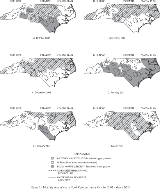
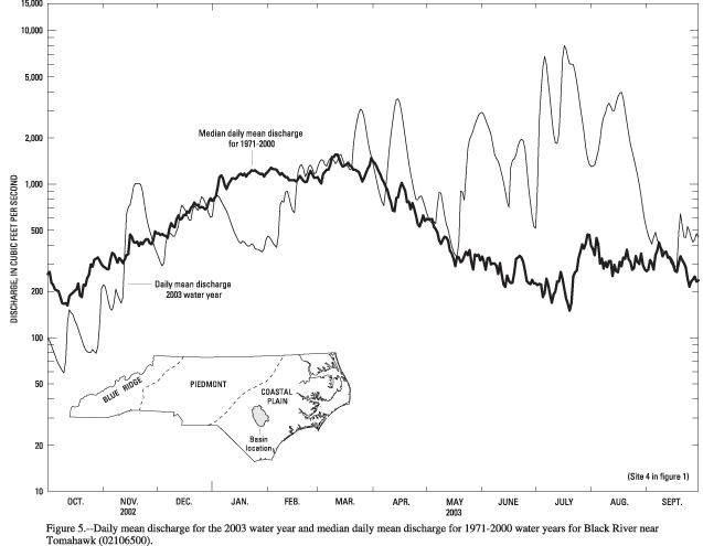
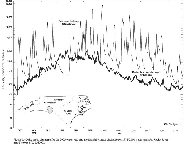
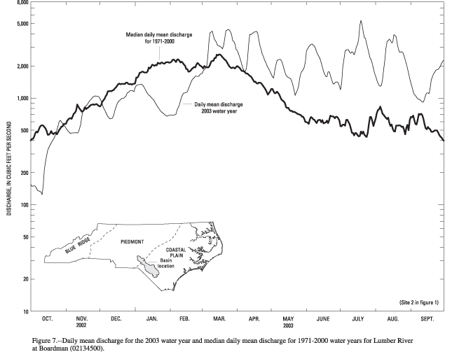
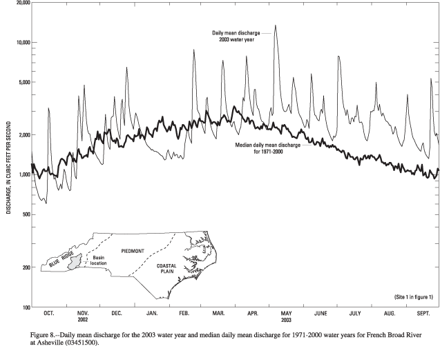
Streamflow conditions in North Carolina are influenced greatly by precipitation. Precipitation can produce rapid responses in streamflow. Streamflow also declines following periods of low precipitation. The rate and magnitude of decline depend on basin size, the season, evapotranspiration, and the amount of ground water in storage at the onset of the dry period. The effects of variable precipitation on streamflow in North Carolina during the 2003 water year are illustrated in figures 3-8 (fig 3 GIF/PDF, fig 4 GIF/PDF, fig 5 GIF/PDF, fig 6 GIF/PDF, fig 7 GIF/PDF, fig 8 GIF/PDF). Monthly conditions are depicted in maps (figs. 3 GIF/PDF and 4 GIF/PDF) that show the areas of above-normal, normal, and below-normal streamflow. Daily mean streamflow hydrographs for a representative basin in each physiographic province of the State are shown in figures 5-8 (fig 5 GIF/PDF, fig 6 GIF/PDF, fig 7 GIF/PDF, fig 8 GIF/PDF).
Data for the period of record from 35 index streamgaging stations across the State were used to compute monthly flow statistics (figs. 3 GIF/PDF and 4 GIF/PDF). These stations are located on streams that are free of significant regulations or diversions and range in size from about 30 to 1,400 square miles. The descriptors, "above normal," "normal," and "below normal," refer to flow in the upper quartile, the middle two quartiles, and the lower quartile, respectively.
Despite above-normal precipitation at most of the six precipitation index sites during the first six months (October through March) of the 2003 water year (fig. 3 GIF/PDF); only 42 percent of the 35 index streamgaging stations experienced above normal streamflow, 48 percent were normal, and 10 percent had below-normal conditions. During the period from April through September, the soils became more saturated from sustained, above-normal precipitation across the State. As a result, 87 percent of the index sites had above-normal streamflow, and 13 percent had normal streamflow conditions. No sites had below-normal conditions during this period (fig. 4 GIF/PDF). The excess precipitation eased the hydrologic drought conditions that were persistent across much of North Carolina during the previous 4 years. Many streamgages, particularly those in the Piedmont and Coastal Plain, recorded the highest annual mean streamflow for the period of record. While individual period-of-record peak streamflows were not prevalent, the total amount of water flowing past 13 of 35 streamgages was greater than had previously been recorded at these sites.
Near the close of the 2003 water year, on September 18, Hurricane Isabel made landfall as a category-2 hurricane near Drum Inlet, North Carolina. Isabel brought tropical-storm conditions to a large area of eastern North Carolina and produced storm surges of 6-8 ft above normal tide levels near the point of landfall along the Atlantic coast of North Carolina and 4-6 ft above normal tide levels over the eastern portions of the Pamlico Sound and most of the Albemarle Sound. Precipitation from Hurricane Isabel averaged 4-7 inches across large portions of eastern North Carolina.
![]()
Return to WY 2003 Annual Data Report Home Page
![]()