U.S. Geological Survey Karst Interest Group Proceedings, Shepherdstown, West Virginia, August 20-22, 2002POSTER SESSION ABSTRACTSUse of Dye Tracing To Determine Conduit Flow Paths Within Source-Protection Areas of a Karst Spring and Wells in the Bear River Range, Northern UtahBy Lawrence E. Spangler
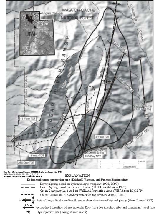
AbstractDrinking-water source-protection areas for wells and springs in fractured-rock terranes are often delineated by using analytical models and time-of-travel methods based on Darcian concepts. These methods, however, generally assume that the aquifers in these terranes behave as uniform, porous media at the scale of the study area. Source-protection areas and time-of-travel zones delineated for Dewitt Spring and two wells discharging from carbonate rocks in the Bear River Range in northern Utah were compared to results of dye tracing. Results of five tracer tests indicate that time of travel based on porous-media concepts can be substantially overestimated in hydrogeologic terranes where conduit flow paths are present. Ground-water travel times of less than 8 days and average velocities of as much as 2,000 feet per day were documented within the delineated areas. Source-protection areas in these terranes also may be under or over estimated when surface-water divides are assumed to be ground-water divides. As a result, dye tracing can be used to help delineate areas that do not contribute to springs or wells, and thus, minimize the area that is necessary for source-protection management. INTRODUCTIONThe U.S. Environmental Protection Agency (EPA) established guidelines for the delineation of wellhead-protection areas in unconfined, porous, granular aquifers such as unconsolidated sand and gravel (U.S. Environmental Protection Agency, 1987). Methods for delineating wellhead-protection areas in these types of hydrogeologic settings generally assume porous-media (Darcian) flow and are not intended to be applicable in ground-water systems in which water movement is mostly along fractures. Subsequently, the Wisconsin Geological and Natural History Survey (1991), in conjunction with the EPA, produced a document concerning the delineation of wellhead-protection areas in fractured rocks. Although the study sites included a carbonate (dolomite) aquifer, it was assumed that the flow systems functioned similar to those in a uniform, porous medium at the scale of the study area. Eckenfelder, Inc. (1996), again in conjunction with the EPA, produced a definitive document detailing guidelines for delineation of wellhead- and springhead-protection areas in carbonate terranes, where nonporous-media flow predominates. Drinking-water source-protection areas for wells in fractured-rock terranes are often delineated by using analytical models and time-of-travel methods based on Darcy flow equations. Aquifers in these terranes, however, generally are assumed to behave as uniform, porous media at the scale of the study area. Fractured-rock aquifers that do not behave as porous media, such as those in carbonate (karst) terranes, generally cannot be studied with the same methods used to characterize porous-media aquifers. In these hydrogeologic settings, delineation of source-protection areas or zones of contribution for wells and particularly springs, often can be done only by integration of hydrogeologic mapping techniques such as water-level measurements, estimates of ground-water basin size by comparison of normalized base flow of springs (discharge balancing), and dye-tracer tests (Eckenfelder, Inc., 1996). In addition, analysis of water chemistry can provide useful information with regard to sources of water and potential flow paths (Jensen and others, 1997). Dye tracing used in conjunction with water-table contour maps derived from water-level measurements have proven to be the most effective methods for determining zones of contribution (recharge areas), general directions of ground-water flow, and residence times for water in fractured-rock aquifers that are characterized by nonporous-media flow (Mull and others, 1988). Carbonate AquifersMost aquifers in carbonate rocks (limestone and dolomite) consist of integrated components of both diffuse and conduit flow (Shuster and White, 1971 and table 1). Consequently, these aquifers are typically dual or triple porosity and include both discrete fracture as well as conduit (solutionally-enlarged fracture) flow paths. Diffuse-flow components may function very similar to porous-media flow on a regional scale, with ground-water movement typically along poorly integrated fractures and other pathways where movement is comparatively slow. Conduit-flow (karst) components are character-ized by solutional enlargement of fractures and bedding-plane partings, promoting rapid ground-water movement along complex pathways. As a result, porous-media concepts (Darcian flow) generally do not apply. Carbonate-rock aquifers generally are highly anisotropic, and hydraulic-conductivity values can range over several orders of magnitude (table 1). Thus, ground-water velocities and travel times can vary considerably. In addition, travel times typically decrease with increases in discharge. Although average values for hydraulic properties determined from well tests may be representative of carbonate aquifers on a regional scale, solutional enlargement of fractures and bedding-plane partings typically results in preferred pathways with increased ground-water velocity that need to be considered when source-protection areas are delineated. Delineation of Source-Protection AreasDewitt Spring near Logan, Utah (fig. 1), provides an example of the use of dye tracing to determine conduit flow paths and recharge areas in comparison to source-protection areas delineated by methods based largely on porous-media (Darcian) concepts. Dewitt Spring discharges from Paleozoic-age carbonate (limestone and dolomite) rocks to the Logan River, which is base level for ground water that discharges from this alpine region. Discharge from the spring ranges from a low flow of about 10 cubic feet per second during the winter to a peak flow of as much as 35 cubic feet per second in late spring during snowmelt runoff (Dennis Corbridge, City of Logan, written commun., 1998). Dewitt Spring discharges along the axis of a regional syncline where the Logan River breaches the structure. On the basis of discharge variation, structural geology, and dye-tracing studies, ground-water flow to the spring is probably down dip to the axis of the syncline, along solutionally-enlarged bedding planes and fractures. The source-protection area for Dewitt Spring was delineated by using hydrogeologic mapping methods, including stratigraphic relations and structural geology (Eckoff, Watson, and Preator Engineering, 1996). Time-of-travel zones determined from calculated average linear velocity and representing 250-day and 3-year ground-water travel times were established within the delineated area (State of Utah, 1995 and fig. 1). Time-of-travel distance to the spring within these zones was determined to be about 2,300 and 10,200 feet, respectively, based on an average linear velocity of about 9.3 feet per day. Beyond the 3-year time-of-travel boundary and within the area delineated by hydrogeologic mapping, ground-water travel times were assumed to be as long as 15 years. Because time-of-travel methods are not applicable in this hydrogeologic setting, the source-protection area for Dewitt Spring was subsequently revised (1997) and all of the zones were combined into one zone delineated on the basis of hydrogeologic mapping (fig. 1). Subsequent dye tracing to the spring indicates flow paths with considerably faster travel times than those determined by time-of-travel calculations. Maximum ground-water travel times ranging from 22 to almost 31 days were determined for losing stream reaches 3.0 to 7.2 miles upgradient from Dewitt Spring (table 2) and within the delineated source-protection area (fig. 1). These travel times also indicate that minimum average ground-water velocities ranged from about 530 to 1,740 feet per day (table 2). Because passive (cumulative adsorption) dye-tracing methods were used, however, ground-water travel times are probably substantially shorter and velocities are greater.
Table 2. Summary of dye traces to Dewitt Spring, Logan Canyon, northern Utah [ft/d, feet per day; ft3/s, cubic feet per second] Maximum travel time: Travel time calculated from initial dye
recovery on activated charcoal; actual travel time probably substantially less.
Dye tracing in the mapped zone of contribution for these wells indicates that ground water flows, in part, to the southeast away from the wells, and discharges at Dewitt Spring, in the adjacent surface-water basin (fig. 1). Results of dye tracing also show that a large part of the source-protection area delineated for the Green Canyon wells probably lies within the recharge area for Dewitt Spring. Maximum travel time of ground water to the spring from the Green Canyon area during base flow was less than 8 days, with a minimum average velocity of almost 2,000 feet per day (table 2). CONCLUSIONSDye tracing shows that time of travel based on porous-media (Darcian) concepts can be substantially overestimated in hydrogeologic settings where conduit flow paths are present. Although slower components of flow along diffuse pathways are present within the recharge (contributing) areas of the springs and wells and may simulate porous-media flow on a regional scale, recognition of conduit pathways is crucial in predicting the transport and fate of contaminants to public-water supplies developed in these settings. Further, source-protection areas for springs and wells in these terranes may be under or over estimated when ground- and surface-water divides are assumed to be the same. As a result, dye tracing can be used to help delineate areas that do not contribute to springs or wells, and thus, minimize the area that is necessary for source-protection management. REFERENCESBlandford, T.N., and Huyakorn, P.S. 1991, WHPA 2.0: A Modular Semi-Analytical Model for the Delineation of Wellhead Protection Areas: U.S. Environmental Protection Agency, Office of Ground-Water Protection, Washington, D.C. Dover, J.H., 1987, Geologic map of the Mount Naomi Roadless Area, Cache County, Utah, and Franklin County, Idaho: U.S. Geological Survey Miscellaneous Field Studies Map MF-1566-B, scale 1:100000. Eckenfelder, Inc., 1996, Guidelines for wellhead and springhead protection area delineation in carbonate rocks: U.S. Environmental Protection Agency, Groundwater Protection Branch, Region 4, Atlanta, Georgia, 127 p., 1 pl. Eckoff, Watson, and Preator Engineering (consulting firm), 1996; revised 1997, Drinking water source protection plan for Dewitt Spring, city of Logan, Utah; prepared for the city of Logan and submitted to the Utah Department of Environmental Quality, Division of Drinking Water, Salt Lake City, Utah. Eckoff, Watson, and Preator Engineering (consulting firm), 1999; revised 2000, Drinking water source protection plan for Green Canyon wells no. 1 and 2, city of North Logan, Utah; prepared for the city of North Logan and submitted to the Utah Department of Environmental Quality, Division of Drinking Water, Salt Lake City, Utah. Jensen, M.E., Lowe, M., and Wireman, M., 1997, Investigation of hydrogeologic mapping to delineate protection zones around springs; report of two case studies: National Risk Management Research Laboratory, U.S. Environmental Protection Agency Technical Report 600/R-97/023, 60 p. Mull, D.S., Smoot, J.L., and Liebermann, T.D., 1988, Dye tracing techniques used to determine ground-water flow in a carbonate aquifer system near Elizabethtown, Kentucky: U.S. Geological Survey Water-Resources Investigations Report 87-4174, 95 p. Natural Resources Conservation Service, 2002, Federal standards for delineation of hydrologic unit boundaries, version 1.0. Shuster, E.T., and White, W.B., 1971, Seasonal fluctuations in the chemistry of limestone springs; a possible means for characterizing carbonate aquifers: Journal of Hydrology, v. 14, p. 93-128. State of Utah, Department of Environmental Quality, Division of Drinking Water, 1995, Drinking water source protection rule, R309-113, 17 p. U.S. Environmental Protection Agency, 1987, Guidelines for delineation of wellhead protection areas: Office of Ground-Water Protection, Washington, D.C., 186 p. Wisconsin Geological and Natural History Survey, 1991, Delineation of wellhead protection areas in fractured rocks: U.S. Environmental Protection Agency, Ground-Water Protection Division, Office of Groundwater and Drinking Water, Washington, D.C., 144 p. U.S.Geological Survey Karst Interest Group Proceedings,Shepherdstown,West Virginia, August 20-22, 2002, Water-Resources Investigations Report 02-4174 The use of firm, trade, and brand names in this report is for identification purposes only and does not consitute endorsement by the U.S. Government.
|
||||||||||||||||||||||||||||||||||||||||||||||||||||||||||||||||||||||||||||||||||||||||||||||||||||||||||||||||||||||||||||||||||||||||||||||||||||||||||||||||||||||||||||||||||||||||

![]() U.S. Department of the Interior |
U.S. Geological Survey
U.S. Department of the Interior |
U.S. Geological Survey
URL: http://pubsdata.usgs.gov/pubs/wri/2002/4174/les_tracing.html
Page Contact Information: GS Pubs Web Contact
Page Last Modified: Friday, 25-Oct-2024 11:26:50 EDT