|
|
|
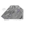
Description of Study AreaThe headwaters of Daisy Creek originate in the Custer National Forest and the New World Mining District in south-central Montana at an altitude of about 9,400 ft. Daisy Creek is about 2.2 mi long and flows northwest into the Stillwater River at an altitude of 8,500 ft about 1 mi downstream from the river’s headwaters. Daisy Creek can be divided into three reaches on the basis of topography and hydrology. The upstream reach, from 0 to 1,340 ft, (cover photograph) is in the bottom of a glacial cirque. The stream valley is relatively flat, and considerable ground water discharges to Daisy Creek. The streambed is composed of sand and small cobbles. In many places, the streambed is cemented with iron oxyhydroxide, forming ferricrete. One unusual feature in this reach is a manganese bog, formed where acidic ground water discharges, on the north side of Daisy Creek (fig. 2). Vegetation in this bog is coated with black manganese precipitates. The middle reach, from 1,340 to 9,925 ft, (fig. 3) is steeper than the upper and lower reaches and is incised in a narrow ravine within the broader valley. The streambed within this cascading reach is composed mostly of bedrock and large boulders. The downstream reach, from 9,925 to 11,549 ft, (fig. 4) has a lower gradient than the middle reach. The channel has a typical pool-and-riffle sequence, and the streambed is composed of cobbles. The Stillwater River downstream from Daisy Creek is similar in character to the lower reach of Daisy Creek, except that the channel is larger owing to the greater streamflow.
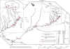
Water quality and biota in Daisy Creek have been affected adversely by acid rock drainage (Gurreri, 1998). Metal concentrations, which have been measured since the mid-1970s in Daisy Creek downstream from the McLaren Mine, ranged from 930 to 7,360 μg/L dissolved copper and 130 to 1,200 μg/L dissolved zinc in 1989-96; pH values ranged from 3.1 to 5.0 (URS Operating Services, Inc., 1998). Metals transported from Daisy Creek affect the Stillwater River for several miles downstream. In this reach of the Stillwater River, concentrations of total-recoverable copper are near the chronic aquatic-life standard established by the U.S. Environmental Protection Agency (U.S. Environmental Protection Agency, 1999), and copper concentrations in bed sediment are elevated at least 10-fold over background values for streams in nearby unmineralized basins (Gurrieri, 1998). Fish and other aquatic life typical of most mountain streams are absent from Daisy Creek owing to the acidic and metal-rich nature of the stream. In the Stillwater River downstream from Daisy Creek, biointegrity decreases sharply from levels in the river upstream of Daisy Creek; macroinvertebrate and periphyton communities are impoverished and dominated by metal-tolerant species (Gurrieri, 1998). The New World Mining District is underlain by lower Paleozoic sedimentary rocks that were subjected to Tertiary igneous activity, alteration, and mineralization. The sedimentary rocks include the Cambrian Flathead Sandstone, Wolsey Shale, Meagher Limestone, Park Shale, Pilgrim Limestone, and Snowy Range Formation, and the Ordovician Bighorn Dolomite. Tertiary igneous activity included brecciation and intrusion of stocks, laccoliths, sills, and dikes. Alteration and mineralization in the mining district were associated with this intrusive activity. The economic deposits contain gold, copper, and silver and are either skarn and replacement deposits hosted mainly by the Meagher Limestone, replacement and vein deposits along high-angle faults, or replacement deposits in limestone blocks within intrusion breccias. The ore bodies and surrounding altered rock are rich in sulfide minerals, including pyrite and chalcopyrite (Elliot, 1979; Elliot and others, 1992). Erosion by the glacial ice cap that covered the Beartooth Plateau during the late Pleistocene exposed unweathered pyritic rocks in the New World Mining District. Oxidation of these pyritic rocks released acid and metals to surface and ground water. Ferricrete deposits in the three stream valleys draining the mining district document the existence of this natural acid rock drainage. Radiocarbon age dates for wood embedded in five ferricrete samples collected from the Daisy Creek drainage were more than 300 years old, predating mining; four of five samples were more than 6,400 years old (Furniss and others, 1999). Mining for gold, copper, and silver began in 1869 in the New World Mining District (Elliot and others, 1992). The principal mining-related feature in the Daisy Creek drainage is the McLaren Mine on the southern flank of Fisher Mountain (fig. 2). Several prospects are located in the drainage on the north side of Crown Butte. The McLaren Mine is an open-pit mine that was active from 1933 to 1953 (Elliot and others, 1992). The McLaren deposit was the most extensively mined ore body in the district. Several short adits were driven into Fisher Mountain, but most were later exhumed by the open pit mine. Only the upper portion of the McLaren deposit was mined. In 1987, Crown Butte Mines, Inc., began exploratory drilling and estimated that over two million tons of sulfide-rich ore remained in the McLaren deposit. In 1993, after deciding not to proceed with mining, the company began surface-restoration work to reclaim the historical open pit. The pit was recontoured to approximate pre-mining topography, and diversion ditches were constructed to prevent ponding of water and to reduce the amount of water that infiltrated through the pit and associated waste rock. Revegetation efforts in 1994 included liming, seeding, and fertilization (URS Operating Services, Inc., 1998). Drainage from the McLaren Mine area flows to Daisy Creek through surface and subsurface (ground-water) pathways. Many small intermittent streams convey surface runoff from the mine area to Daisy Creek. In late summer, most of these streams are dry except near their confluence with Daisy Creek. The lower reaches of these streams are perennial, with surface flow derived from ground-water discharge. Whether the surficial layer of glacial deposits or the underlying bedrock is the primary conduit for this subsurface flow is not known. In either circumstance, drainage from the McLaren Mine area is acidic and metal rich. Potential sources of the metals and acidity include the mineralized rocks of Fisher Mountain upgradient of the McLaren Mine area, the surficial waste rock at the mine, or the underlying bedrock, which hosts both the McLaren deposit and surrounding altered rock that is pyritic. Average annual precipitation in the study area is about 60 in. The mean annual snowpack is between 300 and 500 in., with the thickest snowpack occurring in May. Peak streamflow occurs during snowmelt runoff in June and July. Base-flow conditions are approached in late summer and continue through the winter (URS Operating Services, Inc., 1998). |
Home page for USGS Water Resources Investigations Report 00-4261
| AccessibilityFOIAPrivacyPolicies and Notices | |
 |
|