
The removal of the remnants of three hydroelectric dams on the Kalamazoo River near Plainwell, Otsego, and Allegan, Michigan, has been proposed. The benefits of this removal include returning the Kalamazoo River to its pre-dam flow, increasing recreational use and safety on the river, and improving aquatic habitat. The U.S. Environmental Protection Agency has designated this reach of the Kalamazoo River as a Federal Superfund site because of the historical discharge of papermill waste containing polychlorinated biphenyls. Much of this waste material remains concentrated in organic sediment and kaolinite clay deposited upstream from the three dam foundations. Sediment containing up to 150 milligrams per kilogram polychlorinated biphenyls could move if dam foundations are removed; therefore, it is necessary to estimate the characteristic and configuration of the sediment before work begins.
Data collected from augered sections and sediment cores show that impoundment sediments were deposited in two distinctly different sedimentary environments. Interbedded lacustrine sediments that overlie the pre-dam channel surface consist of organic-rich silt and clay, fine to medium sand, and some gravel. These materials were deposited in a repetitive, cyclic fashion related to former stream velocities when the impoundment water levels were 5-10 feet higher. Lowering of these water levels and demolition of the superstructures of these dams resulted in erosion of much of these instream lacustrine sediments and subsequent deposition of coarse-grained alluvium in the impounded channel behind the remaining dam foundations.
The composite thicknesses of the lacustrine deposits and overlying alluvium was determined from sediment cores collected from each impoundment. The volume of instream sediment contained in each impoundment is estimated to be about 77,600 cubic yards at the Plainwell impoundment; 268,900 cubic yards at the Otsego impoundment; and 1,192,600 cubic yards at the Trowbridge impoundment. Estimates do not include bank or flood-plain deposits.
A series of hydroelectric dams was constructed from 1899 to 1904 on the Kalamazoo River between the cities of Plainwell and Allegan, Michigan (fig. 1). Three of these dams (Plainwell, Otsego, and Trowbridge) were decommissioned as power generators in the mid-1960s. By 1970, ownership had been transferred from Consumers Power Company to the Michigan Department of the Natural Resources (MDNR). During this period, water levels behind these dams were lowered, exposing previously inundated sediments (Camp Dresser & McKee, 1999a, 1999b, 2000). The superstructures, consisting of powerhouses, gates, upper abutment walls, and some of the spillway, were removed in 1985-86. Sediment containing polychlorinated biphenyl (PCB) continued to be transported and deposited downstream from each dam foundation as new channels cut through the previously impounded areas. In 2001, Camp Dresser & McKee, Inc., stabilized the remaining spillway abutment walls and aprons of the Plainwell, Otsego, and Trowbridge dam foundations (Todd King, Camp Dresser & McKee, oral commun., 2001).
The MDNR is considering the option of removing dam foundations. Removal of the structures will return part of the Kalamazoo River to run-of-river flow, will increase recreational uses and safety on the river, and will improve aquatic habitat in affected river sections. The removal of any dam, however, may result in some problems. The two most common problems encountered are the movement of sediment downstream and the upstream migration of invasive species from the Great Lakes to the headwater areas. Because additional impoundments downstream of the project area will remain in place, migration of invasive species should not be a problem; however, movement of sediments is a concern.
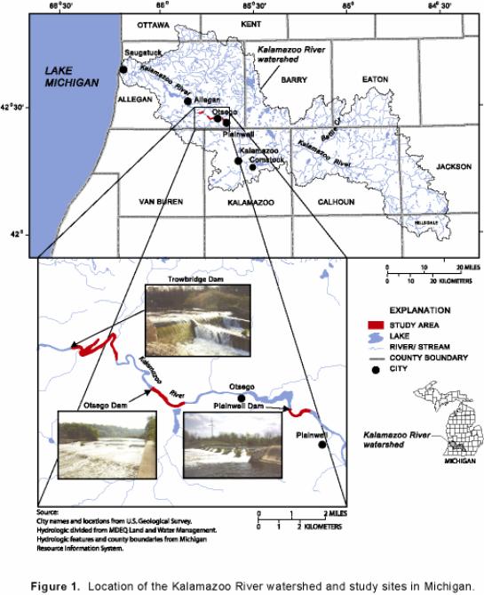
Figure 1. Location of the Kalamazoo River watershed and study sites in Michigan.
The USEPA has designated the Kalamazoo River from the city of Kalamazoo to its outlet into Lake Michigan as a Federal Superfund site, owing to contamination with PCBs. According to Camp Dresser & McKee (1999c), the primary industrial activity associated with PCB releases to the Kalamazoo River was the recycling at various area papermills of carbonless copy paper containing PCBs as an ink solvent. Kalamazoo-area papermills that de-inked or re-pulped the PCB-containing carbonless copy paper from 1957 to 1971 incorporated PCBs in their waste discharge. The paper wastes also included kaolinite clays, which concentrate PCBs (as much as 150 milligrams per kilogram PCB in the impoundments; Blasland, Bouck, & Lee, 1994). Much of this waste clay remains impounded behind the three dam foundations. If the dam foundations are removed, transport and deposition of the impounded materials could alter the downstream characteristics of the stream channel and increase PCB exposure potential to stream biota.
In summer 2000, the USGS, in cooperation with MDEQ, studied the volume, character, and size distribution of instream sediments in three of the impoundments on the Kalamazoo River and determined the configuration of the present-day and pre-dam stream channels.
This report (1) describes the results of the USGS-MDEQ data-collection effort in the three Kalamazoo River impoundments, (2) relates this information to the depositional history of sediments deposited behind the dams, and (3) provides estimates of the volume of instream sediment upstream of three dam foundations. Maps of sediment location and thickness, as well as tables of lithology and particle-size distribution are provided.
The authors thank Todd King (Camp Dresser & McKee, Inc., Detroit, Mich.), Dennis Eagle (Michigan Department of Environmental Quality-Environmental Response Division, Lansing, Mich.), and Brian Mailot (USGS, Columbus, Ohio) for technical support. Technical reviewers were Faith A. Fitzpatrick (USGS, Middleton, Wis.), Michael J. Sweat (USGS, Lansing, Mich.), and Paul Bucholtz, (Michigan Department of Environmental Quality-Environmental Response Division, Lansing, Mich.). Editorial and graphic support were provided by Michael Eberle and Leah Hout (USGS, Columbus, Ohio) and Sharon B. Baltusis (USGS, Lansing, Mich.).
The cities of Plainwell, Otsego, and Allegan lie in the Kalamazoo River Valley in southwestern Michigan (fig. 1). This river valley was a large glacial meltwater channel, formed in the interlobate zone between the Michigan and Saginaw glacial-ice lobes during the late Pleistocene Epoch (Leverett and Taylor, 1915). Broken upland ridges (consisting of poorly bedded cobbley sand and gravel) formed as the Michigan Ice Lobe retreated to the west (Monaghan and Larson, 1984). These ridges mark the drainageways or channels of a much larger river that flowed during this glacial epoch (Deutsch and others, 1960). As ice blocks melted and outlets lowered, the Kalamazoo River assumed its modern-day size and course (Martin, 1958).
Presently (2002), the main stem of the Kalamazoo River originates in Calhoun County at the confluence of the North and South Branches and flows northwestward for 123 mi to Lake Michigan near the city of Saugatuck. The river has meandering channels and point bars, and flows through a broad, well-defined floodplain. The Kalamazoo River has a drainage area of more than 2,000 mi2 with more than 400 mi of tributaries, including Portage Creek, a known source of PCBs (Stratus Consulting, Inc., 2000). A USGS streamflow-gaging station has been operated on the Kalamazoo River at Comstock, Mich. in Kalamazoo County from 1931 to the present. The drainage area at Comstock is 1,010 mi2. The mean annual flow for the 69-year period of record is 893 ft3/s. A maximum daily mean flow of 6,830 ft3/s was recorded on April 8, 1947, and a minimum daily mean flow of 185 ft3/s was recorded on August 7, 1934 (Blumer and others, 2000). In general, the Kalamazoo River has a low gradient (less than 5 ft/mi). Where gradients are higher, the river historically has been impounded for hydroelectrical and other industrial purposes (Blasland, Bouck & Lee, Inc., 1994).
This study was conducted to determine the volume, character, and size distribution of sediments in the three impoundments and to delineate the configuration of the present-day and pre-dam stream channels. Hand augering along transect lines was done to determine sediment thickness. Cores of streambed sediments were collected and sieved to determine grain-size of the material.
Selection of transects and data points
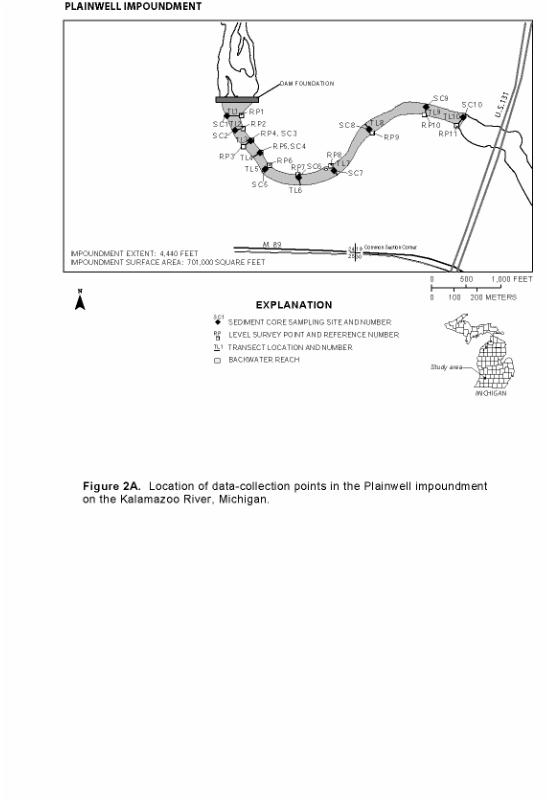
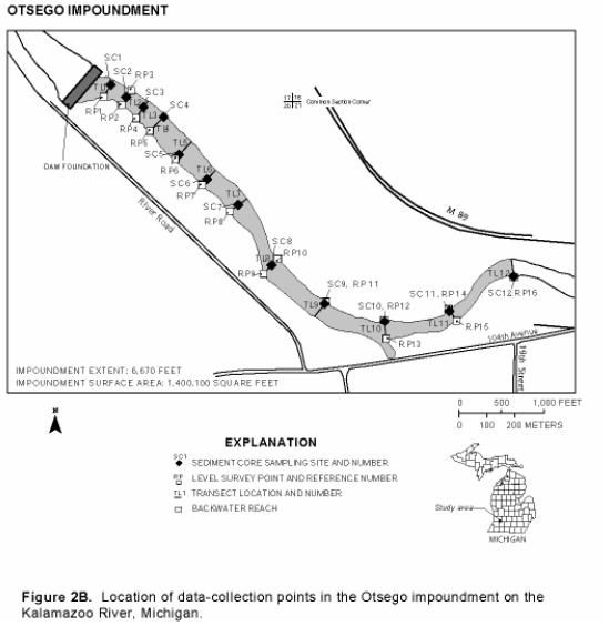
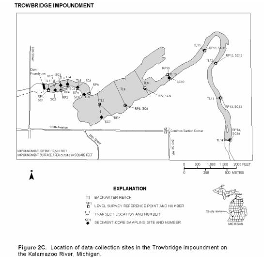
Transect spacing was based on the river width at each of the respective dam foundations (figs. 2A-2B-2C). Transect 1 in each impoundment was as close to the dam as safety would allow. Transects 2, 3, and 4 were spaced upstream at intervals of one river width apart. Transects 5, 6, and 7 were spaced at intervals of two river widths apart. Transects 8 and higher were spaced at four river widths apart until the end of backwater was reached for each impoundment. Backwater behind each dam foundation extends upstream approximately 4,440 ft at the Plainwell impoundment, 6,670 ft at the Otsego impoundment, and 12,500 ft at the Trowbridge impoundment. The end of backwater typically was indicated by increased river velocities, riffles, and debris islands. From 10 to 14 transects were established in each impoundment. This spacing was chosen in order to provide useful information for planned development of a one-dimensional open channel mixed-size sediment transport model (Bennett, 2001).
Reference points were established at each transect by driving a steel fencepost into the right or left bank, close to the waters edge. Altitudes of the top of the reference points were surveyed to 0.1 ft by Camp Dresser & McKee in fall 2000. Altitudes of bank height and water surface were measured down from reference points as transects were completed. An outside staff gage at each impoundment was used to account for daily water-surface fluctuations during water-depth measurements.
A 3/16-inch steel cable tagline, painted at 5-ft intervals, was stretched across the river perpendicular to the channel at each transect. Global Positioning System (GPS) coordinates were taken at both ends of the tagline. The channel width was divided into 15 equal sections for the measurement of water depth, velocity, and sediment thickness (appendix A, tables A1-A2-A3). A GPS coordinate was taken at each measuring point. Water depth and velocity were measured by standard USGS methods (Rantz and others, 1982) using a boat-cable measuring device equipped with an A-reel, a 15- or 30-lb weight, and a Price AA standard current meter.
Collection of data points and sediment cores
Data points (water depth, velocity, and sediment thickness) and a sediment core were collected across each transect in the three impoundments (figs. 2A-2B-2C). Thickness of the post-dam sediment was obtained by boring with a 1-ft-long by 11/2 in.-diameter auger bit with 4-ft extension pipes. The depth of the post-dam sediment that overlay the pre-dam alluvium (altitude prior to dam construction) was indicated when the auger no longer could be advanced and a grinding sound could be heard from contact of the auger bit with cobbles and stones. Transect core samples generally were collected where impoundment sediments were thickest by driving a 10-ft length of 11/4 in.-diameter polyvinyl chloride tube into the sediments until refusal. Changes in sediment texture and color were observed in the field, and representative samples were collected from the core where lithology changed. Lithologic descriptions of the cores are summarized in tables B1-B2-B3 (appendix B). A total of 82 samples from 36 cores were collected and sieved at the Michigan State University Soil Science Laboratory using U.S. Standards Sieves (appendix C, tables C1-C2-C3).
Water depth and bottom of the post-dam sediment were hand contoured to 1-ft intervals by use of auger-point and sediment-core data. These contours were used to generate a GIS grid surface, which was compared to field measurements. This comparison allowed for a root mean squared error of depth to be calculated for each data point. Areas with error values greater than 1 ft were recontoured and the grid was regenerated. Once all grid surfaces had error values less than 1 ft, the thickness of the post-dam sediment was mapped by subtracting the depth of water grid from the depth of the post-dam sediment grid.
The total estimated volume of the impoundment sediment (in cubic yards) was calculated by taking the sum of the products of the area of each cell multiplied by its thickness. Areas between transects were digitized, and the number of square feet within each area was computed. These measured areas were used in conjunction with sediment thickness per digitized area to compute volume of sediments between transects.
SEDIMENT CHARACTERISTICS WITHIN THE IMPOUNDMENTS
Stratigraphic relations among the sediments within and flanking the channel vary as a function of distance upstream from each dam. The impoundment area for each dam can be divided into two distinctive zones: an upper zone and a lower zone.
Upper zones are areas flooded by the dams when their superstructures were intact and the dams were fully operational at design pool levels (5-10 ft higher than at present). As water levels behind the dams were lowered, previously inundated sediment was exposed. In areas near the dam foundations, lacustrine deposits (as much as 4 ft thick) can be seen along the banks, flood plains, and wetlands. In the upstream reaches of the historical impoundments, lacustrine deposits remain in the flood plain but have been eroded completely in the present-day river channel. At these locations, increased slopes and river velocities have exposed very coarse pre-dam alluvium, which in some places has been overlain by post-superstructure sand and gravel.
Lower zones are areas flooded by the remaining dam foundations and are the focus of this study. Three distinct stratigraphic units can be identified in the lower zone. These units are (1) outwash and alluvial cobble, gravel, and sand, deposited before dam construction, (2) interbedded lacustrine clay, silt, and sand, deposited during routine dam operation, and (3) sand and gravel deposited since the superstructure was dismantled.
As glacial ice retreated from the study area, meltwaters flowed westward through continually lowering outlets. The glacial Kalamazoo River was much larger than the present river, eroding large volumes of sediment as it cut through outwash and lake plains to form the Kalamazoo River Valley. After the end of the Pleistocene epoch, the volume of water discharged through the Kalamazoo River diminished greatly, leaving the river to occupy only a small part of its outwash- and alluvium-filled ancestral river valley (Deutsch and others, 1960). For thousands of years, the Kalamazoo River meandered across the Kalamazoo River Valley, reworking the pre-dam outwash and alluvium. This pre-dam material is identified easily and consists of cobbles, coarse gravel, and lesser amounts of medium to coarse sand.
Construction of the three dams raised water levels approximately 5-10 ft higher than the present dam foundations. Lacustrine material deposited in the impoundments consisted of interbedded, organic-rich silt and clay, fine to medium sand, and some gravel. Coarse-grained layers were deposited cyclically in response to floods. Based on current streambank elevations, the thickness of these dam lacustrine deposits ranged from 0 to 12 ft at the Plainwell impoundment, from 0 to 12 ft at the Otsego impoundment, and from 0 to 16 ft at the Trowbridge impoundment.
After the dam superstructures were removed and water levels lowered, new channels were cut through the dam lacustrine deposits. Auger data points and sediment cores collected in the summer of 2000 showed that the thickness of the eroded, instream lacustrine deposits now ranges from 0 to 9.7 ft at the Plainwell impoundment (table 1A), from 0 to 8.5 ft at the Otsego impoundment (table 1B), and from 0 to 13.1 ft at the Trowbridge impoundment (table 1C).
After the channels stabilized, sand and gravel began to aggrade within the impoundments. These post-superstructure alluvial deposits lie directly over the remaining post-dam lacustrine deposits. The thickness of the post-superstructure alluvium ranges from 0 to 1.5 ft at the Plainwell impoundment (table 1A), from 1 to 5.5 ft at the Otsego impoundment (table 1B), and from 0 to 7.5 ft at the Trowbridge impoundment (table 1C).
Table 1. Characteristics of stream bottom and sediments at sediment-core sites in three impoundments on the Kalamazoo River, Michigan
[Altitude in feet above sea level; no., number; ft, feet]
Table 1. Characteristics of stream bottom and sediments at sediment-core sites in three impoundments on the Kalamazoo River, Michigan -- Continued
SEDIMENT CONFIGURATION WITHIN THE IMPOUNDMENTS
Impoundment bathymetry and delineation of pre-dam river channel
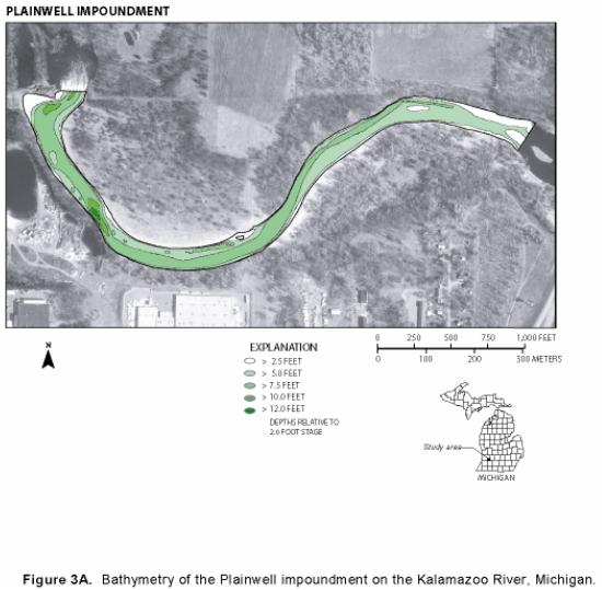
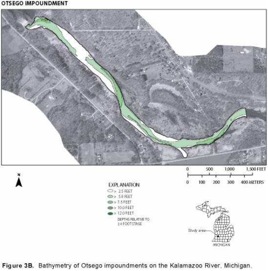
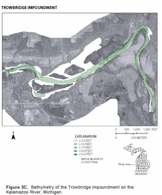
Altitude of the water surface, streambed, and base of the impoundment sediment was determined at each data-collection point along transect lines. Altitudes for each layer were established by mean of stadia level and rod survey (appendix A, tables A1-A2-A3). Water depths in the impoundments during low flows ranged from 0 to12 ft, average depths being less than 5 ft (figs. 3A-3B-3C).
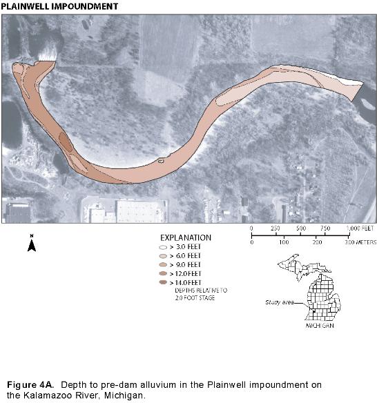
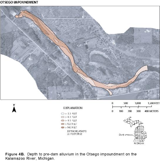
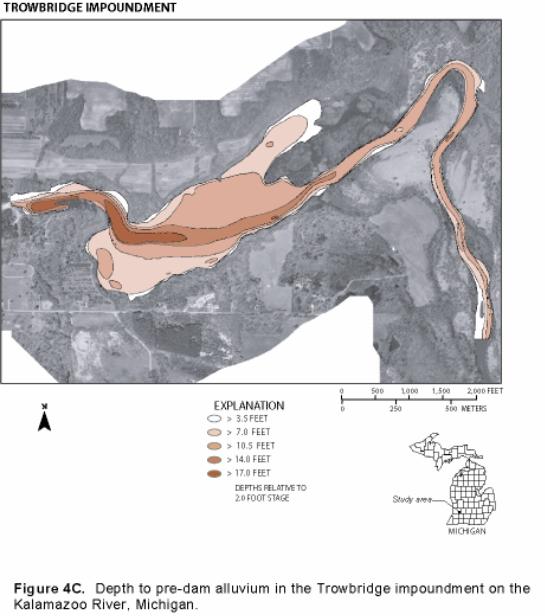
As inferred from sediment-thickness data gathered near the dam foundations, the bottom of the pre-dam river was at altitudes 4-7 ft lower than bottom of the current impoundment (figs. 4A-4B-4C). Lower altitudes at the dam foundations would result in slopes of more than 2 percent, so the post-dam Kalamazoo River would be classified as a moderate-gradient river with riffle-dominated channels and infrequently spaced pools (Rosgen, 1994). Particle sizes of core samples collected in the three impoundments indicate that the pre-dam river consisted of a cobble-gravel bottom and very stable cobble- and boulder-lined banks.
The extent and thickness of the sediment deposited behind the dams at higher water levels (sediment now within the flood plain) were not mapped in this study; however, while mapping the sediment thickness of the current river channels, the study team saw distinctive pre-dam channels (figs. 4A-4B-4C). The maps of depth to pre-dam alluvium indicate that the pre-dam channel meandered across the current lacustrine flood plain and that these maps could be used as a starting point for mapping the course of pre-dam river channels.
Sediment thickness and volume in the impoundments
When water levels were lowered and superstructures were removed, dam lacustrine deposits were eroded, transported, and redistributed. New channels were formed, and increased river velocities began to transport and deposit coarser grained sands and gravel into the impoundments. These post-superstructure alluvium deposits are not PCB free because PCBs continue to be released into the channel from erosion of flood-plain deposits, slumping streambanks, and channel-bed scour (Camp Dresser & McKee, 1999c). Field notes from summer of 2000 describe the coarse-grained post-superstructure alluvium as gray or dirty sands, indicating that some silt/clay/organic material is present and that traces of PCBs are also likely present.
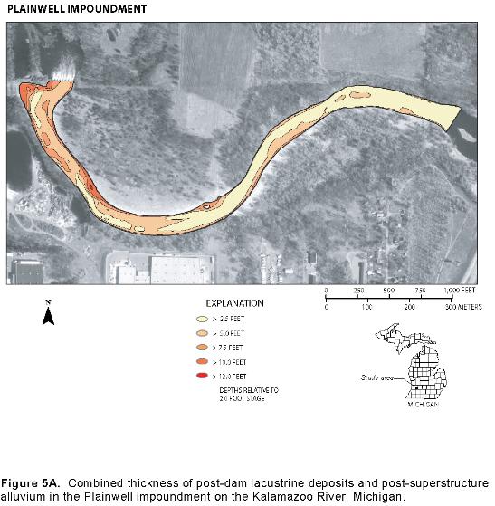
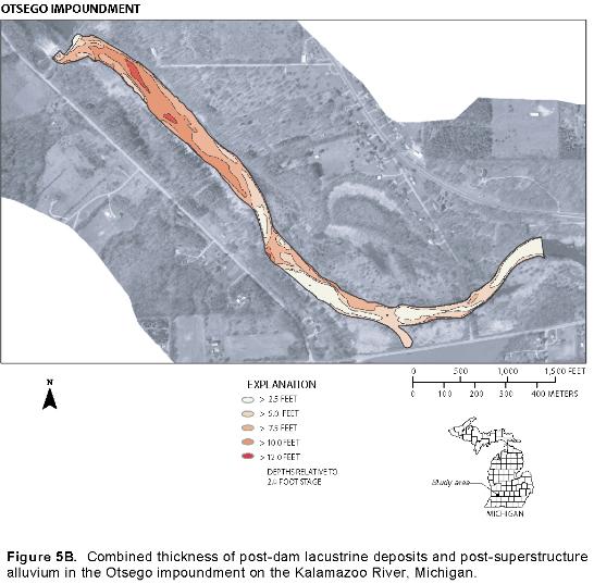
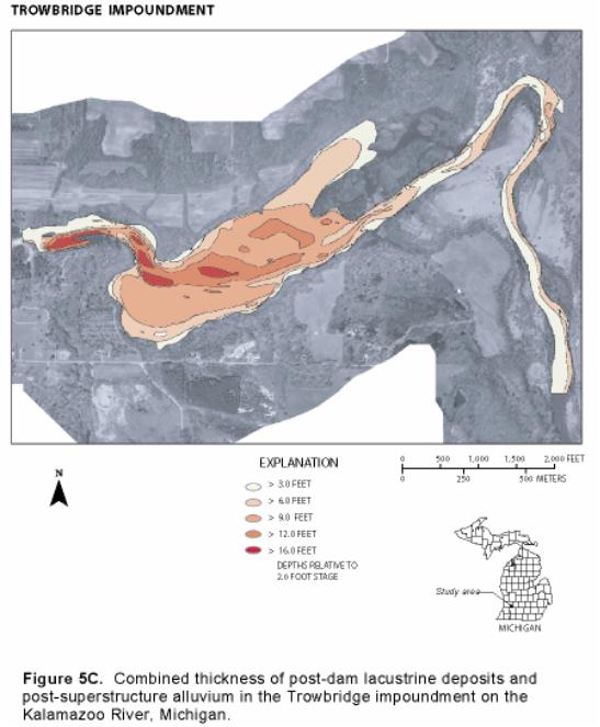
Post-superstructure alluvium and dam lacustrine deposits in the channel are both capable of being transported downstream if the dam foundations are removed (Westjohn, 1997). For this reason, the post-superstructure alluvium and dam lacustrine deposits are considered as one unit and reported as cubic yards of instream sediment for each impoundment (figs. 5A-5B-5C). The total volume of instream sediment in the three impoundments is greater than (>) 1,500,000 yd3, most of the sediment (> 75 percent) being in the Trowbridge impoundment. The estimated volumes of impoundment sediments and their corresponding sediment-thickness errors are summarized in table 2.
Upstream from the Plainwell dam foundation, the total instream-sediment volume is estimated to be 77,600 yd3. Sediment thickness ranges from 0 to 10.9 ft, and average thickness is 3.0 ft over the 701,000-ft2 area (tables 3A-3B-3C). Approximately 60 percent of the sediment is between the dam and transect 6, in the lower one-third of the impoundment (figs. 2A and 5A).
Upstream from the Otsego dam foundation, the total instream-sediment volume is estimated to be 268,900 yd3. Sediment thickness ranges from 0 to 14.0 ft, and average thickness is 5.7 ft over the 1,400,100-ft2 area. Approximately 66 percent of the sediment is between transects 4 and 10, in the middle one-third of the impoundment (figs. 2B & 5B).
Upstream from the Trowbridge dam foundation, the total instream-sediment volume is estimated to be 1,192,600 yd3. Sediment thickness ranges from 0 to 16.5 ft, and average thickness is 4.9 ft over the 5,724,900-ft2 area. Approximately 80 percent of the sediment is between transects 6 and 10, in the middle of the impoundment (figs. 2C and 5C).
Figure 3A. Bathymetry of the Plainwell impoundment on the Kalamazoo River, Michigan.
Figure 3B. Bathymetry of Otsego impoundments on the Kalamazoo River, Michigan.
Figure 3C. Bathymetry of the Trowbridge impoundments on the Kalamazoo River, Michigan.
Figure 4A. Depth to pre-dam alluvium in the Plainwell impoundment on the Kalamazoo River, Michigan.
Figure 4B. Depth to pre-dam alluvium in the Otsego impoundment on the Kalamazoo River, Michigan.
Figure 4C. Depth to pre-dam alluvium in the Trowbridge impoundment on the Kalamazoo River, Michigan.
Table 2. Estimates of the instream-sediment volume and root mean squared (RMS) error of sediment thickness in three impoundments on the Kalamazoo River, Michigan
[yd3, cubic yards; ft, feet]
| Impoundment |
Estimated instream- sediment volume (yd3)
|
Average RMS error of sediment thickness (ft)
|
|---|---|---|
| Plainwell |
77,600
|
0.65
|
| Otsego |
268,900
|
0.9
|
| Trowbridge |
1,192,600
|
0.72
|
Table 3. Volume of sediment between transects in three impoundments on the Kalamazoo River, Michigan
[ft, foot; ft2, square foot; yd3, cubic yard; transects shown in figs. 2A-2B-2C]
Table 3. Volume of sediment between transects in three impoundments on the Kalamazoo River, Michigan--Continued
[ft, foot; ft2, square foot; yd3, cubic yard; transects shown in figs. 2A-2B-2C
Three hydroelectric dams were constructed from 1899 to 1904 on the Kalamazoo River between the cities of Plainwell and Allegan, Michigan. The superstructures, consisting of powerhouses, gates, upper abutment walls, and some of the spillway, were removed in 1985-86. The MDNR is considering the option of removing the remaining dam foundations. Removal of the structures will return part of the Kalamazoo River to run-of-river flow, increase recreational uses and safety on the river, and improve aquatic habitat in affected river sections. However, the USEPA has designated the Kalamazoo River from the city of Kalamazoo to its outlet into Lake Michigan as a Federal Superfund site, owing to PCB contamination in the sediment. Much of this contaminated sediment remains impounded behind the three dam foundations. If the dam foundations are removed, transport and deposition of the impounded materials could alter the downstream characteristics of the stream channel and increase PCB exposure potential to stream biota.
In summer 2000, the USGS, in cooperation with MDEQ, studied the volume, character, and size distribution of instream sediments in three of the impoundments on the Kalamazoo River and determined the configuration of the present-day and pre-dam stream channels. Sediment cores were collected at 36 sites from three dam impoundments on the Kalamazoo River, near Plainwell, Otsego, and Allegan, Michigan. Sediment-depth profiles and particle-size analysis of core samples formed the principal basis for an interpretation of the sedimentation history and lithology at each dam. Approximately 15 data points along transect lines were used to develop sediment-depth profiles of the pre- and post-dam streambeds.
- The pre-dam streambed has been reasonably well defined upstream from each dam foundation. The pre-dam streambed is composed of very coarse outwash and alluvium material, is easily identifiable, and consists of cobbles, coarse gravel, and lesser amounts of medium to coarse sand. All of the sediment-depth data points for this study terminated in this coarse pre-dam outwash and alluvium.
- Two distinct types of deposits are present upstream from the dam foundations: (1) lacustrine deposits that accumulated after dams were constructed and before superstructures were removed and (2) alluvial deposits that accumulated on the erosional surface cut into the lacustrine deposits after removal of the dam superstructures.
- Dam lacustrine deposits consist of interbedded, organic-rich silt and clay, fine to medium sand, and some gravel. Based on current streambank elevations, the thickness of these post-dam lacustrine deposits ranged from 0 to 12 ft at the Plainwell impoundment, from 0 to 12 ft at the Otsego impoundment, and from 0 to 16 ft at the Trowbridge impoundment.
- Post-superstructure alluvium deposits are mostly sand and gravel with traces of silt and clay. This coarse-grained surface is related to increases in gradient and velocity that took place after water levels were lowered and dam superstructures removed. These alluvium deposits lie directly upon remaining instream lacustrine deposits. Thickness of the post-superstructure alluvium ranges from 0 to 1.5 ft at the Plainwell impoundment, from 1 to 5.5 ft at the Otsego impoundment, and from 0 to 7.5 ft at the Trowbridge impoundment.
- In the Plainwell impoundment, sediment volume (the combined volumes of post-dam lacustrine deposits and post-superstructure alluvium) is estimated to be 77,600 yd3. Sediment thickness ranges from 0 to 10.9 ft, and average thickness is 3.0 ft over an area of 701,000 ft2. Approximately 60 percent of the sediment is between the dam foundation and transect 6, in the lower third of the impoundment.
- In the Otsego impoundment, sediment volume is estimated to be 268,900 yd3. Sediment thickness ranges from 0 to 14.0 ft, and average thickness is 5.7 ft over an area of 1,400,100 ft2. Approximately 66 percent of the sediment is between transects 4 and 10, in the middle third of the impoundment.
- In the Trowbridge impoundment, sediment volume is estimated to be 1,192,600 yd3. Sediment thickness ranges from 0 to 16.5 ft, and average thickness is 4.9 ft over an area of 5,724,900 ft2. Approximately 80 percent of the sediment is between transects 6 and 10, in the middle of the impoundment.
- Present-day stream gradients in the impoundments are low (less than 2 percent). Sediment-thickness data gathered in the impoundments indicate that pre-dam river-bottom depths near the dam foundations were at altitudes 4-7 ft lower than the present-day river bottom. Removal of dam foundations and corresponding sediment would increase the river slope to more than 2 percent, so the Kalamazoo River would be classified as a moderate-gradient system with riffle-dominated channels and infrequently spaced pools.
