|
|
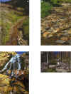
Description of Study AreaThe headwaters of Miller Creek originate in the Gallatin National Forest in south-central Montana (fig. 1). Miller Creek flows southeast from Bull of the Woods Pass (altitude about 9,700 ft) to Soda Butte Creek (altitude about 7,600 ft) just east of the town of Cooke City (fig. 2) and about 3.5 mi east of Yellowstone National Park. One small, unnamed tributary, commonly called and hereinafter referred to as the East Fork Miller Creek, drains the area below Daisy Pass (altitude about 9,700 ft). The Miller Creek channel upstream from the East Fork, commonly called the West Fork (Maxim Technologies, Inc., 1995), is referred to as the mainstem of Miller Creek in this report. The confluence of the East Fork Miller Creek is about 0.6 mi downstream from the origin of Miller Creek (fig. 2).The streambed varies throughout the study reach (fig. 3). In the upper reach (from about site 0 to site 3,225), the streambed is composed of mostly gravel and cobbles. Near mid-basin (downstream from site 3,225 to about site 7,120), the Miller Creek streambed is mostly composed of large cobbles with some scattered boulders. In the lower reach (between sites 7,120 and site 14,505), the stream is mostly confined to a steep, narrow incised channel, and flow is mostly over exposed bedrock. Streamflow near the downstream end of the lower reach cascades through a series of small waterfalls. At the downstream end of the study reach, the channel once again becomes less constricted and the streambed is composed of cobbles, boulders, and woody debris (fig. 3). Many of the boulders found in the streambed probably represent a lag deposit from the erosion of glacial till on the valley floor.
Mining for gold began in 1870 in the Miller Creek watershed (Lovering, 1929). Adits, trenches, tailings piles, waste-rock dumps, and prospect pits are scattered throughout the watershed. Most of these mining features are relatively small but larger mines include the Daisy, Little Daisy, Black Warrior, and the Alice E. Mines. The Black Warrior Mine is the only mine that is close to the Miller Creek channel. Several other small waste-rock piles and prospect pits also are located along the creek. The Daisy, Little Daisy, and Alice E. Mines are uphill from Miller Creek, on the south slope of Henderson Mountain. Paleozoic sedimentary rocks intruded by Tertiary igneous rocks and subjected to genetically related alteration and mineralization underlie the New World Mining District. The sedimentary rocks include the Cambrian Flathead Sandstone, Wolsey Shale, Meagher Limestone, Park Shale, Pilgrim Limestone, and Snowy Range Formation, and the Ordovician Bighorn Dolomite. Tertiary igneous activity included hydrothermal brecciation and intrusion of stocks, laccoliths, sills, and dikes. Alteration and mineralization in the mining district were associated with this intrusive activity. The larger, recently discovered mineral deposits are gold, copper, and silver-bearing skarn and replacement deposits hosted mainly by the Meagher Limestone, replacement deposits in limestone along high- angle faults, and replacement deposits hosted in limestone blocks within intrusion breccias. The Little Daisy Mine is located in an area of this latter style of mineralization, with mineralized blocks of Pilgrim Limestone within an intrusion breccia (Elliott and others, 1992). The Black Warrior Mine is located in an area of vein and replacement mineralization developed in the Ordovician Bighorn Dolomite along a high-angle fault or fracture structure. The Black Warrior Mine contains lead and zinc mineralization typical of vein-type mineralization in the perimeter of the district where lower temperature hydrothermal fluids were telescoped out along faults and fractures (Allan R. Kirk, Maxim Technologies, Inc., Helena, Mont., written commun, 2001). The Alice E. Mine complex is a small open-pit mine that recovered gold from stockwork fracture- controlled gold-pyrite mineralization in the Cambrian Flathead Sandstone. The intrusive complexes, ore bodies, and surrounding altered rocks are all rich in sulfide minerals, including pyrite and chalcopyrite (Elliott, 1979; Elliott and others, 1992). Natural (non-mining related) acid drainage is evidenced by the presence of several ferricrete deposits in the Miller Creek watershed. Radiocarbon dating of wood embedded in one ferricrete deposit in the Miller Creek watershed resulted in an age estimate of more than 2,000 years old. This age estimate clearly predates mining and substantiates a natural source of acid drainage (Furniss and others, 1999). Three main faults traverse the upper reaches of the Miller Creek watershed (fig. 2). The eastern fault trends north towards the Little Daisy adit, the middle fault correlates with the regionally extensive north-south trending Crown Butte fault, and the western fault extends into the Daisy Creek watershed (Elliot, 1979; Maxim Technologies, Inc., 1995). Each of these faults are splays of the Crown Butte Fault. The eastern and middle faults converge in the upper portion of the East Fork Miller Creek. The western fault parallels the upper portion of Miller Creek. |
|
Home page for USGS Water Resources Investigations Report 02-4148
|