|
WRIR 99-4079: Estimates of Ground-Water Discharge as Determined from Measurements of Evapotranspiration, Ash Meadows Area, Nye County, Nevada |
|
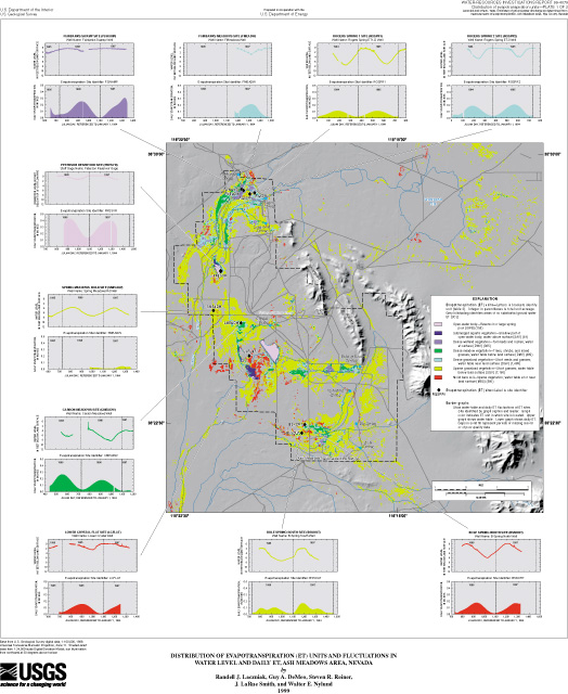
Table 7. Estimated annual evapotranspiration (ET) at ET sites in Ash Meadows area, Nevada
| Site name | Site identifier (pl. 1) |
ET-unit identifier 1 |
Period of record 2 | Estimated annual ET (feet) |
|||
|---|---|---|---|---|---|---|---|
| Processed 3 | Computed 4 | ||||||
| Start | End | Start | End | ||||
| Bole Spring North | BSNORT | MBS | 731 | 1320 | 744 | 1109 | 2.60 |
| Bole Spring South | BSSOUT | SGV | 731 | 1461 | 731 | 1461 | 1.88 |
| Carson Meadow | CMEADW | DMV | 446 | 1176 | 446 | 1176 | 3.44 |
| Fairbanks Meadow | FMEADW | DGV | 1168 | 1475 | 1168 | 1475 | 3.735 |
| Fairbanks Swamp | FSWAMP | DWV | 651 | 1340 | 761 | 1126 | 3.91 |
| Lower Crystal Flat | LCFLAT | MBS | 699 | 1251 | 725 | 1090 | 2.58 |
| Peterson Reservoir | PRESVR | OWB | 869 | 1336 | 907 | 1272 | 8.60 |
| Rogers Spring 1 | RGSPR1 | SGV | 1 | 730 | 1 | 730 | 1.92 |
| Rogers Spring 2 | RGSPR2 | DGV | 1 | 730 | 1 | 730 | 3.23 |
| Spring Meadow | SMEADW | SGV | 979 | 1346 | 979 | 1344 | 0.62 |
1 ET units are described in table 3.
2 Period of record is defined by starting and ending day. Days are referenced to January
1, 1994.
3 Period of record processed to calculate daily ET shown in figure 13 and on plate 1.
4 Period of record used to estimate annual ET.
5 Annual ET rate estimated from less than 1 year of data.