
Table 8. Calibration results for the seven-parameter log-linear regression model of nutrient and sediment concentrations for selected sites in the lower Tennessee River Basin
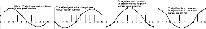
[The numerical values of the coefficients β1-β6 are not shown; rather, the table entries indicate the time period spanned by the calibration data sets, which varied among sites and constituents; the colors of the numbers indicate the statistical significance and the sign (positive or negative) of the regression coefficients β1-β6 (see eq. 1); 1985-95, coefficient significant and positive; 1985-95, coefficient significant and negative; 1985-95, coefficient not significant; β1 significant and positive (negative) indicates that concentrations increase (decrease) with increasing streamflow; β3 significant and positive (negative) indicates an increasing (decreasing) temporal trend in concentration; β5 and β6 significant indicate that concentrations vary in a seasonal pattern, the patterns are illustrated at the bottom of the table; additional interpretation of the significance and sign of each coefficient is explained in the text; other regression statistics, such as coefficient of determination and standard error, are reported with load estimates in table 9; --, not estimated, and results not shown on fig. 19 because record during common period was insufficient; entries in italics are subject to larger error than the other entries, for various reasons (described in footnotes); R (riverine), tributary site at which streamflow is not regulated, or at which a major component of streamflow is not regulated; FR (flow regulated), site located in an impoundment or where streamflow is strongly influenced by an upstream impoundment; common period, the time span of the calibration data set used to obtain trend estimates for this common period is indicated in the table entries]
_____________________________________________________________________________________________________________________________________________
                                                                                                                                     Common
                                                                                                                                     period
  Site 					                                     β1		                   β5             β6	      β3
 identi-  Surface-water station/site location			         (Logarithm	    β3           (Sine	       (Cosine	    ________
fication  _________________________________________________    Site	     of	         (Decimal        {2 * π        {2 * π      (Decimal
(fig. 2)  Number	       Name		               type	 streamflow)	   time)	 * time})      * time})	     time)
_____________________________________________________________________________________________________________________________________________

Total nitrogen as N

  1	PR1038	    Clarks River at Almo, Ky.	                R	  1985-95	  1985-95        1985-95       1985-95	    1985-94

  2	03604000    Buffalo River near Flat Woods, Tenn.	R	  1982-95	  1982-95	 1982-95       1982-95	    1985-94

  4	001025	    Duck River below Normandy Dam, Tenn.	FR	  1986-95	  1986-95	 1986-95       1986-95	    --

  5	001065	    Duck River at Williamsport, Tenn.	        R	  1982-94	  1982-94	 1982-94       1982-94	    1982-94

  6	475793	    Duck River above Hurricane Mills, Tenn.	R	  1986-93	  1986-93	 1986-93       1986-93	    1985-94

  7	002395	    Shoal Creek at Highway 43 near 	        R	  1983-92	  1983-92	 1983-92       1983-92	    --
                      Lawrenceburg, Tenn. a

  9	001207	    Elk River below Tims Ford Dam, Tenn.	FR	  1984-94	  1984-94	 1984-94       1984-94	    1985-94

 10	475796	    Elk River near Prospect, Tenn.	        R	  1987-92	  1987-92        1987-92       1987-92	    --

 11	FLCR7	    Flint Creek near Falkville, Ala.	        R	  1993-97	  1993-97	 1993-97       1993-97	    --

 12	TOWNCREEK15 Town Creek near Geraldine, Ala.	        R	  1988-96	  1988-96	 1988-96       1988-96	    --

 13	002375	    Sequatchie River at Valley Road, Tenn. a	R	  1983-95	  1983-95	 1983-95       1983-95	    1985-94

 14	03609750    Tennessee River at Highway 60 near          FR	  1980-84	  1980-84	 1980-84       1980-84	    --
                      Paducah, Ky.

 15	202832	    Tennessee River at mile 23, Ky. b	        FR	  1990-94	  1990-94	 1990-94       1990-94	    --

 16	03593005    Tennessee River at Pickwick Landing Dam, 	FR	  1980-96	  1980-96	 1980-96       1980-96	    1985-94
                      Tenn.

 17	03571850    Tennessee River at South Pittsburg, Tenn.	FR	  1980-85	  1980-85	 1980-85       1980-85	    --

 18	003315	    Tennessee River below Raccoon Mountain,     FR	  1981-94	  1981-94	 1981-94       1981-94	    1985-94
                      Tenn.

Total ammonia as N

  1	PRI038	    Clarks River at Almo, Ky.	                R	  1985-95	  1985-95	 1985-95       1985-95	    1986-94

  2	03604000    Buffalo River near Flat Woods, Tenn.	R	  1987-92	  1987-92	 1987-92       1987-92	    --

  4	001025	    Duck River below Normandy Dam, Tenn.	FR	  1987-95	  1987-95	 1987-95       1987-95	    --

  5	001065	    Duck River at Williamsport, Tenn.	        R	  1984-94	  1984-94	 1984-94       1984-94	    1986-94

  6	475793	    Duck River above Hurricane Mills, Tenn.	R	  1987-94	  1987-94	 1987-94       1987-94	    --

  7	002395	    Shoal Creek at Highway 43 	                R	  1984-94	  1984-94	 1984-94       1984-94	    1986-94
                      near Lawrenceburg, Tenn. a

  9	001207	    Elk River below Tims Ford Dam, Tenn.	FR	  1984-94	  1984-94	 1984-94       1984-94	    1986-94

 10	475796	    Elk River near Prospect, Tenn.	        R	  1987-94	  1987-94	 1987-94       1987-94	    --

 11	FLCR7	    Flint Creek near Falkville, Ala.	        R	  1993-97	  1993-97	 1993-97       1993-97	    --

 12	TOWNCREEK15 Town Creek near Geraldine, Ala. c	        R	  1988-96	  1988-96	 1988-96       1988-96	    --

 13	002375	    Sequatchie River at Valley Road, Tenn. a	R	  1983-95	  1983-95	 1983-95       1983-95	    1986-94

 15	202832	    Tennessee River at mile 23, Ky. b	        FR	  1990-94	  1990-94	 1990-94       1990-94	    --

 16	03593005    Tennessee River at Pickwick Landing Dam,    FR	  1980-96	  1980-96	 1980-96       1980-96	    --
                      Tenn.

 17	03571850    Tennessee River at South Pittsburg, Tenn.	FR	  1980-86	  1980-86	 1980-86       1980-86	    --

 19	SCARHAM-    Scarham Creek near Kilpatrick, Ala.	        R	  1988-96	  1988-96	 1988-96       1988-96	    --
        CREEK03

Total ammonia plus organic nitrogen as N

  1	PRI038	    Clarks River at Almo, Ky.	                R	  1985-95	  1985-95	 1985-95       1985-95	    1986-93

  2	03604000    Buffalo River near Flat Woods, Tenn.	R	  1982-95	  1982-95	 1982-95       1982-95	    1986-93

  4	001025	    Duck River below Normandy Dam, Tenn.	FR	  1986-95	  1986-95	 1986-95       1986-95	    --

  5	001065	    Duck River at Williamsport, Tenn.	        R	  1981-92	  1981-92	 1981-92       1981-92	    1986-93

  6	475793	    Duck River above Hurricane Mills, Tenn.	R	  1986-93	  1986-93	 1986-93       1986-93	    1986-93

  7	002395	    Shoal Creek at Highway 43, 	                R	  1983-94	  1983-94	 1983-94       1983-94	    1986-93
                      near Lawrenceburg, Tenn. a

  9	001207	    Elk River below Tims Ford Dam, Tenn.	FR	  1984-94	  1984-94	 1984-94       1984-94	    1986-93

 10	475796	    Elk River near Prospect, Tenn.	        R 	  1986-93	  1986-93	 1986-93       1986-93	    1986-93

 11	FLCR7	    Flint Creek near Falkville, Ala.	        R	  1993-97	  1993-97	 1993-97       1993-97	    --

 12	TOWNCREEK15 Town Creek near Geraldine, Ala.	        R 	  1988-96	  1988-96	 1988-96       1988-96	    --

 13	002375	    Sequatchie River at Valley Road, Tenn. a	R	  1983-95	  1983-95 	 1983-95       1983-95	    1986-93

 14	03609750    Tennessee River at Highway 60 near 	        FR	  1980-84	  1980-84	 1980-84       1980-84	    --
                      Paducah, Ky.

 15	202832	    Tennessee River at mile 23, Ky. b	        FR	  1990-94	  1990-94	 1990-94       1990-94	    --

 16	03593005    Tennessee River at Pickwick Landing Dam,	FR	  1986-93	  1986-93	 1986-93       1986-93	    1986-93
                      Tenn.

 17	03571850    Tennessee River at South Pittsburg, Tenn.	FR	  1980-85	  1980-85	 1980-85       1980-85	    --

 18	003315	    Tennessee River below Raccoon Mountain,	FR	  1981-94	  1981-94	 1981-94       1981-94	    1986-93
                      Tenn.

 19	SCARHAM-    Scarham Creek near Kilpatrick, Ala.	        R	  1988-96	  1988-96	 1988-96       1988-96	    --
        CREEK03

Total nitrite plus nitrate as N

  1	PRI038	    Clarks River at Almo, Ky.	                R	  1985-95	  1985-95	 1985-95       1985-95	    1985-94

  2	03604000    Buffalo River near Flat Woods, Tenn.	R	  1986-93	  1986-93	 1986-93       1986-93	    1985-94

  4	001025	    Duck River below Normandy Dam, Tenn.	FR	  1987-95	  1987-95	 1987-95       1987-95	    --

  5	001065	    Duck River at Williamsport, Tenn.	        R	  1982-93	  1982-93	 1982-93       1982-93	    --

  6	475793	    Duck River above Hurricane Mills, Tenn.	R	  1987-93	  1987-93	 1987-93       1987-93	    --

  7	002395	    Shoal Creek at Highway 43, Tenn. a	        R	  1983-94	  1983-94	 1983-94       1983-94	    1985-94

  9	001207	    Elk River below Tims Ford Dam	        FR	  1984-94	  1984-94	 1984-94       1984-94	    1985-94

 10	475796	    Elk River near Prospect, Tenn.	        R	  1987-93	  1987-93	 1987-93       1987-93	    --

 11	FLCR7	    Flint Creek near Falkville, Ala.	        R	  1993-97	  1993-97	 1993-97       1993-97	    --

 12	TOWNCREEK15 Town Creek near Geraldine, Ala.	        R	  1988-96	  1988-96	 1988-96       1988-96	    --

 13	002375	    Sequatchie River at Valley Road, Tenn. a	R	  1983-95	  1983-95	 1983-95       1983-95	    1985-94

 14	03609750    Tennessee River at Highway 60 near          FR	  1980-84	  1980-84	 1980-84       1980-84	    --
                      Paducah, Ky.

 15	202832	    Tennessee River at mile 23, Ky. b	        FR	  1990-94	  1990-94	 1990-94       1990-94	    --

 16	03593005    Tennessee River at Pickwick Landing Dam,	FR	  1980-96	  1980-96	 1980-96       1980-96	    1985-94
                      Tenn.

 17	03571850    Tennessee River at South Pittsburg, Tenn.	FR	  1980-85	  1980-85	 1980-85       1980-85	    --

 18	003315	    Tennessee River below Raccoon Mountain,     FR	  1981-94	  1981-94	 1981-94       1981-94	    1985-94
                      Tenn.

 19	SCARHAM-    Scarham Creek near Kilpatrick, Ala.	        R	  1988-96	  1988-96	 1988-96       1988-96	    --
        CREEK03

 20	SOUTH-	    South Sauty Creek, Ala.	                R	  1988-96	  1988-96	 1988-96       1988-96	    --
        SAUTYCK03

Total phosphorus as P

  1	PRI038	    Clarks River at Almo, Ky.	                R	  1985-95	  1985-95	 1985-95       1985-95	    1985-93

  2	03604000    Buffalo River near Flat Woods, Tenn.	R	  1983-95	  1983-95	 1983-95       1983-95	    1985-93

  4	001025	    Duck River below Normandy Dam, Tenn.	FR	  1987-94	  1987-94	 1987-94       1987-94	    --

  5	001065	    Duck River at Williamsport, Tenn.	        R	  1981-93	  1981-93	 1981-93       1981-93	    1985-93

  6	475793	    Duck River above Hurricane Mills, Tenn.	R	  1988-93	  1988-93	 1988-93       1988-93	    --

  7	002395	    Shoal Creek at Highway 43 near	        R	  1983-94	  1983-94	 1983-94       1983-94	    1985-93
                      Lawrenceburg, Tenn. a

  9	001207	    Elk River below Tims Ford Dam, Tenn.	FR	  1983-94	  1983-94	 1983-94       1983-94	    1985-93

 10	475796	    Elk River near Prospect, Tenn.	        R	  1986-94	  1986-94	 1986-94       1986-94	    --

 14	03609750    Tennessee River at Highway 60 near 	        FR	  1980-84	  1980-84	 1980-84       1980-84	    --
                      Paducah, Ky.

 15	202832	    Tennessee River at mile 23, Ky. b	        FR	  1990-94	  1990-94	 1990-94       1990-94	    --

 16	03593005    Tennessee River at Pickwick Landing Dam,	FR	  1980-93	  1980-93	 1980-93       1980-93	    1985-93
                      Tenn.

 17	03571850    Tennessee River at South Pittsburg, Tenn.	FR	  1980-86	  1980-86	 1980-86       1980-86	    --

Dissolved orthophosphorus as P

  2	03604000    Buffalo River near Flat Woods, Tenn.	R	  1984-95	  1984-95	 1984-95       1984-95	    --

  6	475793	    Duck River above Hurricane Mills, Tenn.	R	  1986-91	  1986-91	 1986-91       1986-91	    --

 10	475796	    Elk River near Prospect, Tenn.	        R	  1987-91	  1987-91	 1987-91       1987-91	    --

 11	FLCR7	    Flint Creek near Falkville, Ala. c	        R	  1993-97	  1993-97	 1993-97       1993-97	    --

 12	TOWNCREEK15 Town Creek near Geraldine, Ala. c	        R	  1988-96	  1988-96	 1988-96       1988-96	    --

 16	03593005    Tennessee River at Pickwick Landing Dam, 	FR	  1983-93	  1983-93	 1983-93       1983-93	    --
                      Tenn.

 15	202832	    Tennessee River at mile 23, Ky. b	        FR	  1990-94	  1990-94	 1990-94       1990-94	    --

 19	SCARHAM-    Scarham Creek near Kilpatrick, Ala.	        R	  1988-96	  1988-96	 1988-96       1988-96	    --
        CREEK03

Suspended sediment

  2	03604000    Buffalo River near Flat Woods, Tenn.        R	  1982-95	  1982-95	 1982-95       1982-95	    --

  3	03596000    Duck River below Manchester, Tenn. d	R	  1979-83	  1979-83	 1979-83       1979-83	    --

  8	03588500    Shoal Creek at Iron City, Tenn. d	        R	  1979-83	  1979-83	 1979-83       1979-83	    --

 16	03593005    Tennessee River at Pickwick Landing Dam,	FR	  1980-93	  1980-93	 1980-93       1980-93	    --
                      Tenn.

 17	03571850    Tennessee River at South Pittsburg, Tenn.	FR	  1980-86	  1980-86	 1980-86       1980-86	    --
_____________________________________________________________________________________________________________________________________________

a Regression results are subject to error because streamflow-measurement and water-quality-sampling sites were not colocated.
b Regression results are subject to error due to grab sampling methods at this vertically stratified site.
c Regression results are subject to error due to variable minimum reporting level and large percentage of observations below minimum reporting level.
d The calibration data set included data from 1979 in order to have sufficient length of record.
Seasonal patterns: Printable version of this figure also available as a PDF
| Title Page | Table of Contents | List of Illustrations | List of Tables | Conversion Factors and Vertical Datum | Glossary |