The Yellowstone River Basin (YRB) is one of more than 50 study units in the U.S. Geological Survey (USGS) National Water-Quality Assessment (NAWQA) program. Gilliom and others (1995, p. 2) describe the framework for NAWQA, including selection of diverse river basins that drain about one-half of the conterminous United States and reflect 60-70 percent of the national water use and population. The program is designed to describe the status and trends in the quality of the Nation's surface and ground water, and link assessment of the status and trends with an understanding of the natural and human factors that affect water quality.
The NAWQA study units were divided into three groups on a rotational schedule, with one group of studies beginning in 1991, a second set in 1994, and the third in 1997. The YRB NAWQA study began in 1997, during the third round of study-unit start-ups (Miller and Quinn, 1997). The cycle for each study unit consists of 2 years of initial planning and retrospective analysis, 3 years of intensive data collection and analysis, and 6 years of report preparation and low-level assessment activity. This report has been prepared as part of the retrospective analysis of existing data for the YRB investigation.
The NAWQA program assesses water quality of streams based on three interrelated components: water column, bed sediment and fish tissue, and ecological studies (Gilliom and others, 1995, p. 9). Analysis of the existing data for elements in bed sediment of the study unit will aid in sampling design and interpretation of the bed-sediment data to be collected by the YRB NAWQA investigation. As part of the overall YRB NAWQA retrospective effort, State, Federal, and local agencies were surveyed for water-quality data sets, including bed-sediment analyses.
The National Uranium Resource Evaluation (NURE) Program collected the only bed-sediment data set with virtually complete coverage for the study unit. The NURE program was initiated by the Atomic Energy Commission in 1973 as a nationwide, systematic study of uranium resources. The program, which later came under the auspices of the U.S. Department of Energy, had nine components, including the Hydrogeochemical and Stream Sediment Reconnaissance (HSSR) (Information Systems Programs, Energy Resources Institute, 1985), the data from which are used in this report.
Sources of bed-sediment data, other than HSSR, include the USGS National Water Information System (NWIS) data base and site-specific investigations such as Chaffee and others (1997) and studies associated with the Cooke City Environmental Impact Statement (U.S. Department of the Interior and U.S. Department of Agriculture, 1997). Data from site-specific investigations generally were not included in this report because of concerns about comparing data collected and analyzed with differing or unknown methods, lack of ready electronic access to the data, and the limited geographic scope of the data.
The objectives of this report are:
To describe the spatial distribution of element concentrations in bed sediment of streams in the YRB,
To provide baseline concentrations of elements in bed sediment to compare with data to be collected and analyzed by NAWQA and other investigations, and
To compare element concentrations in bed sediment from the study unit to published sediment-quality assessment values for the protection of aquatic life.
The scope of this report is limited to retrospective analysis of existing bed-sediment data of 50 elements from the YRB, primarily the HSSR data set. The HSSR bed-sediment data that are used in this report currently (1999) is maintained by the U.S. Geological Survey (Smith, 1999). Factor analysis is used as a statistical tool to determine relations between the element concentrations. Descriptive statistics are used to summarize the complete data set and subsets distinguished by geologic settings. Three plates are presented to show the geologic settings, an example of results from the factor analysis, and spatial distribution of a selected element.
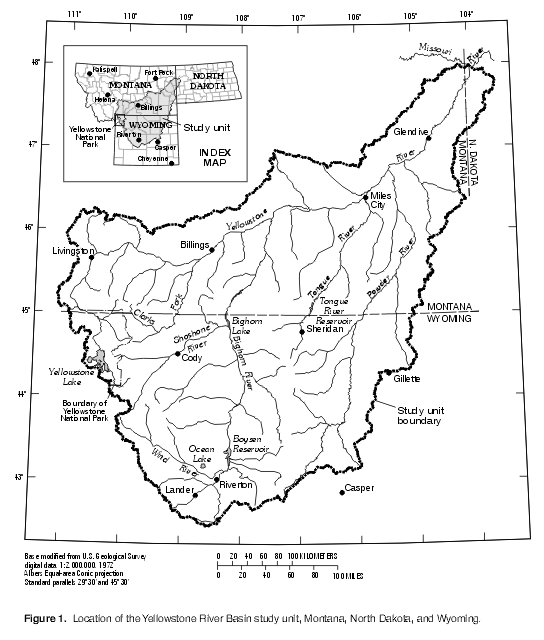
The Yellowstone River is the largest tributary of the Missouri River and drains an area of approximately 182,000 square kilometers (70,000 square miles) in Montana, North Dakota, and Wyoming (fig. 1). The mean annual discharge of the Yellowstone River at gaging-station 06329500 near the mouth is 362 cubic meters per second (12,800 cubic feet per second) (Shields and others, 1999, p. 346). Major tributaries to the Yellowstone River include the Clarks Fork Yellowstone, Wind/Bighorn, Tongue, and Powder Rivers.
Air masses originating in the Gulf of Mexico, the northern Pacific Ocean, and the Arctic region interact to produce the seasonal climatic regimes of the study unit. Mean annual precipitation ranges from about 150 mm (5.9 in.) in the central parts of the Bighorn and Wind River Basins to more than 1,500 mm (59 in.) at high elevations in the mountains near Yellowstone National Park (Oregon Climate Service, 1995a, 1995b). Snowfall composes a substantial part of annual precipitation in most years, with average annual snowfall ranging from less than 300 mm (12 in.) in parts of the Bighorn Basin to more than 5,200 mm (200 in.) near Yellowstone National Park (Western Regional Climate Center, digital data, 1997). In mountainous parts of the study unit, precipitation varies strongly with elevation.
The ecoregions shown on plate 1 were modified from Omernik's map (1987) of ecoregions, and are based on integrated patterns of factors including land use, morphology, potential natural vegetation, and soil. Approximately 55 percent of the study unit lies in the Northwestern Great Plains ecoregion (Zelt and others, 1999, p. 75). This ecoregion has plains with open hills of varying height and tablelands of moderate relief; predominant land cover is subhumid grasses used for grazing (Omernik, 1987). The Middle Rocky Mountains and Wyoming Basin ecoregions each contain about 21 percent of the study unit (Zelt and others, 1999, p. 75). The Middle Rocky Mountains ecoregion features high mountains and plateaus covered by Douglas fir, western spruce-fir forests, and alpine meadows (Omernik, 1987); land use includes grazing and silviculture. The Wyoming Basin ecoregion has plains with hills or low mountains, some irrigated agriculture, and the potential natural vegetation is shrub steppe, desert shrubland, and juniper-pinyon woodland (Omernik, 1987). The Montana Valley and Foothill Prairies ecoregion contains the remaining 3 percent of the study unit. The Montana Valley and Foothill Prairies ecoregion is characterized as subhumid grassland used for grazing, and some irrigated land (Omernik, 1987).
The ecoregions correspond in part to the structural geologic framework of uplifts and sedimentary basins in the study unit. The Beartooth Mountains, the Absaroka Range, the Wind River Range, and the Bighorn Mountains (plate 1) are the major uplifted areas that, in combination with two volcanic fields (the Yellowstone Plateau and the Absaroka field), compose most of the Middle Rocky Mountains ecoregion. The Beartooth Mountains contain a core of crystalline gneiss, granitics, and supracrustal rocks of Precambrian age (Page and Zientek, 1985), flanked primarily by rocks of Paleozoic age and younger rocks. Along the northern edge of the Beartooth Mountains, the Stillwater Complex of Precambrian age (not shown on plate 1), a layered igneous intrusion containing mineralized areas, crops out over an area about 50 km long and up to 8 km wide (Page, 1977). The Stillwater Complex contains nationally important resources of chromium and platinum-group elements, as well as substantial resources of gold, silver, copper, lead, and zinc (Hammarstrom and others, 1993). The crystalline core of Precambrian age of the Wind River Range is a high-grade metamorphic and igneous complex of migmatite, orthogneiss, and paragneiss, intruded by quartz diorite to granitic plutons (Hausel, 1989, p. 160-161). Rocks of Paleozoic age, and to a lesser extent Cretaceous age, are exposed along the eastern flank of the Wind River Range. The Bighorn Mountains represent a major structural arch with a core of crystalline granitic and gneissic rocks of Precambrian age (Hausel, 1989, p. 34-37). Throughout much of the Bighorn Mountains, the crystalline rocks of Precambrian age remain buried beneath carbonate rocks of Paleozoic age.
The Yellowstone Plateau of Quaternary age and the Absaroka volcanic field of Tertiary and Cretaceous age are recognized as distinct geologic provinces (Snoke, 1993). Rhyolites predominate among rock types in the Yellowstone Plateau, but basalts also occur. Andesite and dacite are the primary rock types in the Absaroka volcanic field (Chadwick, 1970), which encompasses the Absaroka Range and surrounding areas (plate 1). Many of the historical and recent metal-mining districts in the study unit are associated with the principal vent complexes, intrusives, and eruptive centers in the Absaroka volcanic field, as shown by Chadwick (1970). High concentrations of copper, gold, silver, zinc, lead, and other metals were deposited in the Absaroka volcanic field, the Beartooth Mountains, and surrounding areas in various types of deposits, such as porphyries, intrusions, veins, and zones of hydrothermal alteration and mineralization (Hammarstrom and others, 1993).
Structural basins in the study unit include the Bighorn Basin and Wind River Basin, which are both in the Wyoming Basin ecoregion (plate 1). The Wyoming Basin ecoregion spans the Bighorn and Wind River basins and the Owl Creek and Bridger Mountains that separate the two basins. The Powder River and Williston Basins are in the northeastern part of the study unit. The structural basins are surrounded on the flanks of the adjacent uplifts by folded and faulted rocks of Cretaceous and Paleozoic age. Rock units of Cretaceous age crop out in about 23 percent of the study unit, and usually are tilted and often beveled by erosion. Sedimentary rocks of Tertiary age unconformably overlie the eroded Cretaceous surface in most of the plains and basins of the study unit. Sedimentary rocks of Tertiary age, including sandstone, mudstone, siltstone, and shale crop out over about 43 percent of the study unit. Commercially important deposits of uranium occur in rocks of Tertiary age in the Powder River Basin and the Wind River Basin. The sedimentary rocks can be several thousand meters thick in the structural basins of the study unit (Blackstone, 1993).
A great variety of deposits of Quaternary age occur within the study unit, including eolian, fluvial, glacial, and landslide deposits. Valley-fill deposits consisting of unconsolidated gravel, sand, silt, and clay occur adjacent to most of the larger streams of the study unit (Whitehead, 1996), but are not shown on plate 1 because the sediment composition is considered to be reflective of the adjacent geologic setting.
All of the HSSR bed-sediment samples from the YRB were collected under the direction of the Los Alamos Scientific Laboratory in Los Alamos, New Mexico. All 13,523 samples were collected in the YRB during 1976-79, except for two samples collected in 1974. Sampling sites were selected to represent small drainage areas of about 10 km2 (Sharp and Aamodt, 1978, p. 9). The relatively small targeted drainages increased the likelihood that the bed sediment reflected the local geology. Downstream sediment transport undoubtedly affects element concentrations in the sediment at any given site, but the extent of the effect is unknown and beyond the scope of this report.
Each sediment sample was a composite of three grab samples from a cross section or along the margins of the stream channel. A similar procedure was followed if the stream was dry. The bed-sediment samples were dried at 100oC or less and sieved in the field (Sharp and Aamodt, 1978, p. 16-19). About 25 cubic centimeters of the smaller particles (sand, silt, and clay-size) were shipped to the laboratory for elemental analysis. The sieve mesh size was 150 microns for 13,124 samples. The remaining 399 samples were sieved through 180-micron mesh and were excluded from this report because of the different mesh size. Bed-sediment samples often are sieved to minimize grain-size effects, but the mesh size used for sieving is not widely standardized. Comparing element concentrations of samples sieved with different mesh sizes is difficult because concentrations commonly are inversely related to grain size (Horowitz, 1991, p. 16-22).
Most of the samples were analyzed at the Los Alamos Scientific Laboratory (fig. 2). Due to program changes, some of the samples were analyzed at the Oak Ridge National Laboratory in Oak Ridge, Tennessee. The sampling and analysis efforts were subdivided into blocks corresponding to U.S. Geological Survey 1° x 2° quadrangle series maps. Samples from the Driggs, Ekalaka, and Sheridan quadrangles were analyzed for uranium at Los Alamos and for the other 49 elements at Oak Ridge.
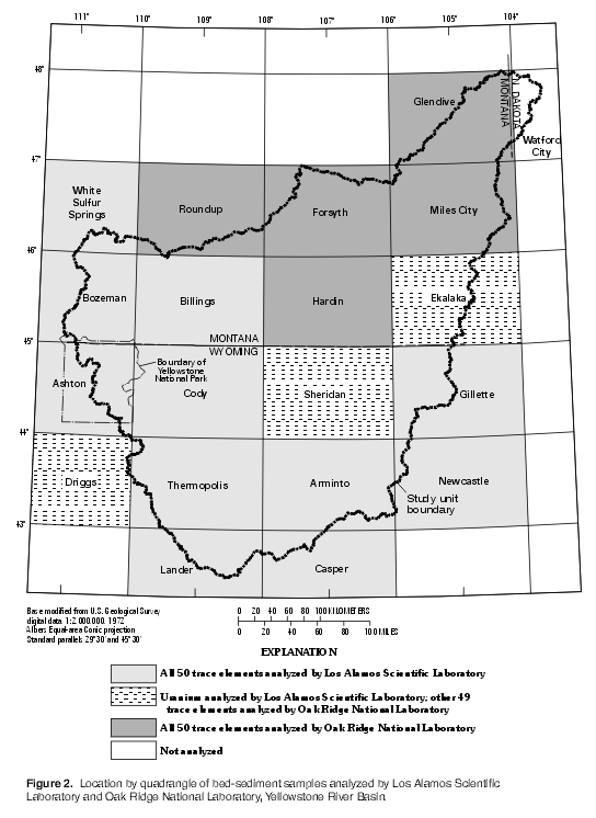
The Los Alamos laboratory analyzed samples for uranium using delayed neutron counting; for arsenic, bismuth, cadmium, copper, lead, molybdenum, nickel, niobium, selenium, silver, tin, tungsten, and zirconium using energy dispersive x-ray fluorescence; for beryllium and lithium using arc-source emission spectrography; and for the remaining elements using neutron-activation (Smith, 1999). Elements typically analyzed by Los Alamos but not Oak Ridge included antimony, bismuth, cadmium, cesium, chloride, dysprosium, europium, gold, lutetium, rubidium, samarium, tantalum, terbium, tin, tungsten, and ytterbium. The Oak Ridge laboratory analyzed samples for uranium using neutron-activation and for the other elements using emission spectrochemical analysis. Elements analyzed by Oak Ridge but not Los Alamos included boron, molybdenum, phosphorus, yttrium, and zirconium. Some exceptions occurred, such as special studies of arsenic, molybdenum, selenium, and zirconium, which were analyzed only in samples collected from quadrangles on the western edge of the study unit. Quality-control samples were not available to compare results between the two laboratories.
Factor analysis (Kachigan, 1986, p. 377-379) was used as a data-reduction technique to systematically summarize the large correlation matrix formed among the constituent-concentration variables. The purpose of factor analysis is to represent the variance in the concentrations through computation of a small set of derived variables called factors that commonly correspond to underlying geochemical processes (Christophersen and Hooper, 1992) or patterns of spatial variability (Lins, 1997). The first factor accounts for as much of the total variance in the data as possible, the second factor accounts for as much of the remaining variance as possible while being uncorrelated with the first factor, and so forth (Alley, 1993, p. 49). The factor analysis was performed using Statit Analysis System software (Statware, Inc., 1996). Probability plots indicated that the frequency distributions of the elements were right-skewed. Therefore, logarithms of the constituent-concentration values were used as input to factor analysis to improve the multivariate normality of the data set.
Orthogonal varimax rotation was applied to the factors to maximize the total variance explained by the factors as a whole. The purpose of rotation is to redefine the factors in order to make sharper distinctions, because rotation does not change the number of factors or the total variance explained by the factor analysis (Kachigan, 1986, p. 389-393).
For each sample, a score was computed on each factor. These factor scores represent a weighted combination of the sample's chemical composition, as indicated by the concentrations of the elements. A sample will tend to score high on a factor only if it had large concentrations of the constituents that correlate most strongly with that factor (Kachigan, 1986, p. 385). Scores for each factor were standardized; that is, the mean score is zero with unit variance.
The authors wish to thank the USGS people that helped prepare this report and guide it through the various stages of review. Critical reviews from Ingrid Verstraeten and Robert Boyd are greatly appreciated. Steve Smith provided electronic access to the HSSR data. We also thank Melanie Clark for assisting with data retrieval, Peter Wright for assisting with data inventory, and Laura Gianakos for assisting with data compilation. Sue Roberts, Phil Bowman, Emily Sabado, and Shirley Thomas assisted with preparation of graphics, text, and tables.
Return to CONTENTS
| AccessibilityFOIAPrivacyPolicies and Notices | |
 |
|