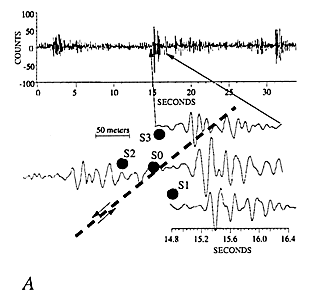
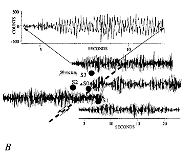
Figure 4.-- Seismic ground motions recorded on the Slumgullion landslide. All traces shown were recorded by the digital micro-array and are plotted on the same amplitude and time scales. Only vertical-component seismograms are shown, each was recorded by the sensor denoted by the nearest corresponding shaded circle (sensors are shown in "map view" similar to that shown in fig. 2-- 50-m scale bar refers to map view of sensors). The top trace spans a longer duration and includes the segment shown from sensor S3. A, Seismograms of probable slidequakes.
B, Sinusoidal-like seismograms.

![]() U.S. Department of the Interior |
U.S. Geological Survey
U.S. Department of the Interior |
U.S. Geological Survey
URL: http://pubsdata.usgs.gov/pubs/bul/b2130/ch14fig4.htm
Page Contact Information: GS Pubs Web Contact
Page Last Modified: Friday, 23-Mar-2012 14:25:15 EDT