
| ||||
Persistent unrest in Long Valley Caldera-characterized by recurring earthquake swarms, inflation of the resurgent dome in the central sections of the caldera, and emissions of magmatic carbon dioxide around Mammoth Mountain-during the last two decades and continuing into the 21st century emphasize that this geologically youthful volcanic system is capable of further volcanic activity. This document describes the U.S. Geological Survey's (USGS) response plan for future episodes of unrest that might augur the onset of renewed volcanism in the caldera or along the Inyo-Mono Craters chain to the north. Central to this response plan is a four-level color code with successive conditions, GREEN (no immediate risk) through RED (eruption under way), reflecting progressively more intense activity levels as summarized in table 1 and 2 and described in detail in section II.
Key response activities specified under this plan include:
The nature and intensity of activity determining a condition level (color code) are based on recent activity within Long Valley Caldera since 1978, as summarized in Appendix A, plus well-documented case histories of precursory activity to volcanic eruptions elsewhere in the world. Although such information provides an invaluable basis for judging whether activity may lead to an eruption, it is not sufficient in itself to support robust probabilistic calculations that activity associated with a given color-code will culminate in an eruption. Thus, lacking a record of precursory activity to earlier eruptions from the Long Valley Caldera-Mono Craters (LVC/MC) system (the most recent of which occurred about 250 years ago), we do not attempt to assign numerical probabilities that the activity associated with a given color code will lead to an eruption. In this regard, it is important to recognize that the criteria governing the transition between the above Conditions as spelled out in section II serve as guidelines only. Personal judgment and experience will inevitably play a critical role in decisions on the transition from one color-code to the next. Final decisions on color-code transitions rest solely with the LVO SIC in consultation with other scientists involved in the response, the LVO Science Advisory Team, and the USGS Volcano Hazards Team Chief Scientist (see section III).
The data that provide the basis for monitoring activity levels in Long Valley Caldera and vicinity derive from a system of geophysical, geochemical, and hydrological instrumentation networks that first became operational in mid-1982. As described in appendix D, the data from most of the installed instrumentation in these networks are telemetered to computers in USGS offices in Menlo Park, California, the LVO field office in Mammoth Lakes, California, and the USGS Cascades Volcano Observatory (CVO) in Vancouver, Washington, for automatic, real-time processing and immediate analysis. Thresholds for specific activity levels are programmed into these computers to send round-the-clock pages to the LVO Scientist-in-Charge and others with monitoring responsibilities.
Those wishing to skip the technical and scientific details in this document should focus on the Introduction (section I), the first six headings under Condition code thresholds (section II), and the section on Organization and response (section III). For a description of the type of activity to expect if an eruption does occur, see the heading "Character of Possible Eruptive Activity" under Appendix A.
Those interested in the scientific and technical background may wish to read appendix A for a summary of the geologic setting and the activity in the area since 1978. The Appendices contain discussions of additional technical issues, including the scientific rationale behind the color-code transition criteria and descriptions and examples of various types of earthquakes commonly recorded in volcanic areas (appendix C).
Additional information on the Long Valley Caldera and the Mono-Inyo Craters volcanic system and its current activity is available through the LVO web page at http://lvo.wr.usgs.gov.
Long Valley Caldera and the Mono-Inyo volcanic chain in eastern California form one of several geologically youthful volcanic systems in California that pose potential hazards to nearby population centers from future volcanic eruptions (Miller, 1989). The recurring earthquake swarms and episodes of ground uplift (particularly the uplift centered on Long Valley Caldera's resurgent dome) that dominated the geologic unrest in Long Valley Caldera through the 1980's and 1990's (see figs. 1, 2 and appendix A) emphasize that this large silicic magmatic system is still active and capable of producing volcanic eruptions (Bailey and Hill, 1990; Farrar and others, 1995; Hill, 1996; Hill, Bailey, and Ryall, 1985a; Hill, Wallace, and Cockerham, 1985b; Langbein and others, 1993; McGee and Gerlach, 1998; Rundle and Hill, 1988; Sorey and others, 1998). This document outlines USGS plans for responding to future episodes of unrest and onset of possible volcanic activity in the vicinity of the caldera and the Mono-Inyo volcanic chain. It updates and supersedes OpenFile Reports 84-500 (U.S. Geological Survey, 1984) and 91-270 (Hill and others, 1991).
Sections II and III form the core of this document. Section II defines a four-level condition-code tied to successively more intense levels of geologic unrest detected on networks that monitor seismic activity, ground deformation, and stressinduced variations in the magnetic field intensity. Section III outlines the USGS's response to various levels of unrest and the corresponding color-code condition.
The four-level color-code conditions (tables 1 and 2) were developed in collaboration with Mono County, the Town of Mammoth Lakes, the California Earthquake Prediction Evaluation Council (CEPEC) and the California Division of Mines and Geology (CDMG). It was formally adopted in June 1997 in an effort to simplify and clarify the five-level, alphabetic (E through A), status system initially adopted in 1991 and described in Open File Report 91-270 (Hill and others, 1991). The alphabetic system, which was based on a similar scheme developed for the Parkfield earthquake prediction experiment (Bakun, and others, 1987), was abandoned after experience showed that it was prone to misinterpretation by both the media and the public when applied to volcanic unrest in Long Valley Caldera (Hill, 1998).
The color-code system through
condition ORANGE is based on activity levels and rates for premonitory activity
commonly observed prior to the onset of a volcanic eruption. Once underway,
however, volcanic eruptions commonly show a wide range of behavior involving
multiple eruptive phases that may play out over months to years and even decades.
The four levels under condition RED (eruption underway) corresponds to varying
intensities of eruptive activity and their likely impacts.
A principal objective of this document is to facilitate communication of the
significance of scientific information derived from monitoring measurements
to local, state, and Federal officials. Specifically, the color codes described
in section II provide a graded measure of our concern about how a given level
of unrest might threaten local communities with a possible volcanic eruption.
The use of a color-code scheme for volcano status or activity levels, which
is becoming widely adopted for many volcanoes, offers civil authorities and
the general public an intuitive, easily understandable framework for gauging
and coordinating a response to developing volcano crisis. Worldwide experience
in recent decades demonstrates that effective communication among scientists,
civil authorities, and the population affected is a prerequisite-indeed, perhaps
the single most important element-to mitigate the risk from potentially hazardous
volcanoes.
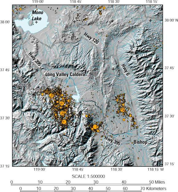
Figure 1. Shaded relief map of the Long Valley Caldera-Mono Craters region showing the epicenters of magnitude (M) greater than or equal to 3 earthquakes for 1978 through 1999 (see fig. 2 for selected place names). Circles represent earthquake magntiude in four steps from M=3.0 to M=6.0.
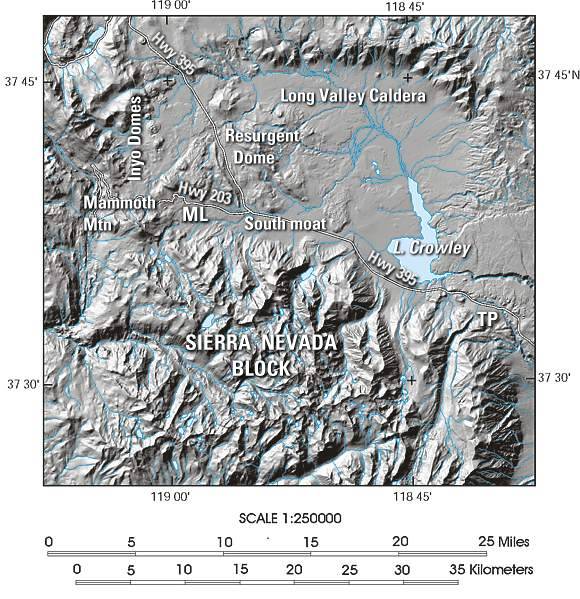
Figure 2. Shaded relief map of the Long Valley Caldera and the Sierra Nevada block to the south with dominant geologic/topographic structures labeled. ML Mammoth Lakes, TP, Tom's Place.
The guidelines for relating activity levels to the color-code conditions in table 1 are summarized in table 2. In this section, we expand on and describe the basis for the specific choices in the types and levels of activity that serve as these transition criteria. These criteria apply only to activity within the confines of the caldera, beneath Mammoth Mountain, and along the Mono-Inyo volcanic chain. In particular, they do not apply to seismic activity in adjacent areas, such as the Sierra Nevada block south of the caldera, the upper Owens Valley, or the Chalfant Valley that, based on the geologic record, are unlikely sites for the onset of volcanic activity in the near future.
| CONDITION | USGS RESPONSE1 | ACTIVITY LEVEL | RECURRENCE INTERVAL2 |
|---|---|---|---|
|
GREEN—No immediate risk
|
Normal operations plus information calls to local and other authorities for weak through strong unrest as appropriate | Background or quiescence | Most of the time |
| Weak Unrest | Days to weeks | ||
| Minor Unrest | Weeks to months | ||
| Moderate-to-Strong Unrest | Months to years | ||
|
YELLOW (WATCH)
|
Full calldown and EVENT RESPONSE | Intense Unrest | Years to decades |
|
ORANGE (WARNING)
|
Full and calldown and EVENT RESPONSE (if not already in place under YELLOW) | Accelerating intense unrest: eruption likely within hours to days | Decades to centuries |
|
RED (ERUPTION IN PROGRESS)
|
Full and calldown and EVENT RESPONSE
(if not already in place under YELLOW OR ORANGE)
Daily or more frequent updates on eruption levels |
LEVEL 1: Minor eruption | Centuries |
| LEVEL 2: Moderate explosive eruption | Centuries | ||
| LEVEL 3: Strong explosive eruption | Centuries | ||
| LEVEL 4: Massive explosive eruption | Centuries to millennia |
1USGS response for a given condition will include the responses specified for all lower conditions.
2Estimated recurrence intervals for a given condition are based primarily on the recurrence of episodes of unrest in Long Valley Caldera since 1980, the record of M>4 earthquakes activity in the region since the 1930's, and the geologic record of volcanic eruptions in the region over the past 5,000 years.
Activity under condition GREEN includes a range of unrest levels that, based on the history of unrest in Long Valley Caldera since 1980 and case histories from other calderas and volcanic systems, pose no immediate risk in terms of a volcanic eruption developing in the short term (days to weeks). The four activity levels under condition GREEN (table 2) depend principally on seismicity criteria with the constraint that strain rates remain below ~ 0.1 ppm/day (here we use ppm, or parts per million, to include both strain (microstrain) and tilt (microradians)) or comparable deformation rates 0.5 mm/day. Such changes over a 24-hour period are below the resolution of both the 2-color EDM and continuous GPS measurements but resolvable by the borehole dilatometers and tiltmeters. The activity levels range from relative quiescence (a few M<2 earthquakes per day and no detectable ground deformation) to relatively strong unrest. The latter may involve an earthquake swarm with several hundred earthquakes per day, a number of which may be locally felt (generally M>3), with perhaps a few as large as M=4. Ground deformation may involve strain rates as high as several tenths of a microstrain (ppm) per day. Also included under condition GREEN is the diffuse emission of CO2 gas from around the flanks of Mammoth Mountain at flux rates that average a few hundred tons per day (Gerlach and others, 1999; Sorey and others, 1998). These activity levels, which correspond to status levels N, E, D, and C in the previous, alphabetic system (Hill and others, 1991), have recurred frequently in the caldera since 1980. The November-December swarms of 1997 certainly qualified as "strong unrest" and, as described under Recent Unrest (appendix A), this activity came close to meeting the criteria for condition YELLOW.
| CONDITION GREEN — No Immediate Risk |  |
|
| ACTIVITY LEVEL | GEOLOGIC BEHAVIOR | USGS RESPONSE |
|---|---|---|
| Background or Quiescence | Background typically includes several M~2 earthquakes/day with 10-20 smaller events and CO2 emissions at Mammoth Mtn <500 t/day | Normal operations. |
| Weak Unrest |
Any of the following with strain rates <0.1 ppm/day or displacements less than 1 mm/week and CO2 emissions <500 t/day
|
Discretionary information calls to project scientists and or local authorities as appropriate. |
| Minor Unrest |
Any of the following with strain rates <0.1 ppm/day or displacements <1 mm/week and CO2 emissions <500 tons/day
|
Information calls to project scientists and discretionary infomration calls to local authorities as appropriate. |
| Moderate-to-Strong Unrest |
Any combination of the following:
|
Information calls to project scientists, Californai Office of Emergency Services (OES) and local authorities. A heads-up calldown if increasing activity rates approach the criteria for condition YELLOW (see below). |
| CONDITION YELLOW (WATCH) |  |
|
| ACTIVITY LEVEL | GEOLOGIC BEHAVIOR | USGS RESPONSE |
|---|---|---|
| Intense Unrest |
A swarm and one or more M 5 or greater earthquakes, >5 M 4 or greater earthquakes, or >30 M 3 or greater earthquakes/day OR Average strain rates of >1 ppm/day or displacements of >5 mm/day
on 3 or more instruments sustained for >48 hours
|
Calldown notification of change to condition YELLOW EVENT RESPONSE
A heads-up calldown if activity looks as though it is rapidly evolving toward a condition ORANGE |
| CONDITION ORANGE (WARNING) |  |
|
| ACTIVITY LEVEL | GEOLOGIC BEHAVIOR | USGS RESPONSE |
|---|---|---|
| Accelerating Intense Unrest: ERUPTION LIKELY within hours to days |
Average strain rates of >10 ppm/day or displacements of >50 mm/day on 3 or more instruments sustained for >24 hours AND any of the following
|
Calldown notification of change to condition ORANGE EVENT RESPONSE (If not already in effect under condition YELLOW)
|
| CONDITION RED (ERUPTION IN PROGRESS) |  |
|
| ACTIVITY LEVEL | GEOLOGIC BEHAVIOR | USGS RESPONSE |
|---|---|---|
| LEVEL 1: Minor eruption underway |
Eruptive activity characterized by any of the following:
|
Calldown notification of change to condition RED EVENT RESPONSE (If not already in effect under condition YELLOW or ORANGE)
Communicate changes in eruption levels and associated hazard zone to civil authorities through daily to hourly updates. |
| LEVEL 2: Moderate eruption underway |
Explosive eruptive activity characterized by:
|
|
| LEVEL 3: Strong eruption underway |
Explosive eruption characterized by:
|
|
| LEVEL 4: Massive eruption underway |
Explosive eruption characterized by:
|
|
Under condition YELLOW, activity is sufficiently intense to warrant a USGS on-site response as a basis for expanded monitoring in the field and direct communication with local civil authorities. The criteria for condition YELLOW places comparable importance on both seismicity and deformation rates. The transition to condition YELLOW, for example, may be prompted by either an intense earthquake swarm within the caldera or along the Mono-Inyo volcanic chain including one or more M>5 earthquakes and (or) deformation with strain or deformation rates exceeding 1 ppm/day or 5 mm/day, respectively, sustained for at least two days. In general, we would expect deformation rates at these levels to be accompanied by elevated seismicity rates, the onset of shallow volcanic earthquakes (including harmonic tremor), or perhaps increased flux rates of CO2 or SO2. Instrumental indications of possible increased deformation rates without such corroborating signs of magmatic or tectonic processes must be viewed as suspicious and carefully checked for alternate explanations (such as meteorological effects or instrumental problems). Had this color code system been in effect prior to the onset of unrest in 1980, condition YELLOW would have been attained twice-once during the May 1980 sequence, which included four M=6 earthquakes, one of which was inside the caldera, and once during the January 1983 swarm, which included two M=5.3 earthquakes in the south-moat seismic zone (SMSZ) of the caldera.
A condition ORANGE and the likelihood that an eruption may develop within hours to days depends primarily on pronounced and accelerating ground deformation with sustained rates exceeding 50 mm/day (strain rates >10 ppm/day) for at least 24 hours, consistent with the intrusion of magma into the shallow crust. Such an intrusion will almost certainly be accompanied by intense earthquake activity, although the seismic swarm itself may not necessarily be any more intense than that under a condition YELLOW. Supporting activities under the criteria for the transition to condition ORANGE include frequent, shallow long-period (LP) volcanic earthquakes, sustained harmonic tremor, and (or) flux rates of CO2 or SO2 exceeding 10,000 or 1,000 tons/day, respectively (table 2).
Note that the transition to condition ORANGE does not necessarily require an increase in the intensity of earthquake swarm activity above that already specified for condition YELLOW for the following reasons:
(To date, early 2002, no activity levels corresponding to condition ORANGE have been observed in Long Valley Caldera.)
The transition to condition RED is triggered by the onset of a volcanic eruption. Under this document, the onset of a volcanic eruption coincides with the initial explosive or effusive eruption at the surface of particulate and (or) fluid material. Condition RED will be attained with any of the following activities: phreatic (steam) blasts, emergence of a lava dome (the passive extrusion of viscous lava flows), onset of lava fountains (such as with basaltic eruptions in Hawaii), or the onset of explosive ash eruptions. We include a phreatic blast here because (1) it is often only possible in hindsight to determine with confidence that an explosion is phreatic or magmatic, and (2) phreatic blasts may be followed in short order (minutes to hours) by the eruption of fresh magma. The latter is particularly true for the eruption of highly fluid, basaltic magmas of the sort that produced the Red Cones south west of Mammoth Mountain and lava flows that extend from the west moat of Long Valley Caldera down both the south and north moats.
Unlike a major earthquake, which is usually followed by declining activity in the form of an aftershock sequence, the onset of a volcanic eruption usually represents just the beginning of a prolonged crisis that may persist for days, weeks, months, or even years. Quite commonly, the strongest, most hazardous phase of an eruption develops days to weeks (but occasionally months to years) after the eruption onset. To account for varying intensities in eruptive activity once an eruption is underway, condition RED is subdivided into four levels [levels 1 through 4 correspond roughly to the Volcanic Explosivity Index (VEI) levels 1 through 4 (Newhall and Self, 1982); the principal difference is that Level 1 includes both VEI 0 and 1 and Level 4 includes VEI 4 and greater]:
The criteria specified for each Color-Code transition as described above and outlined in table 2 serve as guidelines only. In particular, these criteria must not be viewed as a rigid, infallible recipe (algorithm) that invariably leads to the appropriate designation of a Color-Code condition and response. PERSONAL JUDGMENT AND EXPERIENCE WILL INEVITABLY PLAY A CRITICAL ROLE IN DECISIONS ON THE TRANSITION FROM ONE COLOR CODE TO THE NEXT. Final decisions on Color-Code transitions will be made by the Long Valley Observatory Scientist-in-Charge in consultation with other scientists involved in the event response, the Science Advisory Team, and the Chief Scientist for the Volcano Hazards Team.
Two issues deserve special emphasis in this regard:
Following the onset of episodic activity in Long Valley Caldera in 1980, each of the unrest episodes has eventually declined to low-level or background activity (condition GREEN). Most future episodes of unrest will likely do the same. Table 3 specifies the criteria for standing down from a given color condition after the activity triggering that condition has decreased in intensity below the transition criteria.
The standdown criteria of table 3 specify a minimum time interval that a given color condition will remain in effect after activity triggering the condition as fallen below the threshold for that condition. At the end of a specified time interval, the condition will automatically drop to the next lower level consistent with any ongoing activity unless explicitly extended by the Scientist-in-Charge for the Long Valley Observatory.
The intense activity that warrants a condition YELLOW also triggers an EVENT RESPONSE and an intensive field monitoring effort within the caldera (section III). The USGS will continue intensive field monitoring for two weeks after the activity falls below the criteria for condition YELLOW to insure continuity of field data and to minimize remobilization costs in case the drop in activity is only a temporary lull. Evidence from volcanoes worldwide suggests that, in many cases, a temporary quiescence interrupts the unrest leading to an eruption just prior to the initial outbreak of the eruption. This premonitory quiescence, should it occur, commonly lasts a few hours to a few days (Shimozuru and Kagiyama, 1989). Accordingly we will normally extend a condition ORANGE for one week beyond the time activity drops below the threshold for condition ORANGE and then drop to a condition YELLOW and continue intensive field monitoring for a second week. If the activity has remained at a level consistently below the criteria for a condition YELLOW for this entire twoweek period, we will drop to tche level under condition GREEN consistent with the level of activity at the time.
Condition RED indicates an eruption in progress, and the four levels within condition RED indicate the current intensity of the eruptive activity. The condition will revert to ORANGE within 24 hours of the cessation of eruptive activity. Likewise, in the case of waning eruptive activity, the condition will drop to the level consistent with the current activity within 24 hours after the more intense eruptive phase has stopped. The 24-hour delay is intended to minimize frequent (and potentially confusing) switching between RED and ORANGE or between levels within RED in the case of rapidly fluctuating changes in eruption intensity or sporadic low-level eruptive activity over an extended duration.
| CONDITION | EXPIRES AFTER* | SUBSEQUENT CONDITION |
|---|---|---|
Weak Unrest Minor Unrest Moderate-to-Strong Unrest |
|
GREEN Background Weak Unrest Minor Unrest |
14 days |
GREEN (to appropriate Unrest level under green) | |
7 days |
YELLOW | |
|
1 day |
ORANGE |
*Number of days after the activity level falls below the threshold for a given CONDITION.
This section describes the USGS organizational structure for response to activity in the Long Valley Caldera-Mono Craters (LVC/MC) region. This structure is based on that described IN USGS OpenFile Reports 84500 (U.S. Geological Survey, 1984) and 91-270 (Hill and others, 1991) but modified to incorporate the color code defined in table 1 and organizational changes within the USGS since OFR 91-270 was released.
The Long Valley Observatory
is one of five volcano observatories within the Volcano Hazards Team and under
the overall supervision of the Volcano Hazards Team Chief Scientist (fig. 3).
The Volcano Hazards Team is part of the Geologic Discipline in the Western Region
of the U.S. Geological Survey, and it is located in the USGS Menlo Park, California,
campus. The diagram in figure 4 illustrates how LVO fits in this organizational
structure during normal conditions (GREEN), when the Long Valley Observatory
Scientist-in-Charge (LVO SIC) has the role of coordinating monitoring, hazard
assessment, and public information activities in the Long Valley CalderaMono
Craters region as they are carried out under normal USGS management channels.
The organizational structure for LVO during an EVENT RESPONSE (conditions YELLOW
through RED), however, is illustrated in figure 4. During an EVENT RESPONSE,
the LVO SIC derives authority from the USGS Director's Office through the Western
Regional Geologist to direct all USGS activities concerning the response.
The Western Regional Geologist (WRG) is responsible for overseeing and coordinating geological investigations and response activities in the Western Region for the USGS. This responsibility includes general oversight of USGS response to both earthquake and volcanic crises. The WRG has the authority to declare an EVENT RESPONSE when the Long Valley Observatory Scientist-in-Charge has determined that condition YELLOW or higher is in effect in the Long Valley Caldera-Mono Craters region.
The Chief Scientist for the Volcano Hazards Team (TCS) has overall responsibility under both routine and EVENT RESPONSE conditions for monitoring, hazards assessment, and all operations relating to volcanic and earthquake hazards in the Long Valley Caldera-Mono Craters region (fig. 3). The TCS is responsible for ensuring that accurate summaries of geologic, monitoring, and hazards information are prepared and transmitted as frequently as conditions require to the Western Regional Geologist and the Director's Office, as well as to the California Division of Mines and Geology and the California Office of Emergency Services. The TCS is also responsible for ensuring that policies and instructions of the Western Regional Geologist are transmitted to, and followed by, personnel under their direction. The TCS is assisted, as necessary, by the Coordinator of the Volcano Hazards Program.
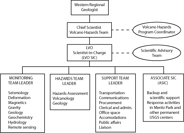
Figure 3. Organizational structure for the Long Valley Observatory under normal (noncrisis) operation (condition GREEN). Rectangles represent positions of line authority; ovals and dashed lines represent input from advisory positions or groups. USGS, U.S. Geological Survey; LVO, Long Valley Observatory; SIC, Scientist-in-Charge; ASIC, Associate Scientist-in-Charge.
During periods of routine activity, the Long Valley Observatory Scientist-in-Charge (LVO SIC) acts as a coordinator and works through the appropriate line managers to coordinate monitoring, hazards assessment, and information dissemination for the Long Valley Caldera - Mono Craters region. The SIC ensures that the USGS is in an appropriate state of readiness for a timely response to increased activity in the region, as spelled out in the color code of Table 1. The SIC ensures that monitoring and hazards assessment are conducted efficiently, effectively, and thoroughly, and that activities of LVO are summarized in the form of quarterly or other periodic and interim reports and that these are distributed in a timely manner. The SIC also ensures that the monitoring and hazards data are adequately analyzed and periodically reviewed for scientific quality and completeness. This review process should include periodic meetings of all monitoring and hazards assessment personnel, as well as meetings and discussions with the Scientific Advisory Team, relevant USGS managers, and the LVO team leaders (see fig. 3), as appropriate. The SIC is responsible for ensuring that accurate and timely hazards assessments and supporting scientific information are issued to all concerned parties, including local, state, and Federal officials and the public.
When activity within the caldera or along the Inyo-Mono volcanic chain becomes sufficiently intense to prompt the declaration of an EVENT RESPONSE (based on condition YELLOW or above) by the Western Regional Geologist, the LVO SIC initiates the establishment of the center for LVO operations in the Mammoth Lakes Field Office and ensures that all relevant monitoring, hazards, and support personnel are rapidly mobilized and dispatched to field office and, as appropriate to the backup operations center in the Mono County Sheriff's Office in Bridgeport (fig. 4). Under these EVENT RESPONSE conditions, the LVO SIC has full authority from the USGS Director (see appendix F) to direct all USGS personnel engaged in the response, wherever physically or organizationally located, and to call upon the resources of all USGS units assigned to and necessary for monitoring, hazards assessment, and support activities (see Response and General Operational Procedures below).
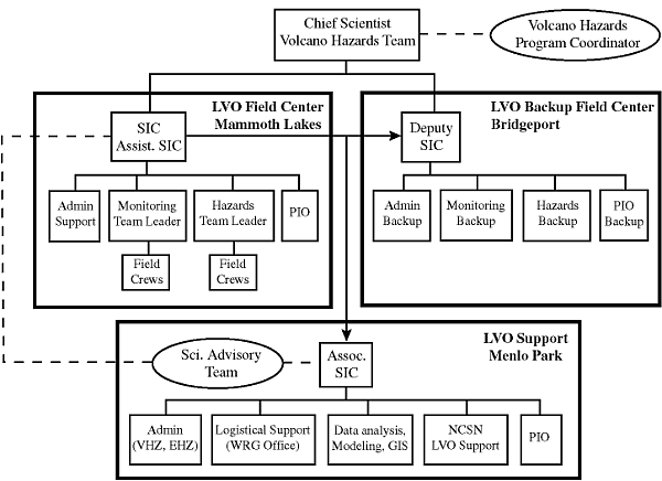
Figure 4. Organizational structure for the Long Valley Observatory under an EVENT RESPONSE (conditions YELLOW, ORANGE, or RED). Rectangles and solid lines indicate line authority; dashed lines and oval indicate advisory communication paths; heavy rectangles outline organizational units. LVO, Long Valley Observatory; GIS, Geographical Information System; NCSN, Northern California Seismic Network; PIO, Public Information Officer; VHZ, Volcano Hazards Team; EHZ, Earthquake Hazards Team; SIC, Scientist-in-Charge; WRG, Western Region Geologist.
To assist the LVO Scientist-in-Charge are three team leaders-Monitoring Team Leader, Hazards Assessment Team Leader, and Support Team Leader (fig. 3). During routine activity, these Team Leaders act as coordinators for their respective functions and work through normal management channels while assisting the LVO SIC to accomplish his or her goals. Under EVENT RESPONSE conditions, however, these Team Leaders report directly to the LVO SIC and, through the SIC, have full authority to issue instructions to their respective team members, determine team strategy, and assign necessary personnel to specific tasks.
The Monitoring Team Leader serves as a consultant and advisor to the SIC in determining monitoring requirements and in analyzing and interpreting monitoring results. During periods of routine activity, the Monitoring Team Leader maintains an overview of all monitoring activities, in order to ensure that all monitoring networks are maintained and that measurements are carried out thoroughly and with adequate frequency. Under EVENT RESPONSE conditions, the Monitoring Team Leader directs monitoring activities carried out at the LVC/MC area and ensures that the results of all monitoring activities are collected, integrated, analyzed, and made available promptly to the SIC and the Hazards Assessment Team Leader.
Under both routine conditions and EVENT RESPONSE conditions, the Hazards Assessment Team Leader prepares long-term and short-term hazard assessments as needed. The Team Leader also ensures that these assessments are accurate, are based on thorough integration of the current monitoring data with past and present behavior of the volcanic system, and are prepared in a timely manner. The Hazards Assessment Team Leader presents and explains these hazards assessments and their scientific basis to local, state, and Federal officials and to the public.
The Western Regional Geologist normally serves as the Support Team Leader. Under routine conditions, the Support Team Leader is responsible for ensuring that the support that may be required under EVENT RESPONSE conditions is maintained in an appropriate state of readiness. Under Event Response Conditions, the primary function of the Support Team Leader is to relieve, a much as possible, the SIC, the Monitoring Team Leader, the Hazards Assessment Team Leader, and their respective team members of the burdens associated with logistics, liaison with other agencies, and contact with the public and press. The Support Team Leader ensures that all resources necessary for monitoring, hazards assessment, and information dissemination are available or are acquired and emplaced as quickly as possible. Such resources include those relating to transportation, communications, procurement, clerical and administrative support, space, accommodations, and public relations. The Support Team Leader acts as liaison between the SIC and the California Division of Mines and Geology, the California Office of Emergency Services, local, state, and Federal agencies, and other USGS divisions. The Support Team Leader is responsible for the release of information to the public. The Support Team Leader also serves the SIC as a consultant and advisor, particularly concerning agency and interagency policy and regulations and public relations.
This team is selected from recommendations by the LVO SIC and in consultation with the Western Regional Geologist, and appropriate Team Chief Scientists. It consists of several scientists within and outside the USGS with broad volcanological or geophysical knowledge, or with other special expertise or insight, who individually or collectively can develop an overview of the evolving unrest, operations, and potential hazards in the LVC/MC region. The advisory team provides the LVO SIC with background information and advice on the interpretation of monitoring, hazards assessment, and other scientific data, on the possible long or shortterm course of the activity, and on monitoring strategy. The team need not be formally assembled during periods of increased activity. When assembled, however, it does not participate directly in the monitoring, hazards assessment, or support activities. Thus, the team members are able to provide a calm, objective analysis of an evolving situation without being caught up in the time consuming, often stressful operational responsibilities of the USGS response.
When the LVO SIC
is away from Menlo Park, the LVO SIC will be represented in Menlo Park by an
Associate Scientist in Charge (ASIC). During periods of routine activity (condition
GREEN), the ASIC will act for the SIC in all matters concerning the Long Valley
Caldera-Mono Craters region. During periods of increased activity when the SIC
is at the LVO Field Center, the ASIC will have full authority in Menlo Park
and the other permanent USGS centers, through the LVO SIC, to direct activities
in support of the LVO Field Center (fig. 4). Under EVENT RESPONSE conditions
(conditions YELLOW, ORANGE, and RED), the LVO SIC may appoint a Deputy SIC (DSIC)
to serve as an alternate and second-in-command during the 24-hour operation
of the LVO Field Office in Mammoth Lakes and a DSIC to oversee establishing
the backup field office in Bridgeport and to serve as acting LVO SIC should
volcanic activity require moving operations from Mammoth Lakes to Bridgeport
(see items 6, 7, and 8 below).
The following outlines the general operational procedures and activities for implementation of the USGS LVO Response Plan; the Event Response Structure is shown in figure 4:
Initial communication of any change in geologic conditions that might possibly increase the level of volcanic hazard in the LVC/MC region will be by a partial or full telephone calldown. At the onset of any unusual activity, the seismologist on duty at Menlo Park, or the person noting the change in activity will call the LVO SIC (or his designated representative). The SIC, who is responsible for the decision whether to activate the calldown procedure, will evaluate the activity and make the appropriate advisory calls. When activity levels reach the criteria for Moderate to Strong Unrest (table 2), the SIC may initiate a 24-hour watch using personnel in Menlo Park.
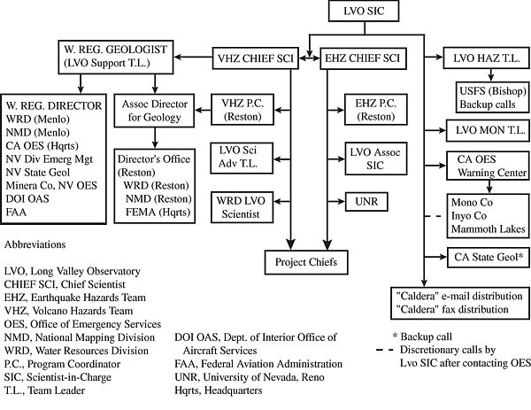
Figure 5. U.S. Geological Survey (USGS) calldown structure for an EVENT RESPONSE (conditions YELLOW, ORANGE, or RED).
If, upon evaluation of the data and consultation with USGS scientific and management personnel, the LVO SIC concludes that the activity warrants a condition YELLOW, the SIC, in consultation with the Volcano Hazards Team Chief Scientist, will recommend that the Western Regional Geologist (or designated deputy), declare EVENT RESPONSE conditions. Such a declaration will activate the establishment of a field center (fig. 4). USGS, local, state, and Federal officials will be notified of this decision through the full calldown procedure (see fig. 5 and item 6 below).
If, upon evaluation of the data and consultation with USGS scientific and management personnel, the LVO SIC concludes that the activity strongly suggests that an eruption is likely to occur within hours to a few days, the LVO SIC will, with the concurrence of the Western Regional Geologist (or designated deputy), declare a condition ORANGE and recommend that the Director issue a GEOLOGIC HAZARD WARNING of a possible imminent volcanic eruption. If a condition YELLOW is not already in effect, the condition ORANGE will also trigger an EVENT RESPONSE. Depending on the location of the escalating unrest and the likely site for the eruption outbreak, the LVO SIC may, in the interest of personnel safety and continuity of monitoring activities, move the fieldoperations center from Mammoth Lakes to Bridgeport (see item 7 below).
With the onset of eruptive activity an EVENT RESPONSE previously established under condition YELLOW or ORANGE will continue, and the GEOLOGIC HAZARD WARNING issued under condition ORANGE will be updated as frequently as needed depending on eruptive activity. In the unlikely event that an eruption should begin with little or no prior warning such that neither conditions YELLOW and ORANGE are in effect, a condition RED will immediately trigger both an EVENT RESPONSE and release of a GEOLOGIC HAZARD WARNING.
Either in advance of, or upon, declaration of EVENT RESPONSE conditions, the Western Regional Geologist, or the LVO SIC, will make arrangements for the assignment of appropriate personnel and other resources from all USGS units. Once these resources are secured, the LVO SIC has the full authority for assignment of EVENT RESPONSE personnel. Normally, the SIC's requests for personnel or equipment will be discussed with, and relayed through, the appropriate supervisor, who must make every effort to supply the resources requested. In the event that a supervisor is not available, the SIC may contact and assign individuals directly. Should a EVENT RESPONSE situation occur simultaneously with heightened activity elsewhere, conflicting demands for personnel and resources will be resolved, if necessary, by the Western Regional Geologist. Once assigned to an EVENT RESPONSE team, all personnel and equipment fall under the authority of the EVENT RESPONSE structure until released by the LVO SIC or the Western Regional Geologist.
Upon declaration of EVENT RESPONSE (conditions YELLOW and above) by the Western Regional Geologist, the LVO SIC will establish a field center for LVO operations in the USGS Field Center in Mammoth Lakes and a backup field office in the Mono County Sheriff's Office in Bridgeport (fig. 4). Deployment of personnel and material to the field centers will be on instructions of the LVO SIC to project personnel, either directly or through appropriate managers. Under usual circumstances (for example, there are no volcanic or seismic crises elsewhere requiring USGS response), the primary field center in Mammoth Lakes will be initially manned by personnel from the USGS Center in Menlo Park and the backup field office in Bridgeport will be initially manned by personnel from the USGS Cascades Volcano Observatory (CVO) in Vancouver, Washington. The LVO SIC must make every effort to see that the primary field center (whether in Mammoth Lakes or Bridgeport) is staffed with sufficient personnel to maintain an effective 24-hour operation. To the extent feasible, the backup field center will duplicate the monitoring and communication capabilities of the primary field office in Mammoth Lakes to insure uninterrupted monitoring of the evolving crisis. Depending on circumstances, the LVO SIC will also appoint (1) a Deputy SIC (DSIC) to serve as his/her alternate during scheduled shifts in a 24-hour watch maintained at the LVO field office, and (2) a second DSIC to oversee operations at the backup field office in Bridgeport (fig. 4). Depending on personnel available, the DSIC positions may be assigned as full-time responsibilities for specific individuals or they may be assigned as part of the responsibilities for the Hazards or Monitoring Team Leaders.
Under most circumstances, the USGS field center in Mammoth Lakes will be the primary field center for USGS operations and communications during an EVENT RESPONSE (see item 7 below). Regardless, the primary active field office will serve as (1) a communications center for USGS field operations, (2) a staging center for all monitoring, scientific, hazards assessment, and support activities, and (3) an information center for local, state, and Federal officials. The DSIC at the primary active field center (whether Mammoth Lakes or Bridgport) will have authority over any other DISCs.
Once EVENT RESPONSE conditions have been declared, each person or field party must contact the appropriate Team Leader prior to beginning field activities in the LVC/MC region to (1) inform the Team Leader of their field plans, such as where they will be staying, and (2) receive last minute information on logistics and special arrangements. When operating under EVENT RESPONSE conditions, radio contact is to be maintained with the field center at all times while in the field, and field personnel must be prepared to respond directly to requests and instructions from either the Team Leaders or the SIC concerning monitoring efforts, hazard assessment, data reporting, safety precautions, and other matters. In addition, one or more representatives from each field party must participate in any coordination or data-evaluation meetings called by the SIC or the respective Team Leaders.
The short-term hazard assessment of an impending or in-progress volcanic eruption will depend almost exclusively on the quality and timeliness of data generated by the various monitoring efforts and observations of eruptive activity, and on the ability of personnel to review promptly all scientific data as they are obtained. Therefore, it is essential that the data from each monitoring activity (including on-site eruption documentation) be transmitted through the Monitoring Team Leader to the SIC and the Hazards Assessment Team Leader as quickly and accurately as possible. While responding to heightened activity, the focus of all monitoring and eruption-documentation activities must be on the current situation and how it is changing. Everyone involved in monitoring efforts and field observations should bear in mind that their own personal safety, as well as that of their colleagues and the public, may depend on how quickly their data are collected, processed, transmitted, and analyzed in conjunction with the data produced by their coworkers.
If intense unrest or volcanic activity makes it prudent to abandon the Mammoth Lakes field office as a field center, the LVO SIC will pass authority for LVO operations to the DSIC in the backup office located in the Mono County Sheriff's Office in Bridgeport. The decision to change field centers is the responsibility of the SIC; time permitting, the SIC will consult with the TCS. Specific instructions for change of centers will be issued by radio to all field parties at that time.
Deactivation of the LVO Field Center will be determined and announced by the LVO SIC in consultation with the TCS, the Western Regional Geologist, and the three Team Leaders. Normally, deactivation will coincide with the termination of a condition YELLOW (see table 3). Personnel must not cease operating from the field center without first notifying their respective Team Leader of their intentions and receiving his or her permission to cease operations.
In the case of an EVENT RESPONSE, the Western Regional Hydrologist, Cartographer, and Biologist will arrange to have members of their respective disciplines, along with any necessary equipment, assigned to the Event Response Team as appropriate. Once assigned to the Event Response Team, they will be under the supervision of the LVO SIC.
Should a situation develop
in which assessment of hydrologic hazards becomes a significant component of
the Event Response, the Western Regional Hydrologist will arrange to have a
high-level scientist assigned to the LVO SIC's immediate staff. This individual
will have the responsibility for advising the SIC on potential hydrologic hazards
of the situation at hand and the appropriate response. This individual will
work with the SIC and assume supervision of the hydrologic group within the
Event Response Team as delegated by the SIC. Regardless, the final responsibility
for the USGS response will rest with the LVO SIC.
Aoki, Y., Segall, P., Kato, T., Cervelli, P., and Shimada, S., 1999, Imaging magma transport during the 1997 seismic swarm off the Izu Peninsula, Japan: Science, v. 286, p. 927-930.
Bailey, R.A., 1989, Geologic map of Long Valley Caldera, Mono Inyo Craters volcanic chain, and vicinity, eastern California, U.S. Geological Survey Miscellaneous Investigations Series I-1933, 1:62,500, p. 11.
Bailey, R.A., 1990, Magmatic unrest at Long Valley Caldera, California, 1980-1990 [abs]: Geological Association of Canada, Abstracts with Program, v. 15, p. 6.
Bailey, R.A., Dalrymple, G.B., and Lanphere, M.A., 1976, Volcanism, structure, and geochronology of Long Valley Caldera, Mono County, California: Journal of Geophysical Research, v. 81, no. 5, p. 725-744.
Bailey, R.A., and Hill, D.P., 1990, Magmatic unrest at Long Valley Caldera, California, 1980-1990: Geoscience Canada, v. 17, no. 3, p. 175-179.
Bakun, W.K., Breckenridge, K.S., Bredehoeft, J., Burford, R.O., Ellswroth, W.L., Johnston, M.J.S., Jones, L., Lindh, A.G., Mortensen, C., Mueller, R.J., Poley, C.M., Roeloffs, E., Schulz, S., Segall, P., and Thatcher, W., 1987, Parkfield, California, earthquake prediction scenarios and response plans: U.S. Geological Survey 87-192.
Battaglia, M., Roberts, C., and Segall, P., 1999, Magma intrusion beneath Long Valley Caldera confirmed by temporal changes in gravity: Science, v. 285, no. 5436, p. 2119-2122.
Behr, J., Bilham, R., and Beavan, J., 1992, Monitoring of magma chamber inflation using a biaxial Michelson tiltmeter in Long Valley Caldera, California [abs]: Eos, Transactions, American Geophysical Union, v. 73, no. 43, p. 347-348.
Benioff, H., 1951,
Earthquakes and rock creep, Part I: Bulletin of the Seismological Society of
America, v. 41, p. 31-62.
Blong, R., and McKee, C., 1995, The Rabaul Eruption 1994: Macquarie University,
NSW 2109 Australia, Natural Hazards Research Center, 52 p.
Bursik, M.I., and Sieh, K.E., 1986, Late Quaternary faulting in Mono Basin, east central California [abs]: Geological Society of America, Abstracts with Programs, v. 18, no. 2, p. 91.
Castle, R.O., Estrem, J.E., and Savage, J.C., 1984, Uplift across Long Valley Caldera, California: Journal of Geophysical Research, v. 89, no. 13, p. 11,507-11,516.
Chouet, B., 1992, A seismic model for the source of long-period events and harmonic tremor, in Gasparini, P., Scarpa, R., and Aki, K., eds., Volcanic Seismology (3 ed.): IAVCEI Proceedings in Volcanology: Berlin, Heidelberg, New York, Springer-Verlag, p. 133-156.
Chouet, B., 1996, New methods and future trends in seismological volcano monitoring, in Scarpa, R., and Tilling, R.I., eds., Monitoring and Mitigation of Volcano Hazards: Berlin, Heidelberg, Springer-Verlag, p. 23-97.
Chouet, B., and Julian, B.R., 1985, Dynamics of an expanding fluid filled crack: Journal of Geophysical Research, v. 90, no. 13, p. 11,187-11,198.
Chouet, B.A., 1991, A seismic model for the source of long-period events and harmonic tremor, in Gasparini, P., Scarpa, R., and Aki, K., eds., Volcanic Seismology: IAVCEI Proceedings in Volcanology: Berlin, Springer-Verlag, p. 133-156.
Chouet, B.A., Dawson, P., and Kedar, S., 1998, Waveform inversion of very long period impulsive signals associated with magmatic injection beneath Kilauea Volcano, Hawaii: Journal of Geophysical Research, v. 103, p. 23,839-23,862.
Cockerham, R.S., and Corbett, E.J., 1987, The 1986 Chalfant Valley, California, earthquake sequence: preliminary results: Bulletin of the Seismological Society of America, v. 77, no. 1, p. 280-289.
Cramer, C.H., and McNutt, S.R., 1997, Spectral analysis of earthquakes in the 1989 Mammoth Mountain swarm near Long Valley, California: Bulletin of the Seismological Society of America, v. 87, no. 6, p. 1454-1462.
Cramer, C.H., and Toppozada, T.R., 1980, A seismological study of the May, 1980, and earlier earthquake activity near Mammoth Lakes, California, in Sherburne, R.W., ed., Mammoth Lakes, California earthquakes of May 1980, California Division of Mines and Geology Special Report 150, p. 91-122.
Decker, R.W., 1986, Forecasting volcanic eruptions: Annual Review of Earth and Planetary Sciences, v. 14, p. 267-291.
Dewey, J.W., Hill, D.P., Ellsworth, W.L., and Engdahl, E.R., 1989, Earthquakes, faults, and the seismotectonic framework of the contiguous United States, in Paksier, L.C., and Mooney, W.D., eds., Geophysical Framework of the Continental United States: Boulder, Colorado, Geological Society of America, p. 541-575.
Dreger, D.S., Tkalcic, H., and Johnston, M., 2000, Dilational process accompanying earthquakes in the Long Valley Caldera: Science, v. 288, no. 5463, p. 122-125.
Dvorak, J.J., and
Gasparini, P., 1991, History of earthquakes and vertical ground movement in
Campi Flegrei caldera, southern Italy: comparison of precursory event to the
A.D. eruption of Monte Nuovo and activity since 1986: Journal of
Volcanology and Geothermal Research, v. 48, no. 1/2, p. 77-92.
Ewert, J.W., and Harpel, C.J., 2000, Bibliography and literature pertaining to Long Valley Caldera and associated volcanic fields: U.S. Geological Survey Open-File Report 00-221, v 1.0, https://pubs.usgs.gov/of/2000/of00-221.
Farrar, C.D., Sorey, M.L., Evans, W.C., Howle, J.F., Kerr, B.D., Kennedy, B.M., King, C.-Y., and Southon, J.R., 1995, Forest-killing diffuse CO2 emission at Mammoth Mountain as a sign of magmatic unrest: Nature, v. 376, no. 6542, p. 675-678.
Galloway, D., Farrar, C.D., Howle, J.F., Roeloffs, E.A., Sneed, M., and Sorey, M.L., 1999, Hydrologic response to the 1997-period of crustal unrest at Long Valley Caldera, California [abs]: Eos, Transactions, American Geophysical Union, v. 80, no. 46, p. 981.
Gerlach, T.M., Doukas, M.P., McGee, K.A., and Kessler, R., 1999, Airborne detection of diffuse carbon dioxide emissions at Mammoth Mountain, California: Geophysical Research Letters, v. 26, no. 24, p. 3661-3664.
Gerlach, T.M., Westrich, H.R., and Symonds, R.B., 1996, Preeruption vapor in magma of the climactic Mount Pinatubo eruption: source of the giant stratospehric sulfur dioxide cloud, in Newhall, C.G., and Punongbayan, R.S., eds., Fire and Mud: Seattle, University of Washington Press, p. 415-433.
Gudmundsson, M.T., Sigmundsson, F., and Bjornsson, H., 1997, Ice-volcano interaction of the 1996 Gjalp subglacial eruption, Vatnajokull, Iceland: Nature, v. 389, p. 954-957.
Hanks, T.C., and Kanamori, H., 1979, A moment magnitude scale: Journal of Geophysical Research, v. 84, no. B5, p. 2348-2350.
Hasegawa, A., Zhao, D., Hori, S., Yamamoto, A., and Houruchi, S., 1991, Deep structure of the northeastern Japan arc and its relationship to seismic and volcanic activity: Nature, v. 352, p. 683-689.
Hill, D.P., 1984, Monitoring unrest in a large silicic caldera, the Long Valley Inyo Craters volcanic complex in east central California: Bulletin Volcanologique, v. 47, no. 2, p. 371-395.
Hill, D.P., 1992, Temperatures at the base of the seismogenic crust beneath Long Valley Caldera, California, and the Phlegrean Fields caldera, Italy, in Johnson, R.W., Mahood, G.A., and Scarpa, R., eds., Volcanic Seismology: New York, Springer-Verlag, p. 432-461.
Hill, D.P., 1996, Earthquakes and carbon dioxide beneath Mammoth Mountain, California: Seismological Research Letters, v. 67, no. 1, p. 8-15.
Hill, D.P., 1998, 1998 Seismological Society of America Meeting-Presidential Address: Science, geologic hazards, and the public in a large restless caldera: Seismological Research Letters, v. 69, no. 5, p. 400-404.
Hill, D.P., Bailey, R.A., and Ryall, A.S., 1985, Active tectonic and magmatic processes beneath Long Valley Caldera, eastern California; an overview: Journal of Geophysical Research, v. 90, no. 13, p. 11,111-11,120.
Hill, D.P., Ellsworth, W.L., Johnston, M.J.S., Langbein, J.O., Oppenheimer, D.H., Pitt, A.M., Reasenberg, P.A., Sorey, M.L., and McNutt, S.R., 1990, The 1989 earthquake swarm beneath Mammoth Mountain, California; an initial look at the 4 May through 30 September activity: Bulletin of the Seismological Society of America, v. 80, no. 2, p. 325-339.
Hill, D.P., Johnston, M.J.S., Langbein, J.O., and Bilham, R., 1995, Response of Long Valley Caldera to the Mw = 7.3 Landers, California, earthquake: Journal of Geophysical Research, v. 100, no. B7, p. 12,985-13,005.
Hill, D.P., Johnston, M.J.S., Langbein, J.O., McNutt, S.R., Miller, C.D., Mortensen, C.E., Pitt, A.M., and Rojstaczer, S.A., 1991, Response plans for volcanic hazards in the Long Valley Caldera and Mono Craters area, California, U.S. Geological Survey Open-File Report 91-270, p. 65.
Hill, D.P., Reasenberg, P.A., Michael, A., Arabaz, W.J., Beroza, G., Brumbaugh, D., Brune, J.N., Castro, R., Davis, S., dePolo, D., Ellsworth, W.L., Gomberg, J., Harmsen, S., House, L., Jackson, S.M., Johnston, M.J.S., Jones, L., Keller, R., Malone, S.,Munguia, L., Nava, S., Pechmann, J.C., Sanford, A., Simpson, R.W., Smith, R.B., Stark, M., Stickney, M., Vidal, A., Walter, S., Wong, V., and Zollweg, J., 1993, Seismicity remotely triggered by the magnitude 7.3 Landers, California, earthquake: Science, v. 260, p. 1617-1623.
Hill, D.P., Wallace, R.E., and Cockerham, R.S., 1985, Review of evidence on the potential for major earthquakes and volcanism in the Long Valley-Mono Craters-White Mountains regions of eastern California: Earthquake Prediction Research, v. 3, no. 3-4, p. 571-594.
Hough, S.E., Dollar, R.S., and Johnson, P., 2000, The 1998 earthquake sequence south of Long Valley Caldera, California: hints of magmatic involvement: Bulletin of the Seismological Society of America, v. 90 p.
Howle, J.F., and Farrar, C.D., 1996, Hydrologic data for Long Valley Caldera, Mono County, California, 1978-93, U.S. Geological Survey Open-File Report 96-382, p. 286.
Johnston, M.J.S., 1989, Review of magnetic and electric field effects near active faults and volcanoes in the U.S.A.: Physics of the Earth and Planetary Interiors, v. 57, no. 1-2, p. 47-63.
Johnston, M.J.S., Hill, D.P., Linde, A.T., Langbein, J., and Bilham, R., 1995, Transient deformation during triggered seismicity from the 28 June 1992 Mw=7.3 Landers earthquake at Long Valley volcanic caldera, California: Bulletin of the Seismological Society of America, v. 85, no. 3, p. 787-795.
Julian, B.R., 1983, Evidence for dyke intrusion earthquake mechanisms near Long Valley Caldera, California: Nature, v. 303, no. 5915, p. 323-325.
Julian, B.R., 1994, Volcanic tremor: nonlinear excitation by fluid flow: Journal of Geophysical Research, v. 99, no. B6, p. 11,859-11,877.
Julian, B.R., Miller, A.D., and Foulger, G.R., 1998, Non-double-couple earthquakes: 1. Theory: Reviews of Geophysics, v. 36, no. 4, p. 525-549.
Julian, B.R., and Sipkin, S.A., 1985, Earthquake processes in the Long Valley Caldera area, California: Journal of Geophysical Research, v. 90, no. B13, p. 11,155-11,169.
Kaneshima, S., Kawakatsu, H., Matsubayashi, H., Sudo, Y., Tsutsui, T., Ohminato, T., Ito, H., Uhira, K., Yamasato, H., Oikawa, J., Takeo, M., and Iidaka, T., 1996, Mechanism of phreatic eruptions at Aso Volcano inferred from near-field broadband seismic observations: Science, v. 273, p. 642-645.
Lajoie, K.R., 1968, Late Quaternary stratigraphy and geologic history of Mono Basin, eastern California, University of California, Berkley, Ph.D., 271 p.
Langbein, J.O., 1989, Deformation of the Long Valley Caldera, eastern California, from mid-1983 to mid-1988; measurements using a two-color geodimeter: Journal of Geophysical Research, v. 94, no. B4, p. 3833-3849.
Langbein, J.O., Dzurisin,
D., Marshall, G., Stein, R., and Rundle, J., 1995, Shallow and peripheral volcanic
sources of inflation revealed by modeling two-color geodimeter and leveling
data from Long Valley Caldera, California, 1988-1992:
Journal of Geophysical Research, v. 100, no. B7, p. 12,487-12,496.
Langbein, J.O., Hill, D.P., Parker, T.N., Wilkinson, S.E., and Pitt, A.M., 1990, Renewed inflation of the resurgent dome in Long Valley Caldera, California, from mid-1989 to mid-1990 [abs]: Eos, Transactions, American Geophysical Union, v. 71, no. 43, p. 1466.
Langbein, J.O., Hill, D.P., Parker, T.N., and Wilkinson, S.K., 1993, An episode of reinflation of the Long Valley Caldera, eastern California: 1989-1991: Journal of Geophysical Research, v. 98, no. B9, p. 15,851-15,870.
Langbein, J.O., and Johnson, H., 1997, Correlated errors in geodetic time series; implications for time-dependent deformation: Journal of Geophysical Research, v. 102, no. B1, p. 591-604.
Mader, G.G., Blair, M.L., and Olson, R.A., 1987, Living with a volcanic threat; response to volcanic hazards, Long Valley, California: Portola Valley, CA, William Spangle and Associates, 105 p.
Malin, P., Stroujkova, A., and Shalev, E., 1998, A seismological witness to the birth of a dike: micro- hybred- and low-frequence earthquake activity at Mammoth, CA, in 1997 [abs.]: EOS, Transactions, AGU, v. 79, no. 45, p. F949.
Marshall, G.A., Langbein, J., Stein, R.S., Lisowski, M., and Svarc, J., 1997, Inflation of Long Valley Caldera, California, Basin and Range strain, and possible Mono Craters' dike opening from 1990 to 1994 GPS surveys: Geophysical Research Letters, v. 24, no. 9, p. 1003-1006.
McClelland, L., Simkin, T., Summers, M., Nielsen, E., and Stein, T.C., eds., 1989, Global Volcanism 1975-1985: Englewood cliffs, New Jersey, Prentice Hall, 655 p.
McGee, K.A., and Gerlach, T.M., 1998, Annual cycle of magmatic CO2 in a tree-kill soil at Mammoth Mountain, California; implications for soil acidification: Geology, v. 26, no. 5, p. 463-466.
McNutt, S.R., 2000, Volcanic seismicity, in Sigurdsson, H., ed., Encyclopedia of Volcanology: San Diego, San Francisco, Academic Press, p. 1,015-1,033.
McNutt, S.R., Rymer, H., and Stix, J., 2000, Synthesis of volcano monitoring, in Sigurdsson, H., ed., Encyclopedia of Volcanology: San Diego, Academic Press, p. 1165-1183.
Miller, A.D., Foulger, G.R., and Julian, B.R., 1998, Non-double-couple earthquakes: 2. Observations: Reviews of Geophysics, v. 36, no. 4, p. 551-568.
Miller, C.D., 1985, Holocene eruptions at the Inyo volcanic chain, California; implications for possible eruptions in Long Valley Caldera: Geology, v. 13, no. 1, p. 14-17.
Miller, C.D., 1989, Potential hazards from future eruptions in California, U.S. Geological Survey Bulletin 1847, p. 17.
Miller, C.D., Mullineaux, D.R., Crandell, D.R., and Bailey, R.A., 1982, Potential hazards from future volcanic eruptions in the Long Valley Mono Lake area, east central California and southwest Nevada; a preliminary assessment, U.S. Geological Survey Circular 877, p. 10.
Mortensen, C.E., and Hopkins, D.G., 1987, Tiltmeter measurements in Long Valley Caldera, California: Journal of Geophysical Research, v. 92, no. 13, p. 13,767-13,776.
Mueller, R.J., Johnston, M.J.S., and Langbein, J.O., 1991, Possible tectonomagnetic effect observed from mid-1989, to mid-1990, in Long Valley Caldera, California: Geophysical Research Letters, v. 18, no. 4, p. 601-604.
Murray, T., and Endo, E.T., 1989, A real-time seismic amplitude measurement system (RSAM): U.S. Geological Survey 89-684.
Newhall, C.G., 2000, Volcano Warnings, in Sigurdsson, H., ed., Encyclopedia of Volcanoes: San Diego, Academic Press, p. 1185-1197.
Newhall, C.G., and Dzurisin, D., 1988, Historical unrest at large calderas of the world, U.S. Geological Survey Bulletin 1855, p. 1108.
Newhall, C.G., and Self, S., 1982, The volcanic explosivity index (VEI): An estimate of explosive magnitude for historical volcanism: Journal of Geophysical Research, v. 87, p. 1,231-1,238.
Ohiminato, T., Chouet, B.A., Dawson, P.B., and Kedar, S., 1998, Waveform inversion of very-long-period impulsive signals associated with magmatic injection beneath Kilauea volcano, Hawaii: Journal of Geophysical Research, v. 103, p. 23,839-23,862.
Okada, Y., and Yamamoto, E., 1991, Dyke intrusion for the 1989 seismo-volcanic activity off Ito, central Japan: Journal of Geophysical Research, v. 96, p. 10,361-10,376.
Pitt, A.M., and Hill, D.P., 1994, Long-period earthquakes in the Long Valley Caldera region, eastern California: Geophysical Research Letters, v. 21, no. 16, p. 1679-1682.
Prejean, S.G., Ellsworth, W.L., Waldhouser, F., and Zoback, M.D., 2000, Earthquake relocations and stress inversions in the Long Valley Caldera, California [abs.]: EOS, Transactions, American Geophysical Union, v. 81, no. 48, p. F1323.
Priestley, K.F., Smith, K.D., and Cockerham, R.S., 1988, The 1984 Round Valley, California earthquake sequence: Geophysical Journal of the Royal Astronomical Society, v. 95, no. 2, p. 215-235.
Rojstaczer, S., Sorey, M.L., Farrar, C.D., and Clark, M.D., 1985, Water wells as strain meters during 1984 within the Long Valley Caldera [abs.]: Eos, Transactions, American Geophysical Union, v. 66, no. 18, p. 363.
Rosi, M., and Santacroce, R., 1984, Volcanic hazard assessment in the Phlegrean Fields-A contribution based on stratigraphic and historical data: Bulletin Volcanologique, v. 47, no. 2, p. 359-370.
Rundle, J.B., and Hill, D.P., 1988, The geophysics of a restless caldera; Long Valley, California: Annual Review of Earth and Planetary Sciences, v. 16, p. 251-271.
Ryall, A.S., Jr., and Ryall, F., 1980, Spatial-temporal variations in the seismicity preceding the May, 1980, Mammoth Lakes, California, earthquakes, in Sherburne, R.W., ed., Mammoth Lakes, California earthquakes of May 1980, California Division of Mines and Geology Special Report 150, p. 27-39.
Ryall, A.S., Jr., and Ryall, F., 1983, Spasmodic tremor and possible magma injection in Long Valley Caldera, eastern California: Science, v. 219, no. 4591, p. 1432-1433.
Savage, J.C., 1988, Principal component analysis of geodetically measured deformation in Long Valley Caldera, eastern California, 1983-1987: Journal of Geophysical Research, v. 93, no. B11, p. 13,297-13,305.
Savage, J.C., and Clark, M.M., 1982, Magmatic resurgence in Long Valley Caldera, California; possible cause of the 1980 Mammoth Lakes earthquakes: Science, v. 217, no. 4559, p. 531-533.
Savage, J.C., Cockerham, R., S., Estrem, J.E., and Moore, L.R., 1987, Deformation near the Long Valley Caldera, eastern California, 1982-1986: Journal of Geophysical Research, v. 92, no. 3, p. 2721-2746.
Savage, J.C., and Cockerham, R.S., 1984, Earthquake swarm in Long Valley Caldera, California, January 1983; evidence for dike inflation: Journal of Geophysical Research, v. 89, no. 10, p. 8315-8324.
Shimozuru, D., and Kagiyama, T., 1989, Some significant features of pre-eruption volcanic earthquakes, in Latter, J.H., ed., Volcanic Hazards: Berlin, Heidelberg, Springer-Verlag, p. 504-512.
Smith, K.D., and Priestley, K.F., 1988, The foreshock sequence of the 1986 Chalfant, California, earthquake: Bulletin of the Seismological Society of America, v. 78, no. 1, p. 172-187.
Sorey, M.L., Evans, W.C., Kennedy, B.M., Farrar, C.D., Hainsworth, L.J., and Hausback, B., 1998, Carbon dioxide and helium emissions from a reservoir of magmatic gas beneath Mammoth Mountain, California: Journal of Geophysical Research, v. 103, no. B7, p. 15,303-15,323.
Stine, S.W., 1987,
Mono Lake; the past 4,000 years: University of California, Berkeley, Ph.D. dissertation,
732 p.
Takeo, M., 1990, Analysis of Long-period seismic waves excited by the November
1987 eruption of Izu-Oshima Volcano: Journal of Geophysical Research, v. 95,
p. 19,377-19,393.
Tilling, R.I., 1995, The role of monitoring in forecasting volcanic events, in McGuire, B., Kilburn, C.R., and Murray, J., eds., Monitoring Active Volcanoes: London, UCL Press, p. 369-402.
U.S. Geological Survey, 1984, USGS Response Plan for Volcanic Hazards in the Long Valley Caldera - Mono Craters Area, California: U.S. Geological Survey 84-500.
Van Wormer, J.D., and Ryall, A.S., 1980, Sierra Nevada-Great Basin boundary zone: earthquake hazards related to structure, active tectonic processes, and anomalous patterns of earthquake occurrence: Bulletin of the Seismological Society of America, v. 70, p. 1557-1572.
Wallace, T.C., Given, J., and Kanamori, H., 1982, A discrepancy between long and short period mechanisms of earthquakes near the Long Valley Caldera: Geophysical Research Letters, v. 9, no. 10, p. 1131-1134.
Young, S.R., Francis, P.W., Barclay, J., Casadevall, T.J., Gardner, C.A., Darroux, B., Davies, M.A., Delmelle, P., Norton, G.E., Maciejewski, A.J.H., Oppenheimer, C.M.M., Stix, J., and Watson, I.M., 1998, Monitoring SO2 emission at the Soufriere Hills volcano: Implications for changes in eruptive conditions: Geophysical Research Letters, v. 25, no. 19, p. 3681-3684.