![]()
|| Surface water || Ground water ||
|
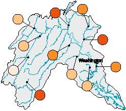
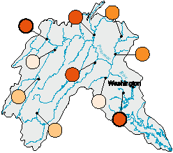
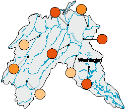
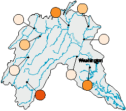
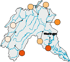
Seven major water-quality characteristics were evaluated for selected stream sites in each NAWQA Study Unit. Summary scores for each characteristic were computed for all sites that had adequate data. Scores for each routine monitoring site in the Potomac River Basin (fig. 29) were compared with scores for all sites sampled in the 20 NAWQA Study Units during 1992-95. Results are summarized by percentiles; higher percentile values generally indicate poorer quality compared with other NAWQA sites. Water-quality conditions at each site also are compared to established criteria for protection of aquatic life. Applicable criteria are limited to nutrients and pesticides in water, and semivolatile organic compounds, organochlorine pesticides, and PCBs in sediment. (Methods used to compute rankings and evaluate aquatic-life criteria are described by Gilliom and others, in press.) |
|
EXPLANATION Ranking of stream quality relative to all NAWQA stream sites-- Darker colored circles generally indicate poorer quality. Bold outline of circle indicates one or more aquatic life criteria were exceeded.
|
NUTRIENTS in water | |
|---|---|
|
Among sites at which long-term data were collected, nutrient concentrations in the Potomac River Basin were consistently highest in streams draining mostly agricultural areas, particularly in Conococheague and Muddy Creeks and the Shenandoah River, which drain areas underlain by carbonate rocks. Nutrient concentrations in these streams and the Monocacy River ranked among the highest in the Nation, although no applicable criteria for the protection of aquatic life were exceeded. |
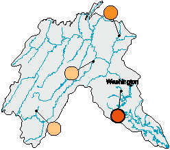
PESTICIDES in water | |
|
Accotink Creek, which drains a small urban basin near Washington, D.C., had the highest concentrations of pesticides measured in the Potomac River Basin and ranked among the highest observed, nationwide. Agricultural basins (particularly cropped) also contribute relatively large amounts of pesticides to the Potomac River, but less so than Accotink Creek. Concentrations of pesticides at these sites are similar to many sites across the Nation. Similar concentrations of herbicides were detected among agricultural and urban sites, but insecticide concentrations were higher at the urban site. Aquatic-life criteria were exceeded only in Accotink Creek. |
ORGANOCHLORINE PESTICIDES and PCBs in streambed sediment and aquatic tissues | |
|
PCBs or organochlorine pesticides were detected in streambed sediment or aquatic tissues at all sampled sites and the levels of these compounds at four sites rank among the highest in the Nation. Chlordane concentrations in streambed sediment at sites on the North Branch Potomac River and Accotink Creek exceeded threshold levels that indicate a potential to cause adverse effects on aquatic organisms. Further sampling would be necessary to determine possible dangers of consuming fish from these sites (for more information, see pages 16-19). |
TRACE ELEMENTS in streambed sediment | |
|
Trace element concentrations in streambed sediment were among highest in the Nation at two of ten sampled sites in the Potomac River Basin. Relatively high concentrations of mercury and zinc were detected in the North Branch Potomac River at Cumberland, Md. This site drains a coal-mining region as well as nearby urban and industrial land. Mercury concentrations in the Shenandoah River at Millville, W. Va., were greater than seven times the National median (for more information, see page 18). |
SEMIVOLATILE ORGANIC COMPOUNDS in streambed sediment | |
|
Concentrations of semivolatile organic compounds (SVOCs) in streambed sediment were among the highest in the Nation at four sites in the Potomac River Basin. Two of these sites are near urban areas and the others, the Shenandoah River and Conococheague Creek, drain mixed urban and agricultural areas. Criteria for the protection of aquatic life were not exceeded. |
FISH COMMUNITY DEGRADATION | |
|
Of nine sites in the Potomac River Basin at which fish communities were analyzed, only Muddy Creek, in an agricultural setting, was highly degraded relative to sites nationwide. A high percentage of fish found at this site are pollution tolerant. Fish communities at two other sites were degraded to a lesser degree but were also among the most degraded in the Nation. One of these sites, Conococheague Creek, drains an agricultural area and the other, Accotink Creek, drains an urban area near Washington, D.C. |
STREAM HABITAT DEGRADATION | |
| Stream habitats at Muddy and Accotink Creeks were among the most degraded in the Nation. A majority of sites in the Potomac River Basin at which stream habitats were assessed exhibited moderate to high habitat degradation with typically lower bank stability, increased bank erosion, and lower densities of riparian vegetation than at less degraded sites. |
|| Surface water || Ground water ||