
INTRODUCTION TO THE UPPER TENNESSEE RIVER BASIN
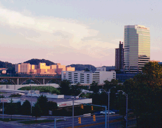
The Upper Tennessee River Basin Study Unit encompasses about 21,390 square miles and includes the entire drainage area of the Tennessee River and its tributaries upstream from the USGS gaging station at Chattanooga, Tennessee. The study area includes parts of four States: Tennessee (11,500 square miles), North Carolina (5,480 square miles), Virginia (3,130 square miles), and Georgia (1,280 square miles). In 1990, the total population of the study area was about 2.4 million, of which about 1.6 million resided in the four metropolitan statistical areas of Chattanooga and Knoxville, Tennessee; Asheville, North Carolina; and the Tri-Cities area of Kingsport and Johnson City, Tennessee, and Bristol, Tennessee and Virginia.
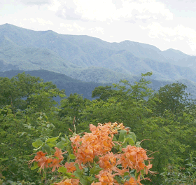
Parts of three physiographic provincesthe Cumberland Plateau, Valley and Ridge, and Blue Ridge Provinces compose the Upper Tennessee River Basin. Altitudes range from 621 feet above sea level at Chattanooga to 6,684 feet at Mount Mitchell, which is just northeast of Asheville, North Carolina, and is the highest point in the Eastern United States. The Study Unit contains some of the most rugged terrain in the Eastern United States, including the Great Smoky Mountains range. The crest of the Smoky Mountains exceeds 5,000 feet for 34 miles along the Tennessee-North Carolina State line, has 16 peaks that exceed 6,000 feet, and is the most massive mountain range east of the Mississippi River.
The region generally has a temperate climate; temperatures and annual precipitation totals largely are dependent on land-surface elevations. Average annual temperatures in the area generally decrease by about 3 degrees Fahrenheit for every 1,000-foot increase in elevation. Average annual precipitation ranges from about 40 inches in some low-lying, sheltered areas in the Valley and Ridge province to more than 90 inches at elevations over 6,000 feet. Precipitation generally is distributed evenly throughout the year with no distinct dry and wet seasons.(1)
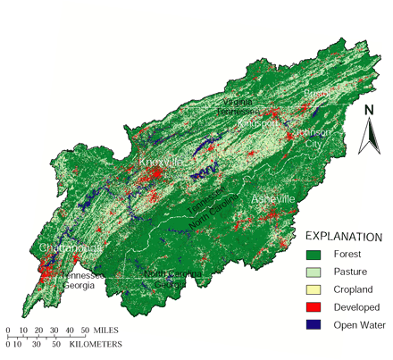
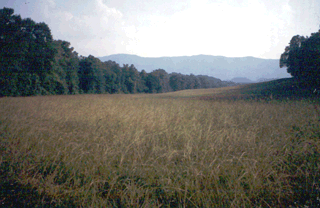
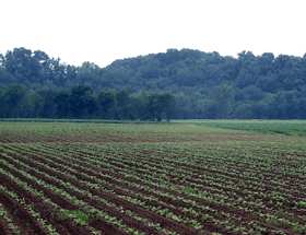
Forests cover more than 67 percent of the Study Unit (fig. 1) and five National ForestsJefferson, Pisgah, Cherokee, Nantahala, and Chattahooche National Forestswholly or partially lie within the basin. Agricultural land, predominantly pasture, is the second most common land use and accounts for more than 26 percent of the study area. Row crops account for only about 2.6 percent of the study area. Most of the agricultural land is located in the stream valleys and gently rolling parts of the Valley and Ridge physiographic province. The crests of steep ridges and more rugged areas of the basin remain forested. Less than 4.5 percent of the basin is developed. Row crops and developed areas, however, generally affect water-quality conditions much more than their small percentages would indicate.
 |
|
 |
 |
| Forest is the predominant land use in the Upper Tennessee River Basin | Pasture is the predominant agricultural land use in the Upper Tennessee Basin. |
 |
 |
| Row crops account for only 2.6 percent of the Upper Tennessee River Basin. | Urban and industrial land uses have greater water-quality effects than their land-use percentages might indicate. |
| Figure 1. Water-quality conditions in the Upper Tennessee River Basin are influenced by land uses. | |
 |
|
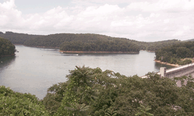
| Large reservoirs are the most prominent surface water features of the Upper Tennessee Basin. |
Surface-Water Features
The most prominent surface-water features of the Upper
Tennessee River Basin are the tributary and main-stem reservoirs constructed
and maintained by the Tennessee Valley Authority (TVA) and sometimes referred
to as the Great Lakes of the South. Four main-stem reservoirs are primarily
flow-through systems that provide power generation and maintain navigational
depths but provide little flood storage. These four reservoirs have a
combined capacity of about 3.1 million acre-feet. Seventeen tributary
reservoirs provide flood storage and power generation. These tributary
reservoirs have a combined storage capacity of some 10 million acre-feet.
An additional 17 privately owned and operated reservoirs also are located
in the study area and have a combined storage capacity of about 0.6 million
acre-feet.(2)
Five major tributaries (fig. 2) account for about 86 percent of the annual mean discharge of 35,450 cubic feet per second at the Tennessee River at Chattanooga and over 87 percent of the total area of the upper Tennessee River Basin. The Clinch (4,413 square miles), Holston (3,776 square miles), French Broad (5,124 square miles), Little Tennessee (2,627 square miles), and Hiwassee (2,700 square miles) Rivers each exhibit distinctive climatic and runoff characteristics. Average annual precipitation in these river basins ranges from about 45 inches in the Holston River Basin to almost 60 inches in the Little Tennessee River Basin, which receives the highest rainfall in the continental United States outside of the Puget Sound area of Washington State.(3) Average annual runoff totals have similar variations and range from about 18 inches in the Holston River Basin to more than 34 inches in the Little Tennessee River Basin.(4)
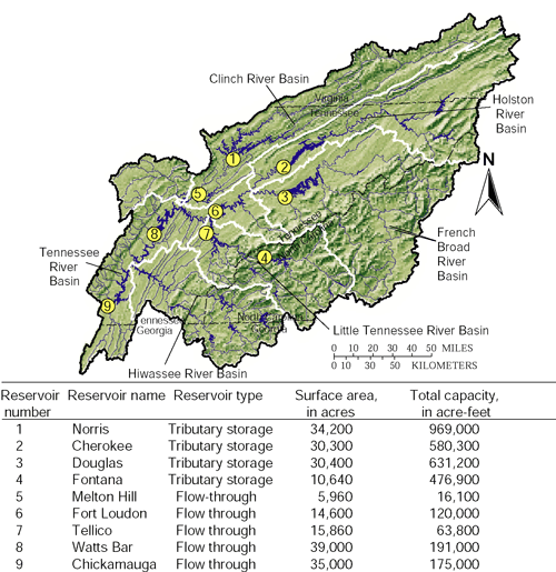 |
| Figure 2. Two types of major reservoirs are on five major tributaries of the Upper Tennessee River. |
Water Use
In 1995, withdrawals of surface and ground water in the Upper Tennessee River Basin totaled about 4.8 billion gallons per day. Surface-water withdrawals for once-through cooling at thermoelectric plants accounted for about 3.5 billion gallons per day, or 73 percent of this total. Other uses (fig. 3) were commercial and industrial, 702 million gallons per day; public and domestic supply, 394 million gallons per day; agricultural, 203.3 million gallons per day: and mining, 10.4 million gallons per day, all of which were predominantly surface-water withdrawals.(5) A total of 897 facilities were permitted to discharge wastewater in 1995 to area streams.
Total ground-water withdrawals in the basin for 1995 were about 138 million gallons per day and accounted for about 10.5 percent of the total non-thermoelectric water use in the basin. About 77 percent of the ground-water withdrawals were for public and domestic supply for over one-third of the basins population.
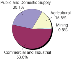 |
| Figure 3. Nonthermoelectric water use in the Upper Tennessee River Basin, 1995. (Thermoelectric water use accounted for 73 percent of the total water use.) |
Hydrologic Conditions
Understanding hydrologic variations over time is necessary for assessing water-quality conditions as well as for providing a context with which to evaluate trends. Overall, rainfall during the data-collection period was about 10 percent greater than the long-term mean values. Most of the excess rainfall occurred in the northern part of the basin, as the Knoxville and Tri-Cities weather stations both recorded about 4 inches per year more than their long-term averages of 46.7 and 41.3 inches, respectively. During this same period, rainfall at Chattanooga averaged only about 1 inch per year more than the long-term average of 53.3 inches.(6)
Although precipitation usually is distributed relatively evenly throughout the year in the Upper Tennessee River Basin with no pronounced dry or wet seasons, two relatively dry periods occurred in the late summer and fall of 1997 and 1998. These periods are reflected in the rainfall departures in figure 4 and streamflow discharges in figure 5.
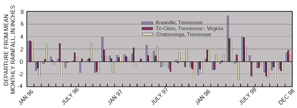 |
| Figure 4. Departures from mean monthly rainfall at three stations in the Upper Tennessee River Basin reflect hydrologic conditions during the 1996-98 study period. (Data from National Weather Service, Morristown, Tenn.) |
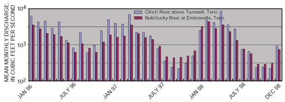 |
| Figure 5. Mean monthly discharge for the Clinch and Nolichucky Rivers reflect the abnormally dry summers of 1997 and 1998. |
Ground-Water Resources
Ground water in the Upper Tennessee River Basin occurs almost exclusively in unconfined water-table conditions with no regional flow systems. Ground-water flow systems usually are less than 10 square miles in areal extent and are largely controlled by the bedrock geology (fig. 6) and thickness of overlying regolith.
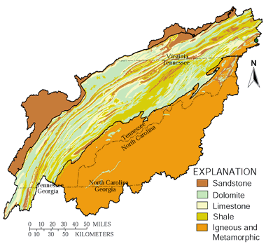 |
| Figure 6. Ground-water availability is a function of surface geology in the Upper Tennessee River Basin. |
The Cumberland Plateau is characterized by hard, relatively impermeable sandstone of Pennsylvanian age generally overlain by thin soils. Well yields generally range from 5 to 50 gallons per minute from fractures, faults, and bedding-plane openings. Over much of the province, however, reliable ground-water supplies are not obtainable. Similarly, the Blue Ridge physiographic province is characterized by fractured crystalline igneous and metamorphic rock of low porosity and little storage capacity. Well yields depend upon interception of water-bearing fracture systems and usually range from 10 to 25 gallons of water per minute where available.
The Valley and Ridge physiographic province is underlain by folded and extensively faulted limestone, dolomite, shale, and sandstones that occur in long subparallel belts trending southwest to northeast. The principal water-bearing units are the carbonate-based dolomites and limestones, which provide water for many cities and industries. Yields generally range from 5 to 200 gallons per minute, but wells penetrating extensive solution features may yield as much as 2,000 gallons per minute.(7) Solution features, such as caves and sinkholes with their inherent permeability, make the Valley and Ridge carbonate aquifers the most susceptible in the basin to contamination.
Biological Diversity
The Upper Tennessee River Basin is noted nationally for its diversity of freshwater fishes and mussels. The basin provides habitat for 174 species of fish, including 25 species that are non-native.
Of the 149 fish species native to the Upper Tennessee River, 29 are found only in the Tennessee and adjacent Cumberland River Basins, and 15 are found only in the Upper Tennessee River. Fifteen fish species in the basin are federally listed as endangered or threatened and 50 species are listed under management categories used by the four States.
 |
| The Upper Tennessee River Basin includes one of the world's most diverse freshwater mussel faunas. (Photograph courtesy of Richard Neves, Virginia Polytechnic and State University.) |
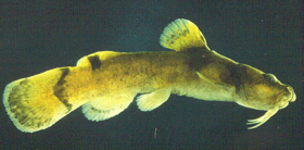 |
| The yellowfin madtom is on of the threatened fish species in the Upper Tennessee River Basin. (Photograph courtesy of the Tennessee Valley Authority.) |
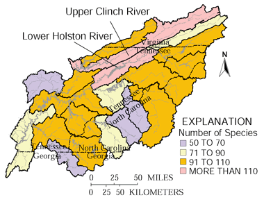 |
| Figure 7. Fish diversity is highest in the Lower Holston and Upper Clinch River systems. |
Most of the fish diversity in the basin is concentrated in the Valley and Ridge physiographic province, which includes 141 of the 149 native Upper Tennessee species, most notably in the Upper Clinch and lower Holston River Basins (fig. 7). The Clinch River alone is home to 126 Upper Tennessee River native species, 12 of which are federally protected and 41 of which are State listed. Four previously recorded fish species are no longer found in the Clinch River, the largest number of eliminated fish species for any Upper Tennessee drainage.
The Upper Tennessee River also includes one of the most diverse freshwater mussel fauna in the world with 85 different species having historically been recorded. Twenty-five of these species are no longer found in the basin, mostly because of habitat destruction associated with reservoir impoundment, and 11 are now believed to be extinct. Of the 60 freshwater mussel species now found in the Upper Tennessee River Basin, 30 species are under Federal protection and 52 species are listed by the States.
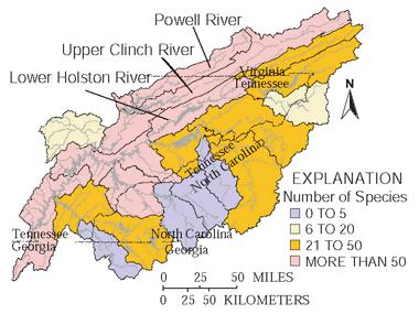 |
| Figure 8. Freshwater mussel diversity is highest in the Valley and Ridge physiographic province. |
As with fishes, most of the fresh-water mussel diversity is associated with the Valley and Ridge physiographic province, especially the Clinch River system (fig. 8). The Clinch River is now home to about 52 species of a previously recorded total of 79. Of the current total, 28 are federally listed and 38 are listed by the States.
Home to more than 300 globally rare species, the Upper
Clinch River system, which includes the Powell River, has attracted attention
from a number of environmental organizations including the designation
as one of the Last Great Places by the Nature Conservancy. The Clinch
River system also is considered to be one of the more biologically threatened
river systems in the country (fig. 9). Of the 178 freshwater fish and
mussel species presently inhabiting the Clinch River Basin, more than
one-fourth are considered to be at-risk.(8)
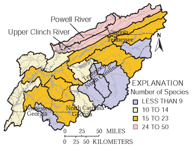 |
| Figure 9. The Upper Clinch and Powell Rivers have the highest numbers of freshwater fish and mussel species considered to be at risk.(8) |
Study Unit Design Focuses on Land Use
Chemical and biological samples were collected from selected rivers and streams draining different land-use areas to assess overall quality as well as the effects of specific land uses. The study focused on agricultural land use and unregulated streams in the Valley and Ridge physiographic province. At Basic Fixed Sites, water samples were collected monthly and during storms to assess runoff conditions. Synoptic sites were sampled only once during periods of average flow.
Springs, domestic wells, and specifically installed agricultural monitoring wells were sampled to assess overall ground-water quality in the basin. Ground-water studies focused on the dolomite and limestone areas of the Valley and Ridge province, which provide the best aquifers and are the most susceptible areas in the basin to ground-water contamination. (See Study Unit Design, page 23, for details.)
| Table of Contents || Previous Section || Next Section || Glossary U.S. Geological Survey Circular 1205 Suggested citation:
|
