
INTRODUCTION TO THE UPPER PART OF THE SOUTH-CENTRAL TEXAS STUDY UNIT
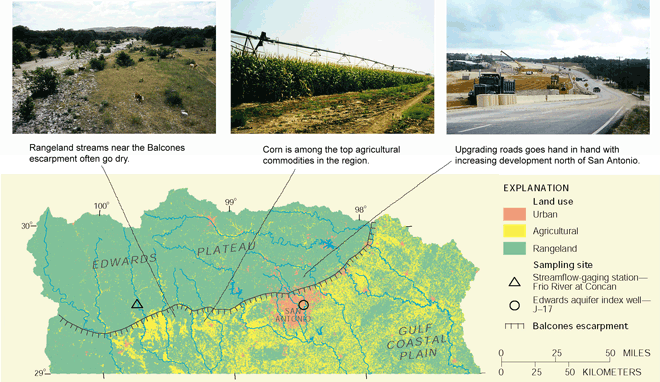
The upper part of the South-Central Texas Study Unit (hereinafter, Study Unit) encompasses parts of the topographically rugged and picturesque Edwards Plateau and the comparatively flat, gently coastward-sloping Gulf Coastal Plain physiographic regions. An abrupt topographic break, the Balcones escarpment, separates the two landforms (fig. 1).
San Antonio is the principal urban area in the Study Unit. The agricultural areas of primary interest are west of San Antonio. Rangeland predominates in the Edwards Plateau.
The Study Unit contains the Edwards aquifer in the Balcones fault zone, a zone of northeastward-trending parallel faults that straddles the Balcones escarpment. The Study Unit also contains the Trinity aquifer (fig. 2) in the Hill Country, the local name for the eastern part of the Edwards Plateau in the region.
|
|
| Figure 1. Land use in the Study Unit correlates with physiography. The rugged, thin-soiled terrain of the Edwards Plateau is largely undeveloped. The flatter, thicker-soiled terrain of the Gulf Coastal Plain is better suited to growing cropsprimarily hay, sorghum, wheat, corn, and oats. (Land use from Landsat thematic mapper scenes acquired in 199193 [1].) |
![Figure 2. Areal extent of the Edwards and Trinity aquifers sampled during 1996–98 (modified from [4]). The outcrop of the Edwards aquifer essentially is the recharge zone; the subcrop essentially is the confined zone. The outcrop of the Trinity aquifer is approximately coincident with the Hill Country. The subcrop of the Trinity aquifer (not shown), which extends beneath the Edwards aquifer, is not a source of water supply in the region and was not sampled.](images/sct_fig02.gif) |
| Figure 2. Areal extent of the Edwards and Trinity aquifers sampled during 199698 (modified from [4]). The outcrop of the Edwards aquifer essentially is the recharge zone; the subcrop essentially is the confined zone. The outcrop of the Trinity aquifer is approximately coincident with the Hill Country. The subcrop of the Trinity aquifer (not shown), which extends beneath the Edwards aquifer, is not a source of water supply in the region and was not sampled. |
An Unusual Physical System
Surface water and ground water in the Study Unit are uniquely interrelated. Rainfall reaches streams deeply incised into the marl, shale, and limestone of the Edwards Plateau as springflow and surface runoff. The streams generally gain water as they flow south-southeastward from headwaters in the higher elevations of the plateau. As the major streams flow across the faulted and fractured carbonate rocks of the Edwards aquifer outcrop (recharge zone), they lose substantial amounts of flow directly into the highly permeable aquifer.
Ground Water Predominates
Ground water accounts for nearly all of the water supply in the Study Unit (fig. 3), and the Edwards aquifer, one of the most productive aquifers in the world, is the principal source. Withdrawals from the Edwards aquifer meet the water-supply needs of more than 1.5 million people in the greater San Antonio region and support farming and ranching west of San Antonio. The aquifer sustains the flows of Comal and San Marcos Springs, which attract tourists to the region, yield base flow to the Guadalupe River to meet downstream water requirements, and provide habitat for several threatened and endangered species. The Edwards aquifer harbors diverse aquatic communities above and below land surface; at least 90 described species, one-half of which are subterranean, are unique to the region.
The Trinity aquifer, although much less productive than the Edwards aquifer, is the most commonly used and reliable source of water supply in the Hill Country.
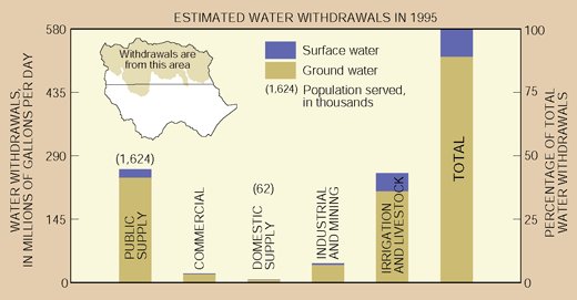 |
| Figure 3. Nearly all the withdrawals from the Study Unit were ground water. About 70 percent of the ground-water withdrawals were from the Edwards aquifer. |
Development is Increasing
The watersheds of major streams in the Edwards Plateau that recharge the Edwards aquifer were largely undeveloped rangeland in the late 1990sbut that is changing. A common sight in the area is the construction of new subdivisions on land that for generations has been devoted to ranching. Edwards, Bandera, and Kendall Counties were among the top 10 statewide and the top 50 nationally in percentage of population increase during 199098. Urban development in the Edwards aquifer recharge zone, particularly in Bexar County (San Antonio), also is increasing. Bexar County ranked fourth among counties statewide and 15th nationally in numeric population increase during 199098. Continued development on a scale suggested by those U.S. Census Bureau statistics has the potential to affect surface- and ground-water quality in the Study Unit.
The Edwards Aquifer Is Particularly Vulnerable to Contamination
The highly permeable rocks that compose the Edwards aquifer recharge zone, and development in the watersheds of major streams in the Edwards Plateau and in the recharge zone, make the Edwards aquifer particularly vulnerable to contamination. That vulnerability and the dependence of so many people on the aquifer combine to make the water quality of the Edwards aquifer and the streams that recharge it a critical issue for the future of the region.
Climate and Hydrologic Conditions Can Affect Water Quality
Hydrologic conditions in the Study Unit often are extreme. Months-long droughts that strain water supplies and produce widespread crop failure commonly are followed by wet periods that include torrential rains and flash floods. Such was the pattern during the 199698 period of intensive sampling (figs. 4, 5).
Whether hydrologic conditions are wet or dry can affect water quality. For example, during wet conditions, proportionately more of the streamflow is surface runoff. Runoff that contains excessive nutrients, pesticides, or other contaminants washed off land surfaces can degrade stream quality. During dry conditions, stream quality is more strongly influenced by the quality of the base flow (and wastewater-treatment plant discharge, if present).
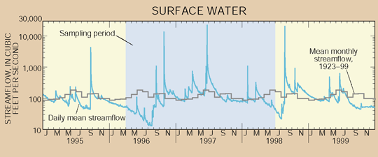 |
| Figure 4. Daily mean streamflow of the Frio River at Concan, a basic site for sampling, reflects the regional droughts of 1996 and 1998 and the subsequent wet periods. Streamflow at the site can increase almost instantly by a factor of 100 or more for short periods in response to intense rainfall. The region near the Balcones escarpment is more prone to flash floods than anywhere else in the Nation [5, p. 63]. |
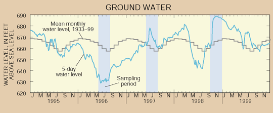 |
| Figure 5. The water level in Edwards aquifer index well J17 in Bexar County rose substantially during wet periods following the regional droughts of 1996 and 1998; and reflects the effects of pumpage at San Antonio as well as natural fluctuations in recharge and discharge. Although pumpage at San Antonio has increased fivefold since the 1930s, Edwards aquifer water levels show no long-term declines because the aquifer readily accepts recharge when rainfall is plentiful. |
The Study is a Benchmark for Changes to Come
This study is more of a benchmark from which to measure future water-quality changes than a documentation of problems. Population growth and development bring changes in land use, and land use can have a strong influence on water quality. Accordingly, part of the study design focuses on land use. Surface-water sampling was done to assess the effects of urban, agricultural, and rangeland use on stream quality during stormflows and during normal and low flows. Ground-water sampling was done to assess the overall quality of ground water in the Edwards and Trinity aquifers and to assess the relation between ground-water quality and urban land use in the recharge zone in San Antonio. Synoptic samples were collected primarily from domestic and monitor wells in the Edwards aquifer recharge zone, public-supply wells in the Edwards aquifer confined zone, and domestic wells in the upper and middle zones of the Trinity aquifer. (See Study Unit Design, p. 22.)
| Table of Contents || Previous Section || Next Section || Glossary U.S. Geological Survey Circular 1212 Suggested citation:
|
