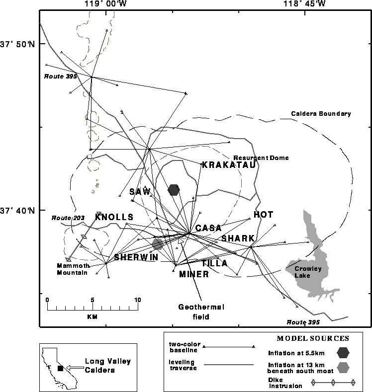
VHP-bar


Long Valley Caldera 2-Color EDM Network

redrule


EDM data format

References


The two-color EDM network

Horizontal deformation is monitored by measuring changes in the baseline lengths of the two-color geodimeter network (Fig. 1) . Baseline lengths are measured from several times weekly to several times yearly (Fig. 2) . The more frequently measured lines, including the stations KNOL, SHER, MINE, TILL, SHARK, HOT and KRAK, are observed from the central monument CASA (see Fig.2) . The other stations (MIKE, KNOB, DEAD, MICR, BALD, SAGE and KRAK) are observed from the LKT monument, and are measured less frequently.

The USGS has used the change in the length of the CASA-KRAK baseline to estimate the vertical deformation at the resurgent dome when direct measurements are unavailable. This application is based on the similarity between the history of vertical deformation recorded by the leveling surveys and the horizontal deformation along the CASA-KRAK EDM baseline.

Methods used to extract the displacement and its error for each of the baselines are described in Langbein et al. (1993) and Langbein et al. (1995). The formal instrument variance of the two-color measurements is σ2 = a2 + b2 L2, where a = 0.3 mm and b = 0.12 ppm of the baseline length L (Langbein et al., 1993). This does not account for any time-dependent noise due to local motion of the geodetic monuments (Langbein et al., 1995), which is of the order of 1 mm/yr1/2
. The two-color geodimeter measures distances to a precision of 0.5 to 1.0 mm for ranges between 3 and 8 km (Langbein and Johnson, 1997).

The general trend of the data is 1) a general decrease in the rate of extension from 1983 through most of 1989, 2) an abrupt increase in the rate of extension on several baselines to 5 cm/yr. from late 1989 through early 1990, and 3) a decrease to 2 to 3 cm/yr. extension rate that has persisted since mid-1990.

For more details, contact: John Langbein (langbein@usgs.gov)

Fig. 1. This map shows the locations of baselines that are measured in the Long Valley Caldera, near Mammoth Lakes, Calif., using a two-color laser distance measuring instrument (geodimeter).
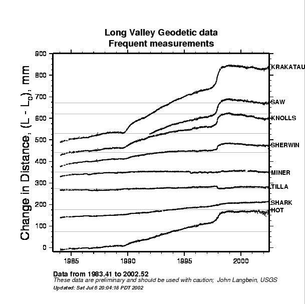
 Fig. 2. Plot of the changes in length of 8 frequently measured baselines is available below. These baselines, which use the central station at CASA as a common end point, have been measured approximately 3 times each week since early 1984.
Long Valley 2-color edm network Long Valley caldera 2-color EDM data


References


M. Battaglia, P. Segall, J. Murray, P. Cervelli, J. Langbein, 2002. .The mechanics of unrest at Long Valley caldera, California: 1. Modeling the geometry of the source using GPS, leveling and 2-color EDM data. J. Volcanol. Geotherm. Res. (in press).

Langbein, J., 1989. Deformation of the Long Valley caldera, eastern California, from mid-1983 to mid-1988: measurements using two-color geodimeter, J. Geophys. Res., 94, 3833-3849.

Langbein, J., Hill, D.P., Parker, T.N., Wilkinson, S.K., 1993. An episode of reinflation of the Long Valley Caldera, eastern California, 1989-1991. J. Geophys. Res , 98, 15,851-15,870.

Langbein, J. Dzurisin, D., Marshall, G., Stein, R., Rundle, J., 1995. Shallow and peripheral volcanic sources of inflation revealed by modeling two-color geodimeter and leveling data from Long Valley Caldera, California, 1988-1992. J Geophys. Res. 100, 12487-12,495.

Langbein, J., Johnson, H., 1997. Correlated errors in geodetic time series; implications for time-dependent deformation. J. Geophys. Res. 102, 591-604.


| Top | Home |

valid-html401