|
|
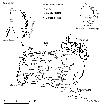
Leveling, in which height differences between stations are measured with a precise optical-level, has been used to measure the vertical deformation along the 65-km-long line along Hwy 365 from Tom's Place to Lee Vining and along several other routes within the caldera (Fig. 1; Table 1 ). The benchmark C916 (Fig. 1) is the elevation datum (2072.54196 m) for all the leveling surveys. The Highway 395 route was surveyed in 1932, 1957, 1975, 1980, each summer from 1982 to 1988, and again in 1992, 1995 and 1997 (Denlinger, 1984; Savage et al., 1987; Langbein et al., 1995). Complete leveling of the caldera occurred each summer from 1982 to 1986, and in 1988 and 1992 (Langbein et al., 1995). The leveling surveys have been run to standards equal to those required for second-order, class II levels or first-order, class II levels. The standard error for each elevation difference can be taken to be 3 mm/L1/2, where L is the distance between benchmarks in km (Langbein et al., 1995). Leveling observations were corrected for rod scale and temperature, level collimation, and for astronomic, refraction and magnetic effects (Balazs and Young, 1982). Leveling surveys were not referenced to the NAVD88 datum as the goal of these surveys was to monitor relative elevation changes within the caldera. |