Long Valley Caldera Hydrologic Studies
Introduction
The USGS monitors springs, streams, wells, fumaroles,
and precipitation in Long Valley to study the natural hydrologic variations
and the response of the hydrologic system to volcanic and tectonic processes
(Howle and Farrar, 1996, Howle and Farrar, 2001, Sorey and Farrar, 1998).
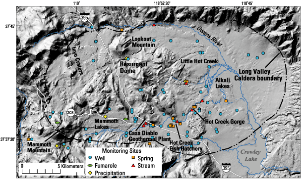
The locations of all monitoring sites are shown below. Hydrologic
data from key monitoring sites are posted every day on the Long Valley
Observatory web site (http://lvo.wr.usgs.gov/HydroStudies.html)
allowing to quickly review recent data for real or
(faulty) equipment induced anomolies.
The USGS Ground-water Monitoring Network in Long Valley is maintained
by Chris Farrar (cdfarrar@usgs.gov) and Jim Howle (jfhowle@usgs.gov),
Carnelian Bay Field Office, California District, Water Resources Division,
USGS.
Hydrothermal System
Long Valley caldera hosts an active hydrothermal
system that includes hot springs, fumaroles (steam vents), and
mineral deposits (Sorey et al., 1991). Hot springs exist primarily
in the eastern half of the caldera where land-surface elevations
are relatively low; fumaroles exist primarily in the
western half where elevations are higher. Hot springs discharge
primarily in Hot Creek Gorge, along Little Hot Creek, and in the
Alkalai Lakes area. Springs at the Hot Creek Fish Hatchery contain
a small component of thermal water; their slightly elevated temperature
(~16°C) is required for operations at the hatchery.
In hydrothermal systems the circulation of ground-water is driven
by a combination of topography and heat sources. In Long Valley caldera,
flow starts in the west and continues to the southeast around the resurgent
dome and then eastward toward Hot Creek and Crowley Lake. Reservoir temperatures
in the volcanic fill decline from 230°C near the Inyo Craters to
50°C near Crowley Lake due to a combination of heat loss and mixing with
cold water.
The recently completed Long Valley Exploratory Well (http://lvo.wr.usgs.gov/LVEW.html),
which was drilled on the resurgent dome to a depth of 9,832
feet (2,997 meters), has provided new information on the history
of hydrothermal activity in the caldera, and will be used to study
heat and fluid circulation in the region.
Geothermal Power Development
Wells drilled on the southwest side of the resurgent
dome at Casa Diablo tap into the caldera's hydrothermal system by pumping
hot water (170°C) to supply three hydrothermal power plants that
generate about 40 megawatts of electricity. Using a binary technology,
a secondary fluid (isobutane) is heated by the pressurized geothermal
water, vaporized, and then run through the generating turbines. Cooled
geothermal water is reinjected underground.
The hydrologic monitoring program has detected changes in the hydrologic
system caused by geothermal development and variations in precipitation
and recharge (Howle and Farrar, 1997). For example, we have delineated
decreases in thermal-spring discharge at sites within about 5 km to the
east of Casa Diablo that are caused by subsurface pressure declines
at the geothermal well field. No changes have as yet been detected
in the springs in Hot Creek gorge. There has also been an increase in
steam discharge at Casa Diablo and sites farther west due to increased
boiling in the geothermal reservoir caused by geothermal production.
Causes of Variations in the Hydrologic System:
- Precipitation and ground-water recharge:
Streamflow at HCF and ground-water levels in wells SC-1 and SC-2
show large-scale variations primarily related to precipitation and
ground-water recharge. These processes also influence water levels
in wells tapping deeper aquifers, but to a lesser degree.
- Geothermal fluid production:
Water levels in geothermal well CW-3 (5 km east of Casa Diablo)
show the effects of pressure reductions caused by the withdrawal
of geothermal fluid at Casa Diablo; water levels declined significantly
in 1991 when the production rate was increased to supply two new
power plants. A similar water level decline has not yet occurred
in geothermal observation well CH-10B, located 9 km east of
Casa Diablo.
- Earthquakes: Water-levels in
wells LKT, CH10-B, Santa Fe, and CW-3 show changes in response to
relatively large local (>M~4) and regional earthquakes (>M~5)
and to large distant earthquakes (>M6). Water levels typically
drop rapidly for several days following an earthquake; water-level
recovery takes weeks to months. For example, the hydrograph for well
LKT shows responses to earthquakes on July 11, 1989 (M4.6 in
Long Valley area), October 17, 1989 (M~7 Loma Prieta), October
24, 1990 (M5.7 north of Long Valley caldera), and June 28, 1992 (M7.3
Landers).
- Crustal Deformation: The relatively
rapid and large water-level declines seen in wells LKT, CH10-B, Santa
Fe, and CW-3 in the fall of 1997 correlate with the increase in extension
rate across the resurgent dome that began in October and continued
for the rest of the year. Relatively high strain rates may be
required to cause measurable responses in the hydrologic system
because strain-induced water-level changes tend to be dissipated
by the increase in ground-water flow caused by localized fluid-pressure
changes. Quantitative analysis of the relationship between strain
rate and water-level changes is in progress. To date, no correlation
has been delineated between strain rates and hot-spring discharge
in Hot Creek gorge.
- Barometric pressure and earth tides:
Water-level data from the continuously monitored wells are filtered
to remove the effects of barometric pressure and earth tides.
References
Howle, J.F. and Farrar, C.D., 2001. Hydrologic data for
Long Valley Caldera, Mono County, California, 1994-96. Open-File Report
- U. S. Geological Survey, Report: OF 00-0230, 155 pp.
Howle, J.F; Farrar, C.D., 1997. Deformation in the
Casa Diablo geothermal well field, Long Valley Caldera, eastern California.
Open-File Report - U. S. Geological Survey, Report: OF 97-0047, pp.31-35.
Howle, J.F. and Farrar, C.D., 1996. Hydrologic data for Long Valley
Caldera, Mono County, California, 1978-93. Open-File Report - U. S. Geological
Survey, OF 96-0382.
Sorey, M.L. and Farrar, C.D., 1998. Hydrologic and chemical data
from the Long Valley Hydrologic Advisory Committee Monitoring Program
in Long Valley Caldera, Mono County, California, 1988-1997. Open-File
Report - U. S. Geological Survey, OF 98-0070, 49 pp.
Sorey, M.L., Suemnicht, G.A., Sturchio, N.C., and
Nordquist, G.A., 1991, New evidence on the hydrothermal system in Long
Valley Caldera, California, from wells, fluid sampling, electrical geophysics,
and age determinations of hot spring deposits: Journal of Volcanology
and Geothermal Research, v. 48, no. 3-4, p. 229-263.