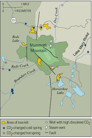
| Since 1980, scientists have monitored geologic unrest in Long Valley Caldera and at adjacent Mammoth Mountain, California. After a persistent swarm of earthquakes beneath Mammoth Mountain in 1989, geologists discovered that large volumes of carbon dioxide (CO2 ) gas were seeping from beneath this volcano. This gas is killing trees on the mountain and also can be a danger to people. The U.S. Geological Survey (USGS) continues to study the CO2 emissions to help protect the public from this invisible potential hazard. |
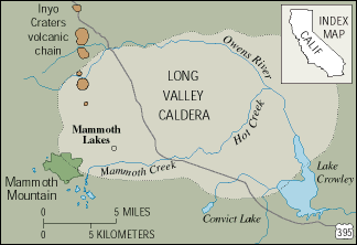
Mammoth Mountain is a young volcano on the southwest rim of Long Valley Caldera, a large volcanic depression in eastern California. The Long Valley area, well known for its superb skiing, hiking, and camping, has been volcanically active for about 4 million years. The most recent volcanic eruptions in the region occurred about 200 years ago, and earthquakes frequently shake the area. Because of this, the U.S. Geological Survey (USGS) operates an extensive network of instruments to monitor the continuing unrest in the Long Valley area.
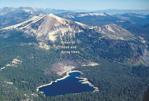
Numerous small earthquakes occurred beneath Mammoth Mountain from May to November 1989. Data collected from monitoring instruments during those months indicated that a small body of magma (molten rock) was rising through a fissure beneath the mountain. During the next year, U.S. Forest Service rangers noticed areas of dead and dying trees on the mountain. After drought and insect infestations were eliminated as causes, a geologic explanation was suspected. USGS scientists then made measurements and discovered that the roots of the trees were being killed by exceptionally high concentrations of carbon dioxide (CO2) gas in the soil. Today, areas of dead and dying trees at Mammoth Mountain total more than 100 acres. The town of Mammoth Lakes, just east of this volcano, has not been affected.
|
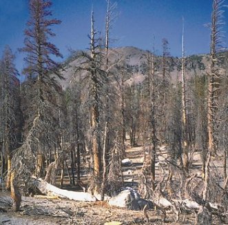
| Mammoth Mountain, a young volcano in eastern California, sits on the southwest rim of Long Valley Caldera. In 1994, scientists detected high concentrations of CO2 gas in the soil on Mammoth Mountain. This invisible gas, seeping from beneath the volcano, is killing trees on the sides of the mountain and can pose a threat to humans. Recent measurements indicate that the total rate of CO2 gas emission at Mammoth Mountain is close to 300 tons per day. In this photo, large areas of dead and dying trees are visible near Horseshoe Lake, on the southeast flank of Mammoth Mountain. (Copyrighted photo courtesy of John D. Rogie.) |
|
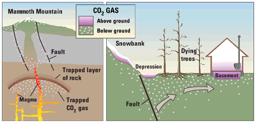
When CO2 from soil leaves the ground, it normally mixes with the air and dissipates rapidly. CO2 is heavier than air, however, and it can collect at high concentrations in the lower parts of depressions and enclosures, posing a potential danger to people. Breathing air with more than 30% CO2 can very quickly cause unconsciousness and death. Therefore, poorly ventilated areas above and below ground can be dangerous in areas of CO2 seepage. Where thick snowpacks accumulate in winter, the CO2 can be trapped within and beneath the snow. Dangerous levels of CO2 have been measured in pits dug in the snowpack in tree-kill areas on Mammoth Mountain, and snow-cave camping in such areas is not advised.
|
| CO2 gas seeping from the ground at Mammoth Mountain is likely derived from magma (molten rock) beneath the volcano. In 1989, rising magma may have opened cracks, allowing large amounts of trapped CO2 gas to leak upward along faults. High concentrations of CO2 in soil can kill the roots of trees. CO2 gas is heavier than air, and when it leaks from the soil, it can collect in snowbanks, depressions, and poorly ventilated enclosures, such as cabins and tents, posing a potential danger to people. |
|
||||
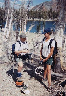
Recent measurements at Mammoth Mountain indicate that the total rate of CO2 gas emission is close to 300 tons per day. This value varies on both short (days to weeks) and long (months to years) time scales because of changes in atmospheric conditions and in the rate at which gas is being released from beneath the volcano.
Past eruptions at Mammoth Mountain, such as the phreatic (steam blast) eruptions that occurred about 700 years ago on the volcanoís north flank, may have been accompanied by CO2 emissions. Scientists think that the current episode of high CO2 emissions is the first such activity on the mountain for at least 250 years because the oldest trees in the active tree-kill areas are about that age. Carbon-isotopic analyses of the annual growth rings in trees near the margins of the tree-kill areas imply that the gas-emission rate reached a peak in 1991, subsequently declined, and then has been relatively stable since about 1996.
CO2 and other volcanic gases, like helium, seeping from Mammoth Mountain appear to be leaking from a large reservoir of gas supplied by repeated intrusions of magma. Tree-ring evidence from near springs on the mountainís flanks shows that some CO2 gas was leaking before 1989 and dissolving in the ground-water system. It is likely that the latest intrusion of magma (in 1989) opened deep fractures, increasing the rate of gas seepage.
The continuing occurrence of small earthquakes and CO2 seepage beneath Mammoth Mountain are only two of the many signs of volcanic unrest in the area. Earthquakes and ground uplift are also occurring within the central part of Long Valley Caldera, only a few miles east of Mammoth Mountain, and the Mono-Inyo Craters volcanic chain to the north has had small volcanic eruptions every few hundred years for the past 4,000 years.
Scientists with the
USGS Volcano Hazards Program are closely monitoring CO2
emissions and other geologic hazards at Mammoth Mountain. The work of
these scientists is only part of the USGS Volcano Hazards Programís
ongoing efforts to protect peopleís lives and property in all of the
volcanic regions of the United States, including the Pacific Northwest,
Alaska, Hawaii, and Arizona.
Michael L. Sorey, Christopher D. Farrar, Terrance M. Gerlach, Kenneth A. McGee, William C. Evans, Elizabeth M. Colvard, David P. Hill, Roy A. Bailey, John D. Rogie, James W. Hendley II, and Peter H. Stauffer
Graphic design
by
Susan
Mayfield and Sara Boore
Banner design
by Bobbie Myers
COOPERATING
ORGANIZATIONS
Mammoth
Mountain Ski Area
Town of
Mammoth Lakes
U.S.
Department of Agriculture, Forest Service
Pennsylvania
State University
For more information contact:
Earthquake
Information Hotline (650) 329?4085
U.S.
Geological Survey, Mail Stop 977
345
Middlefield Road, Menlo Park, CA 94025
Related Fact Sheets
Living With a Restless Caldera - Long Valley, California (USGS Fact Sheet 108?96)
Future Eruptions in Californiaís Long
Valley Area - What ís Likely? (USGS Fact Sheet 073?97)
U.S. GEOLOGICAL SURVEY REDUCING THE RISK FROM VOLCANO HAZARDS
Download a PDF version of this fact sheet (1.43 Mb)
![]()