Skip Links

USGS - science for a changing world

Data Series 953

Photos and Maps


Home | Abbreviations | Contents | Photos and Maps | Navigation Data | Logs | Metadata | Citation Page


Each map below shows how the flight is divided into areas and how theflightpath is divided into 5-minute (time) segments. Each segment is represented by alternating purple and yellow lines. Pages containing thumbnail images of the photographs, referred to as contact sheets, were created based on these segments. Click on each segment name to access the respective contact sheet. Refer to Table 1 for a list of images, latitude and longitude, and date and time by contact sheet.

Each segment, which has a corresponding contact sheet, is labeled with the following filename format: yyyy_mmdd_hhmmss, where yyyy denotes the year, mmdd denotes the month and day, and hhmmss denotes the start of the 5-minute segment of time during which those photographs were taken. For example, image 2014_0905_164000 was taken September 5, 2014, starting at 16:40:00 Coordinated Universal Time (UTC). All times refer to UTC. Best effort was made to set the camera's internal clock to within 1 second of UTC at the beginning of the flight.

2014-327-FA - Area 1 - Key Largo to Hillsboro Beach, Florida

2014-327-FA - Area 1 Map ds953_2014_0905_130851 ds953_2014_0905_131000 ds953_2014_0905_131500 ds953_2014_0905_132000 ds953_2014_0905_132500 ds953_2014_0905_133000 ds953_2014_0905_133500 ds953_2014_0905_134000 ds953_2014_0905_134500 ds953_2014_0905_135000 ds953_2014_0905_135500 ds953_2014_0905_140000 ds953_2014_0905_140500 ds953_2014_0905_141000 ds953_2014_0905_141500 ds953_2014_0905_142000

Figure 3A. Area 1 - Key Largo to Hillsboro Beach, Florida. Map showing the baseline coastal oblique aerial survey flightpath divided into 5-minute (time) segments. The flightpath is represented by the alternating purple and yellow lines. Pages containing thumbnail images of the photographs, referred to as contact sheets, were created based on these segments. Click on the 5-minute segment name to view each contact sheet.

2014-327-FA - Area 2 - Hillsboro Beach to Fort Pierce, Florida

2014-327-FA - Area 2 Map Fort Pierce Inset Map Fort Pierce inset Map ds953_2014_0905_142500 ds953_2014_0905_143000 ds953_2014_0905_143500 ds953_2014_0905_144000 ds953_2014_0905_144500 ds953_2014_0905_145000 ds953_2014_0905_145500 ds953_2014_0905_151500 ds953_2014_0905_152000

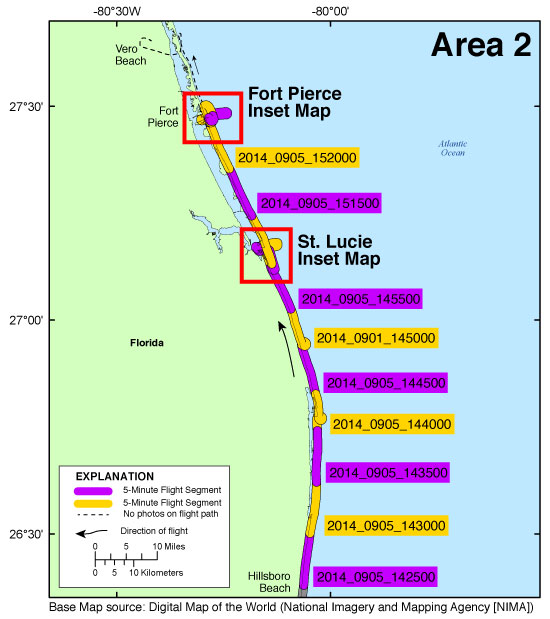
Figure 3B. Area 2 - Hillsboro Beach to Fort Pierce, Florida. Map showing the baseline coastal oblique aerial survey flightpath divided into 5-minute (time) segments. The flightpath is represented by the alternating purple and yellow lines. Pages containing thumbnail images of the photographs, referred to as contact sheets, were created based on these segments. Click on the 5-minute segment name to view each contact sheet. Click on an inset box to view a detailed map of the area.

2014-327-FA - Area 3 - Fort Pierce to the Canaveral National Seashore, Florida

2014-327-FA - Area 3 Map Port Canaveral Inset Map Kennedy Space Center, Cape Area Inset Map ds953_2014_0906_125000 ds953_2014_0906_125500 ds953_2014_0906_130000 ds953_2014_0906_130500 ds953_2014_0906_131000 ds953_2014_0906_131500 ds953_2014_0906_132000 ds953_2014_0906_132500 ds953_2014_0906_133000 ds953_2014_0906_140000 ds953_2014_0906_140500 ds953_2014_0906_141000 ds953_2014_0906_141500

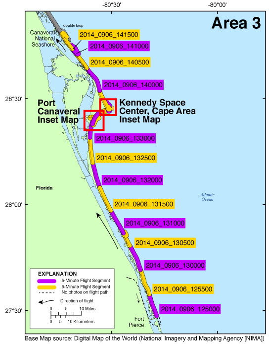
Figure 3C. Area 3 - Fort Pierce to the Canaveral National Seashore, Florida. Map showing the baseline coastal oblique aerial survey flightpath divided into 5-minute (time) segments. The flightpath is represented by the alternating purple and yellow lines. Pages containing thumbnail images of the photographs, referred to as contact sheets, were created based on these segments. Click on an 5-minute segment name to view each contact sheet. Click on the inset box to view a detailed map of the area.

2014-327-FA - Area 4 - The Canaveral National Seashore to S.t Augustine, Florida

2014-327-FA - Area 4 Map Ponce Inlet Inset Map Matanzas Inlet Inset Map St. Augustine Inlet Inset Map Inset Map ds953_2014_0906_142000 ds953_2014_0906_142500 ds953_2014_0906_143000 ds953_2014_0906_143500 ds953_2014_0906_144500 ds953_2014_0906_145000 ds953_2014_0906_145500 ds953_2014_0906_150000 ds953_2014_0906_150500 ds953_2014_0906_151000 ds953_2014_0906_152000 ds953_2014_0906_152500 ds953_2014_0906_180000 ds953_2014_0906_180500

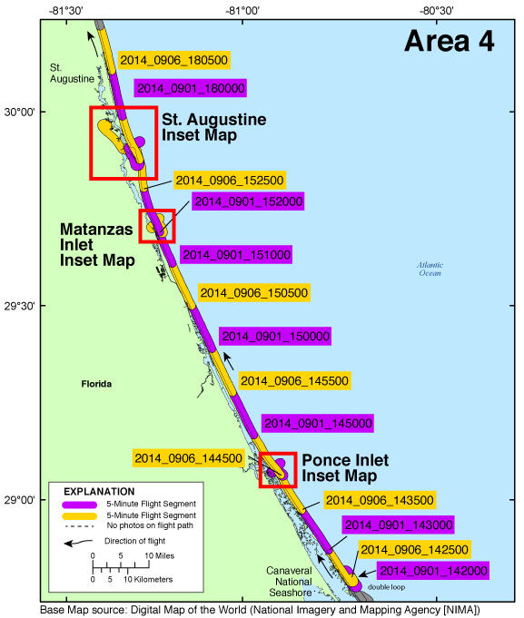
Figure 3D. Area 4 - Canaveral National Seashore to St. Augustine, Florida. Map showing the baseline coastal oblique aerial survey flightpath divided into 5-minute (time) segments. The flightpath is represented by the alternating purple and yellow lines. Pages containing thumbnail images of the photographs, referred to as contact sheets, were created based on these segments. Click on an 5-minute segment name to view each contact sheet. Click on the inset box to view a detailed map of the area.

2014-327-FA - Area 5 - St. Augustine to the Florida/Georgia Border

2014-327-FA - Area 5 Map St. Johns Inset Map ds953_2014_0906_181000 ds953_2014_0906_183000 ds953_2014_0906_183500 ds953_2014_0906_184000

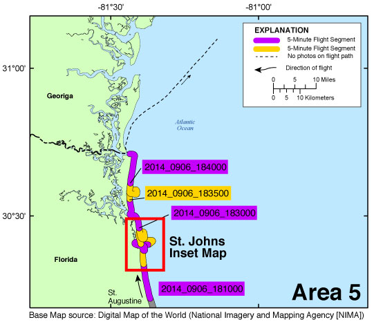
Figure 3E. Area 5 - St. Augustine to the Florida/Georgia border. Map showing the baseline coastal oblique aerial survey flightpath divided into 5-minute (time) segments. The flightpath is represented by the alternating purple and yellow lines. Pages containing thumbnail images of the photographs, referred to as contact sheets, were created based on these segments. Click on the 5-minute segment name to view each contact sheet. Click on the inset box to view a detailed map of the area.


St. Lucie Inset Map | Fort Pierce Inset Map | Port Canaveral Inset Map | Kennedy Space Center, Cape Area Inset Map | Ponce Inlet Inset Map
Matanzas Inlet Inset Map | St. Augustine Inlet Inset Map | St. Johns River Inlet Inset Map


Home | Abbreviations | Contents | Photos and Maps | Navigation Data | Logs | Metadata | Citation Page

Accessibility FOIA Privacy Policies and Notices

Take Pride in America logo USA.gov logo U.S. Department of the Interior | U.S. Geological Survey
URL: http://pubsdata.usgs.gov/pubs/ds/0953/html/ds953_photos.html
Page Contact Information: GS Pubs Web Contact
Page Last Modified: Monday, 28-Nov-2016 20:42:43 EST