|
Version 1.0 Introduction
Layer Information
System Requirements
Information For Advanced Users
References
Links
Version 1 User's Guide
Start Application
|
Information For Advanced Users
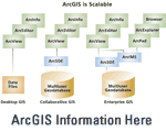
While the GCG Online application provides a number of useful and sophisticated geoprocessing and cartographic functions related to the geologic framework of the Gulf Coast Region, some users might find the need for more advanced GIS functionality. Some of this functionality may include sophisticated queries, and advanced cartographic functions including labeling and annotation. Given the interoperable nature of the GCG Online product, these data can be used in a variety of applications. The following options are available using the GCG Online map service:
-
 Using
ArcGIS Desktop--The services implemented in the GCG Online application and interface can be easily integrated into your existing data in any version of ArcGIS Desktop. Add an internet server using the “Add Internet Server” dialogue in ArcCatalog. The internet host name will be http://certmapper.cr.usgs.gov. Once the internet server has been successfully added, select the map service name, “gulfcoast_miocene1.” This service can be used in either ArcCatalog or ArcMap. For more details related to ArcGIS Desktop products, visit the ArcGIS product overview homepage at http://www.esri.com/software/arcgis/ Using
ArcGIS Desktop--The services implemented in the GCG Online application and interface can be easily integrated into your existing data in any version of ArcGIS Desktop. Add an internet server using the “Add Internet Server” dialogue in ArcCatalog. The internet host name will be http://certmapper.cr.usgs.gov. Once the internet server has been successfully added, select the map service name, “gulfcoast_miocene1.” This service can be used in either ArcCatalog or ArcMap. For more details related to ArcGIS Desktop products, visit the ArcGIS product overview homepage at http://www.esri.com/software/arcgis/
-
 Using
ArcExplorer--The GCG Online map service can also be integrated with existing data using a free GIS software viewer called ArcExplorer. For additional information regarding ArcExplorer and to download this free application, visit the ArcExplorer homepage at http://www.esri.com/software/arcexplorer/. Using
ArcExplorer--The GCG Online map service can also be integrated with existing data using a free GIS software viewer called ArcExplorer. For additional information regarding ArcExplorer and to download this free application, visit the ArcExplorer homepage at http://www.esri.com/software/arcexplorer/.
|