
usSEABED: Pacific Coast (California, Oregon, Washington) Offshore Surficial-Sediment Data Release
2006, Version 1.0
U.S. Geological Survey Data Series 182
By Jane A. Reid, Jamey M. Reid, Chris J. Jenkins, Mark Zimmermann, S. Jeffress Williams, and Michael E. Field
|
|
Abstract
| Over the past 50 years there has been an explosion in scientific interest, research effort, and information gathered on the geologic sedimentary character of the continental margin of the United States. Data and information from thousands of publications have greatly increased our scientific understanding of the geologic origins of the margin surface but rarely have those data been combined and integrated.
This publication is the first release of the Pacific coast data from the usSEABED database. The report contains a compilation of published and unpublished sediment texture and other geologic data about the sea floor from diverse sources. usSEABED is an innovative database system developed to unify assorted data, with the data processed by the dbSEABED system. Examples of maps displaying attributes such as grain size and sediment color are included. This database contains information that is a scientific foundation for the U.S. Geological Survey (USGS) Sea floor Mapping and Benthic Habitats project and the Marine Aggregate Resources and Processes assessment project, and will be useful to the marine science community for other studies of the Pacific coast continental margin.
The publication is divided into 10 sections: Home, Introduction, Content, usSEABED (data), dbSEABED (processing), Data Catalog, References, Contacts, Acknowledgments, and Frequently Asked Questions. Use the navigation bar on the left to navigate to specific sections of this report. Underlined topics throughout the publication are links to more information. Links to specific and detailed information on processing and to those to pages outside this report will open in a new browser window.
|
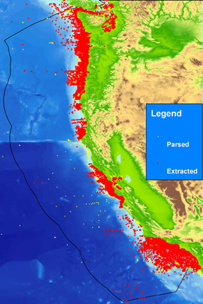
Figure 1. usSEABED data for the Pacific coast showing locations of the extracted (EXT, in red) and parsed (PRS, in yellow) outputs. The EXT data are from numeric, lab-based analyses. The PRS data consist of numeric values parsed from text-based descriptions. Black line defines the limit of the U.S. Exclusive Economic Zone. |
CITATION: This document should be cited as:
Reid, J.A., Reid, J.M., Jenkins, C.J., Zimmermann, M., Williams, S.J., and Field, M.E., 2006, usSEABED: Pacific Coast (California, Oregon, Washington) offshore surficial-sediment data release: U.S. Geological Survey Data Series 182, version 1.0. Online at https://pubs.usgs.gov/ds/2006/182/
 To view files in PDF format, download free copy of Adobe Reader. To view files in PDF format, download free copy of Adobe Reader.
|
Any use of trade names is for descriptive purposes only and does not imply endorsement by the U.S. Government.
Home | Contents | Site Map | Introduction | usSEABED | dbSEABED | Data Catalog | References | Contacts | Acknowledgments | Frequently Asked Questions | Disclaimer | Accessibility
Accessibility | FOIA | Privacy | Policies and Notices
U.S. Department of the Interior U.S. Geological Survey
URL: https://pubs.usgs.gov/ds/2006/182/
maintained by Michael Diggles
last modified December 9, 2011 (mfd)
|