
U.S. Geological Survey
Data Series 184
version 1.0
U.S.
Geological Survey
Data Series 184
version 1.0
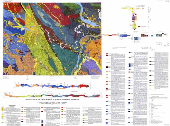
Database for the Geologic Map of the Chelan 30-Minute by 60-Minute Quadrangle, Washington (I-1661)
By R.W. Tabor, V.A. Frizzell, Jr., J.T. Whetten, R.B. Waitt, D.A. Swanson, G.R. Byerly, D.B. Booth, M.J. Hetherington, and R.E. Zartman
 |
|
This digital map database has been prepared by R.W. Tabor from the published Geologic map of the Chelan 30-Minute Quadrangle, Washington. Together with the accompanying text files as PDF, it provides information on the geologic structure and stratigraphy of the area covered. The database delineates map units that are identified by general age and lithology following the stratigraphic nomenclature of the U.S. Geological Survey. The authors mapped most of the bedrock geology at 1:100,000 scale, but compiled Quaternary units at 1:24,000 scale. The Quaternary contacts and structural data have been much simplified for the 1:100,000-scale map and database. The spatial resolution (scale) of the database is 1:100,000 or smaller. This database depicts the distribution of geologic materials and structures at a regional (1:100,000) scale. The report is intended to provide geologic information for the regional study of materials properties, earthquake shaking, landslide potential, mineral hazards, seismic velocity, and earthquake faults. In addition, the report contains information and interpretations about the regional geologic history and framework. However, the regional scale of this report does not provide sufficient detail for site development purposes. |
Read the Readme file (chel_readme.pdf; 136 KB)
Read the metadata (chelmetadata.txt; 160 KB)
Download the digital data package (chelcovers3.tar.gz; 904-KB compressed file that opens into a 4.8-MB folder containing 11 files)
Download Description of Map Units (DMU); text only (chelanDMU.pdf; 980 KB)
Go to the PDF form of this publication, USGS Miscellaneous Investigations Series Map I-1661. This publication includes the map, correlation of map units, description of map units, and an accompanying pamphlet
For questions about the content of this report, contact Rowland Tabor
Download the Version history
Download a free copy of Adobe Reader to view the PDFs
| Help
| PDF help
| Geopubs main page |
| Western Region
Data Series (and Digital Data Series) publications |
This report is only available online.
| Department of the Interior | U.S. Geological Survey | Geologic Division | Western Earth Surface Processes |