
U.S. Geological Survey
Geologic Investigations Series I-1661
U.S.
Geological Survey
Geologic Investigations Series I-1661
Geologic Map of the Chelan 30 x 60 Minute Quadrangle, Washington
By
R.W. Tabor, V.A. Frizzell, Jr., R.B. Waitt, D.A. Swanson, G.R. Byerly, D.B. Booth, M.J. Hetherington, and R.E. Zartman
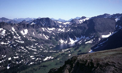 |
| The Chiwaukum Mountains in the Chelan quadrangle, looking southwest. In the middle ground is Larch Lake, a glacial tarn carved from Chiwaukum Schist of the Nason terrane. The distant peaks are underlain by the Mount Stuart batholith and rocks of the Ingalls Tectonic Complex. |
|
SUMMARY The
Chelan quadrangle hosts a wide variety of rocks and deposits and display
a long geologic history ranging from possible Precambrian to Recent. Two
major structures, the Leavenworth and Entiat faults divide cross the quadrangle
from southeast to northwest and bound the Chiwaukum "graben",
a structural low preserving Tertiary sedimentary rocks between blocks
of older, metamorphic and igneous rocks. Pre-Tertiary
metamorphic rocks in the quadrangle are subdivided into five major tectonostratigraphic
terranes: (1) the Ingalls terrane, equivalent to the Jurassic Ingalls
Tectonic Complex of probable mantle and deep oceanic rocks origin, (2)
the Nason terrane, composed of the Chiwaukum Schist and related gneiss,
(3) the Swakane terrane, made up entirely of the Swakane Biotite Gneiss,
a metamorphosed, possibly Precambrian, sedimentary and/or volcanic rock,
(4) the Mad River terrane composed mostly of the rocks of the Napeequa
River area (Napeequa Schist), a unit of oceanic protolith now considered
part of the Chelan Mountains terrane (the Mad River terrane has been abandoned,
2001), and (5) the Chelan Mountains terrane, dominated by the Chelan Complex
of Hopson and Mattinson (1971) which is composed of migmatite and gneissic
to tonalite of deep-seated igneous and metamorphic origin.During an episode
of Late Cretaceous regional metamorphism, all the terranes were intruded
by deepseated tonalite to granodiorite plutons, including the Mount Stuart
batholith, Ten Peak and Dirty Face plutons, and the Entiat pluton and
massive granitoid rocks of the Chelan Complex. The Duncan
Hill pluton intruded rocks of the Chelan Mountains terrane in the Middle
Eocene. At about the same time fluvial arkosic sediment of the Chumstick
Formation was deposited in a depression. The outpouring of basalt lavas
to the southeast of the quadrangle during the Miocene built up the Columbia
River Basalt Group. These now slightly warped lavas lapped onto the uplifted
older rocks. Deformation, uplift, and erosion recorded in the rocks and deposits of the quadrangle continued into post-Miocene time. Quaternary deposits reflect advances of glaciers down the major valleys, a complicated history of catastrophic glacial floods down the Columbia River, the formation of lakes in the Columbia and Wenatchee river valleys by landslides and flood backwaters, and hillslope erosion by large and small landslides and debris flows. |
Download the geologic map as a PDF file (8.4 MB)
Download the accompanying pamphlet as a PDF file (2.7 MB)
Jump to USGS Data Series 184: Database for the Geologic Map of the Chelan 30-Minute by 60-Minute Quadrangle, Washington (I-1661)
Download a free copy of Adobe Reader
| Help | PDF help | Geopubs main page | I-map |
This map and the accompanying pamphlet are also available from:
USGS Information
Services, Box 25286,
Federal Center, Denver, CO 80225
telephone: 888-ASK-USGS; e-mail: [email protected]
| Department of the Interior | U.S. Geological Survey | Geologic Division | Western Earth Surface Processes |