Western Mineral Resources
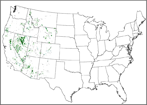
Public Land Survey sections (shown in green) that contained an active claim in 2004 (from figure 1)
Abstract
Statistical compilations of mining claim activity on Federal Land derived from the Bureau of Land Management's LR2000 database have been published by the U.S Geological Survey. This report updates Causey (2005) by adding statistics for an additional year of mining claim records, incorporating any corrections in older data done by BLM, adding a Public Land Survey spatial database for South Dakota, and improving correlation of the statistics to spatial databases in Washington and Nevada.
The statistics compiled from the LR2000 database are counts of number of active mining claims in a section each year from 1976 to 2004 for all states within the contiguous United States. Claims are broken down by lode and placer types and a dataset is provided summarizing all claims including millsite and tunnel-site claims. One table presents data by case type, case status, and number of claims in a section. This report includes a spatial database for each state in which mining claims were recorded. A field is present in both datasets that allows the statistical data to be joined to the spatial databases so that spatial displays and analysis can be done using appropriate software.
The data show how mining claim activity has changed in intensity, space, and time. Variations can be examined on a state, as well as a national level. The data are tied to a section of land, approximately 640 acres, which allows it to be used at regional, as well as local scale. It is restricted in that it only encompasses Federal land.
| File
Name |
File
Type and Description |
File
Size |
| | ||
| TEXT |
||
| The main text of this paper as a 26-page PDF file | 624 KB
| |
| Metadata as an ASCII text file | 16 KB
| |
| DATA PACKAGE |
||
| Package of data from all 15 states in a Zip file | 28.9 MB compressed (opens to 400 MB)
| |
| DATA FOLDERS
(Each of these folders contains both uncompressed data and the same data compressed in a Zip file.) |
||
- - - - - - - - - - - - - - - |
48.4 MB |
|
- - - - - - - - - - - - - - - |
1.5 MB |
|
- - - - - - - - - - - - - - - |
57.1 MB |
|
- - - - - - - - - - - - - - - |
35.6 MB |
|
- - - - - - - - - - - - - - - |
0.41 MB |
|
- - - - - - - - - - - - - - - |
30.2 MB |
|
- - - - - - - - - - - - - - - |
23.2 MB |
|
- - - - - - - - - - - - - - - |
0.29 MB |
|
- - - - - - - - - - - - - - - |
86.8 MB |
|
- - - - - - - - - - - - - - - |
23.5 MB |
|
- - - - - - - - - - - - - - - |
23.6 MB |
|
- - - - - - - - - - - - - - - |
4.8 MB |
|
- - - - - - - - - - - - - - - |
48.5 MB |
|
- - - - - - - - - - - - - - - |
11.5 MB |
|
- - - - - - - - - - - - - - - |
32.5 MB |
|
For questions about the content of this report, contact Doug Causey
Download a current version of Adobe Reader for free
| Help
| PDF help
| Publications main page | Western Data Series reports |
| Geologic
Division | Western Mineral Resources
|
This report is available only on the Web

![]() U.S. Department of the Interior | U.S. Geological Survey
U.S. Department of the Interior | U.S. Geological Survey
URL: https://pubs.usgs.gov/ds/2006/228/
Page Contact Information: Michael Diggles
Page Last Modified: October 18, 2007