Data Series 437
· Abstract · Introduction—Video of Exploration and Production Through Time · Undiscovered Oil and Gas Resources in the Southwestern Wyoming Province · Undiscovered Gas in the Mesaverde Total Petroleum System · The Almond Continuous Gas Assessment Unit · The Rock Springs–Ericson Gas Assessment Unit · Undiscovered Gas in the Mesaverde–Lance–Fort Union Composite Total Petroleum System · The Mesaverde–Lance–Fort Union Continuous Gas Assessment Unit · Undiscovered Gas in the Lewis Total Petroleum System · The Lewis Continuous Gas Assessment Unit · Undiscovered Gas in the Hilliard-Baxter-Mancos Total Petroleum System · The Hilliard-Baxter-Mancos Continuous Gas Assessment Unit · Undiscovered Gas in the Mowry Composite Total Petroleum System · The Mowry Continuous Gas Assessment Unit · Undiscovered Gas in the Lance–Fort Union Composite Total Petroleum System · The Lance–Fort Union Continuous Gas Assessment Unit · Reservoirs That Contain the Majority of Undiscovered Gas Resources |
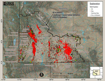
Introduction—Video of Exploration and Production Through TimeIn order to provide a historical perspective of petroleum exploration activity in the Wyoming Landscape Conservation Initiative (WLCI), the USGS Central Energy Resources Team has developed a video clip. This video shows exploration and production in 5-year increments from 1901, when the first gas well was drilled in southwestern Wyoming, to the spring of 2008. Well data used in this report was retrieved from the Wyoming Oil and Gas Conservation Commission (WOGCC) in the spring of 2008. Field names of some of the large oil and gas fields show up during the time interval that the field was discovered. Figure 1 shows oil and gas wells from the WOGCC, overlying imagery from ArcGIS Online (ESRI, 2008a) and shaded relief from the geography network (ESRI, 2000a). All map figures use the imagery from ArcGIS Online and shaded relief from the geography network. To start the oil and gas exploration and production video, click on the image, below. |

![]() U.S. Department of the Interior |
U.S. Geological Survey
U.S. Department of the Interior |
U.S. Geological Survey
URL: http://pubsdata.usgs.gov/pubs/ds/437/html/introduction.html
Page Contact Information: GS Pubs Web Contact
Page Last Modified: Monday, 28-Nov-2016 14:30:17 EST