Data Series 437
· Abstract · Introduction—Video of Exploration and Production Through Time · Undiscovered Oil and Gas Resources in the Southwestern Wyoming Province · Undiscovered Gas in the Mesaverde Total Petroleum System · The Almond Continuous Gas Assessment Unit · The Rock Springs–Ericson Gas Assessment Unit · Undiscovered Gas in the Mesaverde–Lance–Fort Union Composite Total Petroleum System · The Mesaverde–Lance–Fort Union Continuous Gas Assessment Unit · Undiscovered Gas in the Lewis Total Petroleum System · The Lewis Continuous Gas Assessment Unit · Undiscovered Gas in the Hilliard-Baxter-Mancos Total Petroleum System · The Hilliard-Baxter-Mancos Continuous Gas Assessment Unit · Undiscovered Gas in the Mowry Composite Total Petroleum System · The Mowry Continuous Gas Assessment Unit · Undiscovered Gas in the Lance–Fort Union Composite Total Petroleum System · The Lance–Fort Union Continuous Gas Assessment Unit · Reservoirs That Contain the Majority of Undiscovered Gas Resources |
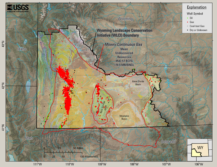
The Mowry Continuous Gas Assessment Unit (8.5 TCFG)The Mowry is a composite system because there are multiple source rocks present within about a 1,000-ft stratigraphic interval, and the relative contribution of petroleum from individual sources cannot be distinguished on the basis of data presently available (Kirschbaum and Roberts, 2005). The name Mowry is applied to the TPS because it is by far the most important contributor to the petroleum system (Burtner and Warner, 1984). Hydrocarbons have not been directly typed back to the Mowry, but the Mowry/Aspen is the Cretaceous shale with the highest total organic carbon content (Burtner and Warner, 1984) and is thought to be the dominant contributor of petroleum (Burtner and Warner, 1984; Law and Clayton, 1987). On outcrops just west of the Province boundary, the Frontier Formation consists of five members in ascending order: the Chalk Creek, Coalville, Allen Hollow, Oyster Ridge, and Dry Hollow Members (Hale, 1960; M’Gonigle and others, 1995). Along the northeast margin of the province, the Frontier Formation is 600–1,000 ft thick and is divided into three members: in ascending order: the Belle Fourche, the Emigrant Gap (formerly called the unnamed member), and the Wall Creek (Merewether, 1983; Mieras, 1993). Production from conventional accumulations of the Mowry Composite TPS is from anticlines, fault-bounded closures, stratigraphic traps, or combinations of the three (Cardinal and Stewart, 1979; Miller and others, 1992). The most important structure influencing conventional accumulation is the Rock Springs uplift (Kirschbaum and Roberts, 2005). Production from continuous (unconventional) accumulations is concentrated on the Moxa arch, presumably associated with intense fracturing and minor faulting on the structure (see Dutton and others, 1992; Anderson and Dietz, 2003). Figure 19 shows the location of the Mowry Continuous Gas AU, the mean estimate of undiscovered gas and gas liquids in that AU, and wells from the WOGCC that produce from or terminate in units of the Mowry Composite TPS and have a completion date of 2001 or earlier.
Figure 19. Wells from units of the Mowry Composite TPS at the time of the assessment (through 2001). Figure 20 includes the same data as figure 19, with post-2001 wells added to show how drilling of wells to units of the Mowry Composite TPS has progressed to the spring of 2008 WOGCC.
Figure 20. Wells that produce from units of the Mowry Composite TPS as of spring, 2008. Since the 2002 assessment, 1003 additional wells have been completed in the units of the Mowry Composite TPS (WOGCC). |

![]() U.S. Department of the Interior |
U.S. Geological Survey
U.S. Department of the Interior |
U.S. Geological Survey
URL: http://pubsdata.usgs.gov/pubs/ds/437/html/mowryau.html
Page Contact Information: GS Pubs Web Contact
Page Last Modified: Monday, 28-Nov-2016 14:30:23 EST