
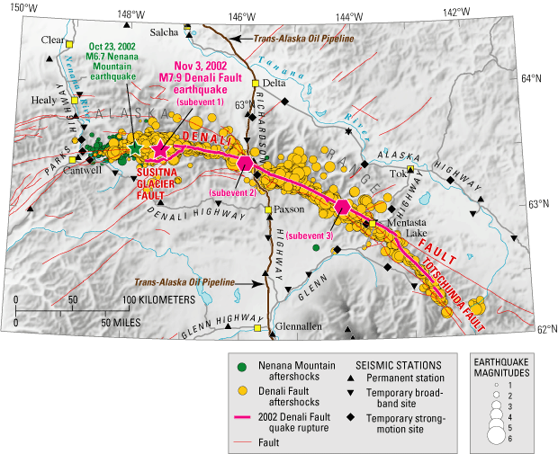
| A powerful magnitude 7.9 earthquake struck Alaska on November 3, 2002, rupturing the Earth's surface for 209 miles along the Susitna Glacier, Denali, and Totschunda Faults. Striking a sparsely populated region, it caused thousands of landslides but little structural damage and no deaths. Although the Denali Fault shifted about 14 feet beneath the Trans-Alaska Oil Pipeline, the pipeline did not break, averting a major economic and environmental disaster. This was largely the result of stringent design specifications based on geologic studies done by the U.S. Geological Survey (USGS) and others 30 years earlier. Studies of the Denali Fault and the 2002 earthquake will provide information vital to reducing losses in future earthquakes in Alaska, California, and elsewhere. |
Shortly after midday on November
3, 2002, a magnitude 7.9 earthquake ruptured the Denali Fault in the rugged
Alaska Range, about 90 miles south of Fairbanks. Called the Denali Fault earthquake,
this shock was the strongest ever recorded in the interior of Alaska. Although
comparable in size and type to the quake that devastated San Francisco in 1906,
the Denali Fault earthquake caused no deaths and little damage to structures
because it struck a sparsely populated region of south-central Alaska.
 |
|
| The
November 3, 2002, magnitude (M) 7.9 Denali Fault earthquake was the strongest
ever recorded in the interior of Alaska. Like most earthquakes of its size,
it was complex, consisting of several subevents. It started with thrust
(upward) motion on a previously unknown fault, now called the Susitna Glacier
Fault. This rupture continued on the Denali Fault, where largely horizontal
"right-lateral" movement (in which the opposite side moves to
the right, when you look across the fault) propagated eastward at more than
7,000 miles per hour. As the rupture propagated, it offset streams, glacial
ice, frozen soil, and rock, opening some cracks so wide that they could
engulf a bus. The rupture crossed beneath the Trans-Alaska Oil Pipeline
and terminated on the Totschunda Fault, 184 miles east of the epicenter,
about 90 seconds after the quake began. The maximum horizontal movement
(fault offset) of about 29 feet occurred in the eastern part of the rupture,
near subevent 3. |
 |
This powerful shock may have been triggered by a magnitude 6.7 temblor, the
Nenana Mountain earthquake, that occurred nearby on the same fault 10 days earlier.
Like the Denali Fault quake, the Nenana Mountain shock caused only limited damage
because of its remote location. In contrast, the 1994 Northridge, California,
earthquake, which had the same magnitude, caused 67 deaths and $40 billion in
damage when it struck the densely populated Los Angeles region.
The Denali Fault earthquake
ruptured the Earth's surface for 209 miles, crossing beneath the vital Trans-Alaska
Oil Pipeline, which carries 17% of the U.S. domestic oil supply. Although slightly
damaged by movement on the fault and by intense shaking, the
pipeline did not break in the quake, averting a major economic and environmental
disaster. This success is a major achievement in U.S. efforts to reduce earthquake
losses.
Violent, prolonged shaking
from the quake triggered thousands of landslides, especially on the steep slopes
of the Alaska Range. Mountainsides gave way, burying the valleys and glaciers
below in deposits of rock and ice as much as 15 feet thick. The majority of
landslides clustered in a narrow band extending about 8 to 12 miles on either
side of the rupture.
One facility that was badly damaged by the earthquake was the runway at Northway
Airport, 40 miles from the eastern part of the November 3, 2002, fault rupture.
The runway was rendered unusable by lateral spreading, accompanied by sand boils.
These effects were the result of a phenomenon called "liquefaction,"
in which strong, prolonged earthquake shaking transforms loose, water-saturated
sediments into a liquid slurry. Areas that experienced liquefaction during the
earthquake include much of the Tanana River Valley north and east of the rupture
and other locations near smaller rivers.
Like some other large earthquakes, the Denali Fault quake triggered small shocks
as far as 2,000 miles away, mainly in volcanic areas. Yellowstone National Park
had the most energetic swarm of triggered earthquakes. Following the Denali
Fault earthquake, Lake Union in Seattle experienced an earthquake-induced seiche,
or water sloshing, which knocked many houseboats off their moorings and caused
minor damage. Seiches were seen as far away as Lake Pontchartrain in Louisiana.
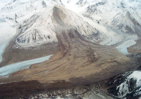 |
This huge landslide from an unnamed 7,000-foot-high peak in the Alaska Range, less than 10 miles west of the Trans-Alaska Oil Pipeline, was triggered by the 2002 Denali Fault earthquake. The fault rupture offset the ice of the mile-wide Black Rapids Glacier, in the foreground, which the landslide subsequently covered. |
The locations of the Nenana
Mountain and Denali Fault earthquakes and their aftershocks were determined
by the Alaska Earthquake Information Center (AEIC) at the University of Alaska
Fairbanks. AEIC receives data from more than 370 seismic stations, integrating
all seismic networks in Alaska. A few of these stations are part of the new
Advanced National Seismic System (ANSS) being deployed
by the USGS and cooperators. After the Nenana Mountain earthquake, AEIC installed
several temporary seismographs, including some ANSS instruments. When the Denali
Fault earthquake struck a few days later, these stations helped to provide crucial
data. Additional instruments were deployed after the Denali Fault quake, and
as of December 2002, a total of 26 temporary seismic stations were gathering
data on the quake's aftershocks.
During the 10 days following
the Denali Fault earthquake, geologists from the USGS and Alaska Division of
Geological and Geophysical Surveys, as well as several universities, mapped
and measured the earthquake rupture on the ground and using aircraft. They identified
the previously unknown Susitna Glacier Fault in the area where the quake began
and showed that the rest of the rupture exactly followed an older rupture that
geologists had documented in the 1970's. They also located major landslides
caused by the quake. The pattern of landsliding may help to better estimate
levels of shaking along the length of the fault, especially because of the sparsity
of seismic instruments in this rugged mountainous region.
Because the
2002 Denali Fault earthquake occurred on a "strike-slip" fault,
like the San Andreas Fault, it offers a realistic example of effects likely
to accompany the next major earthquake in California. The Denali
Fault quake is similar to three earthquakes that ruptured the San Andreas Fault
in the past few centuries. These include the magnitude 7.8 San Francisco
earthquake in 1906, the magnitude 7.9 Fort Tejon earthquake in 1857 north of
Los Angeles, and a quake that struck east of what is now Los Angeles in about
1685. Evidence of the 1685 earthquake was only discovered in the past 20 years.
The 1857 California and
2002 Alaska earthquakes struck far from major cities, causing little or no loss
of life. However, the 1906 earthquake near San Francisco killed at least 700
people (the actual death toll was probably 3 to 4 times greater). Many geologists
who study evidence of ancient earthquakes in deposits and landforms along the
southernmost San Andreas Fault, where the 1685 earthquake occurred, have concluded
that a major quake on this segment of the fault is likely to happen again in
the near future. Should such a quake occur today, San Bernardino, Los Angeles,
and other populations centers in southern California could suffer heavy damage
and loss of life.
The survival of the Trans-Alaska
Oil Pipeline in the 2002 Denali Fault earthquake demonstrates the value of combining
careful geologic studies of earthquake hazards and creative engineering in designing
and protecting such important structures and lifelines. Instrumental recordings
of ground motion near earthquakes like the Denali Fault quake are critical for
improving engineering design, but such quakes do not occur often. Following
the Denali Fault earthquake, adjacent fault segments have been stressed, increasing
the likelihood of additional earthquakes on those segments. This presents a
rare opportunity to catch a major earthquake in the act. However, full ANSS
instrumentation on either end of the 2002 rupture is critical if this goal is
to be achieved.
By studying earthquakes like the 2002 Denali Fault earthquake, scientists and
engineers gain the knowledge necessary to reduce the vulnerability of buildings
and other structures to damage in these inevitable and terrifying events. USGS
studies of the Denali Fault earthquake are part of the National Earthquake Hazard
Reduction Program's ongoing efforts to safeguard lives and property from the
future quakes that are certain to strike in Alaska, California, and elsewhere
in the United States.
Compiled By Gary S. Fuis and Lisa A. Wald
Edited
by James W. Hendley II and Peter H. Stauffer
Graphic design by Susan Mayfield, Sara Boore, Eleanor Omdahl, and J. Luke Blair; Web layout by Carolyn Donlin
COOPERATING
ORGANIZATIONS
Alaska Division of Geological and Geophysical Surveys
Alaska Earthquake Information Center, Geophysical
Institute, University of Alaska Fairbanks
Alaska Volcano Observatory
Alyeska Pipeline Service Company
California Institute of Technology
Central Washington University
Humboldt State University
University of California Berkeley
West Coast and Alaska Tsunami Warning Center
For more
information contact:
Earthquake Information Hotline (650) 329-4085
U.S. Geological Survey, Mail Stop 977
345 Middlefield Road, Menlo Park, CA 94025
Visit the USGS Earthquake Hazards Program
website to learn more
PDF
version of this fact sheet (2.2 MB)
REDUCING
EARTHQUAKE LOSSES THROUGHOUT THE UNITED STATES
For questions about the content of this report, contact Gary Fuis
Download the current version of Acrobat Reader for free
| Help | PDF help | Geopubs main page | Fact Sheets |
| Department
of the Interior | Privacy Statement
| Disclaimer | Accessibility
|
URL of this
page: https://pubs.usgs.gov/fs/2003/fs014-03/
Maintained by: Michael Diggles
Created: February 5, 2003
Last modified: May 17, 2005 (mfd)